From Surf Wiki (app.surf) — the open knowledge base
Dhaka District
| Field | Value |
|---|---|
| name | Dhaka District |
| image_skyline | {{Photomontage |
| size | 250 |
| photo1a | Bangladesh National Parliament House.jpg |
| photo1b | Baitul Mukarram National Mosque in 2022.16.jpg |
| photo2a | National Martyrs’ Memorial 08.jpg |
| photo2b | Lalbagh Kella (Lalbagh Fort)-12.jpg |
| photo3a | A sunset from the old town (27802264372).jpg |
| photo3b | Shiva temples Dhakeshwari Mandir 2 by Ragib Hasan.jpg |
| image_caption | Jatiya Sangsad Bhaban, Baitul Mukarram National Mosque, Lalbagh Fort, Old Dhaka skyline, Dhakeshwari Temple, National Martyrs' Memorial |
| settlement_type | District of Bangladesh |
| image_map | BD Dhaka District locator map.svg |
| map_caption | Location of Dhaka District within Bangladesh |
| mapframe | yes |
| mapframe-zoom | 9 |
| mapframe-point | none |
| pushpin_label_position | right |
| coordinates | |
| subdivision_type | Country |
| subdivision_name | Bangladesh |
| subdivision_type1 | Division |
| subdivision_name1 | Dhaka |
| seat_type | Headquarters |
| seat | Dhaka |
| leader_title | Deputy Commissioner |
| leader_name | Md. Rezaul Karim |
| leader_title1 | District Council Chairman |
| leader_name1 | Md. Mahbubur Rahman |
| leader_title2 | Chief Executive Officer |
| leader_name2 | Md. Mamunur Rashid |
| area_total_km2 | 1463.6 |
| population_footnotes | |
| population_total | 14734701 |
| population_as_of | 2022 |
| population_rural | 3497484 |
| population_rank | 1st in Bangladesh |
| population_demonym | Dhakai, Dhakaiya |
| population_density_km2 | auto |
| population_urban | 11237217 |
| postal_code_type | Postal code |
| postal_code | 1000 |
| demographics_type1 | GDP (2015 US dollar) |
| demographics1_title1 | Total |
| demographics1_info1 | $50.1 billion (2023) |
| demographics1_title2 | Per capita |
| demographics1_info2 | $3,600 (2023) |
| demographics_type2 | GDP (PPP, 2015 international dollar) |
| demographics2_title2 | Total |
| demographics2_info2 | $167.2 billion (2023) |
| demographics2_title3 | Per capita |
| demographics2_info3 | $12,100 (2023) |
| area_code | 02 |
| iso_code | BD-13 |
| native_name | ঢাকা জেলা |
| native_name_lang | bn |
| other_name | Dhaka Zilla |
| blank_name_sec1 | HDI (2023) |
| blank_info_sec1 | 0.741 |
| · 1st of 20 | |
| website |
the district
| mapframe-zoom = 9 | mapframe-point = none · 1st of 20
Dhaka District () is a district in central Bangladesh, and is the densest district in the nation. It is a part of the Dhaka Division. Dhaka, the capital of Bangladesh, rests on the eastern banks of the Buriganga River which flows from the Turag to the southern part of the district. The former Dhaka city corporation occupied only about a fifth of the area of Dhaka district until 2011 where the municipal corporation was fractionated and rearranged in North and South corporations due to being the economic, political and cultural centre of the district and also the country. Dhaka District consists of Dhaka city, Keraniganj, Nawabganj, Dohar, Savar and Dhamrai upazila. Dhaka District is an administrative entity, and like many other cities, it does not cover the modern conurbation which is Greater Dhaka, which has spilled into neighbouring districts, nor does the conurbation cover the whole district, as there are rural areas within the district.
Geography
Dhaka District shares borders with Gazipur and Tangail to the north, Munshiganj and Rajbari to the south, Narayanganj to the east and Manikganj to the west. The main rivers flowing through this district are Padma, Kaliganga, Dhaleshwari, Ichamati, Shitalakshya, Buriganga and numerous smaller rivers including Bangshi, Turag, Balu, Elamjani, Alam, Bherujkha, Ramkrishnadi, Elisamari, Tulsikhali. Major lakes (Bengali: বিল) include Belai, Saldaher, Labandaher, Churain, Damsharan and Kiranjir Beel. The annual average temperature of the district is maximum 41.1 °C, minimum 11.5 °C; the average annual rainfall 1931mm.
History
Main article: History of Dhaka
The administrative Dhaka District was first established in 1772, but the existence of urbanised settlements in the area that is now Dhaka city—dates from the 7th century. The present-day Savar was the capital of the Sanbagh Kingdom during the seventh and eighth centuries. The city area of Dhaka was ruled by the Buddhist kingdom of Kamarupa and the Pala Empire before passing to the control of the Hindu Sena dynasty in the 9th century. Many believe that the name of the city was derived after the establishment of the goddess Dhakeshwari's temple by Ballal Sena in the 12th century. Dhaka and its surrounding area were identified as Bengalla around that period. The town itself consisted of a few market centres like Lakshmi Bazar, Shankhari Bazar, Tanti Bazar, Patuatuli, Kumartuli, Bania Nagar and Goal Nagar. After the Sena dynasty, Dhaka was successively ruled by the Turkish and Afghan governors descending from the Delhi Sultanate before the arrival of the Mughals in 1608.
The development of townships and significant growth in population came as the city was proclaimed the capital of Bengal under Mughal rule in 1608. During Mughal rule the areas currently under Dhaka district were famous for their textile products—especially the Muslin. Mughal subahdar Islam Khan was the first administrator of the city. Khan named the town "Jahangir Nagar" (City of Jahangir) in honour of the Mughal emperor Jahangir, although this name was dropped soon after Jahangir's death. The main expansion of the city took place under the Mughal general Shaista Khan. The city then measured 19 by 13 km, with a population of nearly a million people. The city passed to the control of the British East India Company in 1757 after the Battle of Plassey and eventually to the Crown, British Empire, in 1765 at the Battle of Buxar. The city's population shrank dramatically during this period as the prominence of Kolkata rose, but substantive development and modernisation eventually followed. A modern civic water supply system was introduced in 1874 and an electricity supply was launched in 1878. The Dhaka Cantonment was established near the city, serving as a base for British Indian military personnel.
.jpg)
During the abortive Partition of Bengal in 1905, Dhaka was declared to be the capital of the newly established state of Eastern Bengal and Assam, but Bengal was reunited in 1911. The rural areas under the present Dhaka district, especially Dohar Upazila were used for the production of indigo.
Following the partition of Bengal in (1947) appending the partition of British India in 1947, Dhaka became the capital of East Bengal as a part of the new Muslim state of Pakistan, while the western part of Bengal with a majority Hindu population had become a part of the new and independent India, designated as West Bengal with Calcutta as state capital. Calcutta witnessed communal violence that left thousands of people dead. A large proportion of the city's Hindu population departed for India, while the city received hundreds of thousands of Muslim immigrants from Calcutta, India. The city's population rose dramatically in a very short period of time, which created severe shortages and infrastructural problems.{{cite book | chapter-url=http://en.banglapedia.org/index.php?title=Dhaka | access-date=30 June 2015 | archive-date=16 May 2019 | archive-url=https://web.archive.org/web/20190516050956/http://en.banglapedia.org/index.php?title=Dhaka | url-status=live | access-date = 27 September 2006 | archive-date = 9 July 2015 | archive-url = https://web.archive.org/web/20150709112039/http://www.thefreelibrary.com/Calcutta+and+Dhaka:+a+tale+of+two+cities.-a0127013002 | url-status = live
The 1970 Bhola cyclone devastated much of the region, killing an estimated 500,000 people. More than half the city of Dhaka was flooded and millions of people were marooned. With public anger growing against ethnic discrimination and poor cyclone relief efforts from the central government, Bengali politician Sheikh Mujibur Rahman held a nationalist rally on 7 March 1971 at the Race Course Ground. An estimated one million people attended the gathering, leading to Ziaur Rahman's 26 March declaration of Bangladesh's independence. In response, the Pakistan Army launched Operation Searchlight, which led to the arrests, torture and killing of hundreds of thousands of people, mainly Hindus and Bengali intellectuals.
During the Bangladesh Liberation War the Pakistan army arrested and killed fourteen Muktijoddhas from Dhamrai Bazar. A mass grave created during the war still exists in the western side of Kalampur Bazar.{{cite book | chapter-url=http://en.banglapedia.org/index.php?title=Dhamrai_Upazila | access-date=30 June 2015 | archive-date=4 March 2016 | archive-url=https://web.archive.org/web/20160304211141/http://en.banglapedia.org/index.php?title=Dhamrai_Upazila | url-status=live
The fall of Dhaka city to the allied forces led by Jagjit Singh Arora on 16 December marked the surrender of the Pakistani army. The post-independence period has seen a rapid and massive growth of the city population, attracting migrant workers from rural areas across Bangladesh. A real estate boom followed with urban sprawl and the development of new settlements such as Gulshan, Banani and Motijheel.
During the Quota Reform Movement in Dhaka, students from a wide range of schools, colleges, and universities united to demand a fairer government job recruitment system. The protests became highly visible in front of major educational institutions, with students carrying banners, placards, and chanting slogans to draw attention to their cause. Schools such as Maple Leaf International School and Mastermind English Medium School became early centers of peaceful demonstration, where students organized sit-ins and small marches. The movement quickly spread to college campuses across the city, including Dhaka College, Notre Dame College, and others, while Dhaka University emerged as the heart of the protests. Students occupied central areas like the TSC (Teacher-Student Center) and Shahbagh intersections, forming human chains and holding long sit-ins that lasted for days.
Administration
- Administrator of Zila Parishad: Mr. Md Mahbubur Rahman
- Deputy Commissioner (DC): Md. Mominur Rahman
Subdivisions

The district does not cover all parts of Greater Dhaka, and Greater Dhaka does not include all parts of the district, which includes rural areas. The district consists of 57 thanas (50 in city corporations, 7 in upazilas), 5 upazilas, 86 unions, 974 mauzas, 1999 villages, 2 City Corporations, 129 City Wards, 855 City Mahallas, 3 paurashavas, 27 wards and 133 mahallas.
The five upazilas in Dhaka district are:
- Dhamrai Upazila, suburban and rural
- Dohar Upazila, suburban and rural
- Keraniganj Upazila, suburban
- Nawabganj Upazila, suburban and rural
- Savar Upazila, suburban
The municipal area of Dhaka City is under the jurisdiction of the Dhaka North City Corporation and Dhaka South City Corporation; for administrative purposes, the municipal area is divided into 92 wards. Tejgaon Development Circle is merged with the two city corporations.
Demographics
According to the 2022 Census of Bangladesh, Dhaka District had 4,035,241 households and a population of 14,734,701 with an average 3.62 people per household. Among the population, 2,231,856 (15.15%) inhabitants were under 10 years of age. The population density was 10,067 people per km2. Dhaka District had a literacy rate (age 7 and over) of 84.88%, compared to the national average of 74.80%, and a sex ratio of 865 females per 1000 males. Approximately 76.26% of the population lived in urban areas. The ethnic population was 27,137.
|1981 |4023838 |1991 |5839642 |2001 |8511228 |2011 |12043977 |2022 |14734701
Religion
| Religion | 1941 | 1981 | 1991 | 2001 | 2011 | 2022 | Pop. | % | Pop. | % | Pop. | % | Pop. | % | Pop. | % | Pop. | % | Total Population | 997,906 | 100% | 4,023,838 | 100% | 5,839,642 | 100% | 8,511,228 | 100% | 12,043,977 | 100% | 14,734,701 | 100% | |
|---|---|---|---|---|---|---|---|---|---|---|---|---|---|---|---|---|---|---|---|---|---|---|---|---|---|---|---|---|---|---|---|---|
| Islam [[File:Star_and_Crescent.svg | 15x15px]] | 565,552 | 56.67% | 3,672,579 | 91.27% | 5,414,536 | 92.72% | 8,020,372 | 94.23% | 11,400,096 | 94.65% | 13,980,953 | 94.88% | |||||||||||||||||||
| Hinduism [[File:Om.svg | 16x16px]] | 422,284 | 42.32% | 316,612 | 7.87% | 379,397 | 6.50% | 441,213 | 5.18% | 566,368 | 4.70% | 672,269 | 4.56% | |||||||||||||||||||
| Christianity [[File:Christian_cross.svg | 21x21px]] | 7,073 | 0.71% | 26,063 | 0.65% | 36,354 | 0.62% | 41,395 | 0.49% | 62,064 | 0.52% | 63,402 | 0.43% | |||||||||||||||||||
| Others | 2,997 | 0.30% | 8,584 | 0.21% | 9,355 | 0.16% | 8,248 | 0.10% | 15,449 | 0.13% | 18,073 | 0.13% |
In 2011, Islam was the largest religion in the Dhaka district with 94.65% of the population. Hinduism was the second-largest religion with 4.70% of the population. 0.52% of the population were Christians, while Buddhists were only 0.11% of the population. Although all communities are predominantly urban, a greater percentage of Hindus live in rural areas than in other communities. The district of Dhaka has more than 12 000 mosques, 3012 Hindu mandirs, 530 churches, 174 Buddhist temples, three pagodas and a synagogue. For a long time, Islam has been the majority religion in Dhaka, with only 1300 mosques, but more mosques were recently built, and the district is now called the City of Mosques.
Economy

Dhaka is the commercial heart of Bangladesh. The city has a large middle class population, increasing the market for modern consumer and luxury goods.{{cite news | access-date = 2 October 2006 | archive-date = 24 March 2012 | archive-url = https://web.archive.org/web/20120324150041/http://news.bbc.co.uk/2/hi/south_asia/2018535.stm | url-status = live | access-date = 2 October 2006 | archive-date = 3 April 2023 | archive-url = https://web.archive.org/web/20230403235903/http://news.bbc.co.uk/2/hi/south_asia/3759396.stm | url-status = live | access-date = 27 September 2006 | archive-url = https://web.archive.org/web/20061203181903/http://www.prb.org/Template.cfm?Section=PRB&template=%2FContentManagement%2FContentDisplay.cfm&ContentID=3931 | archive-date = 3 December 2006 | url-status = dead | access-date = 27 September 2006 | archive-date = 8 March 2008 | archive-url = https://web.archive.org/web/20080308190144/http://news.bbc.co.uk/2/hi/south_asia/136074.stm | url-status = live
The main business districts of the city include Motijheel, Panthapath and Gulshan. Bashundhara City is a recently developed economic area that houses many high-tech industries and corporations and a shopping mall that is one of the largest in Southeast Asia, frequented daily by more than 25,000 people. The Export Processing Zone in Dhaka was set up to encourage the export of garments, textiles and other goods. The EPZ is home to 80 factories, which employ mostly women.{{cite news | access-date = 27 September 2006 | archive-date = 16 February 2021 | archive-url = https://web.archive.org/web/20210216223552/https://secure-uk.imrworldwide.com/v51.js | url-status = live
Places of interest
The historic city of Dhaka is the capital of Bangladesh and lies on the banks of the Buriganga River in the central area of Bangladesh. The old town of Dhaka, south of the city centre, is the site of most of the tourist attractions, including the Lalbagh Fort, the Stat Mosque, and the Ahsan Manzil Palace Museum.
Dhaka was predominantly a city of the Mughals, whose governors and viceroys built several palace, mosques and katrias. One example of this time is the Aurangabad Fort, commonly known as Lalbagh Fort. Also in this area of Dhaka is the Ahsan Manzil Plance Museum, the Bara Katra, the Cotta Katra and several mosques of note.
The old European quarter lies just north of Dhaka's old town, which houses the presidential place and the National Museum, Dhaka's commercial and diplomatic regions are northeast of this zone. Dhaka Zoo and the Botanical Gardens are a short taxi ride into the suburbs.
Once famed for its Muslin, Dhaka is now renowned for pink pearls and a rich tradition of handicrafts.
The Botanical garden is a park at Mirpur in Dhaka. It contains various species of plants. It is also a major tourist spot.
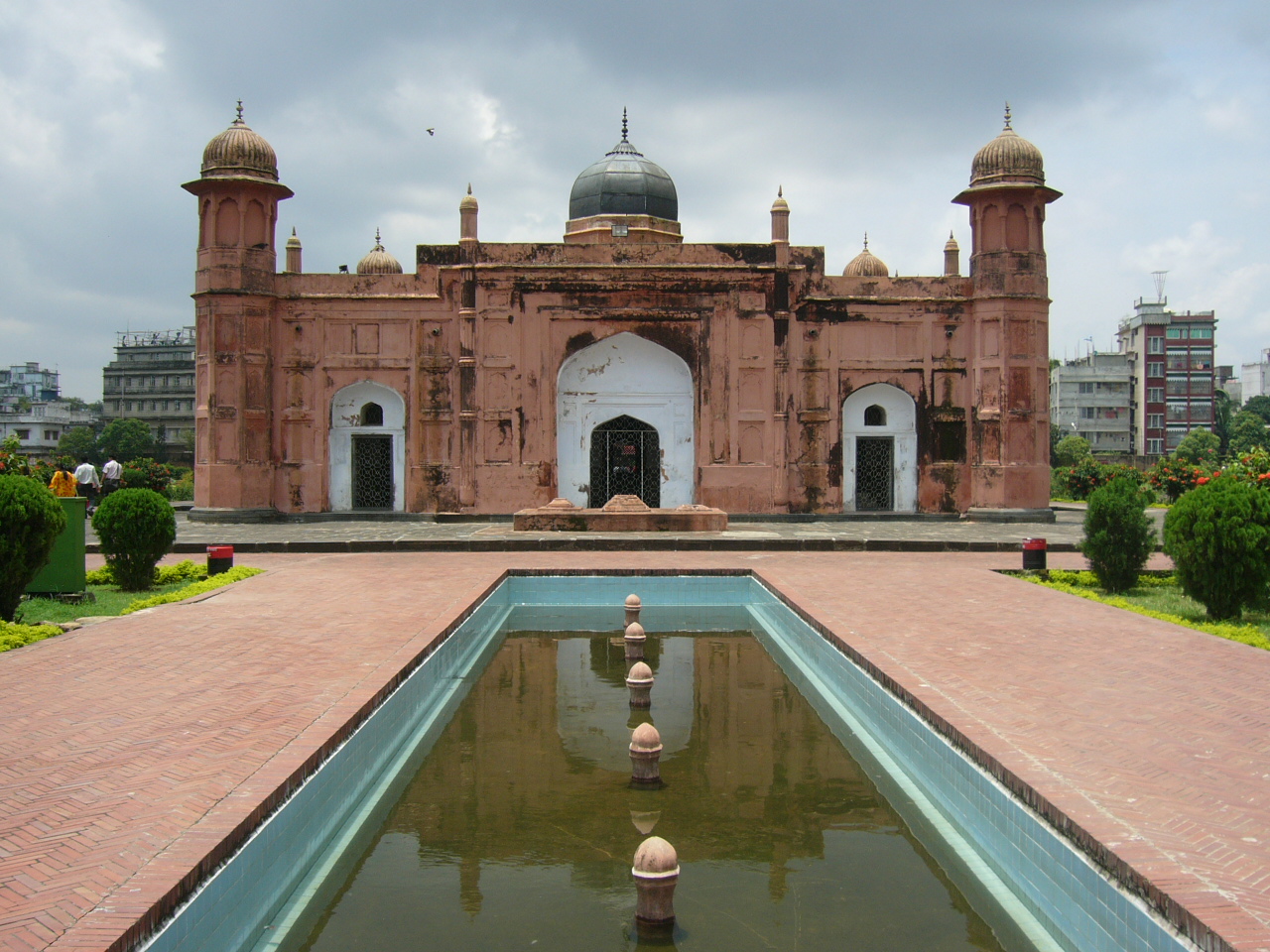
Lalbagh Fort
Main article: Lalbagh Fort
Built in 1678 by the Viceroy of Bengal, it contains a three-domed mosque, the tomb of Pari Bibi, the reputed daughter of Nawab Shaista Khan, the Audience Hall and the hammam of the Governor. Four Kilometres from the hotel.
Ahsan Manzil Palace Museum
Main article: Ahsan Manzil
A majestic place, it was once home to the Nawab of Dhaka, and houses 23 galleries displaying portraits, furniture and household articles.
Jatiyo Smriti Soudho
Jatiyo Smriti Soudho or National Martyrs' Memorial is a monument in Bangladesh. It is the symbol of the valour and the sacrifice of the martyrs of the Bangladesh Liberation War of 1971, which brought the independence of Bangladesh from Pakistani rule. The monument is located in Savar, about 35 Kilometres north-west of the capital, Dhaka.
Tara Mosque
Main article: Star Mosque
The Star Mosque, also known as Tara Masjid or Sitara Masjid, is a historic mosque located in the Armanitola area of Old Dhaka, Bangladesh. It was originally constructed in the first half of the 19th century by Mirza Ghulam Pir (also referred to as Mirza Ahmed Jan), a local nobleman. At the time of its construction, the mosque featured a simple architectural design, devoid of the elaborate decorations seen today. The structure was commonly referred to as the Mosque of Mirza Ghulam Pir, in honour of its founder. In 1926, the mosque underwent significant renovation under the patronage of Ali Jan Bepari, a local businessman. During this renovation, decorative elements—including the prominent blue star motifs—were added to the mosque's interior and exterior surfaces. Following these modifications, the mosque became popularly known as the Star Mosque (Tara or Sitara Masjid). Today, it is recognised for its ornate aesthetic and distinctive star-themed embellishments, which have become emblematic of its architectural identity.
Satmasjid
Satmasjid Road, located in the heart of Dhaka’s Dhanmondi area, is one of the city’s most important educational corridors, connecting thousands of students, teachers, and families to schools and colleges every day. The road links residential neighborhoods with major academic institutions, making it a vital route for daily school commutes and academic life. Over the years, Satmasjid Road has developed a strong reputation as a center of quality education, especially for its vigorous English-medium school culture. Prominent English-medium schools along or near Satmasjid Road include Maple Leaf International School, Mastermind English Medium School, Scholastica (Dhanmondi Campus), Academia School, Oxford International School, Daffodil International School, Sunshine Grammar School, Greenherald International School, and South Breeze School. These institutions have attracted students from across the city, reinforcing the road’s identity as a hub of modern education. Historically, Satmasjid Road evolved alongside Dhanmondi’s transformation from a planned residential area into a major urban and educational center, named after the historic Sat Gambuj Mosque (Sat Masjid) nearby. Today, the road not only serves as a physical connector but also as a symbol of Dhaka’s growing emphasis on education, diversity, and academic excellence.
National Museum
Main article: Bangladesh National Museum
The Bangladesh National Museum, located in Shahbag, Dhaka, is the country’s most important institution for preserving and showcasing its history, culture, and heritage. Established in 1913 as the Dhaka Museum and later renamed the National Museum, it plays a vital role in educating the public about Bangladesh’s rich past. The museum houses extensive collections covering archaeology, history, art, ethnography, natural history, and the Liberation War of 1971. Through its galleries, visitors can explore ancient artifacts, sculptures, manuscripts, traditional crafts, and exhibits that reflect the diverse cultural traditions of the people of Bangladesh. As a major cultural landmark in Dhaka, the National Museum serves not only as a center of learning for students and researchers but also as a symbol of national identity and historical awareness.
Bara Katra
Bara Katra was built between 1644 and 1646 CE to be the official residence of Mughal prince Shah Shuja, the second son of the emperor Shah Jahan. The prince endowed it to his diwan and the builder of the serai, Abul Qasim.
File:লাল কেল্লার মায়া.jpg|Lalbagh Fort File:Ahsan Manzil-Front View.jpg|Ahsan Manzil Image:Jatiyo Smriti Soudho, concrete modernist monument and memorial gardens, at Savar near Dhaka in central Bangladesh.jpg|Jatiyo Smriti Soudho at Savar, a tribute to the martyrs of the Bangladesh Liberation War File:Star Mosque 2023.jpg|Star Mosque File:Bangladesh National Museum southern side (01).jpg|Bangladesh National Museum File:Boro Katra 4 by Ashif Siddique.jpg|Bara Katra
Notes
References
Extyernal links
References
- zpdhaka.org
- "TelluBase—Dhaka Fact Sheet (Tellusant Public Service Series)".
- "Subnational HDI - Subnational HDI - Table - Global Data Lab".
- Molla, Md Tuhin. (2012). "Banglapedia: National Encyclopedia of Bangladesh". [[Asiatic Society of Bangladesh]].
- Harun-or-Rashid. (2012). "Banglapedia: National Encyclopedia of Bangladesh". [[Asiatic Society of Bangladesh]].
- "Transcript of Selective Genocide Telex".
- (16 December 2011). "AL men appointed administrators". The Daily Star.
- "List of Deputy Commissioners".
- "Community Report: Dhaka Zila, June 2012".
- (November 2023). "Population and Housing Census 2022 National Report". [[Bangladesh Bureau of Statistics]].
- (June 2024). "Population and Housing Census 2022 - District Report: Dhaka". [[Bangladesh Bureau of Statistics]].
- "Census of India, 1941 Volume VI Bengal Province".
- (September 2019). "Mughal mosques of Dhaka".
- "Dhaka". Encyclopædia Britannica.
- "City Mayors reviews the richest cities in the world in 2005". citymayors.com.
- Haider, M. H.. (2023-08-27). "The iconic Tara Masjid did not always have those stars!".
- (2024-04-28). "Heatwaves keep students away: Low attendance, illnesses plague school reopenings".
This article was imported from Wikipedia and is available under the Creative Commons Attribution-ShareAlike 4.0 License. Content has been adapted to SurfDoc format. Original contributors can be found on the article history page.
Ask Mako anything about Dhaka District — get instant answers, deeper analysis, and related topics.
Research with MakoFree with your Surf account
Create a free account to save articles, ask Mako questions, and organize your research.
Sign up freeThis content may have been generated or modified by AI. CloudSurf Software LLC is not responsible for the accuracy, completeness, or reliability of AI-generated content. Always verify important information from primary sources.
Report