From Surf Wiki (app.surf) — the open knowledge base
Department of La Libertad
Department of Peru

Department of Peru
| Field | Value |
|---|---|
| name | La Libertad |
| settlement_type | Department |
| image_skyline | Laguna Cañoncillo, Pacasmayo, Perú.jpg |
| image_caption | Lake Cañoncillo |
| image_flag | Bandera_de_La_Libertad_Peru.svg |
| image_shield | Escudo de La Libertad Peru.svg |
| shield_size | 60 |
| image_map | Peru - La Libertad Department (locator map).svg |
| map_caption | Location of La Libertad within Peru |
| subdivision_type | Country |
| subdivision_name | Peru |
| seat_type | Capital |
| seat | Trujillo |
| parts_type | Provinces |
| p1 | Ascope |
| p2 | Bolívar |
| p3 | Chepén |
| p4 | Gran Chimú |
| p5 | Julcán |
| p6 | Otuzco |
| p7 | Pacasmayo |
| p8 | Pataz |
| p9 | Sánchez Carrión |
| p10 | Santiago de Chuco |
| p11 | Trujillo |
| p12 | Virú |
| government_type | Regional Government |
| leader_title | Governor |
| leader_name | César Acuña |
| unit_pref | Metric |
| area_total_km2 | 25499.9 |
| elevation_footnotes | (Capital) |
| elevation_m | 34 |
| elevation_max_m | 4008 |
| elevation_min_m | 0 |
| population_total | 2077200 |
| population_as_of | 2022 |
| population_density_km2 | auto |
| population_demonym | liberteño/a, libertense |
| postal_code_type | UBIGEO |
| postal_code | 13 |
| area_code_type | Dialing code |
| area_code | 044 |
| iso_code | PE-LAL |
| website | www.regionlalibertad.gob.pe |
| blank_name_sec1 | Principal resources |
| blank_info_sec1 | Nation's largest sugar cane producer, and second-largest producer of rice. |
| blank2_name_sec1 | Poverty rate |
| blank2_info_sec1 | 18.4% |
| blank3_name_sec1 | Percentage of Peru's GDP |
| blank3_info_sec1 | 4.18% |
La Libertad () is a department of Peru. Located on the country's northwestern coast, it is the ninth smallest department in Peru, but is also its second-most populous after Piura, and the second-most densely populated after Lambayeque. Its capital is the coastal city of Trujillo, the nation's third biggest city.
La Libertad is the site of many of Pre-Columbian Peru's significant cultures, such as the Moche, the Wari, the Chimú and, ultimately, the Inca Empire. It was ultimately conquered by the Spanish Empire during the 16th century and, after a series of administrative changes, ultimately incorporated as the Intendancy of Trujillo in 1784. It played a significant role in the Peruvian War of Independence, after which it was created as one of the foundational provinces of the Protectorate of Peru. In 1825, it was given its current name.
Its territory was that of the intendancy, which originally included most of Peru's territory north and east of Lima, including that of the former General Command of Maynas. Due to its large size, its territory gradually shrank from 1832 to 1874, with the creation of the departments of Piura (1837), Amazonas (1832), Cajamarca (1855) and Lambayeque (1874), after which it virtually acquired its current borders.
It is the site of two important heritage sites designated as World Heritage Sites by UNESCO: Rio Abiseo National Park (designated in 1983) and Chan Chan (designated in 1986). Salaverry, its main port, is one of Peru's largest ports.
Etymology
The department's name honours its contribution to the Peruvian War of Independence. Prior to 1825, it was known as the Department of Trujillo.
History
As with most of the country's coastal and central region, the area was once the home to a number of Pre-Columbian peoples, notably the Chavín, Moche, Sican, and Wari peoples. The latter established an empire whose area would eventually be absorbed into the Inca Empire, the last pre-Columbian entity to exist prior to the arrival of the Spanish Empire.
Spanish period
Following the Spanish conquest of the Inca Empire, the area as a whole was incorporated into the Intendancy of Trujillo, a subdivision of the Viceroyalty of Peru. At the time, the area under its jurisdiction included present-day Lambayeque, Piura and Tumbes, as well as Guayaquil and El Oro in Ecuador.
Republican period
During the Peruvian War of Independence, the intendancy was instrumental in assisting José de San Martín's military campaign against Spain. Following his landing at Paracas Bay in September 1820, intendant José Bernardo de Tagle y Portocarrero and the city mayor led an rebellion that culminated with the declaration of the Independence of Trujillo on December 29 of the same year.
On February 12, 1821, San Martín issued a Provisional Regulation, providing for the creation of the Department of Trujillo, among others. San Martín's regulations divided the department into seven provinces:
| Province | Capital city |
|---|---|
| Trujillo | Trujillo |
| Piura | San Miguel de Piura |
| Cajamarca | Cajamarca |
| Chachapoyas | San Juan de la Frontera |
| Lambayeque | Lambayeque |
| Pataz | |
| Huamachuco | Huamachuco |
The Governorate of Bracamoros supported Trujillo's independence and declared its own from the Real Audiencia of Quito on June 4, 1821. It was later incorporated into the department.
The department existed under its original name until March 9, 1825, when a law by Simón Bolívar changed it to its current name to honour its contribution to the independence of Peru. This law also renamed its capital city to Ciudad Bolívar. While the city's name change was undone through another law on July 21, 1827, the department's name was not changed, and has since remained.
Geography
La Libertad is the only Peruvian region that includes all three natural regions of the nation: coast, Sierra (highlands), and selva (rainforest).
Trujillo, the capital, has a strategic location, near where the Andes come closest to the coast. Seen from Trujillo, the Andes appears as a row of low-elevation hills. The Andean Plateau increases altitude sharply to the east, in the provinces of Otuzco and Santiago de Chuco. These two provinces comprise the Pacific hydrographic watershed, which give rise to the Moche and Virú rivers, to the south, and Chicama River to the north. Pacasmayo Province, located more to the north, is along the coast. To the east, Sánchez Carrión Province waterways drain into the Amazon River and thus belong to the Atlantic Ocean watershed.
Demographics
Population
La Libertad region is the third-most populous in Peru; the census 2007 recorded 1,617,050 residents, representing 5.9% of the Peruvian population. It was surpassed only by the Department of Lima and Piura. In 2012 its capital Trujillo is the second-most populated metropolitan area in Peru and the largest city in northern Peru. The largest population is concentrated in provincial capitals and districts, which comprise the majority urban population in La Libertad region. The migrant population to the region comes from border departments and immigrants from other countries.
Principal cities
The principal cities in La Libertad region are shown in the next table.
| Nº. | City | Population | |||
|---|---|---|---|---|---|
| Cens. 2007 | District | Province | Mayor | ||
| 1° | Trujillo | 682.834 | Trujillo | Trujillo | Daniel Marcelo Jacinto |
| 2° | Chepén | 41,358 | Chepén | Chepén | José David Lías Ventura |
| 3° | San Pedro de Lloc | 16.198 | San Pedro de Lloc | Pacasmayo | Victor Raúl Cruzado Rivera |
| 4° | Pacasmayo | 26.125 | Pacasmayo | Pacasmayo | César Rodolfo Milla Manay |
| 5° | Guadalupe | 36,580 | Guadalupe | Pacasmayo | Benjamín Javier Banda Abanto |
| 6° | Santiago de Chuco | 25.000 | Santiago de Chuco | Santiago de Chuco | Juan Gabriel Alipioz |
| 7° | Virú | 36.029 | Virú | Virú | Andrés Ostino Chávez Gonzáles |
| 8° | Otuzco | 25.134 | Otuzco | Otuzco | Heli A. Verde Rodríguez |
| 9° | Huamachuco | 59,407 | Huamachuco | Sánchez Carrión | Benito Robert Contreras Morales |
| 10° | Cascas | – | Cascas | Gran Chimú | Juan Julio Iglesias Gutiérrez |
| 11° | Bolívar | – | Bolívar | Bolívar | Odar Sánchez Peche |
| 12° | Tayabamba | – | Tayabamba | Pataz | Omar Armando Iparraguirre Espinoza |
| 13° | Julcán | – | Julcán | Julcán | Marco Antonio Rodríguez Espejo |
| 14° | Ascope | – | Ascope | Ascope | John Román Vargas Campos |
| 15° | Casa Grande | – | Casa Grande | Ascope | – |
| 15° | Paiján | – | Paiján | Ascope | – |
Political division
The Region is separated into 12 provinces (provincias), political divisions that generally correspond to counties in the United States of America. A Peruvian Region has as its head political executive a governor (governador), an elected official. The head political executive of each province is a lieutenant governor (teniente governador), an official appointed by the governor. These 12 provinces comprise a total of 80 districts (distritos). The provinces, with their capitals are:
| Nº. | Province | Population | ||
|---|---|---|---|---|
| Cens. 2007 | Capital | Mayor | ||
| 1° | Trujillo | 811,979 | Trujillo | Daniel Marcelo Jacinto |
| 2° | Chepén | 75,980 | Chepén | José David Lías Ventura |
| 3° | Pacasmayo | 94,377 | San Pedro de Lloc | Victor Raúl Cruzado Rivera |
| 4° | Ascope | 116,229 | Ascope | John Román Vargas Campos |
| 5° | Bolívar | 16,650 | Bolívar | Odar Sánchez Peche |
| 6° | Santiago de Chuco | 58,320 | Santiago de Chuco | Juan Gabriel Alipioz |
| 7° | Virú | 76,710 | Virú | Andrés Ostino Chávez Gonzáles |
| 8° | Otuzco | 88,817 | Otuzco | Heli A. Verde Rodríguez |
| 9° | Sánchez Carrión | 136,221 | Huamachuco | Benito Robert Contreras Morales |
| 10° | Gran Chimú | 30,399 | Cascas | Juan Julio Iglesias Gutierrez |
| 11° | Julcán | 32,985 | Julcán | Marco Antonio Rodríguez Espejo |
| 12° | Pataz | 78,383 | Tayabamba | Omar Armando Iparraguirre Espinoza |
Economy
Principal companies
Some of the main companies in La Libertad Region are the following:
- Cementos Pacasmayo. It manufactures cement and it is based in Pacasmayo Province.
- Sociedad Agrícola Virú, dedicated to agribusiness and based in Virú Province
- SEDALIB, water supply and sanitation company based in Trujillo city
- Caja Trujillo, banking company centered in Trujillo
- Cesar Vallejo University, based in Víctor Larco city
Archaeology
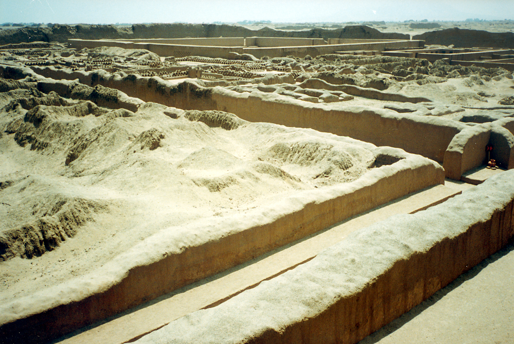

The coastal strip set the stage for the rise of many pre-Columbian cultures, such as the pre-Ceramic Huaca Prieta civilization, which is more than 5,000 years old & the Cupisnique, which is more than 3,000 years old. From 200 A.C., the first one to expand beyond its cradle was the Moche or Mochica culture. It was basically an agriculture and/or a warrior culture, which built countless temples and palaces such as the Sol (Sun), Luna (Moon), El Brujo & Cao Viejo, and other huacas. The Chimú culture emerged later and built its capital in Chan Chan, the largest pre-Columbian city in South America, & huacas like Esmeralda & Arco Iris (Rainbow). At its zenith, Chan Chan was home to 60,000 inhabitants who stubbornly resisted the expansion of the Inca Empire. These ancient cultures used irrigation canals and water reservoirs, which systems were increasingly better engineered and extensive over the years. The technological acumen of these sophisticated agricultural systems was carried into the Inca Empire, which surrounded the remnants of the prior cultures. The Spanish colonizers destroyed most of the agricultural works to more effectively establish political control and provide de facto slave labor from the displaced native agriculturalists.
The archaeological remains of Chan Chan, 6 km (3.7 mi) northeast of downtown Trujillo, are rather well-preserved despite being built out of adobe (mud bricks), largely because 1) dearth of rainfall and consequent erosion, and 2) lack of significant re-use of its construction materials (adobes do not respond easily to removal and transport and are relatively cheap to make on-site in current methods of construction).
During the Late Moche phase (AD 600 to 850), one of the largest power centers of the region was the fortified site of Cerro Chepén in the Jequetepeque Valley. It is located 3 km to the south of the site of San José de Moro.
Cerro Chepén has a sophisticated system of fortifications, and a dominant position on top of the hill, with many monumental buildings. Recent excavations at the site revealed that there was much internal conflict there that affected local communities.
Archeological sites
Some of the archeological sites in La Libertad Region are:
- Chan Chan
- El Brujo
- Huaca del Sol
- Huaca de la Luna
- Marcahuamachuco
- Pacatnamu
- Pirqa Pirqa
- San José de Moro
- Huaca Santa Clara
- Wiraquchapampa
- Archeological Complex Caballo Muerto
Places of interest
- Calipuy National Sanctuary
Ecological regions
Water supply and sanitation
The public company for water supply and sanitation in La Libertad Region is SEDALIB which is formed by shareholders of municipalities of the Region.
Culture
Festivals and events
- Spring Festival
- Marinera Festival
- International Calzaferia El Porvenir. It is a fair of footwear and in 2012 took place the 10th edition; it is held in El Porvenir city.
- Regional Fair of the Pineapple. It is held in the town of Poroto.
- Virgin of La Puerta. Patronal Feast; the celebration originated in 1664 when it placed the image of the Virgin at the entrance of Otuzco as precaution of the risk of a pirate raid. The main day is celebrated on December 15 every year and in 2012 the feast of Our Lady of the Gate was declared a National Cultural Heritage by the Peruvian government.
- Contradanza. Expression cultivated in Huamachuco city, in the villages Urpay, Shiracmaca and Culicanda. This dance in 2012 has been declared a National Cultural Heritage by the Peruvian government.
References
References
- Alva Castro, Luis. (2003). "Bolívar en La Libertad". Instituto Víctor Raúl Haya de la Torre.
- (2023-02-10). "202 AÑOS de la promulgación del REGLAMENTO PROVISIONAL expedida por GRAL. DON JOSE DE SAN MARTIN en la ciudad de HUAURA". [[Gob.pe]].
- Paredes Laos, Jorge. (2021-02-06). "El aniversario del manuscrito de Huaura, la primera constitución que tuvo el Perú". [[El Comercio (Peru).
- Kuong Cabello, Luis E.. (1982). "Retazos de la Historia de Moquegua". Universidad de Moquegua.
- "Reseña histórica".
- Alva Castro, Luis. (2004). "Bolívar en La Libertad". Universidad Andina Simón Bolívar, [[Andean Parliament.
- [https://web.archive.org/web/20190129235954/https://undiario.pe/2018/11/05/conozca-como-estaran-conformados-concejos-municipales-2019-2022-en-guadalupe-jequetepeque-y-san-jose UNDiario.pe]
- [http://sanjosedemoro.pucp.edu.pe/02english/01region.html San José de Moro Region.] SAN JOSÉ DE MORO Archaeological Program, Pontificia Universidad Católica del Perú
- Marco Rosas, [http://hdl.handle.net/1928/11001 Cerro Chepen and the Late Moche Collapse in the Jequetepeque Valley, North Coast of Peru] 2010
- "Trujillo: X Calzaferia llegó a su fin con éxito".
- "Trujillo: Relanzarán Feria Regional de la Piña en Poroto".
- "Fiesta de la Virgen de la Puerta fue declarada Patrimonio Cultural de la Nación".
- "Contradanza de Huamachuco ya es patrimonio de la Nación".
This article was imported from Wikipedia and is available under the Creative Commons Attribution-ShareAlike 4.0 License. Content has been adapted to SurfDoc format. Original contributors can be found on the article history page.
Ask Mako anything about Department of La Libertad — get instant answers, deeper analysis, and related topics.
Research with MakoFree with your Surf account
Create a free account to save articles, ask Mako questions, and organize your research.
Sign up freeThis content may have been generated or modified by AI. CloudSurf Software LLC is not responsible for the accuracy, completeness, or reliability of AI-generated content. Always verify important information from primary sources.
Report