From Surf Wiki (app.surf) — the open knowledge base
Deccan Plateau
Plateau on the Indian Subcontinent

Plateau on the Indian Subcontinent
| Field | Value |
|---|---|
| name | Deccan Plateau |
| settlement_type | Plateau |
| other_name | Peninsular Plateau |
| image_map | Deccan, India.png |
| map_caption | The Deccan Plateau (cyan) forms a major part of Deccan Peninsula |
| coordinates | |
| subdivision_type | Country |
| subdivision_name | India |
| subdivision_type2 | States |
| subdivision_name2 | Mostly: |
| Partially: | |
| area_total_km2 | 422,000 |
Partially:
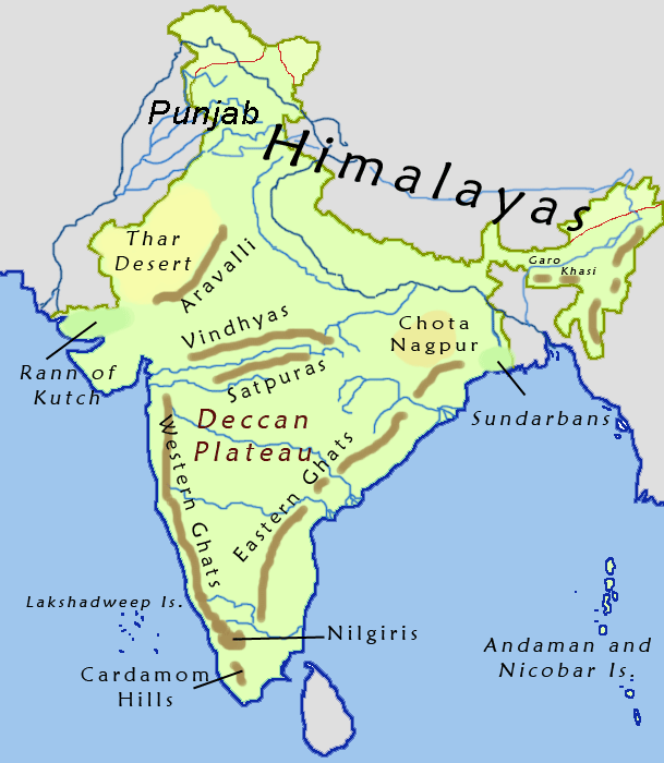
The Deccan Plateau ( ) or Peninsular Plateau, is a plateau that extends over an area of 422,000 km2 on the southern part of the Indian Subcontinent. The plateau forms the bulk of the Deccan Peninsula, and stretches from the Satpura and Vindhya ranges in the north to the northern fringes of Tamil Nadu in the south. It is bound by the mountain ranges of the Eastern Ghats and the Western Ghats on the sides, which separate the region from the Eastern and Western coastal plains respectively. The plateau covers most of the Indian states of Andhra Pradesh, Karnataka, Maharashtra, and Telangana, excluding the coastal regions, and minor portions of Kerala and Tamil Nadu.
The plateau is marked by rocky terrain with an average elevation of about 600 m. It is subdivided into Maharashtra Plateau, Karnataka Plateau, and Rayalaseema and Telangana Plateau. The Deccan Traps in the northwest were formed by multiple layers of igneous rock deposited by basaltic lava flows following a massive volcanic eruption occurred at the end of the Cretaceous period (66 mya). The underlying bed consists of granite and sedimentary rocks formed during the Precambrian era and the formation of Gondwana.
The region forms one of the major watersheds of India, with many perennial river systems such as Godavari, Krishna, and Kaveri flowing through the region. The plateau slopes gently from the west to east, resulting in most of the principal rivers flowing eastwards towards the Bay of Bengal. As the Western Ghats block the rain bearing winds, the plateau region is drier than the coastal region and has a semi-arid climate.
The Deccan Plateau region was ruled by several kingdoms in Indian history such as Pallavas, Cholas, Pandyas, Satavahanas, Chalukyas, Rashtrakutas, Hoysalas, Kadambas, Kakatiyas, and Western Gangas. In the later medieval era, the lower plateau was ruled by the Vijayanagara Empire, and the upper portion by the Bahmani Kingdom, and its successors, the Deccan sultanates. It later housed the Kingdom of Mysore, Maratha Confederacy, and Nizam's dominions. It was under the control of British Raj for nearly two centuries before Indian independence in 1947. The reorganisation of Indian states in the 1950s resulted in the creation of states on linguistic lines.
Etymology
The word Deccan is an anglicised version of the Prakrit word **, which evolved from the Sanskrit word dakṣiṇa, meaning "south".
History
Carbon dating shows that ash mounds associated with Neolithic cultures in region date back to 8000 BCE. Towards the beginning of 1000 BCE, iron technology spread through the region though geological evidence does not point to a fully developed Bronze Age in existence prior to the Iron Age. Since at least the 1st century BCE, the region was connected to the Silk Road and was involved in trade with the Mediterranean and East Asia.
Several dynasties such as the Pandyas of Madurai, the Cholas of Thanjavur, the Zamorins of Kozhikode, the Satavahanas of Amaravati, the Pallavas of Kanchi, the Kadambas of Banavasi, the Western Gangas of Kolar, the Rashtrakutas of Manyakheta, the Chalukyas of Badami, the Hoysalas of Belur, and the Kakatiyas of Orugallu ruled over the region from the 6th century BCE to the 14th century CE. In the Late Middle Ages, Vijayanagara empire conquered most of the southern part of the pleateu region. The upper portion was ruled by the Bahmani kingdom, and later by its successors, the Deccan sultanates.
The Europeans arrived in the 15th century CE and by the middle of the 18th century, the French and the British were involved in a protracted struggle for military control over the region. The Maratha Empire founded by Chatrapati Shivaji, briefly captured the region in the early 18th century CE. After the defeat of Mysore Kingdom in the late 18th century CE and the Vellore Mutiny in 1806 CE, the British East India Company consolidated their power over much of the region. The British Empire took control of the region from the British East India Company in 1857.
During the British colonial rule, the region was divided between the Madras Presidency, Bombay Presidency, Hyderabad State, and Mysore. The region played a major role in the Indian independence movement. After Indian Independence in 1947, majority of the region was organised into four states Bombay State, Hyderabad State, Madras State, and Mysore State. The Reorganisation of Indian states on linguistic lines in the 1950s resulted in the creation of the states of Andhra Pradesh, Karnataka, Kerala, Maharashtra, and Tamil Nadu. Telangana was created in 2014 by bifurcating Andhra Pradesh.
Geology


The Deccan Plateau is one of the oldest and most stable land formations in the Indian subcontinent. The plateau is marked by rocky terrain with an average of about 600 m (2,000 ft). The Deccan Traps consist of multiple layers of igneous rocks, which are more than 2 km in thickness. These rocks were laid down by basaltic lava flows which emerged from deep inside the Earth's crust following a massive volcanic eruption.
The eruption event occurred during the end of the Cretaceous period (66 mya) and is the second largest volcanic eruption ever recorded on land. Scientists state that the volcanic event would have released large amounts of ash, dust and carbon dioxide into the atmosphere. The release would have blocked sunlight resulting in lower temperatures and caused major climatic changes on Earth. The eruption would have resulted in high levels of sulfur, chlorine and other toxic gases in the atmosphere. Researchers argue that the volcanic event would have contributed to the extinction of various species including some of the dinosaurs.
The volcanic deposits stretch more than 500000 km2 encompassing neighbouring central highlands. The deposits consist of three subgroups based on the time and level of deposition. Underlying the lava deposits are granite and sedimentary rocks formed during the Precambrian era and the formation of Gondwanaland. The Indo-Gangetic Plain rests on hard crystalline rocks which connect the Himalayan region with the plateau region. Apart from granite, parts of the region consists of metamorphic rocks such as gneiss, and schist.
The Deccan Plateau region is rich in mineral deposits like iron ore, coal, and mica. Precious and semi precious stones have also been mined from the region. Large uranium deposits have been discovered in the region in the 21st century. There are two major soil types, forming distinct sub-regions of the plateau. Most of the region with igneous basaltic rock consists of black soil. These soils have a high clay content, retain moisture and are resistant to erosion, but develop cracks during the dry season. The gneiss peneplain region in the low rainfall areas in the eastern vicinity of the Western Ghats consist of infertile red soil.
Geography
Historians have used the term Deccan differently across various time periods. Firishta (16th century), R. G. Bhandarkar (1920), and Richard Eaton (2005) demarcate the region based on linguistic lines. K. M. Panikkar (1969) defines it as the entire Indian peninsula south of the Vindhyas. Stewart Gordon (1998) notes that Deccan is a "relational term" and historically the border of Deccan has varied from Tapti River to the Godavari River, depending on the southern boundary of the northern empires and is used to denote "the area beyond the southern border of a northern-based kingdom" of India.
Geographers have defined the extent of Deccan region using various physical features and indices such as rainfall, vegetation, or soil type. As per a broader geographical definition, the region consists of the peninsular tableland lying to the south of the Tropic of Cancer, marked by the Vindhya-Satpura ranges in the north. The Deccan is a plateau region extending over an area of 422000 km2 and occupies the majority of the Indian peninsula. It is shaped like an inverted triangle with its upper boundary at the Narmada River basin near the Vindhya-Satpura ranges and the lower boundary at the northern fringes of Tamil Nadu in the south.
The region is bound by the mountain ranges of the Western Ghats and the Eastern Ghats on the sides, which separate the region from the Western and Eastern Coastal Plains respectively. It covers most of the Indian states of Maharashtra, Telangana, Karnataka and Andhra Pradesh excluding the coastal regions, and minor portions of Tamil Nadu and Kerala. The western side of the plateau is elevated gently slopes towards the east. It is subdivided into Maharashtra Plateau, Karnataka Plateau, and Telangana Plateau.
Hydrography and climate

The Deccan forms one of the major watersheds of India, feeding many perennial rivers. The major river systems originating in the Western Ghats are the Godavari, Kaveri, and Krishna. Most rivers flow eastwards towards the Bay of Bengal owing to the steeper gradient moving from east to west, with only smaller streams flowing in the opposite direction. The streams and rivers give rise to numerous waterfalls in the region. The rivers have been dammed for hydroelectric and irrigation purposes, with major reservoirs spread across the region.
The region has largely semi-arid climate in the northern parts and tropical climate in most of the other areas. The summer months of AprilMay are dry and hot with maximum temperatures often rising more than 40 °C. During the dry summer months of AprilMay, heat builds up on the interior of the Deccan Plateau, which draws air from the sea. The air, which picks up moisture along the way and flows eastward from the Arabian Sea, is blocked by the Western Ghats. The rising air cools and brings about orographic precipitation along the western coast, which signifies the onset of the monsoon season in June.
By the time the air rises above the mountains, it becomes dry, resulting in a rain shadow region with very little rainfall on the leeward side towards the interior of the Deccan plateau. The monsoon winds rounding up the peninsula and moving from the east from the Bay of Bengal pass over the Eastern Ghats and bring some rainfall to the eastern region of the plateau. The region receives most of the rainfall during the months of July to September and the rains feed the rivers that flow into basins and then into the Bay of Bengal.
Flora and fauna
There is a wide diversity of plants and animals in the region, resulting from its varied climates and geography. scrub lands are common in the low rainfall regions with dry deciduous forests found in the southern part of the plateau. The woodlands of the region are older than the Himalayas. The central part of the plateau is covered by woodlands formed by trees such as hardwickia, teak, siris, axlewood, boswellia, and acacia trees. The region hosts significant populations of endangered Bengal tigers and Indian elephants Other mammals found in the region include gaur, blackbuck, chinkara, four-horned antelope, wild buffalo, and Indian wild dog.
Demographics

The largest linguistic group in the region is the Dravidian family of languages, of approximately 73 languages. The Telugus and Kannadigas who speak Telugu and Kannada form the major demographic groups in the central region. Tamils and Malayalis form a part of the southern end of the plateau. Marathi people, who speak Marathi, an Indo-Aryan language, form the majority in the north-western part of the plateau. English is also widely spoken in urban areas of the region. Deccani Urdu a regional dialect of Urdu is spoken by the Muslims.
Evidence of prehistoric religion in the region comes from scattered Mesolithic rock paintings depicting dances and rituals, such as the Kupgal petroglyphs of eastern Karnataka, at Stone Age sites. Hinduism is the major religion today in the region.
The total fertility rate in the region was less than the population replacement level and as a result, the proportion of the population of the region to India's total population has declined in the last four decades. The economies of the states in the region registered a growth higher than the national average over the past three decades. While the states have improved in some of the socio-economic metrics, there is wide disparity within the region.
Economy
Agriculture is often difficult in low rainfall areas, which require additional irrigation facilities while it is more feasible in the river valleys. Agriculture is still the primary occupation in the region. Rice is the staple food and major crop in the region. Others crops cultivated include sugarcane, banana, cotton, turmeric, millets, pulses, and spices. The urban centres are significant contributors to the Indian and global Information Technology economy. The presence of these hubs has spurred economic growth and attracted foreign investments and job seekers from other parts of the country. Manufacturing and textiles are other major industries in the region.
Culture
.jpg)
As defined by Ministry of Culture of the Government of India to promote and preserve the cultural heritage, the region falls under the purview of West and South Zone Cultural Centers. The women traditionally wear a sari, a garment that consists of a drape varying from 5 yd to 9 yd in length and 2 ft to 4 ft in breadth that is typically wrapped around the waist, with one end draped over the shoulder, baring the midriff, as according to Indian philosophy, the navel is considered as the source of life and creativity. The men wear a dhoti, a 4.5 m long, white rectangular piece of non-stitched cloth often bordered in brightly coloured stripes. It is usually wrapped around the waist and the legs and knotted at the waist. A colourful lungi with typical batik patterns is the most common form of male attire in the countryside. People in urban areas generally wear tailored clothing, and western dress is popular. Western-style school uniforms are worn by both boys and girls in schools, even in rural areas.
The region has a rich cuisine involving both traditional non-vegetarian and vegetarian dishes. The traditional way of eating a meal involves eating food served on a banana leaf using the right hand. Rice is the staple food in meals of the region. Bhakri made of millets and roti or chapathi made of wheat served with dal are popular in the north and western parts of the region. Idli and dosa served with sambar and chutney for breakfast and rice served with sambar and rasam for lunch are popular in the eastern and southern parts of the region. Hyderabadi cuisine is popular for its biryani.
The region is home to various music and dance forms such as Kuchipudi, Lavani, Yakshagana, and Bharatanatyam. There are three distinct styles of rock architecture, the Dravidian style of Tamil Nadu, Andhra Pradesh, the Vesara style of Karnataka, Telangana, and the Nagara style of Maharashtra. In Dravidian architecture, the temples considered of large gate-pyramids or Gopurams in quadrangular enclosures that surround the temple with large pillared halls. Vimanam are similar structures built over the garbhagriha or inner sanctum of the temple but are usually smaller than the gopurams in the Dravidian architecture. In the Nagara style, the temples had one or more shikharas, which are towers similar to the vimanas. The Vesara style is a hybrid of both these architectural styles.
Transport

There is an extensive road network composed of National Highways, State Highways and other roads in the region. The Golden Quadrilateral connecting the major cities in the country traverses across the region. Public bus services are mostly provided by state-run transport corporations.
The Madras Railway was established in 1845 and the Great Indian Peninsular Railway was incorporated in 1849. The construction on the first main line in the South between Royapuram in Madras and Arcot started in 1853, which became operational on 1 July 1856. In 1879, the Nizam's Guaranteed State Railway was established which built railway lines across the then Hyderabad State and the Mysore State Railway was established to build an extension of Madras Railway in Mysore State. In 1880, the Great Indian Peninsula Railway built a railway network radiating from Madras. The Madras and Southern Mahratta Railway was founded on 1 January 1908 by merging the Madras Railway and the Southern Mahratta Railway. In 1950, there were about 42 different railway companies across the countrym which were amalgamated in steps to form a single entity named as Indian Railways. On 14 April 1951, the Madras and Southern Mahratta Railway, the South Indian Railway, and the Mysore State Railway were merged to form the Southern Railway, the first zone of Indian Railways. The Western was established on 5 November 1951, the South Central zone on 2 October 1966, and the South Western zone on 1 April 2003. Most of the region is covered by these four zones, with small portions of the coasts covered by East Coast Railway and Konkan Railway. Metro and suburban systems are operational in major cities.
Air transport in the region started in the late 1910s with commercial services beginning in the 1930s. The region has multiple international and domestic airports. Chennai International Airport serves as the Southern Regional Headquarters of the Airports Authority of India, the Southern Region comprising the states of Andhra Pradesh, Karnataka, Kerala, Tamil Nadu, and Telangana, and Mumbai International Airport serves the state of Maharashtra. The southern region comes under the purview of the Southern Air Command of the Indian Air Force and the north western region comes under the South Western Air Command.
References
References
- (13 June 2013). "Hobson-Jobson: The Definitive Glossary of British India". [[Oxford University Press]].
- Turner, R. L.. (30 October 1966). "A comparative dictionary of Indo-Aryan languages". [[Oxford University Press]].
- "Monier-Williams Sanskrit-English Dictionary". [[Monier-Williams]].
- Agarwal, D.P. (2006). "Urban Origins in India". Uppsala University.
- Schoff, Wilfred. (1912). "The Periplus of the Erythraean Sea: Travel And Trade In The Indian Ocean By A Merchant Of The First Century". South Asia Books.
- J. Innes, Miller. (1998). "The Spice Trade of The Roman Empire: 29 B.C. to A.D. 641". [[Oxford University Press]].
- Elisseeff, Vadime. (2001). "The Silk Roads: Highways of Culture and Commerce". [[Berghahn Books]].
- Sastri, Nilakanta. (1976). "A History of South India from Prehistoric Times to the Fall of Vijayanagar". [[Oxford University Press]].
- "Deccan".
- George C. Kohn. (2006). "Dictionary of Wars". Infobase Publishing.
- Jenkins, Everett. (2015). "The Muslim Diaspora (Volume 1, 570–1500): A Comprehensive Chronology of the Spread of Islam in Asia, Africa, Europe and the Americas, Volume 1". [[McFarland & Company.
- Wink, André. (2020). "The Making of the Indo-Islamic World C.700–1800 CE". [[Cambridge University Press]].
- (1999). "Architecture and Art of the Deccan Sultanates (The New Cambridge History of India Vol. I:7)". Cambridge University Press.
- Tucker, Spencer C.. (2010). "A global chronology of conflict". [[ABC-Clio]].
- Pearson, M.N.. (February 1976). "Shivaji and the Decline of the Mughal Empire". The Journal of Asian Studies.
- Capper, J.. (1918). "Delhi, the Capital of India". [[Asian Educational Services]].
- Sen, S.N.. (2010). "An Advanced History of Modern India". [[Macmillan Publishers]].
- Hibbert, Christopher. (1 March 2000). "Great Mutiny: India 1857". [[Penguin Publishing]].
- "India". World Digital Library.
- (1909). "Imperial Gazetteer of India vol. IV". [[University of Chicago]].
- (22 September 2009). "Indian National Evolution: A Brief Survey of the Origin and Progress of the Indian National Congress and the Growth of Indian Nationalism". [[Cornell University Press]].
- "Constitution of India". [[Government of India]].
- Thapar, Romesh. (1978). "Change and Conflict in India". [[Macmillan Publishers]].
- "States Reorganisation Act, 1956". High Court of Tripura.
- (15 October 1955). "Reorganisation of states". Economic Weekly.
- "The Andhra Pradesh Reorganisation Act, 2014". [[Government of India]].
- (20 February 2014). "Telangana bill passed by upper house". [[The Times of India]].
- (28 June 2021). "Deccan Plateau". World Atlas.
- "Deccan Traps". [[American Museum of Natural History]].
- "Petrophysical properties of the entire Deccan basalt stratigraphy". [[Council of Scientific and Industrial Research]].
- "Indo Gangetic Plain". [[University Grants Commission (India).
- "The Deccan".
- Ottens, Berthold. (1 January 2003). "Minerals of the Deccan Traps, India". HighBeam Research.
- Subramanian, T. S.. (20 March 2011). "Massive uranium deposits found in Andhra Pradesh". [[The Hindu]].
- Thakur, Monami. (19 July 2011). "Massive uranium deposits found in Andhra Pradesh". International Business Times.
- Bedi, Rahul. (19 July 2011). "Largest uranium reserves found in India". [[The Telegraph (India).
- Alam, Shah Manzoor. (2011). "Urban Growth Theories and Settlement Systems of India". Concept.
- Gordon, Stewart. (1993). "The Marathas 1600–1818". [[Cambridge University Press]].
- Eaton, Richard M.. (2005). "A Social History of the Deccan, 1300–1761". [[Cambridge University Press]].
- (9 September 2008). "Physiography of Water". [[Press Information Bureau]].
- (1982). "Population of India". Economic and Social Commission for Asia and the Pacific, United Nations.
- (1981). "Paleogeography, 180 million years ago to the present". Eclogae Geologicae Helvetiae.
- "Formation of Western Ghats". Indian Institute of Science.
- (2016). "Western Ghats - From Ecology To Economics". Educreation Publishing.
- Dhruv Sen Singh. (2017). "The Indian Rivers: Scientific and Socio-economic Aspects". [[Springer Nature]].
- Patricia Corrigan. (2019). "Waterfalls". Infobase Publishing.
- "Indian Dams by River and State". Rain water harvesting.
- (2002). "Silting Problems in Hydropower Plants". Central Board of Irrigation and Power.
- "Indian monsoon". Britannica.
- "Orographic precipitation". Britannica.
- "Climate of Western Ghats". Indian Institute of Science.
- "The Deccan Peninsula". Sanctuary Asia.
- "Eastern Deccan Plateau Moist Forests". [[World Wildlife Fund]].
- "Indo-Malayan Terrestrial Ecoregions".
- (15 January 2015). "India's tiger population rises". [[Deccan Chronicle]].
- (2007). "Elephant Census 2005". [[Government of India]].
- Caldwell, Robert. (1998). "A comparative grammar of the Dravidian or South-Indian family of languages". Asian Educational Services.
- "Statement 1 : Abstract of speakers' strength of languages and mother tongues – 2011". [[Government of India]].
- Baldridge, Jason. "Linguistic and Social Characteristics of Indian English". University of Edinburgh.
- "Religious statistics, Census 2011". [[Government of India]].
- Fatihi, A.R.. "Urdu in Andhra Pradesh". Language in India.
- Upadhyaya, Padmanabha. (1973). "Coastal Karnataka: Studies in Folkloristic and Linguistic Traditions of Dakshina Kannada Region of the Western Coast of India". Govind Pai Samshodhana Kendra.
- (19 March 2004). "Ancient Indians made 'rock music'". [[BBC News]].
- Webster, Merriam. (1999). "Encyclopedia of World Religions". Merriam-Webster.
- "Religion, Census of India". Government of India.
- (2003). "The surprising global variation in replacement fertility". Population Research and Policy Review.
- (7 July 2011). "Maternal & Child Mortality and Total Fertility Rates". Office of Registrar General.
- Ishtiaq, M.. (1999). "Language Shifts Among the Scheduled Tribes in India: A Geographical Study". Motilal Banarsidass.
- (1991). "Comparative Speaker's Strength of Scheduled Languages – 1971, 1981, 1991 and 2001". Census of India.
- (20 April 2015). "Human development, poverty, health & nutrition situation in India". Council of Social Development, Southern Regional Centre & Division of Community Studies National Institute of Nutrition (ICMR).
- (16 July 2007). "Also A Head For Numbers". [[Outlook (Indian magazine).
- Guha, Ramachandra. (22 July 2015). "The Better Half". [[Outlook (Indian magazine).
- (September 1995). "Peninsular India". Photius.
- "Agricultural Statistics at a Glance 2021". [[Government of India]].
- "Distribution of workers by category of workers, Census 2011". Government of India.
- "Food Staple". [[National Geographic Society]].
- (29 December 2009). "Turmeric at an all-time high price". [[The Economic Times]].
- "Sugracane in India". [[Government of India]].
- "State wise major spice production". [[Government of India]].
- Canton, Naomi. (6 December 2012). "How the 'Silicon Valley of India' is bridging the digital divide". CNN.
- Rai, Saritha. (20 March 2006). "Is the Next Silicon Valley Taking Root in Bangalore?". [[The New York Times]].
- Vaidyanathan, Rajini. (5 November 2012). "Can the 'American Dream' be reversed in India?". [[BBC World News]].
- (1 December 2012). "Maharashtra tops FDI equity inflows". [[Business Standard]].
- Subramanyam Javvadi. "Eight auto majors are looking at Andhra Pradesh as their base for operations". Autocar.
- "India's Gems and Jewellery Market is Glittering". Resource Investor.
- (17 April 2014). "Lok Sabha Elections 2014: Erode has potential to become a textile heaven says Narendra Modi". DNA India.
- (7 August 2014). "State wise number of Textile Mills". Press Information Bureau, Government of India.
- "Zonal Cultural Centers". [[Ministry of Culture (India).
- Boulanger, Chantal. (1997). "Saris: An Illustrated Guide to the Indian Art of Draping". Shakti Press International.
- Lynton, Linda. (1995). "The Sari". Harry N. Abrams, Incorporated.
- (2001). "Sociology of Religion". Prentice Hall.
- "About Dhoti".
- "Clothing in India".
- Czarra, Fred. (2009). "Spices: A Global History". Reaktion Books.
- Dalby, Andrew. (2002). "Dangerous Tastes: The Story of Spices". Berkeley: University of California Press.
- (2000). "Advancing banana and plantain R & D in Asia and the Pacific". Biodiversity International.
- Kalman, Bobbie. (2009). "India: The Culture". Crabtree Publishing Company.
- "Food Balance Sheets and Crops Primary Equivalent". [[FAO]].
- (2004). ["Maharashtra"]({{google books). Popular Prakashan.
- Achaya, K.T.. (1 November 2003). "The Story of Our Food". Universities Press.
- Balasubramanian, D.. (21 October 2014). "Changes in the Indian menu over the ages". [[The Hindu]].
- (2023). "The Bloomsbury Handbook of Indian Cuisine". [[Bloomsbury Publishing]].
- (26 May 2003). "Varieties from Chettinad cuisine". [[The Hindu]].
- (13 January 2013). "The music of we primates:Nada Brahmam". [[The Hindu]].
- Massey, Reginald. (2004). "India's Dances Their History, Technique, and Repertoire". Abhinav.
- Samson, Leela. (1987). "Rhythm in Joy: Classical Indian Dance Traditions". Lustre Press.
- Harman, William P.. (9 October 1992). "The sacred marriage of a Hindu goddess". [[Motilal Banarsidass]].
- Fergusson, James. (1997). "History of Indian and Eastern Architecture". Low Price Publications.
- Ching, Francis D.K.. (2007). "A Global History of Architecture". John Wiley and Sons.
- Ching, Francis D.K.. (1995). "A Visual Dictionary of Architecture". John Wiley and Sons.
- S.R. Balasubrahmanyam. (1975). "Middle Chola Temples". Thomson Press.
- (April 2016). "Vimana architecture under the Cholas". Shanlax International Journal of Arts, Science & Humanities.
- "Shikhara".
- Sinha, A.J.. (2000). "Imagining Architects: Creativity in the Religious Monuments of India". University of Delaware Press.
- (2001). "New Light on Hampi, Recent research in Vijayanagara". MARG.
- "Year at a glance". [[Government of India]].
- "Profile, APSRTC". Government of Andhra Pradesh.
- "About TNSTC". Government of Tamil Nadu.
- "History of KSRTC". Government of Karnataka.
- Krishnamoorthy, Suresh. (16 May 2014). "It will be TGSRTC from June 2". [[The Hindu]].
- (31 March 2013). "On Forgotten Road". [[The Times of India]].
- "The History of Nizam's Railways System". Lulu.com.
- Rungta, Shyam. (1970). "The Rise of Business Corporations in India, 1851–1900". Cambridge U.P..
- "Origin and development of Southern Railway". [[Indian Railways]].
- (1982). "The Cambridge Economic History of India, Vol 2". Orient Blackswan.
- "Third oldest railway station in country set to turn 156". Indian Railways.
- "Indian Railways". [[Parliament of India]].
- "Modernisation booklet". [[Indian Railways]].
- "Evolution of Indian Railways-Historical Background". Ministry of Railways.
- "Overview of Indian Railways". National Academy of Indian Railways.
- "Zones and divisions of Indian Railways". Indian Railways.
- "Metro rail transport". [[Government of India]].
- Sood, Jyotika. (26 July 2017). "How metro rail networks are spreading across India". [[Live mint]].
- (25 January 2011). "100 years of Civil Aviation". [[Government of India]].
- Higham, Robin. (1961). "Britain's Imperial Air Routes, 1918 to 1939". Shoe String Press.
- (1953). "De Havilland Gazette". De Havilland Aircraft Company.
- "List of Indian Airports". [[Airports Authority of India]].
- "Traffic Statistics-July 2024". [[Airports Authority of India]].
- "Regional Headquarters of AAI". [[Airports Authority of India]].
- "Indian Air Force Commands". [[Indian Air Force]].
This article was imported from Wikipedia and is available under the Creative Commons Attribution-ShareAlike 4.0 License. Content has been adapted to SurfDoc format. Original contributors can be found on the article history page.
Ask Mako anything about Deccan Plateau — get instant answers, deeper analysis, and related topics.
Research with MakoFree with your Surf account
Create a free account to save articles, ask Mako questions, and organize your research.
Sign up freeThis content may have been generated or modified by AI. CloudSurf Software LLC is not responsible for the accuracy, completeness, or reliability of AI-generated content. Always verify important information from primary sources.
Report