From Surf Wiki (app.surf) — the open knowledge base
Darnestown, Maryland
Census-designated place in the United States

Census-designated place in the United States
| Field | Value |
|---|---|
| name | Darnestown, Maryland |
| settlement_type | Census-designated place |
| image_skyline | Darnestown, Maryland welcome sign.jpg |
| image_map | Montgomery_County_Maryland_Incorporated_and_Unincorporated_areas_Darnestown_Highlighted.svg |
| mapsize | 250x200px |
| map_caption | Location of Darnestown, Maryland |
| subdivision_type | Country |
| subdivision_type1 | State |
| subdivision_type2 | County |
| subdivision_name | United States |
| subdivision_name1 | Maryland |
| subdivision_name2 | Flag_of_Montgomery_County,_Maryland.svg Montgomery |
| unit_pref | Imperial |
| area_total_sq_mi | 17.70 |
| area_land_sq_mi | 16.39 |
| area_water_sq_mi | 1.31 |
| population_as_of | 2020 |
| population_total | 6723 |
| population_density_sq_mi | auto |
| timezone | Eastern (EST) |
| utc_offset | −5 |
| timezone_DST | EDT |
| utc_offset_DST | −4 |
| elevation_footnotes | |
| elevation_ft | 374 |
| coordinates | |
| postal_code_type | ZIP codes |
| postal_code | 20878, 20874, 20834 |
| area_codes | 301, 240 |
| blank_name | FIPS code |
| blank_info | 24-21825 |
| blank1_name | GNIS feature ID |
| blank1_info | 2389395 |
| website | https://darnestowncivic.org/ |
| footnotes | 2389395 |
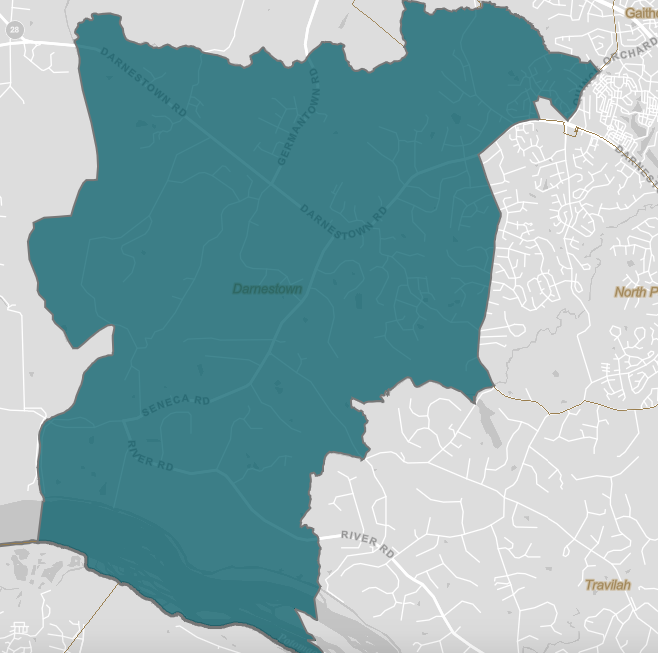
Darnestown is a United States census-designated place (CDP) and an unincorporated area in Montgomery County, Maryland. The CDP is 17.70 sqmi with the Potomac River as its southern border and the Muddy Branch as much of its eastern border. Seneca Creek borders portions of its north and west sides. The Travilah, North Potomac, and Germantown census-designated places are adjacent to it, as is the city of Gaithersburg. Land area for the CDP is 16.39 sqmi. As of the 2020 census, the Darnestown CDP had a population of 6,723, while the village of Darnestown is considerably smaller in size and population. Downtown Washington, D.C. is about 22 mi to the southeast.
Within the Darnestown census-designated place at the intersection of what is now Darnestown Road and Seneca Road, the small village of Darnestown has existed since about 1800. The community had a population of 200 in 1878. The name Darnestown comes from William Darne, who owned the most land in the area at the beginning of the 19th century when the community post office opened. Settlement in the area began around 1750, and the tiny community was called Mount Pleasant, and then Darnes, before the name Darnestown began being used. The community thrived in the 19th century during the golden years of the Chesapeake and Ohio Canal, as the improved transportation facilities offered area farmers access to more markets. In the 1880 census, the United States Census Bureau began using a Minor Civil Division (MCD) category for aggregating populations, and the new Darnestown district had about 1,500 people. Growth stopped late in the 19th century when a new railway bypassed the community.
In the 1960s, affluent families began buying Montgomery County farmland for new housing and equestrian purposes. Today, many Darnestown CDP residents are wealthy and live in large homes on large lots, which is reflected in their high average income and low housing density. The median household income is nearly $228,000, and 73 percent of residents aged 25 years or more have at least a bachelor's degree or higher. The community benefits from its proximity to workplaces such as the Shady Grove Hospital area and the I-270 Technology Corridor. Washington is accessible by automobile or public transportation. Beginning with the 2000 census, the Census Bureau created a Darnestown census-designated place.
History
The first European (mostly Scottish and English) settlements in what would become Montgomery County, Maryland, were established in 1688, near Rock Creek and what was to become Rockville. The next stage of settlements was further west along the Potomac River near what is now Darnestown and Poolesville. The land had been occupied by Native Americans of the Piscataway Confederation. Ninian Beall was the first European landowner in the Darnestown area, settling around 1749.{{cite web |access-date=2020-03-30}} His daughter Ruth Beall married Charles Gassaway, who built a brick home named Pleasant Hills around 1765. This was one of the first brick homes in what is now Montgomery County, and still stands today.{{cite web |access-date=2020-08-12}} Gassaway purchased land from his father-in-law during the late 1700s—including land that would eventually become the Darnestown village. In the last half of the 18th century, a small village grew at the intersection of what is now Darnestown Road (Maryland Route 28) and Seneca Road (Maryland Route 112). At that time, Darnestown Road was called "the road from Georgetown to the mouth of the Monocacy River".{{cite web |access-date=2020-08-11}} It was a Seneca Indian trail and is one of the oldest roads in Montgomery County. Seneca Road led from Darnestown to the Seneca Mill and a landing on the Potomac River—a trip of less than 4 mi.
Gassaway's daughter Elizabeth married William Darne in 1798. Darne was a civic leader who served in the Maryland House of Delegates, as a judge, and as director of the Chesapeake and Ohio Canal. He also became one of the area's biggest landowners.{{cite web |access-date=2020-08-10}} The community was called Mount Pleasant until the establishment of a post office around 1803, when it gradually began being called "Darnes" in honor of its leading citizen.{{cite web |access-date=2020-08-11}}{{#tag:ref|A post office called "Darnes" is listed in an 1803 post office directory. Another post office source uses 1804 as the start date for the Darnes Post Office. (To find United States Post Office start and end dates for Darnestown, go to the Postmaster Finder web site and select Maryland from the drop-down box. Click Search to process.{{cite web |access-date=2020-08-10 |archive-date=October 17, 2020 |archive-url=https://web.archive.org/web/20201017165939/https://webpmt.usps.gov/pmt010.cfm |url-status=dead |access-date=2020-08-11 |access-date=2020-08-11}} An 1828 post office directory lists a Darnestown Post Office.|group=Note}} Darnestown's first store was kept by John Candler, and he is also cited as its first postmaster. Leonard W. Candler was the Darnestown postmaster as early as 1828, and he was still listed as such in 1850 when Darnestown was one of 15 post offices in Montgomery County. By the 1820s, the community had a wheelwright, mill, blacksmith, physician, and other businesses.{{cite web |access-date=2020-12-06}}--
Originally, Darnestown area land was used by European settlers for growing tobacco and corn. Construction of the Chesapeake and Ohio Canal (a.k.a. C&O Canal), which was operating between Georgetown and Seneca by June 1832, provided farmers with better access to markets. A network of roads and mills grew to connect farmers with the canal. Mills in the area included the Seneca Mill (circa 1780), Black Rock Mill (built in 1815), and the DuFief Mill (established 1850). Darne died in 1845, and his farm was eventually given to his son Alexander. By 1860, farmers were growing corn, wheat and oats. At the beginning of the American Civil War, Union Army leadership realized that the Potomac River area near Seneca was a possible crossing point for a Confederate invasion that could include Washington. The Darnestown area was occupied during 1861 by 18,000 Union troops. About halfway between the canal and Darnestown, Major General Nathaniel P. Banks kept his headquarters at the Samuel Thomas Magruder farm where the Potomac River could be observed from high ground. Troops from the 13th Massachusetts Infantry Regiment occupied the Pleasant Hills home originally built by the Gassaways. After the war, Darnestown continued to be a farming community. An 1879 atlas lists 19 of 22 Darnestown "patrons" as farmers.
In the 1870s, Darnestown's favorable transportation location suffered two setbacks that would affect future growth. First, freight traffic on the C&O Canal peaked in 1871, starting a downward trend that would end with the canal closing permanently in 1924.{{cite web |archive-url=https://web.archive.org/web/20071012102036/http://www.nps.gov/nr/travel/wash/dc6.htm |url-status=dead |archive-date=October 12, 2007 |access-date=2020-07-07}} Second, the Baltimore and Ohio Railroad's new Metropolitan Branch opened in 1873 and bypassed Darnestown—running through Rockville, Gaithersburg, and Germantown.{{cite web |access-date=2020-08-20}} These factors limited growth for Darnestown, as nearby communities on the new rail line had "unprecedented facilities" for "personal travel and transportation of productions and supplies".{{cite web |access-date=2020-08-27}}-- The Darnestown Post Office, which had been operating for over 100 years, was discontinued May 31, 1911.{{#tag:ref|To find United States Post Office start and end dates for Darnestown, go to the Postmaster Finder web site and select Maryland from the drop-down box. Click Search to process.{{cite web |access-date=2020-08-10 |archive-date=October 17, 2020 |archive-url=https://web.archive.org/web/20201017165939/https://webpmt.usps.gov/pmt010.cfm |url-status=dead |access-date=2020-08-27}} The Seneca school closed in 1910. In 1918, the Travilah Hall Company defaulted on its mortgage for the community's town hall.{{cite web |access-date=2020-08-27}}|group=Note}} Darnestown grew very little until the 1960s, when wealthy families began buying farmland for living quarters and horseback riding. From 1970 to 1976, the population along Maryland Route 28 from Rockville to Darnestown nearly tripled.{{cite news |access-date=2020-08-28
Historic places
![old white church]][[Image:Black Rock Mill entrance.jpg](https://upload.wikimedia.org/wikipedia/commons/2/20/Darnestown_Presbyterian_Church_old_part.jpg)
The cornerstone for the Darnestown Presbyterian Church was laid on September 14, 1856, by a congregation organized in 1855. John L. DuFief, a community leader and owner of the DuFief Mill, donated 3 acres of land for the church. The completed structure was dedicated on May 22, 1858. The building was expanded in the late 1890s, and a bell tower was added at that time. Stained glass windows were installed in 1905, and a rear wing was added in the 1950s. The church's cemetery contains the graves of some of the area's early settlers, including members of the Darne, Clagett, Offutt and Tschiffely families; Chesapeake and Ohio Canal lock keepers Pennifield, Violette, and Riley; and philanthropist Andrew Small. Small's donation of $40,000 () became the Andrew Small Academy, and its building was said to be the largest school house in the country at the time of its construction in 1869. The three-story building became a public high school in 1907, and was demolished in 1955 when the present-day Darnestown Elementary School was built.{{cite web |access-date=2020-07-26}}
Additional historic places include Black Rock Mill, located in Seneca Creek State Park.{{cite web |access-date=2020-05-16}} The mill began operating in 1815, was run by Nicholas Offutt (a grandson of Ninian Beall) from 1866 until 1891, and continued operating into the 20th century.{{cite web |access-date=2020-05-16}}{{cite web |access-date=2020-05-09}} The Samuel Thomas Magruder farmhouse, now privately owned, was headquarters for Major General Nathaniel P. Banks in 1861 during the American Civil War.{{cite news |access-date=2018-02-16 |access-date=2020-04-06}} After Magruder and his wife died in the 1880s, the farm became the home of their daughter Mary and husband Wilson B. Tschiffely, who purchased the Seneca Mill in 1902. Further south, Riley's Lock and Violette's Lock are located along the Chesapeake and Ohio Canal (a.k.a. C&O Canal), and are now part of the Chesapeake and Ohio Canal National Historical Park. The Pennyfield Lock, also part of the park, is located less than 3 mi east of Violette's Lock—outside of the Darnestown census-designated place and within the Travilah census-designated place.{{cite web |access-date=2020-05-09 |access-date=2020-05-09}} The community of Seneca exists on the edge of the Darnestown census-designated place, on Seneca Creek close to Riley's Lock and the Potomac River. With the demise of the C&O Canal, Seneca lost its relevance. Today, a few homes, a schoolhouse, a store, ruins of two mills, and ruins of a quarry are all that remain.{{cite web |access-date=2020-08-11 |archive-date=July 9, 2021 |archive-url=https://web.archive.org/web/20210709184924/https://www.dcpreservation.org/event/tour-of-historic-seneca-maryland-with-the-historical-society-of-washington-dc/ |url-status=dead |access-date=2020-08-11 |archive-date=May 6, 2021 |archive-url=https://web.archive.org/web/20210506065202/https://gaithersburghistory.com/tschiffely-mill-seneca-creek-potomac-river-stone-cutting.html |url-status=dead
Geography
As an unincorporated area, Darnestown's boundaries are not officially defined. However, in 1878 the U.S. Census Bureau created a new Minor Civil Division (MCD) named Darnestown District (No. 6), that was used to aggregate portions of the county. The new district was created from the eastern portion of the Medley District and the western portion of the Rockville District. The new Darnestown District was 40 sqmi out of the county's total of 472 sqmi, making it fifth of eight districts in size. The Darnestown/District 6 MCD was still used in the 1970 Census, and for Maryland it was shown as a county subdivision. Little Seneca Creek and Great Seneca Creek formed the western border of this district. The Piney Branch and Dufief's Mill Road formed the District 6 eastern border. The Clarksburgh District (No. 2), which included Germantown, was on the north side of District 6, with Rockville Road forming the border. The Potomac River from Great Seneca Creek to the Piney Branch formed the southern border. Multiple C&O Canal Locks were included in District 6, and the communities of Seneca, Hunting Hill, and Travilah were part of District 6 in addition to Darnestown.
In the 2000 census, the Census Bureau created a new Census-designated place (CDP) called Darnestown. A Darnestown CDP was also used in the 2010 census. The Darnestown CDP has 16.39 sqmi of land, which is smaller than the old Darnestown MCD. The CDP uses the Muddy Branch, Turkey Foot Road, and Jones Lane for most of its eastern border instead of rivers further east. The MCD territory between Little Seneca Creek and the north side of Great Seneca Creek is also not part of the Darnestown CDP. Great Seneca Creek remains as the western border. Washington, D.C. is roughly 25 mi away.{{cite web |access-date=2020-05-16}} The Travilah and North Potomac CDPs are along the Darnestown CDP's eastern border.{{cite web |access-date=2020-04-16}} The United States Geological Survey lists ten Darnestown-related features, including the Darnestown Census Designated Place with an elevation of 377 ft and the Darnestown populated place (a.k.a. Darnestown village) has an elevation of 440 ft.
ZIP codes
Despite having a post office for over 100 years until rural post offices were consolidated, there is no ZIP code used exclusively for Darnestown. ZIP codes for the area are mostly 20878 (which is also used for Gaithersburg and North Potomac) or 20874 (which is also used for Germantown). The region around Seneca uses 20834, which is a Poolesville ZIP code.{{cite web |access-date=2020-08-03}} Examples of ZIP codes in various parts of the Darnestown CDP are 20878 for Darnestown Elementary School, 20874 for the former miller's house at Black Rock Mill, and 20834 at Riley's Lock.{{cite web |access-date=2020-08-20}}{{cite web |access-date=2020-08-03}}
Climate
According to the Köppen Climate Classification system, Darnestown has a humid subtropical climate, abbreviated "Cfa" on climate maps.{{cite web |access-date=2020-05-15}} There are four distinct seasons, with winters typically cold with moderate snowfall, while summers are usually warm and humid. July is the warmest month, while January is the coldest. Average monthly precipitation ranges from about 2.5 to. The highest recorded temperature was 105.0 °F and the lowest recorded temperature was -13.0 °F.{{cite web |access-date=2020-03-12}} There is a 50 percent probability that the first frost of the season will occur by October 21, and a 50 percent probability that the final frost will occur by April 16.{{cite web |access-date=2020-03-18 |archive-date=June 24, 2017 |archive-url=https://web.archive.org/web/20170624085539/https://www.ncdc.noaa.gov/climatenormals/clim20supp1/states/MD.pdf |url-status=dead
Demographics
Darnestown CDP beg. 2000 Source: United States Census
An 1879 history of Montgomery County describes the Darnestown village as having a population of 200 with a church, academy, public school, postmaster, two merchants, two millers, and 16 farmers. The Darnestown District (No. 6) created around that time included the Darnestown village, Seneca, Hunting Hill, the small community eventually named Travilah, and farmland in between the communities. The 1880 population for the Darnestown District was 1,658, while the population of the entire county was 24,759.
2000 census
In the 2000 Census, a Darnestown census-designated place (CDP) was created. County subdivision District 6 contained the Darnestown CDP, part of the city of Gaithersburg, part of the Germantown CDP, part of the North Potomac CDP, and part of the Travilah CDP. The Darnestown CDP had a population of 6,378, with populations for the urban and rural portions of 3,391 and 2,987, respectively. No data were listed for 1990 and 1980. The Darnestown CDP had 2,064 housing units, a total area of 17.69 sqmi, and a land area of 16.58 sqmi. (The difference between the two areas is water—mostly the Potomac River for Darnestown.) The average population per square mile of land (population density) was 384.6 PD/sqmi, and the average number of housing units per square mile (housing density) was 124.5 (48.1 units per km2).
2010 census
A portion of the Darnestown CDP is considered part of the Washington, DC–VA–MD Urbanized Area. As of the 2010 U.S. census, the Darnestown CDP population was 6,802—a ranking of 162 for the state of Maryland. Total land area was 16.39 sqmi out of a total area of 17.70 sqmi—which includes small differences from the areas used in the 2000 census. The population density was 415.0 PD/sqmi. There were 2,275 housing units at an average density of 138.8 /sqmi. These densities were much lower than county seat Rockville, where the District 4 portion had a population density of 4403.3 PD/sqmi and a housing density of 1,779.3 units per square mile (687.0 units per km2).
Current
As of 2018 estimates by the U.S. Census Bureau, Darnestown has a median household income of $227,962 and a poverty rate of 0.3 percent. In Bloomberg's 2020 Index of the 200 richest communities within the United States, Darnestown was ranked 50th.{{cite news |access-date=2020-08-11
The racial makeup of the community was 74.6 percent White alone, 6.0 percent African American alone, 16.1 percent Asian alone, and 3.1 percent from two or more races. Hispanic or Latino of any race was 6.9 percent of the population. The educational attainment for the community is above the average for the United States, with 96.2 percent of Darnestown residents aged 25 years or more being a high school graduate or higher, while the same figure for the United States is 87.7 percent. A bachelor's degree or higher was attained by 72.6 percent of residents aged 25 or more.
Government
Depending on which side of Darnestown Road they live, citizens of the Darnestown CDP are part of District 1, 2, or 3 of the Montgomery County Council.{{cite web |access-date=2020-03-28 |archive-date=October 17, 2020 |archive-url=https://web.archive.org/web/20201017055510/https://www2.montgomerycountymd.gov/mccouncildistrict/ |url-status=dead |access-date=2020-03-28 |archive-date=October 17, 2020 |archive-url=https://web.archive.org/web/20201017055510/https://www2.montgomerycountymd.gov/mccouncildistrict/ |url-status=dead |access-date=2020-05-12}}
Economy

The data based on the Census Bureau 2012 Survey of Business Owners lists 881 firms in Darnestown. The number of firms with paid employees is 162, and those firms employ 1,068 people. The data are divided using the North American Industry Classification System (NAICS), and the Professional, Scientific, and Technical Services category (NAICS 54) is the leader in firms (78) and annual payroll ($16.3 million), while Retail Trade (NAICS 44–45) is the leader in number of paid employees (245) and sales ($74.7 million).{{cite web |access-date=2020-08-31}} Educational Services (NAICS 61) is another important category.
Darnestown is close to major employers such as Shady Grove Hospital and the technology companies along Interstate 270. Over 25 biotech companies and over 25 technology companies have facilities in the I-270 Technology Corridor in the Rockville, Gaithersburg, or Germantown area.{{cite web |access-date=2020-03-25}} Darnestown residents who commute further distances to work typically use Interstate 270 or River Road to the Capital Beltway. The Washington Metro system, especially the Red Line, is also available.{{cite news |access-date=2020-03-17
Darnestown residents have a small set of shops located at the intersection of Darnestown Road and Seneca Road, including a grocery store, gas station, bank, and other stores. That intersection may also be the site of a lost cemetery that contained some members of the Darne family.{{cite news |access-date=2020-08-31 |access-date=2020-08-31}} Additional shopping is available at Germantown, North Potomac, and Gaithersburg. Closer to the Potomac River, the Potomac Village Shopping Center and Potomac Promenade are available in Potomac.{{cite web |access-date=2020-08-29}} Based on 2012 census data, total retail sales for the Darnestown CDP were $64.1 million.
Infrastructure
Transportation
Maryland Route 28, a state highway, connects Darnestown with Rockville and provides access to Interstate 270. Other major roads in the Darnestown CDP are Germantown Road/Maryland Route 118, Seneca Road/Maryland 112, and River Road/Maryland Route 190. Maryland's Interstate 270 is a major north–south interstate highway east of Darnestown that connects with Washington's Capital Beltway (a.k.a. Interstate 495). Interstate 370 and the Intercounty Connector toll road (MD 200) are nearby major east–west highways that connect to Interstate 95.{{cite web |access-date=2020-03-16}}
Portions of the Washington Metropolitan Area Transit Authority's Metrorail system are located in Montgomery County, and Red Line stations on the west side of the county are closest to Darnestown.{{cite web |access-date=2020-03-16}} Among those west side Metro stations are Shady Grove (Gaithersburg), Rockville, and Twinbrook (south Rockville). Those approaching from River Road often use the Grosvenor-Strathmore station.{{cite web |access-date=2020-03-16}} A Montgomery County Ride-On bus runs through the Darnestown village and connects riders with Shady Grove Metro station via a route that includes stops at Seneca-Darnestown and Quince Orchard-Darnestown on Darnestown Road.{{cite web |access-date=2020-09-01 |archive-date=March 20, 2020 |archive-url=https://web.archive.org/web/20200320190143/https://www2.montgomerycountymd.gov/routesandschedules/BusSchedule.aspx?sched=weekday&routename=76&routecode=2#MOVEHERE |url-status=dead
Utilities
Darnestown's electric power is provided by Pepco (Potomac Electric Power Company), which serves much of Montgomery County, portions of Prince George's County, and all of the District of Columbia.{{cite web |access-date=2020-05-22}} Washington Gas provides natural gas service to residents and businesses.{{cite web |access-date=2020-05-22 |archive-date=September 30, 2020 |archive-url=https://web.archive.org/web/20200930172601/https://www.washingtongas.com/builders-contractors/contractor-services/service-territory |url-status=dead |access-date=2020-09-02}}-- The Shady Grove Processing Facility and Transfer Station, a county waste collection facility located in Rockville, is available for drop off of garbage, recycling, and yard debris.{{cite web |access-date=2020-05-22}} The Washington Suburban Sanitary Commission (WSSC) provides water and wastewater treatment for Darnestown.{{cite web |access-date=2020-05-22 |archive-date=September 26, 2020 |archive-url=https://web.archive.org/web/20200926181725/https://www.wsscwater.com/business--construction/sewer-repair-replacement--rehabi/project-locations.html |url-status=dead |access-date=2020-05-22}}
Healthcare
The nearest general hospital is the Adventist HealthCare Shady Grove Medical Center in Rockville.{{cite web |access-date=2020-05-22}} This medical facility has a five-star rating from the Centers for Medicare & Medicaid Services.{{cite web |access-date=2020-05-22}} Adventist Health Care has multiple satellite locations, including its Adventist HealthCare Germantown Emergency Center on Germantown Road.{{cite web |access-date=2020-09-01}} MedStar Health Urgent Care in Gaithersburg is located in The Shops at Potomac Valley on Darnestown Road near Quince Orchard High School.{{cite web |access-date=2020-09-01}}
Education
![elementary school building]][[Image:Germantown Library, Germantown, Maryland LCCN2012630029.jpg](https://upload.wikimedia.org/wikipedia/commons/5/59/Darnestown_Elementary_School.jpg)
Darnestown is served by Montgomery County Public Schools. The majority of public high school students attend Northwest High School, while a small number of residents on the eastern side attend Quince Orchard High School. Northwest High School is located in Germantown.{{cite web |access-date=2020-08-24}} Quince Orchard High School is located at the intersection of Quince Orchard Road and Darnestown Road, and uses a Gaithersburg address.{{cite web |access-date=2020-03-16}} Elementary schools include Darnestown Elementary and Jones Lane Elementary.{{cite web |access-date=2020-09-09}} Private schools in the area include Butler Montessori, Mary of Nazareth Catholic School, and Seneca Academy.{{cite web |access-date=2020-08-24}}{{cite web |access-date=2020-08-24}}{{cite web |access-date=2020-08-24}}
Higher education
Montgomery College has a Germantown campus known as the Pinkney Innovation Complex for Science and Technology.{{cite web |access-date=2020-08-24}} It also has a campus in Rockville and a training center in Gaithersburg.{{cite web |access-date=2020-03-17}} The Universities at Shady Grove is located within North Potomac and offers select degree programs from nine public Maryland universities.{{cite web |access-date=2020-03-17}} Instead of being a university itself, this campus partners with other universities and offers courses for 80 upper-level undergraduate, graduate degree, and certificate programs. The participating universities handle admissions.{{cite web |access-date=2020-03-19 |archive-date=August 29, 2019 |archive-url=https://web.archive.org/web/20190829031506/https://shadygrove.umd.edu/sites/default/files/u80/USG%20At%20A%20Glance%20-%20Executive%20Flyer.pdf |url-status=dead |access-date=2020-03-25 |archive-date=March 28, 2020 |archive-url=https://web.archive.org/web/20200328153742/http://mcc.jhu.edu/ |url-status=dead
Public library
Several libraries are located not far from Darnestown, including three that are part of the Montgomery County Public Library system. Quince Orchard library is closest to the Darnestown village, located across the street from Quince Orchard High School in North Potomac.{{cite web |access-date=2020-03-17}} Germantown Library opened in 2007, and is located north of Northwest High School in Germantown.{{cite web |access-date=2020-08-25}}{{cite web |access-date=2020-08-25 |archive-date=August 15, 2020 |archive-url=https://web.archive.org/web/20200815192336/https://www.folmc.org/chapters/germantown-chapter/ |url-status=dead |access-date=2020-03-17}} While the Rockville Memorial Library celebrated its 50th anniversary in 2001, Quince Orchard Library was only a year old at that time.{{cite news |access-date=2020-05-20 |access-date=2020-08-31}} Potomac library opened in 1985, and has been upgraded since that time.{{cite web |access-date=2020-08-31 |access-date=2020-05-22}} The Priddy Library opened in 2007.
Culture
Arts
Close to the intersection of Darnestown Road and Seneca Road is the 0.6-acre (0.24ha) Darnestown Heritage Park, which is a small county park that functions as an outdoor museum using a series of historical markers that tell the history of Darnestown.{{cite web |access-date=2020-09-01}} Black Rock Mill is a partially restored mill in Seneca Creek State Park that exhibits the workings of a mill from the 19th century.{{cite web |access-date=2020-09-01}} Riley's Lock and lock house are part of the Chesapeake and Ohio Canal National Historical Park, and a history program run by local Girl Scouts includes tours of the lock house during spring and fall afternoons.{{cite news |access-date=2020-08-07 |access-date=2020-08-07}}
Darnestown does not have art centers of its own, but some museums can be found in adjacent communities. The Beall–Dawson House, built circa 1815, contains exhibits on life in 19th century Rockville.{{cite web |access-date=2020-05-31 |archive-date=September 18, 2020 |archive-url=https://web.archive.org/web/20200918195156/http://montgomeryhistory.org/beall-dawson-house/ |url-status=dead |access-date=2020-05-31}} Glenstone Modern Art Museum is east of Darnestown near the intersection of Travilah Road and Glen Road, and has indoor and outdoor exhibits.{{cite web |access-date=2020-05-31}}--{{cite news |access-date=2020-04-05 |access-date=2020-05-22
Parks and recreation

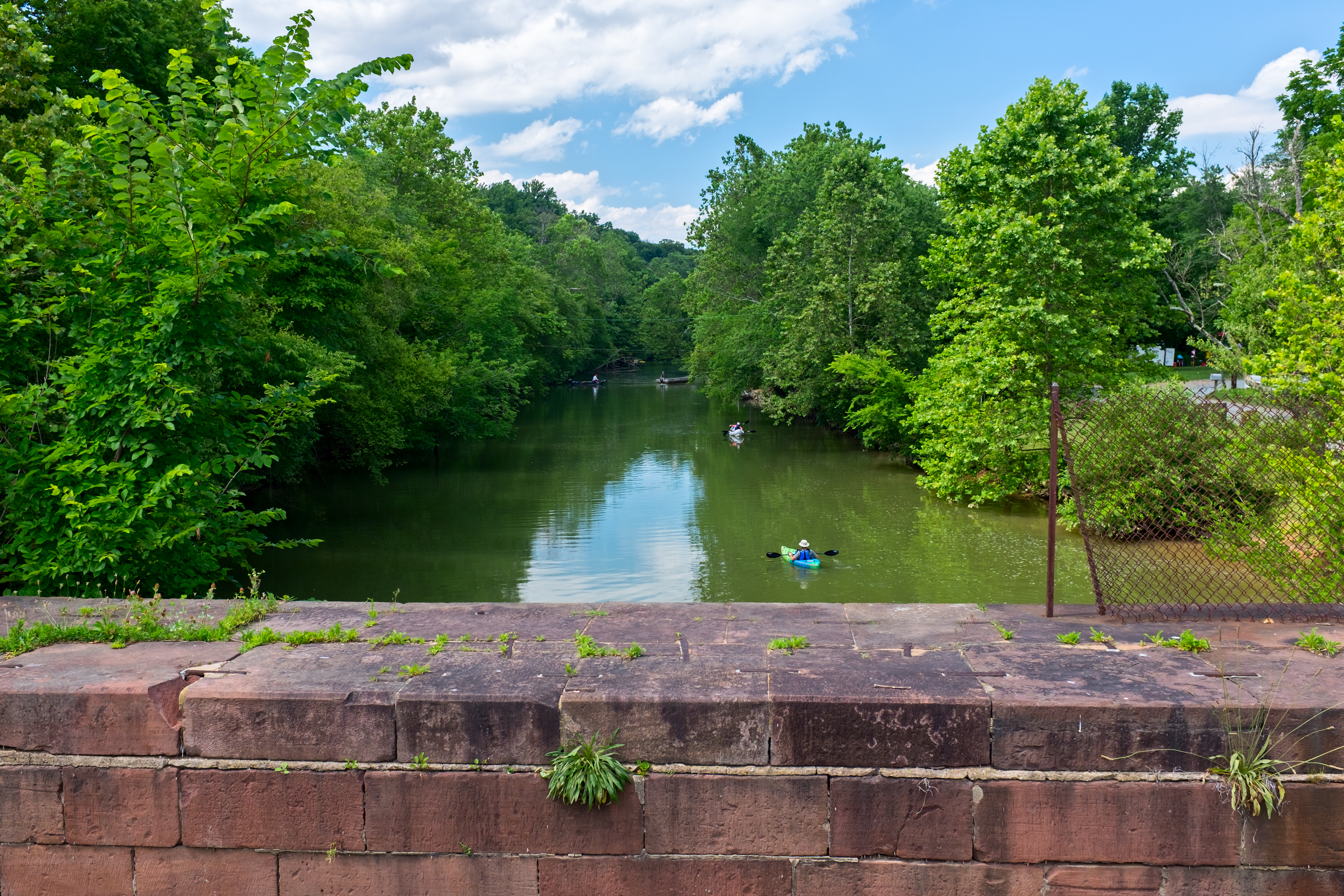
Seneca Creek State Park is an irregular-shaped park of 6300 acre that follows Seneca Creek for 14 mile from beyond Clopper Lake (northern part of Darnestown CDP) to the Potomac River (southern part of Darnestown CDP). The park has 50 mile of trails for hiking, horseback riding and biking.{{cite web |access-date=2020-05-19}}{{cite web |access-date=2020-05-13}} Riley's Lock and Violette's Lock are two canal locks in the Chesapeake and Ohio Canal National Historical Park that are within the Darnestown CDP, and the Pennyfield Lock is nearby.{{cite web |access-date=2020-04-14}}{{cite web |access-date=2020-09-02}}{{cite web |access-date=2020-09-02}} These locks are used by kayakers, bikers, and hikers, and are also good places to observe wildlife.{{cite web |access-date=2020-09-02}} The 40–acre (16 ha) Dierssen Waterfowl Sanctuary is located at towpath marker 20.0 between Violette's Lock and the Pennyfield Lock.{{cite web |access-date=2020-08-07}}
The Darnestown CDP has six county parks and an undeveloped conservation area. The Berryville Road Neighborhood Conservation Area is 3.83 acres of undeveloped woodland located between Seneca Road and Seneca Creek.{{cite web |access-date=2021-07-08}} Darnestown Heritage Park and Darnestown Local Park are located in the Darnestown village. The local park is 10 acre in size, and has a playground, softball field, small multi-use field, and two tennis courts.{{cite web |access-date=2020-05-19}} More county parks are located close to the Potomac River, including the Seneca Landing Special Park that has a boat landing near Riley's Lock.{{cite web |access-date=2020-05-19}} The 630-acre (250 ha) Blockhouse Point Conservation Park, which has views of the Potomac River and ruins from the American Civil War, is also located along the Potomac River and C&O Canal.{{cite web |access-date=2020-04-16}} The Callithea Farm Special Park is a 91-acre (37ha) horse farm.{{cite web |access-date=2020-05-19}} A sixth park, Muddy Branch Stream Valley Park, is 876 acres that follow the Muddy Branch and contains the Muddy Branch Greenway Trail.{{cite web |access-date=2020-05-31}}
The Montgomery County Park System has over 200 mi of hiking trails.{{cite web |access-date=2020-03-17}} Among those trails is the Muddy Branch Greenway Trail, which passes North Potomac's Potomac Horse Center on a 9-mile (14 km) route between Darnestown Road and Blockhouse Point Conservation Park near the Potomac River.{{cite web |access-date=2020-03-17}} The Potomac Horse Center, located adjacent to the Darnestown CDP, is a special county park that offers training for horses and riders.{{cite web |access-date=2020-09-05}} Construction of the Powerline Trail (a.k.a. Pepco Trail) began in 2018, and this trail will connect Muddy Branch Stream Valley Park with the South Germantown Recreation Park, which is the home of the Maryland SoccerPlex.{{cite news |access-date=2020-03-20 |access-date=2020-03-20}} The Maryland SoccerPlex is located less than 5 mi from the Darnestown village and has indoor and outdoor facilities for soccer and other activities.{{cite web |access-date=2020-04-16}}
Notes
Footnotes
Citations
References
- {{Cite book
- {{Cite book | access-date = 2020-08-27
- {{Cite book
- {{Cite book
- {{Cite book | access-date = 2020-03-26
- {{Cite book
- {{Cite book
- {{Cite book | access-date = 2020-07-19
- {{Cite book
- {{Cite book | access-date = 2020-07-25
- {{Cite book | access-date = 2020-07-19 |access-date=2020-07-15}}--
- {{Cite book | access-date = 2020-07-15
- {{Cite book | access-date = 2020-03-15
- {{Cite book | access-date = 2020-03-15
- {{Cite book | archive-url = https://web.archive.org/web/20210307224754/https://www.census.gov/prod/cen2010/cph-2-22.pdf | url-status = dead | archive-date = 2021-03-07 | access-date = 2020-12-07
- {{Cite book | access-date = 2020-03-15
- {{Cite book | access-date = 2020-08-19
- {{Cite book | access-date = 2020-08-09
- {{Cite book
References
- {{GNIS. 2389395
- "QuickFacts: Darnestown CDP, Maryland". United States Census Bureau.
- {{harvnb. Boyd. 1879
- {{harvnb. Montgomery County Historical Society. 1999
- {{harvnb. Curtis. 2020
- Fielding Lucas Jr.. (1841). "Map of the State of Maryland (from Lib. of Congress)". Fielding Lucas, Jr..
- {{harvnb. United States Post Office Department. 1803
- {{harvnb. Kenny. 1984
- {{harvnb. United States Post Office Department. 1828
- {{harvnb. Scharf. 1882
- {{harvnb. Tremayne. 1850
- {{harvnb. Kelly. Maryland-National Capital Park and Planning Commission. 2011
- {{harvnb. Montgomery County Historical Society. 1999
- {{harvnb. Kelly. Maryland-National Capital Park and Planning Commission. 2011
- {{harvnb. Kelly. Maryland-National Capital Park and Planning Commission. 2011
- {{harvnb. Hopkins. 1879
- {{harvnb. Boyd. 1879
- {{harvnb. Buglass. 2015
- {{harvnb. Kelly. Maryland-National Capital Park and Planning Commission. 2011
- {{harvnb. Scharf. 1882
- {{harvnb. Scharf. 1882
- {{harvnb. Curtis. 2020
- {{harvnb. Hopkins. 1879
- {{harvnb. United States Census Bureau. 1973
- G. M. Hopkins. (1879). "Atlas of Fifteen Miles Around Washington...Image 26 Darnestown Dist. No. 6 (from Lib. of Congress)". F. Bourquin's Steam Lithographic Press.
- {{harvnb. United States Census Bureau. 2003
- "Quick Facts - Darnestown CDP, Maryland". U.S. Census Bureau, U.S. Department of Commerce.
- "Darnestown, CDP, Maryland - Place Selection Map". U.S. Census Bureau, U.S. Department of Commerce.
- {{cite GNIS
- (2020). "Regional Service Centers - Service Regions and ZIP Codes". Montgomery County Government.
- {{harvnb. United States Census Bureau. 1895
- {{harvnb. United States Census Bureau. 1925
- {{harvnb. United States Census Bureau. 1953
- {{harvnb. Boyd. 1879
- {{harvnb. Scharf. 1882
- {{harvnb. United States Census Bureau. 2003
- {{harvnb. United States Census Bureau. 2003
- {{harvnb. United States Census Bureau. 2012
- {{harvnb. United States Census Bureau. 2012
- {{harvnb. United States Census Bureau. 2012
- {{harvnb. United States Census Bureau. 2012
- {{harvnb. United States Department of Transportation. Maryland Department of Transportation. 2002
- Montgomery County Public Schools (Maryland). (2020). "Northwest HS Service Area 2021-2022". Montgomery County Public Schools Division of Capital Planning.
- {{harvnb. Zdravkovska. 2011
This article was imported from Wikipedia and is available under the Creative Commons Attribution-ShareAlike 4.0 License. Content has been adapted to SurfDoc format. Original contributors can be found on the article history page.
Ask Mako anything about Darnestown, Maryland — get instant answers, deeper analysis, and related topics.
Research with MakoFree with your Surf account
Create a free account to save articles, ask Mako questions, and organize your research.
Sign up freeThis content may have been generated or modified by AI. CloudSurf Software LLC is not responsible for the accuracy, completeness, or reliability of AI-generated content. Always verify important information from primary sources.
Report