From Surf Wiki (app.surf) — the open knowledge base
Dane County, Wisconsin
County in Wisconsin, United States
County in Wisconsin, United States
| Field | Value |
|---|---|
| county | Dane County |
| state | Wisconsin |
| seal | Dane County wi seal.png |
| founded year | 1836 |
| seat wl | Madison |
| largest city wl | Madison |
| area_total_sq_mi | 1238 |
| area_land_sq_mi | 1197 |
| area_water_sq_mi | 41 |
| area percentage | 3.3 |
| population_as_of | 2020 |
| population_total | 561504 |
| pop_est_as_of | 2024 |
| population_est | 588347 |
| density_sq_mi | auto |
| time zone | Central |
| web | danecounty.gov |
| ex image | Wisconsin State Capitol Building 6.jpg |
| ex image size | 250px |
| ex image cap | Wisconsin State Capitol building in Dane County |
| named for | Nathan Dane |
| district | 2nd |
| leader_title | Executive |
| leader_name | Melissa Agard |
Dane County is a county in the U.S. state of Wisconsin. As of the 2020 census, the population was 561,504, making it the second-most populous county in Wisconsin after Milwaukee County. Dane County is the fastest growing county in Wisconsin. It contains nearly 10% of the population of Wisconsin, and it only contained 5% of Wisconsin's population in 1950.
The county seat is Madison, which is also the state capital. Dane County is the central county of the Madison metropolitan area, as well as the Madison–Janesville–Beloit combined statistical area.
History
Dane County was formed in 1836 as a territorial county and organized in 1839. It was named after Nathan Dane, a Massachusetts delegate to the Congress of the Confederation who helped carve Wisconsin out of the Northwest Territory. Dane County was settled in the 1840s by settlers from New England.
Geography
According to the U.S. Census Bureau, the county has an area of 1238 sqmi, of which 1197 sqmi is land and 41 sqmi (3.3%) is water.
Major highways
- [[Image:I-39.svg|20px]] Interstate 39
- [[Image:I-90.svg|20px]] Interstate 90
- [[Image:I-94.svg|20px]] Interstate 94
- [[Image:US 12.svg|20px]] U.S. Route 12
- [[Image:US 14.svg|20px]] U.S. Route 14
- [[Image:US 18.svg|20px]] U.S. Route 18
- [[Image:US 51.svg|20px]] U.S. Route 51
- [[Image:US 151.svg|20px]] U.S. Route 151
- [[Image:WIS 19.svg|20px]] Highway 19 (Wisconsin)
- [[Image:WIS 30.svg|20px]] Highway 30 (Wisconsin)
- [[Image:WIS 69.svg|20px]] Highway 69 (Wisconsin)
- [[Image:WIS 73.svg|20px]] Highway 73 (Wisconsin)
- [[Image:WIS 78.svg|20px]] Highway 78 (Wisconsin)
- [[Image:WIS 89.svg|20px]] Highway 89 (Wisconsin)
- [[Image:WIS 92.svg|20px]] Highway 92 (Wisconsin)
- [[Image:WIS 104.svg|20px]] Highway 104 (Wisconsin)
- [[Image:WIS 106.svg|20px]] Highway 106 (Wisconsin)
- [[Image:WIS 113.svg|20px]] Highway 113 (Wisconsin)
- [[Image:WIS 134.svg|20px]] Highway 134 (Wisconsin)
- [[Image:WIS 138.svg|20px]] Highway 138 (Wisconsin)
- [[Image:WIS 188.svg|20px]] Highway 188 (Wisconsin)
Railroads
Freight
- Canadian Pacific
- Wisconsin and Southern Railroad
Buses
Public Transit
- Metro Transit
Intercity
- Van Galder/Coach USA
- Wisconsin Coach Lines/Coach USA
- Greyhound Lines
- Flixbus
- Badger Bus
- Jefferson Lines
- Lamers Connect
- Megabus
Airports
Commercial
- Dane County Regional Airport (MSN)
General Aviation
- Blackhawk Airfield (87Y)
- Middleton Municipal Airport (C29)
- Verona Airport (W19)
- Waunakee Airport (6P3)
Adjacent counties
- Columbia County (north)
- Dodge County (northeast)
- Green County (south)
- Iowa County (west)
- Jefferson County (east)
- Rock County (southeast)
- Sauk County (northwest)
Demographics
|align-fn=center 1790–1960 1900–1990 1990–2000 2010–2020 2020 census
In 2017, there were 5,891 births, giving a general fertility rate of 51.7 births per 1000 women aged 15–44, the eighth lowest rate out of all 72 Wisconsin counties. Of these, 73 of the births occurred at home, the fifth highest number of home births for Wisconsin counties. 428 of the births were to mothers who held doctorate or professional degrees, more than any other Wisconsin county. These accounted for 7.3% of total births for the county, a higher percent than any other Wisconsin county and more than Ozaukee County which had 5.8% of births to mothers who held doctorate or professional degrees and ranked second.
2020 census
As of the 2020 census, the county had a population of 561,504. The population density was 469.3 PD/sqmi. There were 248,795 housing units at an average density of 207.9 /mi2.
There were 238,417 households in the county, of which 25.7% had children under the age of 18 living in them. Of all households, 43.2% were married-couple households, 21.7% were households with a male householder and no spouse or partner present, and 26.7% were households with a female householder and no spouse or partner present. About 32.5% of all households were made up of individuals and 9.7% had someone living alone who was 65 years of age or older.
The median age was 35.7 years. 20.1% of residents were under the age of 18 and 14.7% of residents were 65 years of age or older. For every 100 females there were 98.5 males, and for every 100 females age 18 and over there were 96.9 males age 18 and over.
The racial makeup of the county was 77.6% White, 5.4% Black or African American, 0.4% American Indian and Alaska Native, 6.4% Asian,
Eighty-six point four percent of residents lived in urban areas, while 13.6% lived in rural areas. Among the 248,795 housing units, 4.2% were vacant. Among occupied housing units, 56.3% were owner-occupied and 43.7% were renter-occupied. The homeowner vacancy rate was 0.8% and the rental vacancy rate was 3.9%.
2010 census
At the 2010 census there were 488,073 people, 203,750 households, and 116,752 families living in the county. The population density was 394 /mi2. There were 216,022 housing units at an average density of 174 /mi2. The racial makeup of the county was 84.7% White, 5.2% Black or African American, 0.4% Native American, 4.7% Asian, 0.003% Pacific Islander, 2.5% from other races, and 2.5% from two or more races. 5.9% of the population were Hispanic or Latino of any race. Of the 203,750 households 27.0% had children under the age of 18 living with them, 45.1% were married couples living together, 8.6% had a female householder with no husband present, and 42.7% were non-families. 30.5% of households were one person and 7.7% were one person aged 65 or older. The average household size was 2.33 and the average family size was 2.95.
The age distribution was 21.7% under the age of 18, 12.8% from 18 to 24, 29.5% from 25 to 44, 25.7% from 45 to 64, and 10.3% 65 or older. The median age was 34.4 years. For every 100 females, there were 97.80 males. For every 100 females age 18 and over, there were 96.00 males.
2000 census
At the 2000 census there were 426,526 people, 173,484 households, and 100,794 families living in the county. The population density was 355 /mi2. There were 180,398 housing units at an average density of 150 /mi2. The racial makeup of the county was 88.96% White, 4.00% Black or African American, 0.33% Native American, 3.45% Asian, 0.03% Pacific Islander, 1.43% from other races, and 1.79% from two or more races. 3.37% of the population were Hispanic or Latino of any race. 34.4% were of German, 11.5% Norwegian, 8.9% Irish and 6.0% English ancestry. Of the 173,484 households 29.00% had children under the age of 18 living with them, 47.10% were married couples living together, 7.90% had a female householder with no husband present, and 41.90% were non-families. 29.40% of households were one person and 7.00% were one person aged 65 or older. The average household size was 2.37 and the average family size was 2.97.
The age distribution was 22.60% under the age of 18, 14.30% from 18 to 24, 32.50% from 25 to 44, 21.30% from 45 to 64, and 9.30% 65 or older. The median age was 33 years. For every 100 females, there were 97.90 males. For every 100 females age 18 and over, there were 96.00 males.
Religion
In 2010, the largest religious groups in Dane County by number of adherents were Catholic at 106,036 adherents, ELCA Lutheran at 48,620 adherents, United Methodist at 9,753 adherents, non-denominational Christian at 7,448 adherents, Evangelical Free at 6,075 adherents, United Church of Christ at 5,035 adherents, Wisconsin Synod Lutheran at 4,214 adherents, Missouri Synod Lutheran at 3,921 adherents, American Baptist at 3,755 adherents, and PC-USA Presbyterian at 3,664 adherents.
Government
Dane County is governed by a county executive and a county board of supervisors. The county executive is elected in a countywide vote. The county executive is Melissa Agard. The board of supervisors consists of 37 members, each elected from single member districts. As the policy-making body of the county government, the board of supervisors enacts county ordinances, levies taxes, and appropriates money for services.
Economy
Dane County's recent growth has been driven by new job opportunities in healthcare and technology fields.
Politics
Like most other counties anchored by an urban population center and a large public university, Dane County is solidly Democratic, with a long history in the progressive movement. It has backed the Democratic presidential nominee in every election since 1932 with the exception of the two nationwide landslide victories of Dwight D. Eisenhower in 1952 and 1956, and even then, Eisenhower's margin of victory was under 3% both times. Since then, Republicans have only crossed the 35% mark six times. Within Wisconsin, only the predominantly Native American county of Menominee is more reliably Democratic.
At state level, the county is no less Democratic. The last Republicans the county supported at state level were Governor Tommy Thompson and Treasurer Jack Voight in 1994. The last Republican Senator to carry the county was Alexander Wiley in 1956 by less than one percent, 10 years earlier the county was the only one in the state to not vote for notorious Senator Joseph McCarthy. In the three-party era of 1930s-1940s, the county backed Progressive Party candidates, such as the La Follette brothers, Orland Steen Loomis and Herman Ekern.
County executives
- George Reinke, 1973–1981
- Jonathan B. Barry, 1981–1988
- Richard J. Phelps, 1988–1997
- Kathleen Falk, April 21, 1997 – April 18, 2011
- Joe Parisi, April 18, 2011 – May 3, 2024
- Patrick Miles (acting), May 3, 2024 – May 17, 2024
- Jamie Kuhn (interim), May 17, 2024 – November 13, 2024
- Melissa Agard, November 13, 2024 – present
Recreation
County parks
- Babcock County Park
- Badger Prairie County Park
- Blooming Grove Drumlins
- Blue Mounds Natural Resource Area
- Brigham County Park
- CamRock County Park
- Cherokee Marsh
- Donald County Park
- Festge County Park
- Fish Camp County Park
- Fish Lake County Park
- Goodland County Park
- Halfway Prairie School
- Indian Lake County Park
- Jenni & Kyle Preserve
- La Follette County Park
- Lake Farm County Park
- Lake View Hill Park
- Lussier County Park
- McCarthy County Park
- Mendota County Park
- Phil's Woods County Park
- Prairie Moraine County Park
- Riley-Deppe County Park
- Salmo Pond County Park
- Scheidegger Forest
- Schumacher Farm
- Stewart Lake County Park
- Token Creek County Park
- Viking County Park
- Walking Iron County Park
- Yahara Heights County Park
Communities
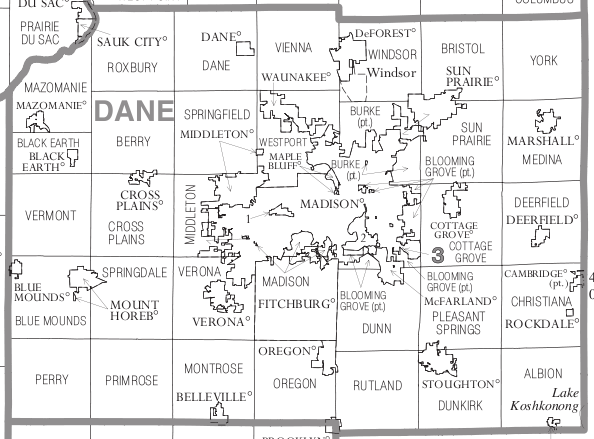
Main article: Administrative divisions of Wisconsin
Cities
: Cities are incorporated, generally have a mayor (or a administrator/manager), an elected council, and generally provide more services than smaller administrative divisions.
- Edgerton (mostly in Rock County)
- Fitchburg
- Madison (county seat)
- Middleton
- Monona
- Stoughton
- Sun Prairie (city)
- Verona
Villages
: Villages are incorporated, are governed by a Village President and Board of Trustees, and provide residential services.
- Belleville (partly in Green County)
- Black Earth
- Blue Mounds
- Brooklyn (partly in Green County)
- Cambridge (partly in Jefferson County)
- Cottage Grove
- Cross Plains
- Dane
- Deerfield
- DeForest
- Maple Bluff
- Marshall
- Mazomanie
- McFarland
- Mount Horeb
- Oregon
- Rockdale
- Shorewood Hills
- Waunakee
- Windsor
Towns
: Towns may have the same name as a city or village associated with it, but it is a separate municipality. Towns are not incorporated, are governed by a town board, and only provide limited services to residents.
- Albion
- Berry
- Black Earth (town)
- Blooming Grove
- Blue Mounds (town)
- Bristol
- Burke
- Christiana
- Cottage Grove (town)
- Cross Plains
- Dane
- Deerfield (town)
- Dunkirk
- Dunn
- Mazomanie (town)
- Medina
- Middleton (town)
- Montrose
- Oregon (town)
- Perry
- Pleasant Springs
- Primrose
- Roxbury
- Rutland
- Springdale
- Springfield
- Sun Prairie (town)
- Vermont
- Verona
- Vienna
- Westport
- York
Unincorporated communities
: Unincorporated communities are smaller communities that are governed by the town they are located in and often exist as nomenclature in vital records.
- Albion
- Aldens Corners
- Ashton
- Basco
- Burke
- Daleyville
- Deansville
- Door Creek
- Dunkirk
- East Bristol
- Elvers
- Five Points
- Forward
- Hanerville
- Highwood
- Hillside
- Hoffman Corners
- Indian Heights
- Kegonsa
- Kingsley Corners
- Klevenville
- London (partial)
- Lutheran Hill
- Martinsville
- Marxville
- Montrose
- Mt. Vernon
- Nora
- Norway Grove
- Old Deerfield
- Paoli
- Pierceville
- Pine Bluff
- Primrose
- Riley
- Roxbury
- Rutland
- Seminary Springs
- Schey Acres
- Springfield Corners
- Stone
- Token Creek
- Utica
- Vermont
- Vilas
- West Middleton
- York Center
Neighborhoods
: Neighborhoods exist mostly for nomenclature purposes; some may have administrative associations with powers that are defined in the property deed covenants of the neighborhood. This is a partial list that primarily consists of former unincorporated communities that are now within the boundaries of an incorporated city or village.
- Hope (Madison)
- Lake Windsor (Windsor)
- Fitchburg Center (Fitchburg)
- Middleton Junction (Madison)
- Morrisonville (Windsor)
- Oak Hall (Fitchburg)
Native American community
- Ho-Chunk Indian Reservation
Education
School districts (all K-12) include:
- Barneveld School District
- Belleville School District
- Cambridge School District
- Columbus School District
- DeForest Area School District
- Deerfield Community School District
- Edgerton School District
- Evansville Community School District
- Lodi School District
- Madison Metropolitan School District
- Marshall School District
- McFarland School District
- Middleton-Cross Plains School District
- Monona Grove School District
- Mount Horeb Area School District
- New Glarus School District
- Oregon School District
- Pecatonica Area School District
- Poynette School District
- River Valley School District
- Sauk Prairie School District
- Stoughton Area School District
- Sun Prairie Area School District
- Verona Area School District
- Waterloo School District
- Waunakee Community School District
- Wisconsin Heights School District
References
References
- "Dane County, Wisconsin Demographics and Housing 2020 Decennial Census".
- "What are the fastest growing counties in Wisconsin? Here's what census data shows". Milwaukee Journal-Sentinel.
- "Find a County". National Association of Counties.
- (2007). "Wisconsin: Individual County Chronologies". [[Newberry Library]].
- "[https://www.wisconsinhistory.org/Records/Newspaper/BA9479 Early Wisconsin]". ''The Milwaukee Journal'', September 26, 1896.
- Gannett, Henry. (1905). "The Origin of Certain Place Names in the United States". [[United States Government Publishing Office.
- (1898). "The Red Book of the Sun Prairie Methodist Episcopal Church". C. M. Starkweather.
- (August 22, 2012). "2010 Census Gazetteer Files". United States Census Bureau.
- "Annual Estimates of the Resident Population for Counties: April 1, 2020 to July 1, 2023". United States Census Bureau.
- "U.S. Decennial Census". Census Bureau.
- "Historical Census Browser". University of Virginia Library.
- (March 27, 1995). "Population of Counties by Decennial Census: 1900 to 1990". Census Bureau.
- (April 2, 2001). "Census 2000 PHC-T-4. Ranking Tables for Counties: 1990 and 2000". Census Bureau.
- (July 1, 2018). "Quick Facts: Dane County, Wisconsin". [[United States Census Bureau.
- "U.S. Census Bureau QuickFacts: Dane County, Wisconsin; United States".
- "Annual Wisconsin Birth and Infant Mortality Report, 2017 P-01161-19 (June 2019): Detailed Tables".
- (2021). "2020 Decennial Census Redistricting Data (Public Law 94-171)".
- (2021). "2020 Decennial Census Demographic Profile (DP1)".
- (2023). "2020 Decennial Census Demographic and Housing Characteristics (DHC)".
- "U.S. Census website". Census Bureau.
- [http://www.thearda.com/rcms2010/rcms2010A.asp?U=55025&T=county&Y=2010&S=Name thearda.com County Membership Report: Dane County (Wisconsin)]
- Leip, David. "Dave Leip's Atlas of U.S. Presidential Elections".
- "1994 Gubernatorial General Election Results - Wisconsin".
- "1994 State Treasurer General Election Results - Wisconsin".
- "1956 Senatorial General Election Results - Wisconsin".
- "1946 Senatorial General Election Results - Wisconsin".
- "Our Campaigns - WI US Senate Race - Nov 05, 1940".
- "Our Campaigns - WI Governor Race - Nov 03, 1942".
- Geography Division. (January 14, 2021). "2020 Census - School District Reference Map: Dane County, WI". [[U.S. Census Bureau]].
- "School Districts, WI". [[Wisconsin Department of Public Instruction]].
This article was imported from Wikipedia and is available under the Creative Commons Attribution-ShareAlike 4.0 License. Content has been adapted to SurfDoc format. Original contributors can be found on the article history page.
Ask Mako anything about Dane County, Wisconsin — get instant answers, deeper analysis, and related topics.
Research with MakoFree with your Surf account
Create a free account to save articles, ask Mako questions, and organize your research.
Sign up freeThis content may have been generated or modified by AI. CloudSurf Software LLC is not responsible for the accuracy, completeness, or reliability of AI-generated content. Always verify important information from primary sources.
Report