From Surf Wiki (app.surf) — the open knowledge base
Dampier Peninsula
Peninsula in Western Australia
Peninsula in Western Australia
| Field | Value |
|---|---|
| type | other |
| name | Dampier Peninsula |
| image | cape-leveque-west.jpg |
| coordinates | |
| state | wa |
The Dampier Peninsula is a peninsula located north of Broome and Roebuck Bay in the Kimberley region of Western Australia, named after the mariner and explorer William Dampier who visited it. It is surrounded by the Indian Ocean to the west and north, and King Sound to the east. The northernmost part of the peninsula is Cape Leveque. It is sparsely inhabited, mostly by Indigenous Australian peoples, some of whom have been granted native title rights to some of their traditional lands. There are many coastal inlets, bays, and other features, including Beagle Bay on its western side.
Aboriginal heritage
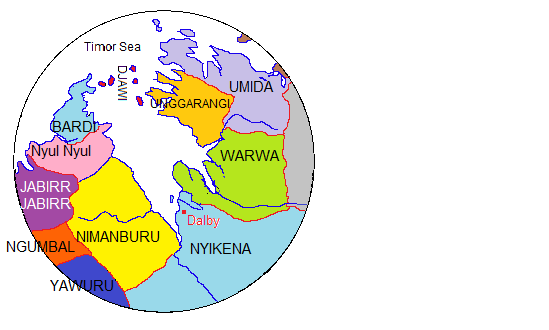
The traditional owners of the areas around the peninsula are the Bardi, Nyunyul, and Jabirr Jabirr (Djaberadjabera) peoples.
Ecology
Many small trees, shrubs, and animals live on and in the sea surrounding the peninsula, the most characteristic vegetation being pindan woodland within the interior sandplains.
Mangroves are an important part within the peninsula, with 12 of Western Australia's 17 species present. Flying Fox colonies commonly roost in the trees during the day before foraging at dusk.https://library.dbca.wa.gov.au/static/FullTextFiles/016991.pdf
page 31 and 39.
Transport
The peninsula is traversed from south to north through Cape Leveque Road.
Numerous tour operators run bus services on the peninsula.
Air strips are situated at Cape Leveque, Bardi, Djarindjin (Lombadina), Beagle Bay, and some of the smaller communities and pearl farms.
Tourism
There are several tourist accommodation facilities such as Cygnet Bay Pearl Farm (Cape Leveque), Kooljamon (Cape Leveque) and Middle Lagoon (Middle Lagoon).
References
References
- This map is indicative only.
- (2012). "Ausanthrop - Australian Aboriginal tribal database".
- Staff, Perth Is OK. (2026-01-19). "Cygnet Bay Pearl Farm: An award-winning combo of comfort, culture and adventure in the Kimberley".
This article was imported from Wikipedia and is available under the Creative Commons Attribution-ShareAlike 4.0 License. Content has been adapted to SurfDoc format. Original contributors can be found on the article history page.
Ask Mako anything about Dampier Peninsula — get instant answers, deeper analysis, and related topics.
Research with MakoFree with your Surf account
Create a free account to save articles, ask Mako questions, and organize your research.
Sign up freeThis content may have been generated or modified by AI. CloudSurf Software LLC is not responsible for the accuracy, completeness, or reliability of AI-generated content. Always verify important information from primary sources.
Report