From Surf Wiki (app.surf) — the open knowledge base
Dakota County, Minnesota
County in Minnesota, United States

County in Minnesota, United States
| Field | Value |
|---|---|
| county | Dakota County |
| state | Minnesota |
| founded date | October 27 |
| founded year | 1849 |
| seat wl | Hastings |
| largest city wl | Lakeville |
| area_total_sq_mi | 587 |
| area_land_sq_mi | 562 |
| area_water_sq_mi | 25 |
| area percentage | 4.2% |
| population_as_of | 2020 |
| population_total | 439882 |
| pop_est_as_of | 2024 |
| population_est | 453156 |
| density_sq_mi | auto |
| time zone | Central |
| web | https://www.co.dakota.mn.us/Pages/default.aspx |
| named for | the Dakota people |
| ex image | DakotaCH1.jpg |
| ex image cap | Dakota County Courthouse |
| district | 2nd |
Dakota County is the third-most populous county in the U.S. state of Minnesota, located in the east central portion of the state. As of the 2020 census, the population was 439,882. The population of Dakota County was estimated to be 453,156 in 2024. The county seat is Hastings. Dakota County is named for the Dakota Sioux tribal bands who inhabited the area. The name is recorded as "Dahkotah" in the United States Census records until 1851. Dakota County is included in the Minneapolis–St. Paul–Bloomington, MN–WI Metropolitan Statistical Area, the sixteenth largest metropolitan area in the United States with about 3.71 million residents. The largest city in Dakota County is the city of Lakeville, the ninth-largest city in Minnesota and fifth-largest Twin Cities suburb. The county is bordered by the Minnesota and Mississippi Rivers on the north, and the state of Wisconsin on the east.
History
The county was the site of historical events at Mendota that defined the state's future, including providing materials for the construction of Fort Snelling across the river and the signing of the Treaty of Mendota which ceded land from the native Dakota nation for the Minnesota Territory. The county's history was initially tied to the confluence of the Mississippi and Minnesota Rivers, both strategically important for United States expansion and as the convergence of the Dakota and Ojibwe nations who regarded the site as sacred. Influence shifted westward during the post-World War II settlement boom when Interstate 35 connected the western half of the county to Minneapolis and Saint Paul and bedroom communities grew. Most work outside the county but like many metro counties, Dakota County continues to absorb industry and jobs from the core cities.
In the 1600s, Mdewakanton Dakota fled their ancestral home of Mille Lacs Lake in northern Minnesota in response to westward expansion of the Ojibwe nation. According to Dakota tradition, their ancestors pushed out the Iowa who were found settled at the mouth of the Minnesota River. In 1680, the Mdewakanton Dakota were contacted by French explorer Daniel Greysolon, Sieur du Lhut, and the Mendota (mdo-TE) band of the Mdewakanton south of the Minnesota River were contacted by Joseph Nicollet in the 18th century. While Taoyateduta (a.k.a. Little Crow) led the Mendota in northern Dakota County, upstream to the southwest, Chief Black Dog established his village of 600 people around 1750 at the isthmus between Black Dog Lake (which is named after him) and the Minnesota River, near the present site of the Black Dog Power Plant.

Following the published expeditions of explorers, in 1805, Zebulon Pike negotiated for military territory with the Mendota band which included land in Dakota County at the Mississippi River confluences with the Minnesota and St. Croix Rivers. In 1819, on what is now Picnic Island on the south bank of the Minnesota River, Colonel Henry Leavenworth built a stockade fort called "St. Peter's Cantonment" or "New Hope," where materials were assembled for the construction of Fort Snelling to be built on the bluff on the north bank. Permanent settlement on the island was impossible due to annual flooding. Alexis Bailey built some log buildings nearby to trade in furs in 1826. Henry Hastings Sibley later built the first stone house in Minnesota in 1836, overlooking Fort Snelling. Sibley was a partner in the American Fur Company, and considerable fur trade occurred at Mendota due to the accessibility of the confluence.
Ongoing United States expansion into the then "Northwest Territory" led to government purchase of land from the Dakota people (the Mdewakanton, Wahpekute, Wahpeton, and Sisseton bands) via the Treaty of St. Peters, the Treaty of Traverse des Sioux, and the Treaty of Mendota in 1851. After the Minnesota Territory was established in 1849, Dakotah County (later Dakota County) spanned from the Mississippi River to the Missouri River. By the time Minnesota achieved statehood in 1858, power and influence had shifted from Mendota, across the rivers to Saint Paul and Minneapolis.
Hastings and South St. Paul
By 1900, the hub of activity in the county was in Hastings, the county seat, and a focal point of transportation, communication, and commerce. St. Peter's, now Mendota, had lost out to Fort Snelling. Hastings is located on the Mississippi River at the confluence of the St. Croix River and on the Vermillion River, which provided ample water power. Lumber, milling, and railroads provided good incomes. During this time, the stockyards and meat-packing plants in South St. Paul, Minnesota became the world's largest stockyards. Ranchers in the west shipped their livestock to St. Louis, Memphis, and New Orleans. These plants were worked by immigrants from Romania, Serbia, and other Eastern European countries. The rest of the county remained agricultural during the boom of milling activity north of the Minnesota River due to lack of bridge connections. Rail access came in 1866 via the Chicago, St. Paul, Minneapolis, and Omaha Railroad which shipped grain to millers. The Minneapolis St. Paul Rochester and Dubuque Electric Traction Company line in 1905 (now the Dan Patch Corridor), was primary for passengers going to resorts in Burnsville and Lakeville.
Suburban growth
By the 1950s, population growth shifted to western Dakota County, which had been predominantly Irish and Scottish extending southward toward the Scandinavians of Southern Minnesota. As population pressures expanded south from Minneapolis and Bloomington, the completion of Interstate 35W and 35E brought about major construction in the post-World War II period, turning villages into cities within 20 years. Burnsville, Apple Valley, Eagan, and Lakeville brought over 200,000 people into the county by the end of the century. The Western and Northern Service Centers were constructed in the early 1990s each with an additional courthouse location. License centers were subsequently set up in Burnsville and Lakeville. Though pressure remained since the postwar boom to move the county seat to a larger community, the Dakota County Board maintained the seat in Hastings, while providing government services across the county.
Historic sites
The Registered Historic Places in the county include the settlement at Mendota, the homes of well-heeled residents of Hastings, the ethnic gathering places in South Saint Paul, and other sites related to life on the prairie.
Politics and government
Local government
Dakota County is governed by the Board of Commissioners. The members of the Board as of August 25, 2025, are:
- Mike Slavik, District 1
- Joe Atkins, District 2
- Laurie Halverson, District 3
- William Droste, District 4
- Liz Workman, District 5
- Mary Liz Holberg, District 6
- Mary Hamann-Roland, District 7 Dakota County has an elected Sheriff (Joe Leko) and an elected County Attorney (Kathryn M. Keena). There are appointed boards for the library system, community development agency, and several advisory boards. Dakota County is served by an elected board of the Soil and Water Conservation District.
Politics
Dakota County voters tend to vote Democratic. Since 1960, the county has selected the Democratic Party candidate in 71% of national elections (as of 2020).
Geography
The county terrain consists of low rolling hills, sloping to the river valleys. Its highest point is at Buck Hill in Burnsville, at 1,168 feet above sea level. The county has a total area of 587 sqmi, of which 562 sqmi is land and 25 sqmi (4.2%) is water.
Rivers
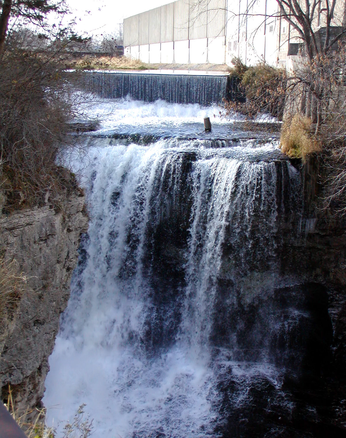
The northern and eastern boundaries of Dakota County are marked by the Minnesota and Mississippi Rivers. Management and jurisdiction of the rivers falls into multiple local, State and Federal agencies. Most of the Minnesota River bank is under the Minnesota Valley National Wildlife Refuge with fish, wildlife, and parkland managed collectively by the United States Fish and Wildlife Service and the Minnesota Department of Natural Resources. The Dakota County Soil and Water Conservation District assists the county's six watershed management organizations (WMO) which include the Black Dog WMO, Gun Club Lake WMO, Lower Minnesota River Watershed District, Lower Mississippi WMO, North Cannon River WMO, and the Vermillion River Watershed Joint Powers Organization.
- Mississippi River: Adjacent to Mendota Heights, Lilydale, South St. Paul, Inver Grove Heights, Rosemount, and Hastings.
- Minnesota River: Adjacent to Burnsville, Eagan, Mendota Heights, and Mendota.
- Vermillion River: From Farmington through Empire to Hastings.
- Cannon River: Adjacent to Randolph and through Randolph Township.
Lakes
Burnsville
- Alimagnet Lake
- Crystal Lake
- Earley Lake Eagan
- Blackhawk Lake
- Fish Lake
- Holland Lake
- Jensen Lake
- Thomas Lake Eureka Township
- Chub Lake Hastings
- Lake Rebecca
- Lake Isabelle
- Spring Lake
- Bullfrog Pond Lakeville
- Lake Marion
- Orchard Lake
- Kingsley Lake
- Valley Lake
- Lee Lake Lilydale
- Pickerel Lake Randolph Township
- Lake Byllesby Ravenna Township
- Mud Hen Lakes Rosemount
- Keegan Lake West Saint Paul
- Thompson Lake South St. Paul
- Siedls Lake Apple Valley
- Long Lake
- Farquar Lake
- Crystal Lake
- Keller Lake
- Alimagenet Lake
- Cobblestone Lake
Major highways
- [[File:I-35.svg|20px]] Interstate 35
- [[File:I-35E.svg|23px]] Interstate 35E
- [[File:I-35W.svg|23px]] Interstate 35W
- [[File:I-494.svg|23px]] Interstate 494
- [[File:US 52.svg|20px]] US Highway 52
- [[File:US 61.svg|20px]] US Highway 61
- [[File:MN-3.svg|20px]] Minnesota State Highway 3
- [[File:MN-13.svg|20px]] Minnesota State Highway 13
- [[File:MN-19.svg|20px]] Minnesota State Highway 19
- [[File:MN-20.svg|20px]] Minnesota State Highway 20
- [[File:MN-50.svg|20px]] Minnesota State Highway 50
- [[File:MN-55.svg|20px]] Minnesota State Highway 55
- [[File:MN-56.svg|20px]] Minnesota State Highway 56
- [[File:MN-62.svg|20px]] Minnesota State Highway 62
- [[File:MN-77.svg|20px]] Minnesota State Highway 77
- [[File:MN-149.svg|20px]] Minnesota State Highway 149
- [[File:MN-156.svg|20px]] Minnesota State Highway 156
- [[File:MN-316.svg|20px]] Minnesota State Highway 316
- [[File:County 42 (MN).svg|20px]] County Road 42
- [[File:County 23 (MN).svg|20px]] County Road 23
- Other County Roads
Adjacent counties
- Ramsey County - north
- Washington County - northeast
- Pierce County, Wisconsin - east
- Goodhue County - southeast
- Rice County - southwest
- Scott County - west
- Hennepin County - northwest
Protected areas
The following protected areas are within or partially within Dakota County:
- Chub Lake Wildlife Management Area
- Fort Snelling State Park (part)
- Hastings Sand Coulee Scientific and Natural Area
- Miesville Ravine Park Reserve (part)
- Minnesota Valley National Wildlife Refuge (part)
- Mississippi National River and Recreation Area (part)
- Murphy-Hanrehan Park Reserve (part)
- National Wildlife Refuge, Bloomington (part)
- Spring Lake Regional Park & Park Reserve
- Vermillion Highlands
- Whitetail Woods Regional Park
Parks
The following parks are located within Dakota County:
- Big Rivers Regional Trail
- Dakota County Bikeway System
- Dakota Woods Dog Park
- Lake Byllesby Regional Park
- Lebanon Hills Regional Park
- Thompson County Park
Economy
Since the county grew as a bedroom community of Minneapolis and Saint Paul, over half of the residents (54%) work outside the county.
Demographics
|align-fn=center 1790-1960 1900-1990 1990-2000 2010-2020
2020 census
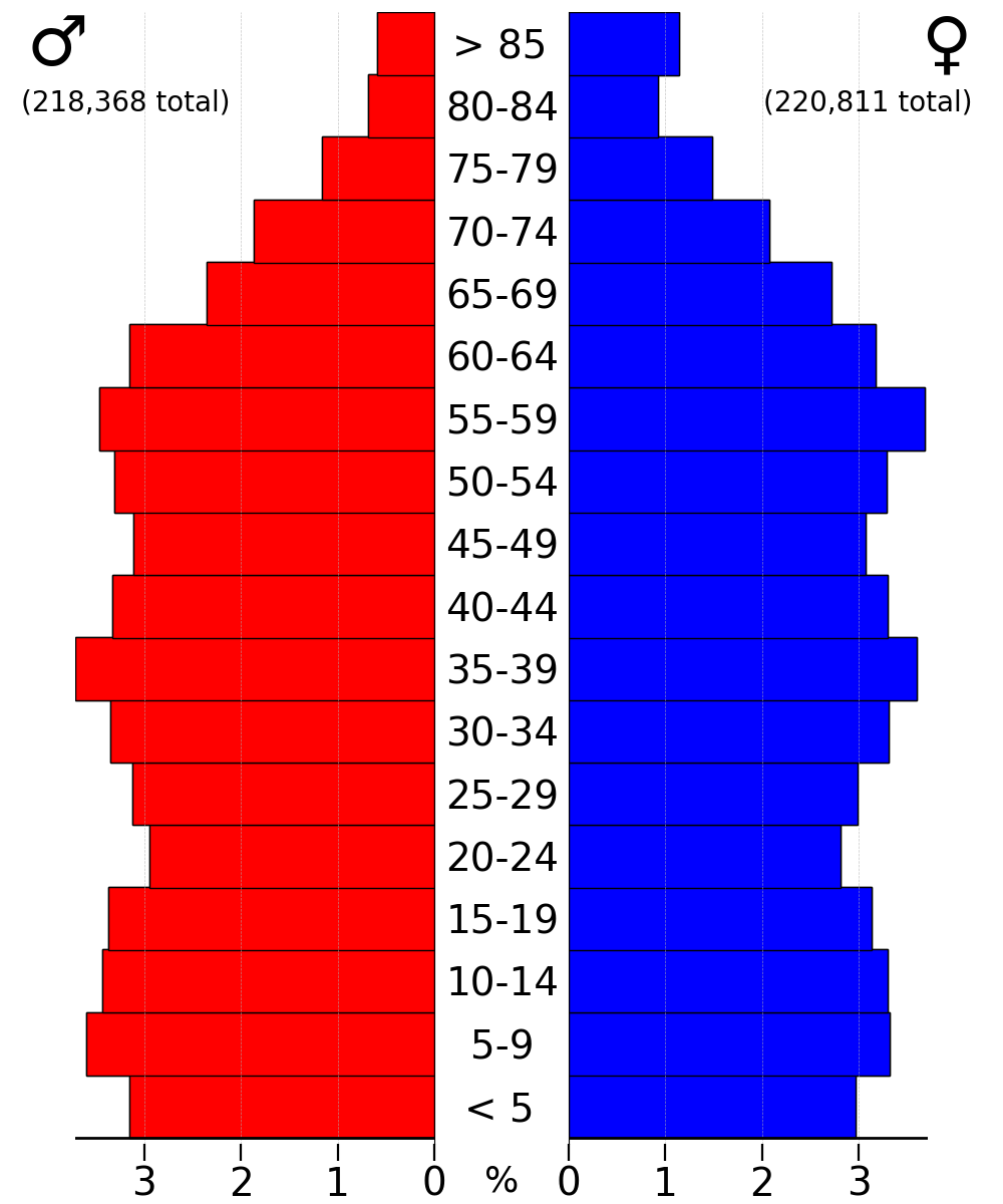
As of the 2020 census, the county had a population of 439,882. The median age was 38.6 years. 24.4% of residents were under the age of 18 and 14.8% of residents were 65 years of age or older. For every 100 females there were 95.9 males, and for every 100 females age 18 and over there were 93.2 males age 18 and over.
95.0% of residents lived in urban areas, while 5.0% lived in rural areas.
There were 168,008 households in the county, of which 33.0% had children under the age of 18 living in them. Of all households, 53.6% were married-couple households, 15.4% were households with a male householder and no spouse or partner present, and 24.2% were households with a female householder and no spouse or partner present. About 24.7% of all households were made up of individuals and 10.0% had someone living alone who was 65 years of age or older.
There were 173,469 housing units, of which 3.1% were vacant. Among occupied housing units, 74.0% were owner-occupied and 26.0% were renter-occupied. The homeowner vacancy rate was 0.6% and the rental vacancy rate was 4.8%.
Racial and ethnic composition
| Race / Ethnicity | title=P2 Hispanic or Latino, and Not Hispanic or Latino by Race - 2010: DEC Redistricting Data (PL 94-171) - Dakota County, Minnesota | url=https://data.census.gov/cedsci/table?q=p2&g=0500000US27037&tid=DECENNIALPL2010.P2 | website=United States Census Bureau}} | title=P2 Hispanic or Latino, and Not Hispanic or Latino by Race - 2020: DEC Redistricting Data (PL 94-171) - Dakota County, Minnesota | url=https://data.census.gov/cedsci/table?q=p2&g=0500000US27037&tid=DECENNIALPL2020.P2 | website=United States Census Bureau}} | % 2010 | % 2020 |
|---|---|---|---|---|---|---|---|---|
| White alone (NH) | 327,962 | 323,629 | 82.29% | 73.57% | ||||
| Black or African American alone (NH) | 18,235 | 32,191 | 4.58% | 7.32% | ||||
| Native American or Alaska Native alone (NH) | 1,339 | 1,490 | 0.34% | 0.34% | ||||
| Asian alone (NH) | 17,350 | 23,932 | 4.35% | 5.44% | ||||
| Pacific Islander alone (NH) | 199 | 184 | 0.05% | 0.04% | ||||
| Some Other Race alone (NH) | 647 | 2,144 | 0.16% | 0.49% | ||||
| Mixed Race/Multi-Racial (NH) | 8,854 | 20,007 | 2.22% | 4.55% | ||||
| Hispanic or Latino (any race) | 23,966 | 36,305 | 6.01% | 8.25% | ||||
| Total | 398,552 | 439,882 | 100.00% | 100.00% |
Note: the US Census treats Hispanic/Latino as an ethnic category. This table excludes Latinos from the racial categories and assigns them to a separate category. Hispanics/Latinos can be of any race.
2010 census
As of the census of 2010, Dakota County had a population of 398,552, of which 195,661 (49.1%) were male and 202,891 (50.9%) were female. In terms of age, 76.7% of the population were 16 years and over, 73.6% were 18 years and over, 70.5% were 21 years and over, 12.8% were 62 years and over, and 10.0% were 65 years and over. The median age was 36.8 years. The median age for males was 35.7; the median age for females was 37.9.
In terms of race and ethnicity, the county was 85.2% White (82.3% Non-Hispanic White), 4.7% Black or African American, 0.4% American Indian and Alaska Native, 4.4% Asian, 0.1% Native Hawaiian and Other Pacific Islander, 2.4% from some other race, and 2.9% from two or more races. Hispanics and Latinos of any race made up 6.0% of the population.
In terms of households, 69.5% were family households and 30.5% were non-family households. Approximately 55.2% were husband-wife family households; 26% had children under 18 years of age. Approximately 36.6% of households had children under 18 years of age living in them; 18.6% had people over the age of 65 living in them. The average household size was 2.60 and the average family size was 3.12. In terms of housing occupancy, 95.3% of households were occupied and 4.7% were vacant. Of the vacant housing units, 2.0% were for rent, 0.1% were rented but not occupied, 1.2% were for sale only, 0.2% were sold but not occupied, 0.5% were for seasonal, recreational, or occasional use, and 0.8% were all other vacants. The homeowner vacancy rate was 1.7% and the rental vacancy rate was 8.1%. Of all occupied housing units, 76.5% were owner-occupied and 23.5% were renter-occupied. The population in owner-occupied units was 314,833; the average household size was 2.71. The population in renter-occupied units was 80,866; the average household size was 2.26.
Education
Dakota County is home to the state's largest school districts and some of the highest paid Superintendents. Independent School District 196 (Rosemount–Apple Valley–Eagan) houses over 29,000 students and is the third-largest school district in the state. Other districts include Independent School District 191 (Burnsville–Eagan–Savage School District), Independent School District 194 (Lakeville–Elko–New Market), Independent School District 197 (West St. Paul–Mendota Heights–Eagan), Independent School District 200 (Hastings), Special School District 6 (South St. Paul).
School districts
School districts include:
- Burnsville Public School District
- Cannon Falls Public School District
- Farmington Public School District
- Hastings Public School District
- Inver Grove Heights Schools
- Lakeville Public School District
- Northfield Public School District
- Randolph Public School District
- Rosemount-Apple Valley-Eagan School District
- South St. Paul Public School District
- West St. Paul-Mendota Heights-Eagan School District
Colleges and universities
- Dakota County Technical College
- Inver Hills Community College
Libraries
Main article: Dakota County Library
- Burnhaven Library in Burnsville
- Farmington Library in Farmington
- Galaxie Library in Apple Valley
- Heritage Library in Lakeville
- Inver Glen Library in Inver Grove Heights
- Pleasant Hill Library in Hastings
- Robert Trail Library in Rosemount
- Kaposia Library in South St. Paul
- Wentworth Library in West St. Paul
- Wescott Library in Eagan
Communities
Dakota County is home to sites significant in the state's early history. At Mendota, the Treaty of Mendota was signed, opening Southern Minnesota to settlement, and prominent Saint Paul businessmen built their mansions there. Though linked with the state's capital for much of history via rail, Dakota County owes much of its current growth to the expansion of Minneapolis' population which accelerated during the post-World War II boom era of the 1960s. This demand for housing along with two major interstate highways linking Minneapolis (I-35W) and St. Paul (I-35E) to the county, concentrated major growth and demand along the northern end. Today, the cities of Burnsville, Eagan, Apple Valley, Lakeville, Rosemount, Hastings, Inver Grove Heights, Mendota Heights, West St. Paul, and South St. Paul are synonymous with the Twin Cities, as being part of "the Cities." Both Burnsville and Eagan are nearly developed and have become more like independent cities attracting major development than mere residential bedroom suburbs.

In contrast, the southern part of Dakota County reflects the rural past with small towns such as Farmington, Coates, Vermillion, Hampton, Randolph, and Miesville where street grids and housing dating from the early 20th century can be found. Much of the county is self-contained except for two examples. The City of Hastings, the county seat, lies on both banks of the Mississippi River and was linked historically and physically by rail to the growing influence of the state's capital, Saint Paul. On the south border, the City of Northfield, technically in Rice County, has expanded north into Dakota however the city itself is allowed into the municipal sewer boundary.
Though all of Dakota County is considered part of the metropolitan area and open to major development, the county government has steadily preserved farmland and continues to acquire new permanent natural lands in the southern townships. This has further defined the boundaries between urbanized and rural which is starkly visible in the outskirts of the developed cities. While the center of population still lies north with more cosmopolitan residents, culturally Dakota County is a rural community and the Dakota County Fair is still a largely agricultural event, held annually in Farmington.
Most of northern Dakota County is referred to as "South of the River" for its location being south of the Minnesota River.
Cities (2021 population estimate)
- Apple Valley 55,638
- Burnsville 63,943
- Coates 142
- Eagan 68,642
- Empire 2,444
- Farmington 23,534
- Hampton 736
- Hastings (partly in Washington County) 21,925
- Inver Grove Heights 35,541
- Lakeville 72,812
- Lilydale 800
- Mendota 183
- Mendota Heights 11,665
- Miesville 134
- New Trier 83
- Northfield (mostly in Rice County) 20,709
- Randolph 464
- Rosemount 26,642
- South St. Paul 20,536
- Sunfish Lake 523
- Vermillion 439
- West St. Paul 20,822
Unincorporated communities
- Castle Rock
- Etter
- Eureka Center
- Waterford
Ghost towns
- Lewiston
- Nininger
Townships
- Castle Rock Township
- Douglas Township
- Eureka Township
- Greenvale Township
- Hampton Township
- Marshan Township
- Nininger Township
- Randolph Township
- Ravenna Township
- Sciota Township
- Vermillion Township
- Waterford Township
Notable people
Main article: People from Dakota County, Minnesota
- Pierce Butler, United States Supreme Court justice
- Ignatius Donnelly, politician
- Steven Engler, politician
- David Knutson, Minnesota State Senator of District 37, 2003-2004
- William Gates LeDuc, pioneer, politician, brevet brigadier general
- Henry Hastings Sibley, first Governor of Minnesota
- Harold Stassen (R), Former Governor of Minnesota, Aide to Adm. Bull Halsey, Aide to President Dwight Eisenhower, Participant/Drafter of the United Nations Charter
References
References
- "Minnesota Place Names". Minnesota Historical Society.
- "State & County QuickFacts". United States Census Bureau.
- "Find a County". National Association of Counties.
- Charles Dosh. (2003–2007). "Dakota County Genealogy". MN Gen Web.
- (2005). "County Origin". Dakota County Historical Society.
- Kevin Monroe. (May 2006). "Public Assistance Caseload, Increase Analysis". Dakota County Employment and Economic Assistance.
- (1904). "Indian Affairs: Laws and Treaties". Oklahoma State University Library.
- (September 29, 1837). "Treaty with the Sioux".
- (July 23, 1851). "Treaty with the Sioux—Sisseton and Wahpeton Bands".
- (August 5, 1851). "Treaty With the Sioux—Mdewakanton and Wapahkoota Bands".
- Mark Morrison. (2008). "Dakota Life". City of Bloomington.
- (2008). "Handbook of American Indians, 1906".
- (2007). "Who We Are". Mendota Mdewakanton Dakota Community.
- Dakota County Historical Society. (2005). "Historic Sites: Burnsville".
- (1999). "The Treaty Story". Minnesota History Center.
- (2005). "Historic Sites:Mendota Heights". Dakota County Historical Society.
- Carley, Kenneth. (1976). "The Sioux Uprising of 1862". [[Minnesota Historical Society]].
- Lass, William. (1998). "Minnesota: A History". W. W. Norton & Co..
- Meyer, Roy Willard. (1993). "History of the Santee Sioux: United States Indian Policy on Trial". University of Nebraska Press.
- Dosh, Charles. "Welcome To Dakota County MN". MN Genweb.
- "South St. Paul Riverfront Trail".
- (2005). "County Origin". Dakota County Historical Society.
- "Historic Sites:South St. Paul". Dakota County Historical Society.
- ED Neill. (1881). "History of Dakota County 1881". Burnsville Heritage Committee.
- "The Dan Patch railway". St. Louis Park Historical Society.
- Kevin Gerahty. (March 2006). "Histories of the Dakota County Irish". Friends of the Highland Cemetery.
- Karen Miller. (1896). "The diary of Karen Miller". s.n..
- Dan Gearino. (August 11, 2000). "County breaks ground on $36.5 million Northern Service Center in West St. Paul". Thisweek Newspapers.
- "Board of Commissioners {{!}} Dakota County".
- Leip, David. "Atlas of US Presidential Elections".
- Nelson, Steven (2011). ''Savanna Soils of Minnesota''. Minnesota: Self. pp. 43 - 48. {{ISBN. 978-0-615-50320-2.
- [https://www.daftlogic.com/sandbox-google-maps-find-altitude.htm "Find an Altitude/Dakota County MN" Google Maps (accessed March 7, 2019)]
- {{Cite AmCyc
- (August 22, 2012). "2010 Census Gazetteer Files". United States Census Bureau.
- [http://www.dakotacountyswcd.org/wtshd_fs.htm Home - Dakota County Soil and Water Conservation District] {{webarchive. link. (July 19, 2008)
- [http://www.dnr.state.mn.us/waters/watermgmt_section/critical_area/index.html Mississippi River Critical Area Program - Division of Waters: Minnesota DNR]
- "Lower Minnesota River Watershed District".
- "Annual Estimates of the Resident Population for Counties: April 1, 2020 to July 1, 2023".
- "U.S. Decennial Census". United States Census Bureau.
- "Historical Census Browser". University of Virginia Library.
- "Population of Counties by Decennial Census: 1900 to 1990". United States Census Bureau.
- "Census 2000 PHC-T-4. Ranking Tables for Counties: 1990 and 2000". United States Census Bureau.
- (2021). "2020 Decennial Census Demographic Profile (DP1)".
- (2021). "2020 Decennial Census Redistricting Data (Public Law 94-171)".
- (2023). "2020 Decennial Census Demographic and Housing Characteristics (DHC)".
- "P2 Hispanic or Latino, and Not Hispanic or Latino by Race - 2010: DEC Redistricting Data (PL 94-171) - Dakota County, Minnesota".
- "P2 Hispanic or Latino, and Not Hispanic or Latino by Race - 2020: DEC Redistricting Data (PL 94-171) - Dakota County, Minnesota".
- [http://www.hometownsource.com/capitol/2003/september/26stateauditor.html State Auditor Awada says some Minnesota school boards mask superintendent pay]{{webarchive. link. (November 20, 2007)
- (2025-02-21). "District 196: The State of our Schools".
- Geography Division. (January 15, 2021). "2020 CENSUS - SCHOOL DISTRICT REFERENCE MAP: Dakota County, MN". [[U.S. Census Bureau]].
- [http://www.startribune.com/local/south/15619312.html Burnsville 'in great shape,' mayor says]{{webarchive. link. (September 3, 2009)
- [http://www.hometownsource.com/2006/August/1postalmove.html U.S. Postal Service studies Eagan site for possible relocation of 3 metro post offices]{{webarchive. link. (October 20, 2007)
- [http://www.co.dakota.mn.us/PublicWeb/Templates/PrintFriendly.aspx?%7B0C851C49-2B63-4029-B5C2-49F7369FF9E9%7D Dakota County News and Program Updates] {{webarchive. link. (August 28, 2007)
- [http://www.southoftherivermusic.com/ South of the River Music] {{webarchive. link. (May 18, 2008)
- "South of the River 7 on 7 Passing League".
- [http://www.southoftheriverband.org/ South of the River Band]
- Dirk Deyoung. (April 24, 1998). "South of the river draws big players". Minneapolis / St. Paul Business Journal.
- "Knutson, David L.". Minnesota Legislative Reference Library.
This article was imported from Wikipedia and is available under the Creative Commons Attribution-ShareAlike 4.0 License. Content has been adapted to SurfDoc format. Original contributors can be found on the article history page.
Ask Mako anything about Dakota County, Minnesota — get instant answers, deeper analysis, and related topics.
Research with MakoFree with your Surf account
Create a free account to save articles, ask Mako questions, and organize your research.
Sign up freeThis content may have been generated or modified by AI. CloudSurf Software LLC is not responsible for the accuracy, completeness, or reliability of AI-generated content. Always verify important information from primary sources.
Report