From Surf Wiki (app.surf) — the open knowledge base
Daba Mountains
Mountain range in China
Mountain range in China
| Field | Value |
|---|---|
| name | Daba Mountains |
| other_name | Dabashan |
| photo | Shennongding.jpg |
| native_name | zh |
| photo_caption | On top of the Shennong Peak |
| map | China |
| map_caption | Location of Daba Mountains |
| prominence | Shennong Ding |
| elevation_m | 3,105 |
Ta-pa-shan |l=Great Ba Mountain(s)
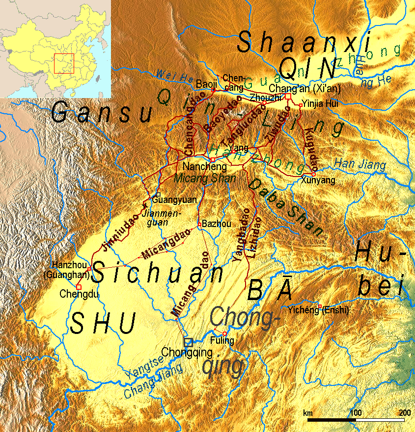
The Daba Mountains, also known by their Chinese name as the Dabashan, are a mountain range in Central China between the watersheds of the Yellow and Yangtze Rivers. Part of the larger Qinling mountain range, it cuts through four provinces: Sichuan, Chongqing, Shaanxi, and Hubei. It spans about 1000 km.
Geography
The Daba Mountains run in the general west-northwest to east-southeast direction, along the border between, on the one side (southwest and south) Sichuan and Chongqing, and on the other side (northeast and north) Shaanxi and Hubei. The mountains of Shennongjia are often considered the easternmost section of the Daba Range.
The southern slope of the Daba Mountains drains into the Sichuan Basin or directly into the Yangtze via short streams that flow into the river in the Three Gorges area, such as the Shen Nong Stream. The northern side drains into the Han River, a major tributary of the Yangtze, which, however, does not join the Yangtze until some hundreds kilometers to the east (in Wuhan).
The Daba Mountains' highest points are in the Shennongjia massif in Shennongjia Forest District. The three tallest peaks, located west of Muyu town, are Shennong Deng ("Shennong Peak", 3105 m elevation), Da Shennongjia ("Great Shennongjia", 3052 m), and Xiao Shennongjia ("Lesser Shennongjia", 3005 m, on the district's border with Badong County). Laojun Shan, 2936 m tall, is located northeast of Muyu.
In the southeast, the Daba Mountains are joined to the Wu Mountains, which block the Yangtze's flow out of the Sichuan Basin. In the east, the small Jingshan Range (in the southern part of the Xiangyang Prefecture) can be viewed as the extreme extension of the Daba Mountains. In the northeast, the Wudang Mountains are nearby; some authors even consider them a "branch" of the Daba Mountains.{{citation
In the rural counties of southern Hanzhong, in Shaanxi Province, there is a large area of karst with some of the largest sinkholes in the world, known as the Shaanxi tiankeng cluster or "Hanzhong tiankeng group". It covers nearly 5019 square kilometers and is located in four counties, Ningqiang County, Nanzheng County, Xixiang County, and Zhenba County, with the largest sinkhole (520 meters in diameter and 320 meters deep), near Sanyuanzhen (三元镇) in Zhenba County.
Natural environment
The natural landscape of the region, the Daba Mountains evergreen forests, is listed by the World Wildlife Fund (WWF) as one of the world's 200 ecoregions that should be a priority for conservation. Dabashan National Nature Reserve is located in the Chongqing part of the Daba Mountains (Chengkou County); Shennongjia Mountain Nature Reserve (704 km2), in Hubei (Shennongjia Forestry District).
The Dawn Redwood (Metasequoia glyptostroboides) is a deciduous conifer endemic to the Daba Shan, whose nearest living relatives are the Coast Redwood and Giant Sequoia of California. Redwoods formerly ranged across the northern hemisphere, but were thought to be extinct outside California until stands of Dawn Redwood were discovered in the Daba Shan in the 1940s.
Flora of the Daba Mountains File:VM 5248 Muyu hills forest mushroom.jpg|A forest mushroom (near Muyu, Shennongjia) File:VM 5356 G209 north of Muyu - bean tree.jpg|Decaisnea insignis (at about 2000 m elevation, north of Muyu) File:VM 5262 Muyu hills forest - blue flowers.jpg|Hosta ventricosa File:VM 5352 G209 north of Muyu - mountain conifer.jpg|Cryptomeria japonica File:VM 5156 G209 Wujiaping to Baishahe (Xingshan County).jpg|Chinese red pine (Pinus tabuliformis), in Xingshan County File:VM 5083 Xiqiuwan xiang Baishawan cun fields.jpg|Cunninghamia lanceolata (center), in Badong County
Land use
Presently, terraced agriculture is expanded in the Daba Mountains. A widely planted cash crop is the Eucommia tree, a medicinal plant.{{citation
Notes
References
References
- (1878). "Encyclopædia Britannica, ''9th ed., Vol. V''".
- "陕西发现天坑群地质遗迹并发现少见植物和飞猫". Sohu.com Inc..
- (25 November 2016). "时事新闻--解密汉中天坑群——改写地质历史的世界级"自然博物馆"". Hanzhong People's Municipal Government.
- {{WWF ecoregion
This article was imported from Wikipedia and is available under the Creative Commons Attribution-ShareAlike 4.0 License. Content has been adapted to SurfDoc format. Original contributors can be found on the article history page.
Ask Mako anything about Daba Mountains — get instant answers, deeper analysis, and related topics.
Research with MakoFree with your Surf account
Create a free account to save articles, ask Mako questions, and organize your research.
Sign up freeThis content may have been generated or modified by AI. CloudSurf Software LLC is not responsible for the accuracy, completeness, or reliability of AI-generated content. Always verify important information from primary sources.
Report