From Surf Wiki (app.surf) — the open knowledge base
Cutler Bay, Florida
Town in the state of Florida, United States
Town in the state of Florida, United States
| Field | Value |
|---|---|
| name | Cutler Bay, Florida |
| settlement_type | Town |
| motto | "An Excellent Place to Live, Work and Play." |
| image_flag | Flag of Cutler Bay.png |
| image_seal | Cutler-bay-florida-seal.png |
| seal_size | 150px |
| image_map | Miami-Dade_County_Florida_Incorporated_and_Unincorporated_areas_Cutler_Ridge_Highlighted.svg |
| map_caption | Location in Miami-Dade County and the state of Florida |
| mapsize1 | 250x200px |
| map_caption1 | U.S. Census Bureau map showing town boundaries |
| subdivision_type | Country |
| subdivision_name | United States |
| subdivision_type1 | State |
| subdivision_name1 | Florida |
| subdivision_type2 | County |
| subdivision_name2 | Miami-Dade |
| established_title | Settled |
| (Cutler Ridge) | |
| established_date | |
| established_title1 | Incorporated (Town of Culter Bay) |
| established_date1 | November 9, 2005 |
| government_type | Council-Manager |
| leader_title | Mayor |
| unit_pref | Imperial |
| area_footnotes | |
| area_total_km2 | 26.64 |
| area_land_km2 | 25.61 |
| area_water_km2 | 1.03 |
| area_total_sq_mi | 10.29 |
| area_land_sq_mi | 9.89 |
| area_water_sq_mi | 0.40 |
| population_as_of | 2020 |
| population_total | 45425 |
| population_footnotes | |
| population_density_km2 | 1773.99 |
| population_density_sq_mi | 4594.42 |
| timezone | EST |
| utc_offset | -5 |
| timezone_DST | EDT |
| utc_offset_DST | -4 |
| coordinates | |
| elevation_footnotes | |
| elevation_ft | 7 |
| postal_code_type | ZIP Codes |
| postal_code | 33157, 33189, 33190 |
| area_codes | 305, 786, 645 |
| blank_name | FIPS code |
| blank_info | 12-15968 |
| blank1_name | GNIS feature ID |
| blank1_info | 2406348 |
| website |
(Cutler Ridge)](settler-colonialism)
Cutler Bay is an incorporated town in Miami-Dade County, Florida, United States, established in 2005. With a population of 45,425 as of the 2020 US census, it is part of the Miami metropolitan area of South Florida. Cutler Bay is the 9th most populous of the 34 municipalities that make up Miami's urban core, and the 33rd most populous of the 163 municipalities.
History
The town was named after Dr. William Cutler of Massachusetts, who visited the area north of the community, around 1880, and encouraged others to settle in what became the pioneer community of Cutler.
The Charles Deering Estate, located in nearby Palmetto Bay, contains the Cutler Fossil Site where mammoths, saber-toothed tigers and California condors are among the many fossil records. The park holds archeological evidence of Native American habitation of the land 10,000 years ago. Tequesta burial mounds are also found there. The area called Cutler Ridge had been called the "Hunting Ground" by some of the earliest Caucasian settlers in the area, circa 1825.
In the early 1900s, the Florida East Coast Railway was extended south to Cutler, which was located near what is now the Charles Deering Estate. Cutler then served as the place where people settling in the undeveloped Homestead area went to get their supplies.
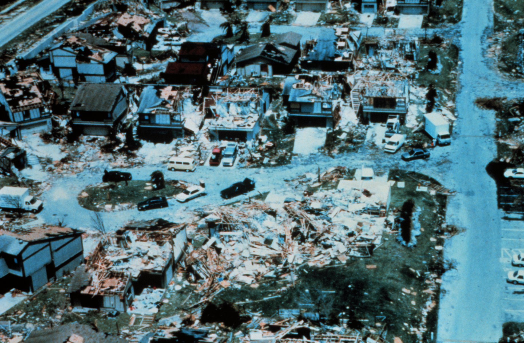
In 1992, Hurricane Andrew made landfall near Cutler Ridge. The storm left the area in "almost total destruction". The dense vegetation near the shore and the dense subdivision development of the area are thought to have been factors which mitigated the extent of areas impacted by flood damage caused by Andrew. However, nearly every building suffered major damage from the wind, and the damage in Florida was estimated at $25 billion, the most expensive natural disaster in US history at the time.
In May 2002, the Cutler Bay Steering Committee company met to discuss the formation of a municipal advisory committee, where the committee would advise on the incorporation of the Cutler Ridge area into the city of Cutler Ridge. The decision to incorporate was spurred in part by the efforts to recover from Hurricane Andrew. The proposed incorporation boundaries included Southwest 184th Street on the north and Southwest 216th and 224th streets on the south. In addition, the west boundary would include Florida's Turnpike, U.S. 1, Southwest 112th Avenue, and Biscayne Bay would serve as the east boundary.
In April 2005, the Charter committee members looked at over a dozen names for the city, ranging from "Pine Ridge" and "Cutler Bay" to just "Cutler". They reduced the choices to "Cutler Ridge" and "Old Cutler Bay". On November 9, 2005, voters approved the charter and chose the name "Cutler Bay" for the county's 35th municipality, over "Cutler Ridge" by a vote of 1,920 to 1,403. In the months following the name change, many of those born and raised in the area that had been known as Cutler Ridge since the 1870s, refused to accept the new name.
Geography
The Town of Cutler Bay is located just west of Biscayne Bay and 18 mi southwest of downtown Miami.
The town's northern border runs from SW 184th Street (Eureka Drive) east of US 1 to the coast. The southern border is SW 232nd Street, north of Black Point Marina, the largest public marina in the Miami area. The town's boundaries include the northeast section of Biscayne National Park, areas formerly known as Cutler Ridge to the west, and the neighborhood and former CDP of Lakes by the Bay to the east. The town is bordered to the north by the village of Palmetto Bay, to the west by unincorporated South Miami Heights, and to the southwest by unincorporated Goulds.
According to the United States Census Bureau, the town of Cutler Bay has a total area of 10.3 sqmi. 9.9 sqmi of it are land and 0.4 sqmi of it (3.87%) are water.
Cutler Ridge, an ancient coral formation, stretches from south Miami, where it rises approximately 22 ft above sea level, through the Cutler Bay area, at a height of 14 ft, to Homestead, Florida, where it is about 8 ft. Cutler Ridge has been incorporated into the hurricane emergency plans for the area as lands east of the ridge are subject to storm surge, but areas west of the ridge would generally be protected.
Due to Cutler Bay's position in a flat, low-lying coastal wetland area on Biscayne Bay, the area is prone to flooding. During the rainy season, Cutler Bay's many canals, channels, and lakes are frequently full of water, and the groundwater table also is full and close to the surface. Flood hazards include rainfall from tropical storms, hurricanes, and other heavy rain events.
Surrounding areas
: Palmetto Bay : West Perrine [[Image:Up arrow left.svg|20px]] [[Image:Up-1.svg|20px]] [[Image:Up arrow right.svg|20px]] Palmetto Bay : Unincorporated Miami-Dade County, South Miami Heights, Goulds [[Image:Left.svg|20px]] [[Image:Right.svg|20px]] Biscayne Bay : Goulds, Princeton [[Image:Down arrow left.svg|20px]] [[Image:Down arrow.svg|20px]] [[Image:Down arrow right.svg|20px]] Lakes by the Bay : Unincorporated Miami-Dade County, Lakes by the Bay
Climate
Cutler Bay has a tropical climate, similar to the climate found in much of the Caribbean. It is part of the only region in the 48 contiguous states that falls under that category. More specifically, it generally has a tropical monsoon climate (Köppen climate classification, Am).
Demographics
|align-fn=center
2010 and 2020 census
| Race | Pop 2010 | Pop 2020 | % 2010 | % 2020 |
|---|---|---|---|---|
| White (NH) | 11,468 | 9,536 | 28.47% | 20.99% |
| Black or African American (NH) | 5,137 | 4,147 | 12.75% | 9.13% |
| Native American or Alaska Native (NH) | 31 | 20 | 0.08% | 0.04% |
| Asian (NH) | 881 | 949 | 2.19% | 2.09% |
| Pacific Islander or Native Hawaiian (NH) | 26 | 12 | 0.06% | 0.03% |
| Some other race (NH) | 149 | 318 | 0.37% | 0.70% |
| Two or more races/Multiracial (NH) | 658 | 1,149 | 1.63% | 2.53% |
| Hispanic or Latino (any race) | 21,936 | 29,294 | 54.45% | 64.49% |
| Total | 40,286 | 45,425 | 100.00% | 100.00% |
As of the 2020 United States census, there were 45,425 people, 13,000 households, and 10,305 families residing in the town.
As of the 2010 United States census, there were 40,286 people, 12,374 households, and 9,124 families residing in the town.
In 2010, the population distribution was: 6.8% under 5 years old, 25.8% under the age of 18, and 10.6% 65 years of age or older. Females were 51.7% of the population. The median income for a household was $61.370. The per capita income for the town was $25,193. About 10.5% of the population were below the poverty line.
According to the latest American Community Survey of 2008–2012 conducted by the US Census Bureau, the percentage of people who spoke English as their main language was of 44.1%, while Spanish speakers were at 50.4% of the population, and other languages accounted for 5.5%.
As of 2000, speakers of English as a first language accounted for 58.89%, while Spanish made up 38.18%, and French Creole comprised 1.31% of the population.
Government and infrastructure
Cutler Bay is governed by a five-member Town Council and operates under a Council-Manager form of government. Three Council Members are elected to represent specific residential areas (Seats 1, 2 & 3) and must reside in their respective area. The Mayor and the Vice Mayor may reside anywhere in the Town. Town Council elections are non-partisan. As the legislative body of the Town, the Town Council determines policy, adopts the annual budget and makes laws. The Miami-Dade Sheriff’s Office operates the South District Station in Cutler Bay.
In January 2006, Cutler Bay elected former Florida state legislator John F. Cosgrove as its first mayor. Mayor Cosgrove died on April 19, 2006, while vacationing in Zimbabwe. Vice Mayor Paul Vrooman assumed the position of Mayor. In November 2010, Edward P. MacDougall was elected Mayor from Vice Mayor. Prior to incorporation Edward MacDougall chaired the municipal charter committee which set the Town's charter. In November 2014, Peggy Bell, who was one of the original Council Members when Cutler Bay was incorporated, was elected Mayor and served as Mayor until she reached her term limits in November 2018. Elected in November 2018, the current office of Mayor is held by former Council member Tim Meerbott.
The community bought an office building, Cutler Bay Town Center, circa 2010; in 2020 the building was about 33% occupied. The city government planned to make money by leasing space in the building, but buyers did not materialize. In 2020, with the support of many residents, the Town traded the building for 16 acre of land, with the vision to transform it into a park and municipal complex.
Education
Primary and secondary schools
Miami-Dade County Public Schools operates public schools.
Elementary schools in the town limits include:
- Bel-Aire Elementary School
- Cutler Ridge Elementary School
- Dr. Edward L. Whigham Elementary School
- Gulfstream Elementary School
- Whispering Pines Elementary School
Cutler Ridge Middle School and Cutler Bay Senior High School are in Cutler Bay.
Prior to 2012, Cutler Bay had two public middle schools (Centennial and Cutler Ridge), and Miami Southridge High School was the zoned public high school. Centennial Middle School was converted into Cutler Bay High School and Cutler Ridge Middle School became the sole middle school of Cutler Bay.
The charter school, Mater Academy Cutler Bay, is in Cutler Bay.
The Roman Catholic Archdiocese of Miami operates Catholic schools. Our Lady of the Holy Rosary-St. Richard School, a K–8 school, is in Cutler Bay.
Colleges and universities
- College of Business and Technology (Cutler Bay Campus)
Media
The Miami Herald provides news coverage for the town under the Cutler Bay heading of its "Miami-Dade Communities" section.
References
References
- "Cutler Bay, Florida". City of North Lauderdale (Website, May 12, 2007-February 21, 2015) via [[Wayback Machine]].
- "2022 U.S. Gazetteer Files: Florida". United States Census Bureau.
- "P1. Race – Cutler Bay town, Florida: 2020 DEC Redistricting Data (PL 94-171)". U.S. Census Bureau.
- {{GNIS. 2406348
- "Population and Housing Unit Estimates".
- "Cutler Bay History".
- Hammer, Roger L.. (May 15, 2005). "A Falconguide to Everglades National Park and the Surrounding Area: A Guide to Exploring the Great Outdoors". Globe Pequot Press.
- Blank, Joan. (1996). "Key Biscayne: A History of Miami's Tropical Island and the Cape Florida Lighthouse". Pineapple Press Inc.
- Green, Jen. (January 1, 2005). "Hurricane Andrew". Gareth Stevens Pub..
- Provenzo, Eugene F. Jr.. (July 1, 1995). "Hurricane Andrew, the Public Schools, and the Rebuilding of Community". SUNY Press.
- Agency, Federal Emergency Management. (April 26, 2013). "Hurricane Andrew in Florida Building Performance Observations, Recommendations, and Technical Guidance". FEMA.
- Roberson, William G.. (September 29, 2014). "Block by Block: The Challenges of Urban Operations". Maroon Ebooks.
- (May 5, 2002). "Ridge Group To Discuss Forming Mac"&p_field_advanced-0=Lead&p_text_advanced-0=(Cutler%20Bay%20Steering%20Committee)&xcal_numdocs=20&p_perpage=10&p_sort=rank:D&xcal_ranksort=4&xcal_useweights=yes). [[Miami Herald]].
- Kemp, Roger L.. (February 21, 2013). "Town and Gown Relations: A Handbook of Best Practices". McFarland.
- (April 13, 2005). "Around Miami-Dade County"&p_field_advanced-0=title&p_text_advanced-0=(Around%20Miami-Dade)&xcal_numdocs=20&p_perpage=10&p_sort=rank:D&xcal_ranksort=4&xcal_useweights=yes). [[Miami Herald]].
- (November 9, 2005). "Cutler Ridge morphed into Cutler Bay on Tuesday"&p_field_advanced-0=&p_text_advanced-0=(morphed)&xcal_numdocs=20&p_perpage=10&p_sort=rank:D&xcal_ranksort=4&xcal_useweights=yes). [[Miami Herald]].
- Yudy Pineiro. (November 10, 2005). "Cutler Bay: 'Ridge Rats' Scoff At Name Change"&p_field_advanced-0=&p_text_advanced-0=(Ridge%20Rat)&xcal_numdocs=20&p_perpage=10&p_sort=rank:D&xcal_ranksort=4&xcal_useweights=yes). [[Miami Herald]].
- (2013). "Homestead, Florida: From Railroad Boom to Sonic Boom". The History Press.
- "Maps Biscayne National Park (U.S. National Park Service)". National Park Service, U.S. Department of the Interior.
- "Cutler Bay Aerial Board - Revised".
- (January 1997). "Hurricane Andrew: South Florida and Louisiana, August 23-26, 1992: Natural Disaster Survey Report". DIANE Publishing.
- "Cutler Bay, FL - Flood Awareness".
- "Köppen Climate Classification Map: South Florida=Aw=tropical wet & dry".
- "U.S. Decennial Census". Census.gov.
- "P2 HISPANIC OR LATINO, AND NOT HISPANIC OR LATINO BY RACE - 2010: DEC Redistricting Data (PL 94-171) - Cutler Bay town, Florida".
- "P2 HISPANIC OR LATINO, AND NOT HISPANIC OR LATINO BY RACE - 2020: DEC Redistricting Data (PL 94-171) - Cutler Bay town, Florida".
- "S1101 HOUSEHOLDS AND FAMILIES - 2020: Cutler Bay town, Florida".
- "S1101 HOUSEHOLDS AND FAMILIES - 2010: Cutler Bay town, Florida".
- "Cutler Bay (town), Florida". U.S. Census Bureau.
- "U.S. Census website". [[United States Census Bureau]].
- "MLA Data Center Results of Cutler Bay (Cutler Ridge,) FL". Epodunk.com.
- "Cutler Bay, FL : Town Council".
- "[http://www.miamidade.gov/mdpd/stations/station_CR_4.asp South District Station] {{Webarchive. link. (2010-01-27 ." [[Miami-Dade Police Department]]. Retrieved on March 12, 2010.)
- (April 18, 2007). "Past National President John Cosgrove enters Chapter Eternal at 56".
- "Cutler Bay has a new mayor and councilman after Tuesday's runoff election".
- "Bell wins mayor's office in Cutler Bay".
- "Archived copy".
- Lefever, Bailey. (January 27, 2020). "Officials hope land swap will help Cutler Bay preserve green space, build new town hall". [[Miami Herald]].
- Stein, Perry. (September 23, 2011). "Cutler Bay On Track for New High School". [[Miami Herald]]}} - Print version: {{cite news.
- "Mater Academy Bay".
- "Zoning Map". Cutler Bay, Florida.
- "Home". Our Lady of the Holy Rosary-St. Richard.
This article was imported from Wikipedia and is available under the Creative Commons Attribution-ShareAlike 4.0 License. Content has been adapted to SurfDoc format. Original contributors can be found on the article history page.
Ask Mako anything about Cutler Bay, Florida — get instant answers, deeper analysis, and related topics.
Research with MakoFree with your Surf account
Create a free account to save articles, ask Mako questions, and organize your research.
Sign up freeThis content may have been generated or modified by AI. CloudSurf Software LLC is not responsible for the accuracy, completeness, or reliability of AI-generated content. Always verify important information from primary sources.
Report