From Surf Wiki (app.surf) — the open knowledge base
Cumings, Texas
| Field | Value | |
|---|---|---|
| official_name | Cumings, Texas | |
| settlement_type | Census-designated place | |
| <!-- | pushpin_map | Texas#USA |
| pushpin_label_position | left | |
| pushpin_map_caption | Location within the state of Texas | |
| pushpin_mapsize | -- | |
| image_map | FortBend County Cumings.svg | |
| mapsize | 300px | |
| subdivision_type | Country | |
| subdivision_name | United States | |
| subdivision_type1 | State | |
| subdivision_name1 | Texas | |
| subdivision_type2 | County | |
| subdivision_name2 | Fort Bend | |
| unit_pref | Imperial | |
| area_total_km2 | 7.57 | |
| area_land_km2 | 7.24 | |
| area_water_km2 | 0.32 | |
| population_as_of | 2020 | |
| population_total | 2207 | |
| population_density_km2 | auto | |
| timezone | Central (CST) | |
| utc_offset | -6 | |
| timezone_DST | CDT | |
| utc_offset_DST | -5 | |
| elevation_m | 26 | |
| elevation_ft | 85 | |
| coordinates | ||
| blank_name | FIPS code | |
| blank_info | 48-18134 | |
| blank1_name | GNIS feature ID | |
| blank1_info | 1852696 |
|
Cumings is an unincorporated community and census-designated place (CDP) in Fort Bend County, Texas, United States. The population was 2,207 at the 2020 census, significantly up from 981 at the 2010 census.
History
The town was established in the early 1990s.
Geography
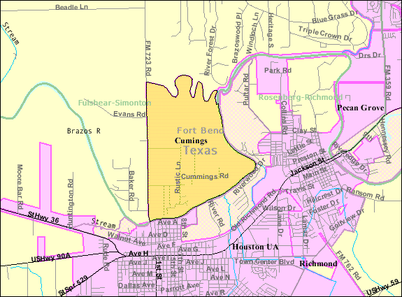
Cumings is located north of the center of Fort Bend County at (29.573483, -95.803286). It is bordered to the south and west by the city of Rosenberg. The southern and eastern edge of Cumings is the Brazos River.
According to the United States Census Bureau, the CDP has a total area of 7.6 km2, of which 7.2 km2 and 0.3 km2, or 4.25%, is water.
Demographics
|align-fn=center 1850–1900 1910 1920 1930 1940
1950 1960 1970 1980 1990 2000 2010 2020
2020 census
| Race / Ethnicity (NH = Non-Hispanic) | title=P004: Hispanic or Latino, and Not Hispanic or Latino by Race – 2000: DEC Summary File 1 – Cumings CDP, Texas | url=https://data.census.gov/table?g=160XX00US4818134&tid=DECENNIALSF12000.P004 | website=United States Census Bureau | access-date= }} | title=P2: Hispanic or Latino, and Not Hispanic or Latino by Race – 2010: DEC Redistricting Data (PL 94-171) – Cumings CDP, Texas | url=https://data.census.gov/cedsci/table?q=p2&g=160XX00US4818134&tid=DECENNIALPL2010.P2 | website=United States Census Bureau | access-date= }} | % 2000 | % 2010 |
|---|---|---|---|---|---|---|---|---|---|---|
| White alone (NH) | 55 | 225 | 840 | 8.05% | ||||||
| Black or African American alone (NH) | 0 | 66 | 264 | 0.00% | ||||||
| Native American or Alaska Native alone (NH) | 0 | 8 | 12 | 0.00% | ||||||
| Asian alone (NH) | 1 | 6 | 58 | 0.15% | ||||||
| Native Hawaiian or Pacific Islander alone (NH) | 0 | 0 | 2 | 0.00% | ||||||
| Other race alone (NH) | 0 | 0 | 5 | 0.00% | ||||||
| Mixed race or Multiracial (NH) | 1 | 2 | 62 | 0.15% | ||||||
| Hispanic or Latino (any race) | 626 | 674 | 964 | 91.65% | ||||||
| Total | 683 | 981 | 2,207 | 100.00% |
2000 census
As of the census of 2000, there were 683 people, 172 households, and 156 families residing in the CDP. The population density was 225.6 PD/sqmi. There were 186 housing units at an average density of 61.4 /sqmi. The racial makeup of the CDP was 60.76% White, 0.29% Asian, 35.43% from other races, and 3.51% from two or more races. Hispanic or Latino of any race were 91.65% of the population.
There were 172 households, out of which 50.6% had children under the age of 18 living with them, 70.9% were married couples living together, 13.4% had a female householder with no husband present, and 9.3% were non-families. 8.1% of all households were made up of individuals, and 2.9% had someone living alone who was 65 years of age or older. The average household size was 3.97 and the average family size was 4.16.
In the CDP, the population was spread out, with 34.8% under the age of 18, 13.0% from 18 to 24, 29.6% from 25 to 44, 16.7% from 45 to 64, and 5.9% who were 65 years of age or older. The median age was 27 years. For every 100 females, there were 98.5 males. For every 100 females age 18 and over, there were 99.6 males.
The median income for a household in the CDP was $36,316, and the median income for a family was $36,776. Males had a median income of $25,847 versus $16,641 for females. The per capita income for the CDP was $10,399. About 24.0% of families and 20.5% of the population were below the poverty line, including 14.7% of those under age 18 and 56.8% of those age 65 or over.
Education
Cumings is within the Lamar Consolidated Independent School District.
Zoned schools include:
- Jackson Elementary School
- Briscoe Junior High School
- Foster High School
The designated community college for LCISD is Wharton County Junior College.
References
References
- "U.S. Census website". [[United States Census Bureau]].
- (2007-10-25). "US Board on Geographic Names". [[United States Geological Survey]].
- (May 2023). "Census Bureau profile: Cumings, Texas". [[United States Census Bureau]].
- (April 2020}}{{cbignore). "Geographic Identifiers: 2010 Demographic Profile Data (G001): Cumings CDP, Texas". U.S. Census Bureau, American Factfinder.
- "Cumings, Texas". Texas State Historical Association.
- (2011-02-12). "US Gazetteer files: 2010, 2000, and 1990". [[United States Census Bureau]].
- "Decennial Census by Decade".
- "1900 Census of Population - Population of Texas By Counties And Minor Civil Divisions".
- "1910 Census of Population - Supplement for Texas".
- "1920 Census of Population - Number of Inhabitants - Texas".
- "1930 Census of Population - Number of Inhabitants - Texas".
- "1940 Census of Population - Number of Inhabitants - Texas".
- "1950 Census of Population - Number of Inhabitants - Texas".
- "1960 Census of Population - Number of Inhabitants - Texas".
- "1970 Census of Population - Number of Inhabitants - Texas".
- "1980 Census of Population - Number of Inhabitants - Texas".
- "1990 Census of Population - Population and Housing Unit Counts - Texas".
- "2000 Census of Population - Population and Housing Unit Counts - Texas".
- "2010 Census of Population - Population and Housing Unit Counts - Texas".
- "P004: Hispanic or Latino, and Not Hispanic or Latino by Race – 2000: DEC Summary File 1 – Cumings CDP, Texas".
- "P2: Hispanic or Latino, and Not Hispanic or Latino by Race – 2010: DEC Redistricting Data (PL 94-171) – Cumings CDP, Texas".
- "P2: Hispanic or Latino, and Not Hispanic or Latino by Race – 2020: DEC Redistricting Data (PL 94-171) – Cumings CDP, Texas".
- "2020 CENSUS - SCHOOL DISTRICT REFERENCE MAP: Fort Bend County, TX". [[U.S. Census Bureau]].
- "[http://www.lcisd.org/DistrictbrInformation/MapofLCISD/ Maps of LCISD]." ''[[Lamar Consolidated Independent School District]]''.
- "High School Attendance Zones". [[Lamar Consolidated Independent School District]].
- [https://statutes.capitol.texas.gov/Docs/ED/htm/ED.130.htm Texas Education Code Sec. 130.211. WHARTON COUNTY JUNIOR COLLEGE DISTRICT SERVICE AREA.]
This article was imported from Wikipedia and is available under the Creative Commons Attribution-ShareAlike 4.0 License. Content has been adapted to SurfDoc format. Original contributors can be found on the article history page.
Ask Mako anything about Cumings, Texas — get instant answers, deeper analysis, and related topics.
Research with MakoFree with your Surf account
Create a free account to save articles, ask Mako questions, and organize your research.
Sign up freeThis content may have been generated or modified by AI. CloudSurf Software LLC is not responsible for the accuracy, completeness, or reliability of AI-generated content. Always verify important information from primary sources.
Report