From Surf Wiki (app.surf) — the open knowledge base
Culverden
Town in Canterbury, New Zealand
Town in Canterbury, New Zealand
| Field | Value |
|---|---|
| name | Culverden |
| settlement_type | town |
| image_skyline | Culverden Main Street 001.JPG |
| image_caption | Mountainview Road (New Zealand State Highway 7) in Culverden |
| area_footnotes | |
| area_total_km2 | 1.04 |
| population_footnotes | |
| population_as_of | |
| population_total | |
| population_density_km2 | auto |
| elevation_m | 179 |
| mapframe | yes |
| mapframe-zoom | 6 |
| coordinates | |
| subdivision_type | Country |
| subdivision_name | New Zealand |
| subdivision_type1 | Region |
| subdivision_name1 | Canterbury |
| subdivision_type2 | Territorial authority |
| subdivision_name2 | Hurunui District |
| subdivision_type3 | Ward |
| subdivision_name3 | West Ward |
| seat_type | Electorates |
| seat | |
| leader_title | Territorial Authority |
| leader_name | Hurunui District Council |
| leader_title1 | Regional council |
| leader_name1 | Environment Canterbury |
| leader_title2 | Mayor of Hurunui |
| leader_name2 | |
| leader_title3 | Kaikōura MP |
| leader_name3 | |
| leader_title4 | Te Tai Tonga MP |
| leader_name4 | |
| timezone1 | New Zealand Standard Time |
| utc_offset1 | +12 |
| timezone1_DST | New Zealand Daylight Time |
| utc_offset1_DST | +13 |
| postal_code_type | Postcode |
| postal_code | 7392 |
| area_code | 03 |
| blank_name | Local iwi |
| blank_info | Ngāi Tahu |
| mapframe-zoom = 6 Culverden is a small town in the northern Canterbury region of New Zealand's South Island. It lies at the centre of the Amuri Plain. Culverden has traditionally been surrounded by sheep farms. Dairy farms have now become more common as a result of irrigation schemes in the area. The Waiau Plains Irrigation Scheme was completed in 1980. It provides irrigation to 17,000 hectares of farmland and the Balmoral Scheme provides irrigation to a further 5500 hectares.
The Health Department encouraged the Amuri County Council to install a water supply in Culverden as a result of a "slight epidemic" of hepatitis which was traced back to contaminated water. A town water supply was built in 1965.
Rubbish collection began in Culverden in 1972. A proposal to provide Culverden with a sewage scheme in 1983 was approved by the Amuri County Council. Residents were unhappy with the cost of it and it was never built. Culverden was still without a sewage scheme in 2000. Culverden had its telephone exchange upgraded to an automatic exchange in 1984. The Bank of New Zealand closed its branch in Culverden in 1988.
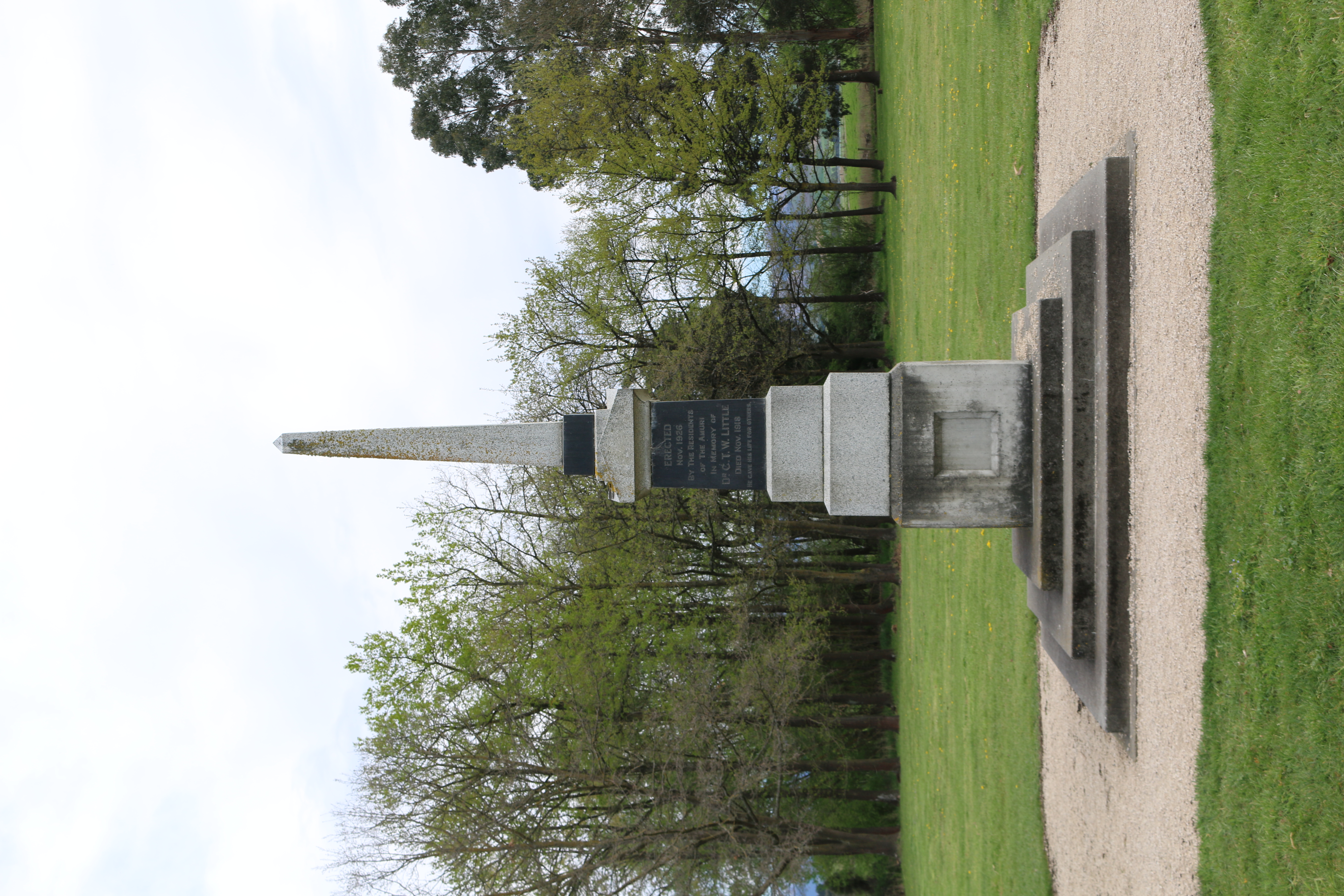
The Rutherford Reserve and the Culverden Recreation Reserve are on the southern side of Culverden and the Culverden Golf Course in on the northern entrance to Culverden. There is a memorial in the Rutherford Reserve to Dr Charles Little who died in November 1918 from the Spanish Flu. He was the county doctor providing medical services from Waikari to Waiau.
Local government
When provincial government was abolished in 1876, Culverden became the main centre for the newly established Amuri County. Counties were abolished in the 1989 local government reforms, and since then, Culverden has belonged to the Hurunui District.
Demographics
Culverden is described by Statistics New Zealand as a rural settlement and covers 1.04 km2. It had an estimated population of as of with a population density of people per km2. Culverden is part of the larger Amuri statistical area.
Culverden had a population of 351 at the 2018 New Zealand census, a decrease of 15 people (−4.1%) since the 2013 census, and an increase of 6 people (1.7%) since the 2006 census. There were 153 households, comprising 159 males and 192 females, giving a sex ratio of 0.83 males per female, with 72 people (20.5%) aged under 15 years, 63 (17.9%) aged 15 to 29, 159 (45.3%) aged 30 to 64, and 54 (15.4%) aged 65 or older.
Ethnicities were 89.7% European/Pākehā, 10.3% Māori, 7.7% Asian, and 1.7% other ethnicities. People may identify with more than one ethnicity.
Although some people chose not to answer the census's question about religious affiliation, 40.2% had no religion, 47.9% were Christian, 0.9% were Buddhist and 3.4% had other religions.
Of those at least 15 years old, 36 (12.9%) people had a bachelor's or higher degree, and 84 (30.1%) people had no formal qualifications. 33 people (11.8%) earned over $70,000 compared to 17.2% nationally. The employment status of those at least 15 was that 150 (53.8%) people were employed full-time, 42 (15.1%) were part-time, and 3 (1.1%) were unemployed.
Amuri statistical area
Amuri statistical area, which includes Culverden, Rotherham and Waiau, covers 1835.61 km2. It had an estimated population of as of with a population density of people per km2.
Amuri had a population of 2,223 at the 2018 New Zealand census, an increase of 126 people (6.0%) since the 2013 census, and an increase of 222 people (11.1%) since the 2006 census. There were 834 households, comprising 1,173 males and 1,047 females, giving a sex ratio of 1.12 males per female. The median age was 34.4 years (compared with 37.4 years nationally), with 507 people (22.8%) aged under 15 years, 417 (18.8%) aged 15 to 29, 1,056 (47.5%) aged 30 to 64, and 246 (11.1%) aged 65 or older.
Ethnicities were 82.9% European/Pākehā, 10.8% Māori, 0.8% Pasifika, 11.3% Asian, and 3.4% other ethnicities. People may identify with more than one ethnicity.
The percentage of people born overseas was 21.7, compared with 27.1% nationally.
Although some people chose not to answer the census's question about religious affiliation, 49.5% had no religion, 40.2% were Christian, 0.1% had Māori religious beliefs, 1.2% were Hindu, 0.3% were Muslim and 2.3% had other religions.
Of those at least 15 years old, 303 (17.7%) people had a bachelor's or higher degree, and 327 (19.1%) people had no formal qualifications. The median income was $38,600, compared with $31,800 nationally. 258 people (15.0%) earned over $70,000 compared to 17.2% nationally. The employment status of those at least 15 was that 1,047 (61.0%) people were employed full-time, 297 (17.3%) were part-time, and 30 (1.7%) were unemployed.
Notable Buildings
Amuri County Offices

This was designed in a Georgian style. It was earthquake damaged and the Hurunui District Council was looking at repairing and strengthening the building. It was for sale in October 2020.
Amuri Co-operating Church
The Amuri Co-operating Church, formerly Saint Andrews Presbyterian Church, Culverden, It has a stained glass window entitled "Christ the Shepherd and Sheep Farmer", designed by Beverley Shore Bennett and executed by Roy Miller in 1973.

Mockett Motors
Mockett Motors is designed in an Art Deco style. The business has been present in Culverden for over 100 years,

Transport
State Highway 7 passes through Culverden, forming the town's main street.
Culvenden was also once an important railway terminus, with the railway line extended from Medbury across the Hurunui River to Culverden on 8 February 1886. It was envisaged that this route would become the Main North Line to Nelson and Blenheim, but a coastal route via Parnassus and Kaikōura was chosen instead. The branch line to Culverden was extended beyond the town to Waiau in 1919 and became known as the Waiau Branch. At the line's peak, when it was considered to be part of the Main North Line, multiple trains ran daily between Culverden and Christchurch, including the Culverden Express and a number of slower mixed trains that carried both freight and passengers. Regular passenger services were replaced by buses on 29 January 1939 and after becoming uneconomic, the railway through Culverden was closed entirely on 15 January 1978. Little now remains of the town's railway except a loading bank at the site of the old station.
Education
Amuri Area School is the sole school in Culverden, catering for Year 1 to 13 students (ages 5 to 18), with a roll of approximately students.
Notable people
Cricketer Amy Satterthwaite (born 1986) grew up in Culverden.
Sport
The Kaiwara Classic Mountain Bike Race starts in Culverden and Cheviot via the Kaiwara Road.
Climate
|access-date = 19 May 2024}}
References
References
- Lovell-Smith, Margaret. (2000). "Hurunui Heritage The Development of a district 1950-2000". Hurunui District Council.
- "Dr Charles Little".
- Wilson, John. "Canterbury places - Amuri district". [[Te Ara: The Encyclopedia of New Zealand]].
- "ArcGIS Web Application".
- {{NZ census place summary 2018. amuri. Amuri
- {{NZ census 2018. 7023834 and 7023835
- {{NZ census 2018. Amuri (312200). amuri. Amuri
- (2017-11-21). "Hurunui Council applying for funding to fix historic trio of buildings".
- "WS04 - Culverden - St Andrews Church".
- "Mockett Motors (Culverden) - Petrol Station in Culverden, North Canterbury".
- "Amuri Area School Education Review Office Report". [[Education Review Office]].
- "Amy Satterthwaite". blackcaps.
- "Kaiwara Classic".
- (2014-04-17). "A day trip to Cheviot".
This article was imported from Wikipedia and is available under the Creative Commons Attribution-ShareAlike 4.0 License. Content has been adapted to SurfDoc format. Original contributors can be found on the article history page.
Ask Mako anything about Culverden — get instant answers, deeper analysis, and related topics.
Research with MakoFree with your Surf account
Create a free account to save articles, ask Mako questions, and organize your research.
Sign up freeThis content may have been generated or modified by AI. CloudSurf Software LLC is not responsible for the accuracy, completeness, or reliability of AI-generated content. Always verify important information from primary sources.
Report