From Surf Wiki (app.surf) — the open knowledge base
Cruzeiro do Sul, Acre
Municipality of Acre, Brazil

Municipality of Acre, Brazil
| Field | Value | |||||||
|---|---|---|---|---|---|---|---|---|
| name | Cruzeiro do Sul | |||||||
| official_name | Municipality of Cruzeiro do Sul | |||||||
| settlement_type | Municipality | |||||||
| nickname | Land of the Nahuas () | |||||||
| image_skyline | Centro de Cruzeiro do Sul-AC.jpg | |||||||
| image_caption | City centre, Catedral Nossa Senhora da Glória, alongside Juruá River, Acre, Brazil. | |||||||
| image_flag | Bandeira de Cruzeiro do Sul (Acre).svg | |||||||
| image_seal | Brasão de Cruzeiro do Sul - AC.svg | |||||||
| image_map | Acre Municip CruzeirodoSul.svg | |||||||
| map_caption | Location in Acre | |||||||
| pushpin_map | Brazil | |||||||
| pushpin_label_position | bottom | |||||||
| pushpin_map_caption | Location in Brazil | |||||||
| subdivision_type | Country | |||||||
| subdivision_name | Brazil | |||||||
| subdivision_name1 | North | |||||||
| subdivision_type1 | Region | |||||||
| subdivision_type2 | State | |||||||
| subdivision_name2 | Acre | |||||||
| leader_title | Mayor | |||||||
| leader_name | Ilderlei Cordeiro (MDB) | |||||||
| established_title | Founded | |||||||
| established_date | September 12, 1904 | |||||||
| unit_pref | Metric | |||||||
| area_total_km2 | 7924.943 | |||||||
| area_land_km2 | ||||||||
| population_as_of | 2020 est | |||||||
| population_total | 89,072 | |||||||
| population_density_km2 | 8.94 | |||||||
| population_demonym | cruzeirense | |||||||
| timezone | ACT | |||||||
| utc_offset | −5 | |||||||
| coordinates | ||||||||
| elevation_footnotes | ||||||||
| elevation_m | 182 | |||||||
| postal_code_type | CEP postal code | |||||||
| postal_code | 69980-000 | |||||||
| area_code_type | Area code | |||||||
| area_code | +55 68 | |||||||
| blank_name | HDI (2010) | |||||||
| blank_info | 0.664 – medium{{Cite web | title=Archived copy | url=http://www.pnud.org.br/arquivos/ranking-idhm-2010.pdf | url-status=dead | archive-url=https://web.archive.org/web/20140708233352/http://www.pnud.org.br/arquivos/ranking-idhm-2010.pdf | archive-date=July 8, 2014 | access-date=August 1, 2013 | publisher=United Nations Development Programme (UNDP) |
| website |
Cruzeiro do Sul (, Southern Cross) is a municipality located on the Juruá river in the west of the Brazilian state of Acre. It is the second-largest city in Acre.
It is bordered to the north by the state of Amazonas, to the south by Peru, to the east by the municipality of Porto Walter, to the west by the municipality of Rodrigues Alves, to the northwest by the municipality of Tarauacá, and to the northwest by the municipality of Mâncio Lima.
The municipality contains 23% of the 846633 ha Serra do Divisor National Park, created in 1989.{{citation|ref=|language=Portuguese
Economy and buildings
The principal economic activity of the municipality is rubber extraction and export, as it was in the majority of the state of Acre. This business attracted many immigrants in the 20th century, including Germans. Of lesser importance is the farming of the commodities of cassava, coffee and rice. The city also operates as a regional trading center.
One of the city's most notable 20th-century structures is the Catedral Nossa Senhora da Glória. The parish was founded in 1915 by Spiritan priests, who established the first church in the Juruá valley. With more settlers, the territory was divided in 1930 and German priests were assigned to this area of the Upper Juruá.
Their influence was shown in the design of the current cathedral, which was begun in 1957; it opened in 1965. Its roof structure is said to be similar to a church in Cologne, Germany. The roof was constructed on site and raised by the workers. In 2015 the parish's centenary was celebrated with an exhibition of historic photographs and related lectures.
Transport
The town is served by Cruzeiro do Sul International Airport. The town is about 630 kilometres from Rio Branco by road, through the BR-364.{{cite web | trans-title= | url-status=dead | author-link= | access-date=6 September 2010 | archive-url=https://web.archive.org/web/20160303175236/http://www.ac.gov.br/wps/portal/acre/Acre/estado-acre/municipios/!ut/p/c5/rZHbcoIwEIafxRcgG0gCvQQJgQgoGDxww1Cn0wGLOlNHRp6-8aZTdcqVu5fffjn8i0qk-1Bfms_63BwP9RfaoJJVM8IWq5nAIITnQzSNo0gpH2xONd-yCv4pF-7tzOLaXnhukUoMYL7C_uWOTBzN8SpI00iCZd7ZTjDX1FxOp7GtYObBg_18-ri9Rhsg1bK9nqJhP-TtkOHUD5LlEPWJH8wV319TfpJJ64LiR_OsXDjzHpKhuML3m35kxt2QrKxuN3n8x9Nd4xtY33Y2nsONj6U85ueA0vDYfaAtKu2_eXHQU0oIiHNLCILUCxORqGzeO6PfdQYYDFuUMkIJozZ1MNpIdOoKXZeY5WGPnX7yA4sdl2c!/dl3/d3/L2dBISEvZ0FBIS9nQSEh/ | archive-date=3 March 2016 | editor-first=
Geography
The urban area of Cruzeiro do Sun has a size of 24.794 km².
Climate
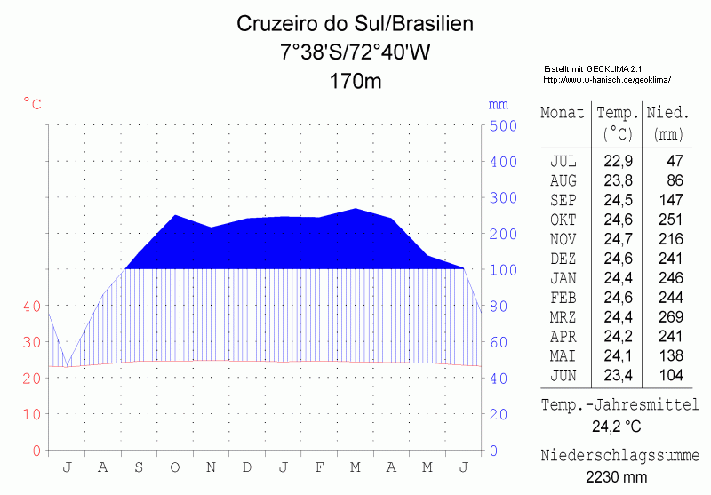
Although the town has a tropical climate typical of Acre and the Amazon region (Köppen Am, bordering on Af as July receives just under 60 mm of rainfall) it is notable for sporadic cold spells not typically found in low-lying equatorial areas. The temperature has twice dropped below 2.4 C, once in May and once in November. The coldest temperature ever recorded is 2.2 C and the warmest is 43.3 C. The warmest month by average temperature is October at 26.0 C, while the warmest month by average high is September at 32.8 C. The coolest months by the average temperature are June and July at 24.8 C, while the coolest month by average low is July at 18.6 C. The average annual temperature is 25.6 C. The average high temperature is 31.8 C, and all months have an average high above 30 C. This, combined with the high humidity year-round, leads to sweltering days.
Cruzeiro do Sul receives 2167.4 mm on average annually and has a wet season that generally falls between October and April and a drier season from June to September. March, receiving 292.6 mm of rainfall on average, is the wettest month, while July is the driest month, receiving only 59.1 mm of rainfall. The wet season has 14-18 precipitation days on average, while the dry season has 6-8 precipitation days on average. March has the most precipitation days and July and August have the least. Humidity is high year round, but drops below 80% from July to September. Even for a rainforest location, sunshine is unusually low, with the city only receiving an average of 1337.5 hours of sunshine annually. This is even lower than places such as London. For comparison, Manaus receives 1,774.8 hours of sunshine despite being wetter. Sunshine is lowest from January to March, and it rises during the dry season. July is the sunniest month, receiving 182.3 hours of sunshine.
|Jan record high C = 36.6 |Feb record high C = 36.8 |Mar record high C = 39.0 |Apr record high C = 38.5 |May record high C = 39.9 |Jun record high C = 38.0 |Jul record high C = 37.2 |Aug record high C = 43.3 |Sep record high C = 42.7 |Oct record high C = 38.7 |Nov record high C = 37.8 |Dec record high C = 38.8 |year record high C = 43.3 |Jan record low C = 10.7 |Feb record low C = 10.1 |Mar record low C = 9.8 |Apr record low C = 11.3 |May record low C = 2.3 |Jun record low C = 6.2 |Jul record low C = 7.1 |Aug record low C = 6.9 |Sep record low C = 6.8 |Oct record low C = 8.1 |Nov record low C = 2.2 |Dec record low C = 10.3 |year record low C = 2.2 | access-date = 20 October 2018}} | access-date = 20 October 2018}}
Gallery
File:Cruzeiro do Sul (Acre), Fundo Correio da Manhã - 2.tif|Cruzeiro do Sul in 1906 File:Ponte 15 de novembro, Cruzeiro do Sul (AC).tif|Cruzeiro do Sul in 1909 File:Catedral_de_Nossa_Senhora_da_Glória.jpg|Catedral de Nossa Senhora da Glória, Brazil File:Ponte da União, Cruzeiro do Sul, Acre.jpg|Union Bridge () in Cruzeiro do Sul runs to the state capital Rio Branco, through the BR-364, Brazil File:No_Juruá,setores_produtivo_e_industrial_vivem_nova_realidade_econômica(24525139761).jpg|Maize and coconut plantations are common in and around Cruzeiro do Sul. File:Aeroporto de Cruzeiro do Sul-AC.jpg|Cruzeiro do Sul International Airport, Brazil File:HospitaldoJuruá.jpg|Juruá Hospital
References
References
- "IBGE - Cidades". [[Instituto Brasileiro de Geografia e Estatística.
- Carvalho, Adelcimar. (8 October 2015). "Exhibition tells story of centenary parish in Cruzeiro do Sul in AC". Acre (Globo.com).
- "Cruzeiro do Sul Airport".
- (15 October 2019). "Aeródromos".
- "Urbanização das cidades brasileiras". [[Embrapa Monitoramento por Satélite]].
- "Station Manaus". Meteo Climat.
This article was imported from Wikipedia and is available under the Creative Commons Attribution-ShareAlike 4.0 License. Content has been adapted to SurfDoc format. Original contributors can be found on the article history page.
Ask Mako anything about Cruzeiro do Sul, Acre — get instant answers, deeper analysis, and related topics.
Research with MakoFree with your Surf account
Create a free account to save articles, ask Mako questions, and organize your research.
Sign up freeThis content may have been generated or modified by AI. CloudSurf Software LLC is not responsible for the accuracy, completeness, or reliability of AI-generated content. Always verify important information from primary sources.
Report