From Surf Wiki (app.surf) — the open knowledge base
Crook County, Wyoming
County in Wyoming, United States

County in Wyoming, United States
| Field | Value |
|---|---|
| county | Crook County |
| state | Wyoming |
| ex image | Crook County Wyoming Courthouse (Sundance).jpg |
| ex image cap | Crook County Courthouse |
| flag | Flag of Crook County, Wyoming.gif |
| founded | December 8, 1875 (authorized) |
| 1888 (organized) | |
| seat wl | Sundance |
| largest city | Sundance |
| city type | town |
| area_total_sq_mi | 2865 |
| area_land_sq_mi | 2854 |
| area_water_sq_mi | 11 |
| area percentage | 0.4% |
| population_as_of | 2020 |
| population_total | 7181 |
| pop_est_as_of | 2024 |
| population_est | 7775 |
| density_sq_mi | auto |
| web | www.crookcounty.wy.gov |
| time zone | Mountain |
| district | At-large |
| named for | George Crook |
1888 (organized)
History
Crook County was created by the legislature of the Wyoming Territory on December 8, 1875, from portions of Albany and Laramie Counties. It was organized in 1888.
Crook County was named for Brigadier General George Crook, an army commander during the Indian Wars. In 1890, Crook County lost territory when Weston County was created. Campbell County was formed with land ceded by Crook County in 1911.
Geography
According to the US Census Bureau, the county has a total area of 2865 sqmi, of which 2854 sqmi is land and 11 sqmi (0.4%) is water. The lowest point in the state of Wyoming is located on the Belle Fourche River in Crook County, where it flows out of Wyoming and into South Dakota.
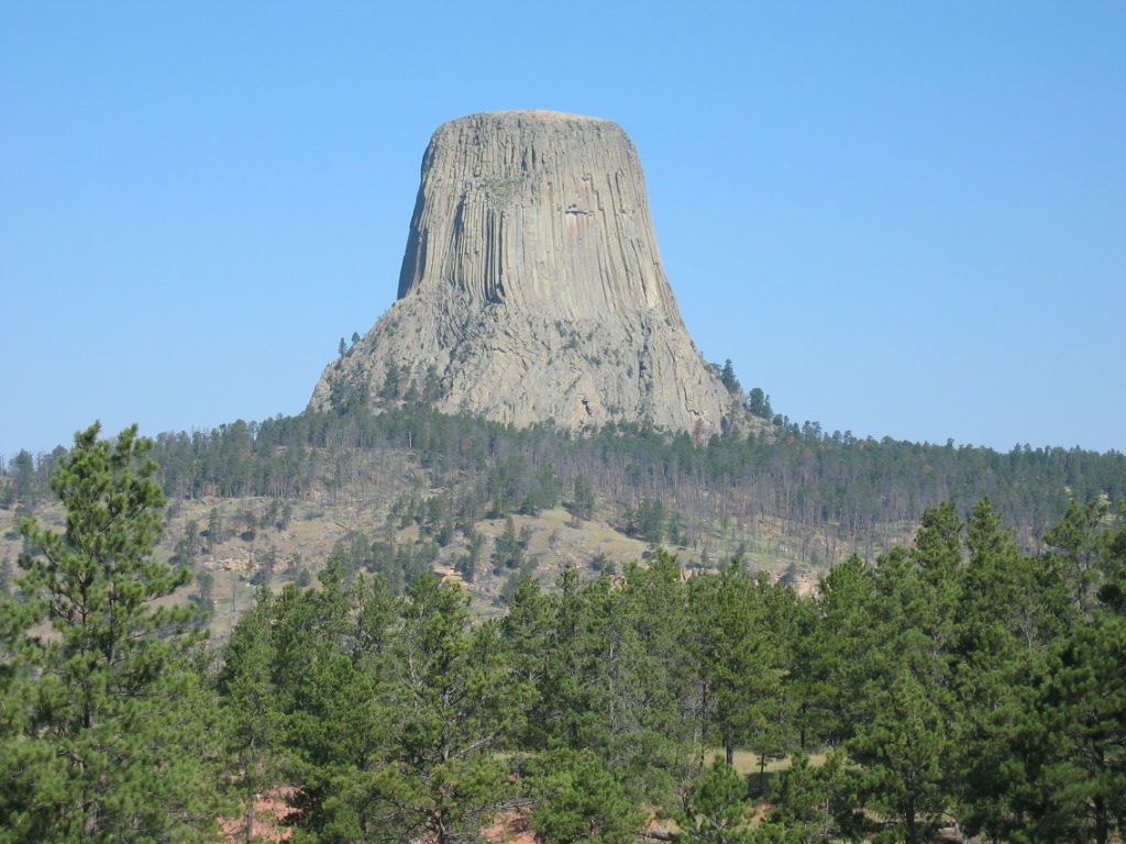
Devils Tower National Monument is located in the Bear Lodge Mountains in Crook County.
The Missouri Buttes, at the northwestern end of the Black Hills, are located in the county, 3.5 miles northwest of Devils Tower.
Major highways
- [[Image:I-90.svg|20px]] Interstate 90
- [[Image:US 14.svg|20px]] U.S. Highway 14
- [[Image:US 16.svg|20px]] U.S. Highway 16
- [[Image:US 212.svg|20px]] U.S. Highway 212
- [[Image:WY-24.svg|20px]] Wyoming Highway 24
- [[Image:WY-51.svg|20px]] Wyoming Highway 51
- [[Image:WY-111.svg|20px]] Wyoming Highway 111
- [[Image:WY-112.svg|20px]] Wyoming Highway 112
- [[Image:WY-113.svg|20px]] Wyoming Highway 113
- [[Image:WY-116.svg|20px]] Wyoming Highway 116
- [[Image:WY-585.svg|20px]] Wyoming Highway 585
Adjacent counties
- Butte County, South Dakota – northeast
- Lawrence County, South Dakota – east
- Weston County – south
- Campbell County – west
- Powder River County, Montana – northwest
- Carter County, Montana – north
National protected areas
- Black Hills National Forest (part)
- Devils Tower National Monument
- Thunder Basin National Grassland (part)
Demographics
| align-fn = center 1870–2000 2010–2016
2020 census
As of the 2020 census, the county had a population of 7,181. Of the residents, 24.4% were under the age of 18 and 23.9% were 65 years of age or older; the median age was 45.5 years. For every 100 females there were 102.3 males, and for every 100 females age 18 and over there were 102.6 males.
The racial makeup of the county was 94.6% White, none Black or African American, 0.8% American Indian and Alaska Native, 0.2% Asian, 0.6% from some other race, and 3.8% from two or more races. Hispanic or Latino residents of any race comprised 1.6% of the population.
There were 2,943 households in the county, of which 26.2% had children under the age of 18 living with them and 18.1% had a female householder with no spouse or partner present. About 27.1% of all households were made up of individuals and 14.4% had someone living alone who was 65 years of age or older.
There were 3,672 housing units, of which 19.9% were vacant. Among occupied housing units, 82.3% were owner-occupied and 17.7% were renter-occupied. The homeowner vacancy rate was 2.0% and the rental vacancy rate was 12.7%.
2010 census
As of the 2010 United States census, there were 7,083 people, 2,921 households, and 2,016 families in the county. The population density was 2.5 /mi2. There were 3,595 housing units at an average density of 1.3 /mi2. The racial makeup of the county was 97.2% white, 0.7% American Indian, 0.2% black or African American, 0.2% Asian, 0.6% from other races, and 1.2% from two or more races. Those of Hispanic or Latino origin made up 2.0% of the population.
Of the 2,921 households, 28.4% had children under the age of 18 living with them, 59.2% were married couples living together, 6.5% had a female householder with no husband present, 31.0% were non-families, and 25.0% of all households were made up of individuals. The average household size was 2.41 and the average family size was 2.90. The median age was 43.6 years.
The median income for a household in the county was $49,890 and the median income for a family was $55,765. Males had a median income of $47,821 versus $32,217 for females. The per capita income for the county was $24,520. About 6.5% of families and 7.8% of the population were below the poverty line, including 10.8% of those under age 18 and 8.0% of those age 65 or over.
2000 census
As of the 2000 United States census, of 2000, there were 5,887 people, 2,308 households, and 1,645 families in the county. The population density was 2 /mi2. There were 2,935 housing units at an average density of 1.0 /mi2. The racial makeup of the county was 97.86% White, 0.05% Black or African American, 1.02% Native American, 0.07% Asian, 0.25% from other races, and 0.75% from two or more races. 0.92% of the population were Hispanic or Latino of any race. 34.1% were of German, 14.6% English, 7.8% Irish and 6.8% American ancestry.
There were 2,308 households, out of which 32.30% had children under the age of 18 living with them, 62.30% were married couples living together, 5.40% had a female householder with no husband present, and 28.70% were non-families. 24.90% of all households were made up of individuals, and 10.30% had someone living alone who was 65 years of age or older. The average household size was 2.51 and the average family size was 3.01.
The county population contained 26.90% under the age of 18, 6.60% from 18 to 24, 24.60% from 25 to 44, 27.20% from 45 to 64, and 14.70% who were 65 years of age or older. The median age was 40 years. For every 100 females there were 102.40 males. For every 100 females age 18 and over, there were 101.80 males.
The median income for a household in the county was $35,601, and the median income for a family was $43,105. Males had a median income of $34,483 versus $18,967 for females, indicating a relatively high level of income inequality based on gender. The per capita income for the county was $17,379. About 7.8% of families and 9.10% of the population were below the poverty line, including 9.90% of those under age 18 and 11.80% of those age 65 or over.
Politics
Crook County is an overwhelmingly Republican county, both in state and federal elections. The last Democratic candidate to carry the county was Franklin D. Roosevelt in 1932, and indeed Roosevelt in the following election – when he lost to Alf Landon by six percentage points – constitutes the last Democrat to pass forty percent. In the last 12 Presidential elections the Democratic candidate has consistently received less than 23.5% of the county's vote. In the 21st century, no Democrat has won even 17% of the vote and every Republican has won over 80% of the vote. In 2016, Crook County was the most Republican county in the most Republican state.
In the Wyoming Senate the county is represented by Republican Ogden Driskill since 2011. In the Wyoming House of Representatives it has been represented by Republican Chip Neiman since 2021.
Communities
Towns
- Hulett
- Moorcroft
- Pine Haven
- Sundance (county seat)
Census-designated place
- Beulah
Unincorporated communities
- Aladdin
- Alva
- Carlile
- Colony
- Devils Tower
- Farrall
- Moskee
- New Haven
- Oshoto
- Sand Creek Crossing
- Stroner
References
References
- "State & County QuickFacts". US Census Bureau.
- "Find a County". National Association of Counties.
- (2004). "Wyoming: Individual County Chronologies". The [[Newberry Library]].
- Urbanek, Mae. (1988). "Wyoming Place Names". Mountain Press Pub. Co..
- Hein, Rebecca. (November 8, 2014). "Campbell County, Wyoming".
- (August 22, 2012). "2010 Census Gazetteer Files". US Census Bureau.
- "QuickFacts".
- "US Decennial Census". US Census Bureau.
- "Historical Decennial Census Population for Wyoming Counties, Cities, and Towns". Wyoming Department of Administration & Information, Division of Economic Analysis.
- (2021). "2020 Decennial Census Demographic Profile (DP1)".
- (2021). "2020 Decennial Census Redistricting Data (Public Law 94-171)".
- "Profile of General Population and Housing Characteristics: 2010 Demographic Profile Data". US Census Bureau.
- "Population, Housing Units, Area, and Density: 2010 - County". US Census Bureau.
- "Selected Social Characteristics in the US – 2006-2010 American Community Survey 5-Year Estimates". US Census Bureau.
- "Selected Economic Characteristics – 2006-2010 American Community Survey 5-Year Estimates". US Census Bureau.
- "U.S. Census website". US Census Bureau.
- "Presidential election of 1932 - Map by counties".
- [http://elections.nytimes.com/2008/results/president/map.html?scp=1&sq=%22election%20map&st=cse The New York Times electoral map (Zoom in on Wyoming)]
- Leip, David. "Atlas of US Presidential Elections".
- "State of Wyoming Legislature{{!}}Ogden Driskill".
- Neiman, Chip. (January 12, 2021). "House District 01: Representative Chip Neiman".
- [https://www.google.com/maps/place/Colony,+WY+82710/@44.8667188,-104.1563689,15z/data=!3m1!4b1!4m13!1m7!3m6!1s0x53332a16c8096703:0xb8ad14ed54c0ab18!2sCrook+County,+WY!3b1!8m2!3d44.4975617!4d-104.6915298!3m4!1s0x5332658b0e1a9bd7:0xfb2821ca1461826b!8m2!3d44.8668197!4d-104.147644 ''Colony WY'' Google Maps (accessed 10 January 2019)]
- [https://www.google.com/maps/place/Devils+Tower,+WY+82714/@44.5877381,-104.6963864,16z/data=!3m1!4b1!4m13!1m7!3m6!1s0x53332a16c8096703:0xb8ad14ed54c0ab18!2sCrook+County,+WY!3b1!8m2!3d44.4975617!4d-104.6915298!3m4!1s0x533306665439f6d1:0x4d1af79c027015f6!8m2!3d44.5887557!4d-104.6986771 ''Devils Tower WY'' Google Maps (accessed 10 January 2019)]
- [https://www.google.com/maps/place/Farrall,+WY+82729/@44.5838757,-104.2661972,15z/data=!3m1!4b1!4m13!1m7!3m6!1s0x53332a16c8096703:0xb8ad14ed54c0ab18!2sCrook+County,+WY!3b1!8m2!3d44.4975617!4d-104.6915298!3m4!1s0x5332f1987b824d7f:0x6b21f90193bcbbe9!8m2!3d44.5838654!4d-104.2575073 ''Farrall WY'' Google Maps (accessed 10 January 2019)]
- [https://www.google.com/maps/place/Moskee,+WY+82729/@44.27165,-104.1875823,15z/data=!3m1!4b1!4m13!1m7!3m6!1s0x53332a16c8096703:0xb8ad14ed54c0ab18!2sCrook+County,+WY!3b1!8m2!3d44.4975617!4d-104.6915298!3m4!1s0x5332daad96c127eb:0x46702d996501f100!8m2!3d44.2717548!4d-104.1788864 ''Moskee WY'' Google Maps (accessed 10 January 2019)]
- [https://www.google.com/maps/place/Crook+County,+WY/@44.7441498,-104.8534483,15z/data=!4m5!3m4!1s0x53332a16c8096703:0xb8ad14ed54c0ab18!8m2!3d44.4975617!4d-104.6915298 ''New Haven WY'' Google Maps (accessed 10 January 2019)]
- [https://www.google.com/maps/place/Oshoto,+WY+82721/@44.5874824,-104.9465085,15z/data=!3m1!4b1!4m13!1m7!3m6!1s0x53332a16c8096703:0xb8ad14ed54c0ab18!2sCrook+County,+WY!3b1!8m2!3d44.4975617!4d-104.6915298!3m4!1s0x53330ad27789b957:0xff1f50a7ef79d78e!8m2!3d44.5875332!4d-104.9376297 ''Oshoto WY'' Google Maps (accessed 10 January 2019)]
- [https://www.google.com/maps/place/Sand+Creek+Crossing,+WY+82712/@44.413873,-104.1048013,15z/data=!3m1!4b1!4m13!1m7!3m6!1s0x53332a16c8096703:0xb8ad14ed54c0ab18!2sCrook+County,+WY!3b1!8m2!3d44.4975617!4d-104.6915298!3m4!1s0x5332c032a41de0fd:0x22f4e6a6bfe14329!8m2!3d44.4139191!4d-104.0961456 ''Sand Creek Crossing WY'' Google Maps (accessed 10 January 2019)]
- [https://www.google.com/maps/place/Stroner,+WY+82721/@44.7666496,-105.0542903,15z/data=!3m1!4b1!4m13!1m7!3m6!1s0x53332a16c8096703:0xb8ad14ed54c0ab18!2sCrook+County,+WY!3b1!8m2!3d44.4975617!4d-104.6915298!3m4!1s0x533397e4185aa257:0x52553ad4a1a15d03!8m2!3d44.7667244!4d-105.045433 ''Stroner wY'' Google Maps (accessed 10 January 2019)]
This article was imported from Wikipedia and is available under the Creative Commons Attribution-ShareAlike 4.0 License. Content has been adapted to SurfDoc format. Original contributors can be found on the article history page.
Ask Mako anything about Crook County, Wyoming — get instant answers, deeper analysis, and related topics.
Research with MakoFree with your Surf account
Create a free account to save articles, ask Mako questions, and organize your research.
Sign up freeThis content may have been generated or modified by AI. CloudSurf Software LLC is not responsible for the accuracy, completeness, or reliability of AI-generated content. Always verify important information from primary sources.
Report