From Surf Wiki (app.surf) — the open knowledge base
Crescent City, California
City in California, United States

City in California, United States
| Field | Value |
|---|---|
| name | Crescent City, California |
| official_name | City of Crescent City |
| settlement_type | City |
| image_skyline | Crescent City California harbor aerial view.jpg |
| image_flag | Flag of Crescent City, California.jpg |
| image_seal | Crescent city ca seal.png |
| pushpin_map | USA |
| pushpin_label_position | right |
| pushpin_label | Crescent City |
| pushpin_map_caption | Location in the United States |
| pushpin_relief | 1 |
| coordinates | |
| subdivision_type | Country |
| subdivision_name | United States |
| subdivision_type1 | State |
| subdivision_name1 | California |
| subdivision_type2 | County |
| subdivision_name2 | Del Norte |
| established_title | Incorporated |
| established_date | April 13, 1854 |
| government_type | Mayor/Council |
| leader_title | Mayor |
| leader_name | Isaiah Wright |
| leader_title1 | State senator |
| leader_name1 | |
| leader_title2 | Assemblymember |
| leader_name2 | |
| leader_title3 | U. S. rep. |
| leader_name3 | |
| unit_pref | Imperial |
| area_footnotes | |
| area_total_sq_mi | 2.42 |
| area_land_sq_mi | 1.96 |
| area_water_sq_mi | 0.45 |
| area_water_percent | 18.7 |
| elevation_ft | 43 |
| elevation_footnotes | |
| population_as_of | 2020 |
| population_total | 6673 |
| population_density_sq_mi | auto |
| timezone | PST |
| utc_offset | -08:00 |
| timezone_DST | PDT |
| utc_offset_DST | -07:00 |
| postal_code_type | ZIP codes |
| postal_code | 95531, 95532, 95538 |
| area_code_type | Area code |
| area_code | 707, 369 |
| blank_name | FIPS code |
| blank_info | |
| blank1_name | GNIS feature IDs |
| blank1_info | , |
| website | |
| image_map | File:Del Norte County California Incorporated and Unincorporated areas Crescent City Highlighted 0617022.svg |
| map_caption | Location in Del Norte County and the state of California |
| area_total_km2 | 6.25 |
| area_land_km2 | 5.09 |
| area_water_km2 | 1.17 |
| population_density_km2 | 1312.26 |
Crescent City (Tolowa: Taa-’at-dvn; Yurok: Kohpey; Wiyot: Daluwagh) is the only incorporated city in Del Norte County, California, United States, of which it is also the county seat. The city is on the North Coast of California and had a total population of 6,673 in the 2020 census, down from 7,643 in the 2010 census.
The city is the site of the Redwood National Park headquarters, as well as the historic Battery Point Light. Due to the richness of the local Pacific Ocean waters and the related catch, and ease of access, Crescent City Harbor serves as home port for numerous commercial fishing vessels. The population includes inmates at Pelican Bay State Prison, also within the city limits, and the former census-designated place Crescent City North annexed to the city.
Crescent City's offshore geography makes it unusually susceptible to tsunamis. In 1964, much of the city was destroyed by four tsunami waves generated by the Great Alaskan earthquake off Anchorage, Alaska. In 2011, the city's harbor suffered extensive damage and destruction from tsunamis generated by the March 11, 2011, earthquake off Sendai, Japan. Several dozen vessels and many of the docks they were moored to were destroyed as wave cycles related to the tsunamis exceeded 8 ft.
History
Crescent City was founded on the site of Tolowa Indian Settlements at Battery Point, Pebble Beach, south of Point St. George, and north of Point St. George. In Tolowa: Taa-’at-dvn. In the Yurok it is Kohpey, and in Wiyot: Daluwagh).
In 1855, the U.S. Congress authorized the building of a lighthouse at "the battery point" (a high tide island on the coast of Crescent City) which is still functioning as a historical landmark.
Europeans began moving to the area in the 1850s. Crescent City was incorporated as a city in 1854.
The population includes inmates at Pelican Bay State Prison, also within the city limits although discontiguous and some ten miles away, and most of the former census-designated place Crescent City North annexed to the city prior to the 2010 U.S. census.
The city is also the site of the Redwood National Park headquarters, as well as the historic Battery Point Light.
Due to the richness of the local Pacific Ocean waters and the related catch, and ease of access, Crescent City Harbor serves as home port for numerous commercial fishing vessels.
Namesake ships
Crescent City was a 113 t schooner built in 1848 by Joshua T. Foster of Medford, Massachusetts.
A 1906 ship named Crescent City was the former Jim Butler, a 701 t steam schooner built by Lindstrom Shipbuilding Company in Aberdeen, Washington, that wrecked in the Channel Islands, off Santa Cruz Island, in 1927.
Shipwrecks
Two notable shipwrecks happened off the coast, in 1865 and then at the start of World War II in December 1941, when a Japanese submarine hit a US oil tanker.
The Brother Jonathan, a paddle steamer, crashed on an uncharted rock near Point St. George, off the coast of Crescent City, California, on July 30, 1865.
The SS Emidio, a 6912 t tanker of the General Petroleum Corporation (later Mobil Oil), was the first casualty of the Imperial Japanese Navy's submarine force action on California's Pacific Coast on December 20, 1941. The damaged tanker broke up on the rocks off Crescent City. The remaining pieces of the ship are now California Historical Landmark #497.
Geography
According to the United States Census Bureau, the city has a total area of 2.415 sqmi, of which 1.963 sqmi (81.3%) is land and 0.452 sqmi (18.7%) is water. Fishing and crabbing, tourism, and timber are the major sources of income in Del Norte County. Elk Creek flows into the Pacific Ocean at Crescent City. Its nearest Californian place of any size to its interior is Happy Camp separated by roughly 42 mi by air, but, due to the unsuitable terrain, it is much farther by road. The nearest city is fellow coastal city Brookings, Oregon, around 20 mi to its north. The Humboldt Bay area encompassing Eureka and Arcata is more than 60 mi to its south. Crescent City is as far north in latitude as Chicago, Middle Island in Ontario, Canada, as well as New England on the Atlantic side. It is as much as nine degrees latitude north of San Diego at the southern tip of the state. Crescent City is closer to Vancouver, Canada (838 km) than to Los Angeles (1003 km).

Climate
Crescent City has a warm-summer Mediterranean climate (Köppen Csb) while under the Trewartha system, it is labeled an oceanic climate (Dobk). The wettest months are from October to March; the wettest month is December with 11.14 in and the driest month is July with 0.33 in. The average high and low temperatures in December are 55 °F and 41 °F. The average high and low temperatures in August are 64 °F and 53 °F. On average, four mornings each winter fall below 32 °F.
The highest temperature recorded in Crescent City was 97 °F on September 20, 1989, and September 21, 1939. The lowest temperature on record was 19 °F on January 20, 1937, and December 21, 1990. The maximum monthly precipitation was 31.25 in in November 1973. The wettest "rain year" was from July 1937 to June 1938 when 107.74 in fell and the driest from July 2013 to June 2014 with 33.58 in. The maximum 24-hour precipitation was 7.73 in on January 9, 1995. The highest snowfall recorded for any period in 24 hours was 6.0 in on January 26, 1972. The 30-year average annual precipitation in Crescent City has decreased from 64 in in the 1980–2010 period to about 58 in over the 1990–2020 period.
The warmest ever overnight low was 68 F in 1929 and the mean between 1991 and 2020 was at the modest 59 F. Cold winter days are also rare. The coldest daytime temperature was 30 F in 1924, which remains the last time Crescent City did not climb above the freezing point for 24 hours. Between 1991 and 2020, the coldest maximum temperature averaged 44 F.
| Jan avg record high F = 65.5 | Feb avg record high F = 66.2 | Mar avg record high F = 64.3 | Apr avg record high F = 65.6 | May avg record high F = 67.8 | Jun avg record high F = 69.1 | Jul avg record high F = 69.2 | Aug avg record high F = 70.7 | Sep avg record high F = 74.9 | Oct avg record high F = 76.6 | Nov avg record high F = 67.6 | Dec avg record high F = 63.7 | year avg record high F = 80.8 | Jan avg record low F = 33.1 | Feb avg record low F = 33.0 | Mar avg record low F = 34.2 | Apr avg record low F = 36.1 | May avg record low F = 39.2 | Jun avg record low F = 42.1 | Jul avg record low F = 45.3 | Aug avg record low F = 46.4 | Sep avg record low F = 43.5 | Oct avg record low F = 39.0 | Nov avg record low F = 34.7 | Dec avg record low F = 32.7 | year avg record low F = 29.9 |Jan record high F = 75 |Feb record high F = 78 |Mar record high F = 88 |Apr record high F = 86 |May record high F = 89 |Jun record high F = 91 |Jul record high F = 96 |Aug record high F = 95 |Sep record high F = 97 |Oct record high F = 93 |Nov record high F = 80 |Dec record high F = 80 |year record high F = |Jan record low F = 19 |Feb record low F = 23 |Mar record low F = 27 |Apr record low F = 29 |May record low F = 30 |Jun record low F = 32 |Jul record low F = 36 |Aug record low F = 34 |Sep record low F = 33 |Oct record low F = 32 |Nov record low F = 23 |Dec record low F = 19 |year record low F =
Tsunamis


The bathymetry of the sea floor surrounding Crescent City has the effect of focusing tsunamis. According to researchers at Humboldt State University and the University of Southern California, the city experienced tsunami conditions 31 times between the years 1933 and 2008. Although many of these incidents were barely perceptible, eleven events included wave measurements exceeding one meter, four events caused damage, and one event in particular is commonly cited as "the largest and most destructive recorded tsunami to strike the United States Pacific Coast." The area is vulnerable to tsunamis generated by large earthquakes in remote parts of the Pacific Ocean, as well as locally by earthquakes along the Cascadia subduction zone and the Mendocino triple junction.
On March 27, 1964, the Great Alaskan earthquake in the Prince William Sound area, set in motion local landslide tsunamis, as well as a trans-Pacific wave. The tsunami wave travel time to Crescent City was 4.1 hours after the earthquake, but it only produced localized flooding. The second and third waves to hit Crescent City were smaller, but the fourth wave struck with a height of approximately 20 ft after having drawn the harbor out nearly dry. The next morning the damage was counted: 289 buildings and businesses had been destroyed; 1,000 cars and 25 large fishing vessels had been crushed; 12 people were confirmed dead, over 100 were injured, and more were missing; and 60 blocks had been inundated, with 30 city blocks destroyed. Many victims had returned to the area before the fourth wave struck thinking that the event had passed. Although most of the missing were later accounted for, not all were tracked down. Insurance adjusters estimated that the city received more damage from the tsunami on a block-by-block basis than did Anchorage from the initial earthquake.
The tsunami raced down the West Coast with more deaths and destruction, but no other location was hit as hard. Crescent City bore the brunt, due to its offshore geography, position relative to the earthquake's strike-line, underwater contours such as the Cobb Seamount, and the position of rivers near the city. Although houses, buildings, and infrastructure were later rebuilt, years passed before the city recovered from the devastation to lives, property, and its economy. Since the 1980s, a jetty that serves as a breakwater has been protected from normal storm waves by hundreds of Dolos armor units, 38-ton concrete shapes.
Crescent City has not suffered fatalities or significant on-shore damage from a tsunami since 1964. Nevertheless, several Pacific tsunamis have caused significant damage to Crescent City harbor or have led to the evacuation of some parts of the city, and a tsunami-caused fatality occurred in the southern part of Del Norte County in 2011, at the mouth of the Klamath River, near Requa.
On June 14, 2005, the 2005 Eureka earthquake measuring 7.2 on the moment magnitude scale hit 90. mi offshore. An estimated 6,000 people were evacuated when a tsunami warning was issued, and a 26 cm tsunami wave hit the area. On November 15, 2006, the tsunami resulting from the magnitude 8.3 Kuril Islands earthquake reached the Pacific coast of the US and Canada and hit the harbor at Crescent City, causing damage to three docks and several boats. Governor Arnold Schwarzenegger declared a county state of emergency. More serious damage resulted from the tsunami spawned by the March 11, 2011 Tōhoku earthquake, a magnitude 9.0 earthquake that struck Japan. Parts of the city were evacuated, thirty-five boats were destroyed, and the harbor suffered major damage. The reported peak surge was over 8 ft by 9:50am. There were no casualties in Crescent City, though one person was killed when swept out to sea near the mouth of the Klamath River, about 15 miles south of the city, and another five were swept out to sea in southern Oregon, but were quickly rescued. On July 29, 2025, the tsunami resulting from the magnitude 8.8 Kamchatka Peninsula earthquake again resulted in significant damage to the harbor.
Demographics
|align-fn=center 1860–1870 1880-1890 1900 1910 1920 1930 1940 1950 1960 1970 1980 1990 2000 2010 2020
2020
The 2020 United States census reported that Crescent City had a population of 6,673. The population density was 3,399.4 PD/sqmi. The racial makeup of Crescent City was 44.8% White, 10.9% African American, 5.8% Native American, 4.3% Asian, 0.1% Pacific Islander, 26.3% from other races, and 7.7% from two or more races. Hispanic or Latino of any race were 32.7% of the population.
The census reported that 57.3% of the population lived in households, 0.4% lived in non-institutionalized group quarters, and 42.3% were institutionalized.
There were 1,652 households, out of which 33.3% included children under the age of 18, 27.9% were married-couple households, 9.9% were cohabiting couple households, 36.8% had a female householder with no partner present, and 25.4% had a male householder with no partner present. 36.7% of households were one person, and 15.3% were one person aged 65 or older. The average household size was 2.32.
The age distribution was 15.0% under the age of 18, 8.2% aged 18 to 24, 44.8% aged 25 to 44, 21.9% aged 45 to 64, and 10.1% who were 65years of age or older. The median age was 35.2years. For every 100 females, there were 224.1 males.
There were 1,843 housing units at an average density of 938.9 /mi2, of which 1,652 (89.6%) were occupied. Of these, 30.5% were owner-occupied, and 69.5% were occupied by renters.
In 2023, the US Census Bureau estimated that the median household income was $41,131, and the per capita income was $18,254. About 13.8% of families and 19.9% of the population were below the poverty line.
2010
The 2010 United States census reported that Crescent City had a population of 7,643. The population density was 3,164.9/sqmi (1,222.0/km2). The racial makeup of Crescent City was 5,052 (66.1%) White, 910 (11.9%) African American, 370 (4.8%) Native American, 333 (4.4%) Asian, 7 (0.1%) Pacific Islander, 696 (9.1%) from other races, and 275 (3.6%) from two or more races. Hispanic or Latino of any race were 2,342 persons (30.6%).
The Census reported that 4,063 people (53.2% of the population) lived in households, 28 (0.4%) lived in non-institutionalized group quarters, and 3,552 (46.5%) were institutionalized. The very high institutionalized percentage is a result of the presence of Pelican Bay State Prison, which was annexed into the city limits in the 1990s.
There were 1,707 households, out of which 559 (32.7%) had children under the age of 18 living in them, 512 (30.0%) were opposite-sex married couples living together, 314 (18.4%) had a female householder with no husband present, 114 (6.7%) had a male householder with no wife present. There were 170 (10.0%) unmarried opposite-sex partnerships, and 7 (0.4%) same-sex married couples or partnerships. 614 households (36.0%) were made up of individuals, and 229 (13.4%) had someone living alone who was 65 years of age or older. The average household size was 2.38. There were 940 families (55.1% of all households); the average family size was 3.13.
The city population contained 1,107 people (14.5%) under the age of 18, 934 people (12.2%) aged 18 to 24, 3,292 people (43.1%) aged 25 to 44, 1,725 people (22.6%) aged 45 to 64, and 585 people (7.7%) who were 65 years of age or older. The median age was 34.9 years. For every 100 females, there were 250.1 males. For every 100 females age 18 and over, there were 298.5 males.
There were 1,906 housing units at an average density of 789.2/sqmi (304.7/km2), of which 1,707 were occupied, of which 532 (31.2%) were owner-occupied, and 1,175 (68.8%) were occupied by renters. The homeowner vacancy rate was 7.7%; the rental vacancy rate was 4.8%. 1,203 people (15.7% of the population) lived in owner-occupied housing units and 2,860 people (37.4%) lived in rental housing units.
Government
In the California State Legislature, Crescent City is in , and .
In the United States House of Representatives, Crescent City is in .
Education
The public schools of Crescent City are part of the Del Norte County Unified School District, which encompasses all of the public schools in Del Norte County. The following are schools within Crescent City or its immediate vicinity.
- Del Norte High School is the only public high school in Crescent City, located on the northern edge of town. It replaced the earlier high school that was more centrally located, and which remains today as a public-access gymnasium and county offices
- The Bess Maxwell Elementary School is the older of two elementary schools in the northern part of town that are located near the high school. Bess Maxwell serves grades 1–5. In its earlier years, it was a K–6 school
- The Castle Rock Charter School is a K–12 charter school that provides personalized education to students, and is the liaison school for parents who home school their children. It operates the Tah-Ah-Dun American Indian Magnet School to provide for the unique requirements of American Indian students who might be at risk. (Tah-Ah-Dun is the Tolowa name for Crescent City, honoring the Tolowa village that stood on present-day Crescent City.) The school is accredited by the Western Association of Schools and Colleges
- Crescent Elk Middle School is the oldest operating school site in town, centrally located in Crescent City. The site was originally a K–8 school, but slowly shed grade levels to other schools as it became a 4–6 school with a separate 7–8 program, then the 6–8 program that it is today
- Mary Peacock Elementary School is the newer of two elementary schools that are located near the high school. The creation of Pelican Bay State Prison caused an increase in housing demand in the Crescent City area, and an increased school district population. This school was built to address that demand, but is not directly associated with the prison
- Joe Hamilton Elementary School is a K–5 school located near Crescent Elk Middle School. It was founded as a K–3 school
- Pine Grove Elementary School has been a K–5 school for many years. It serves the eastern part of Crescent City
- Sunset High School is another Crescent City high school with its own child care center
Transportation
Highway access is provided by U.S. Route 101, which runs directly through the city, connecting the Oregon Coast to the north and Eureka to the south. U.S. Route 199 begins north of Crescent City and runs northeast to Grants Pass, Oregon. The junction of U.S. Routes 101 and 199 is one of only two junctions of two U.S. Routes in California, the other being the junction of U.S. Routes 6 and 395 in Bishop.
SkyWest Airlines formerly served Del Norte County Airport (also known as Jack McNamara Field) as United Express until April 7, 2015. Most flights connected to San Francisco International Airport. PenAir contracted to begin serving the airport with Saab 340 turboprop aircraft beginning September 15, 2015.
Advanced Air currently operates flights from Crescent City (CEC) to Oakland International Airport (OAK) and Los Angeles-Hawthorne Airport (HHR).
Local public transit is provided by Redwood Coast Transit and by various taxi companies. Crescent City is also served by Curry Public Transit, and POINT.
The Crescent City Harbor serves as a commercial fishing port for salmon, shrimp, tuna, cod, and dungeness crab commercial fishing vessels. The Harbor is also home to multiple fishing- and non-fishing-related businesses and harbor governmental offices. The Crescent City Harbor also has several pleasure boat docks.
Arts and culture
Attractions
- In town
- Battery Point Lighthouse
- Crescent City Harbor
- Del Norte County Historical Society Main Museum
- SS Emidio Memorial
- Nearby
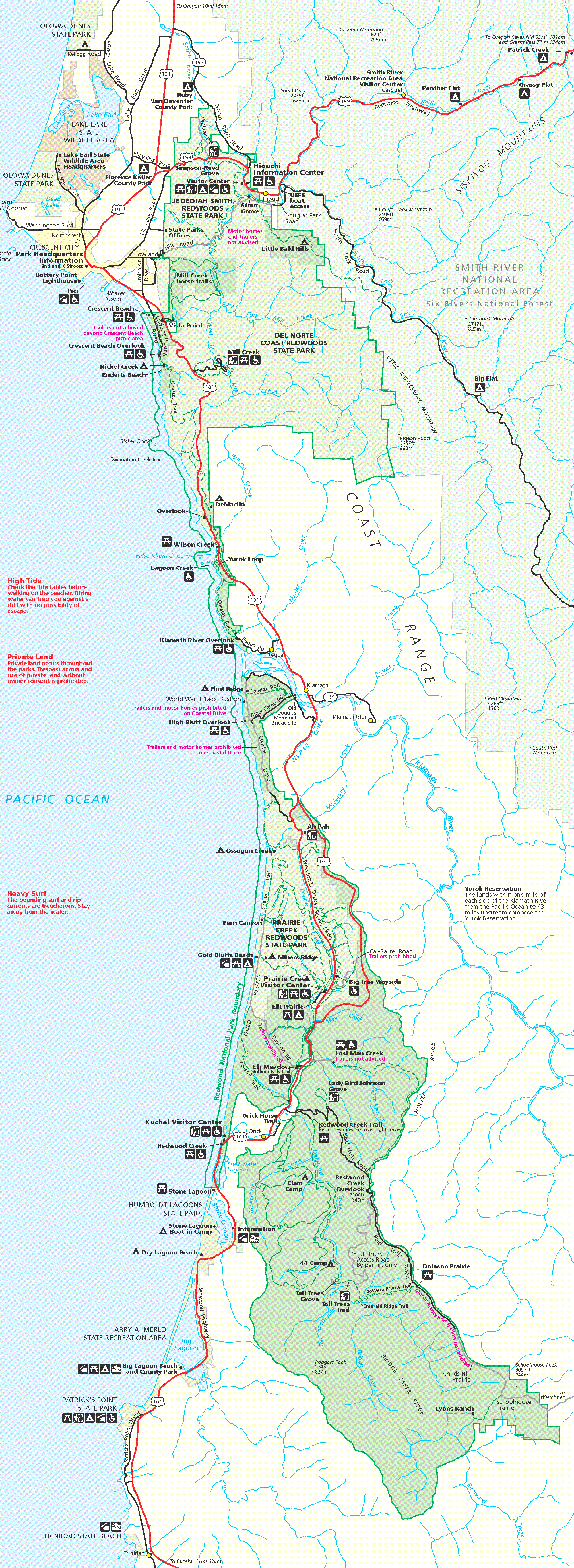
- Del Norte Coast Redwoods State Park
- Jedediah Smith Redwoods State Park
- Lost Monarch (tree)—Largest known Coastal Redwood by volume.
- Pelican Bay State Prison
- Redwood National and State Parks
- St. George Reef Lighthouse
- Smith River National Recreation Area
- Tolowa Dunes State Park
- Trees of Mystery
Annual events
- Fourth of July fireworks display – July
- Sea Cruise Car Show Weekend – Columbus Day Weekend – October
- Forest Moon Festival - A Star Wars themed community festival - First Weekend of May
Notable people
- Eunice Bommelyn – tribal historian and the last person to speak Tolowa as a native first language
- Loren Bommelyn – tradition bearer for the Tolowa tribe
- Donald H. Clausen – American politician
- James F. Curtis – commander of Camp Lincoln
- Louis DeMartin – Del Norte County pioneer
- David Owen Dryden – builder-architect in the craftsman style
- Cody Hoffman – football wide receiver, and multi-record holder, for the football team of Brigham Young University
- Rick Keene - California politician
- Lee Kohse - artist
- Clinton McKinnon - musician (Mr. Bungle)
- Justin Miller – lawyer and a federal appellate judge
- George Peacock, luthier
- Buck Pierce – professional football player, Canadian Football League
- Fred Rinne – visual and performance artist
- Max Steineke – petroleum geologist
- Audrey Wagner – outfielder in the All-American Girls Professional Baseball League
- Wendell Wood – conservationist and environmentalist
International relations
Twin towns – sister cities
Crescent City is twinned with:
- JPN Rikuzentakata, Japan (January 7, 2019)
References
References
- "California Cities by Incorporation Date". California Association of [[Local Agency Formation Commission]]s.
- "City Council". Crescent City, California.
- "Senators". State of California.
- "Assembly Members". State of California.
- {{Cite GovTrack. CA. 2
- "2020 U.S. Gazetteer Files". United States Census Bureau.
- {{Cite GNIS. 277494. Crescent City
- "Siletz Talking Dictionary".
- "Yurok Dictionary: Kohpey".
- "Language; Wiyot Tribe".
- McKinley, Jesse. (March 16, 2011). "Sleepy California Town, and a Tsunami Magnet". [[The New York Times]].
- "Siletz Talking Dictionary".
- "Yurok Dictionary: Kohpey".
- "Language; Wiyot Tribe".
- (2013). "Battery Point, Crescent City CA". Lighthouse Friends.
- (2007). "Crescent City People and Place". National Oceanic and Atmospheres Administration.
- Gleason, Hall. (1937). "Old Ships and Ship-Building Days of Medford". J.C. Miller.
- "Crescent City ship". Puget Sound Maritime Historical Society, University of Washington Libraries.
- "Crescent City, CINMS Shipwreck Database". NOAA / National Marine Sanctuaries.
- Powers, Dennis. (2006). "Treasure Ship: The Legend and Legacy of the S.S. Brother Jonathan". Kensington/Citadel Press.
- Webber, Ebbert. (1975). "Retaliation: Japanese Attacks and Allied Countermeasures on the Pacific Coast in World War II". Oregon State University Press.
- Smith, Christopher. (July 1, 2012). "Del Norte County piers". [[Los Angeles Times]].
- [http://www.movable-type.co.uk/scripts/latlong.html "Distance by Latitude/Longitude" (accessed/calculated 18 October 2019)]
- "NOWData – NOAA Online Weather Data". [[National Oceanic and Atmospheric Administration]].
- "Summary of Monthly Normals 1991–2020". [[National Oceanic and Atmospheric Administration]].
- Dengler, Lori. (September–October 2008). "The Vulnerability of Crescent City CA to Tsunamis Generated by Earthquakes in the Kuril Islands Region of the Northwestern Pacific". Seismological Research Letters.
- "1964 Alaskan Tsunami". University of Southern California.
- Pararas-Carayannis, George. (2007). "The Effects of the March 27, 1964 Alaska Tsunami In California". The Tsunami Page.
- Dennis M. Powers. (January 1, 2005). "The Raging Sea: The Powerful Account of the Worst Tsunami in U.S. History". Citadel Press.
- Silverman, Billy. (March 14, 2011). "Crescent City Tsunami Is 34th Since 1934". Huffington Post Los Angeles.
- "Archived copy".
- (June 15, 2005). "7.0 quake shakes up North Coast / Crescent City residents flee after tsunami warning".
- [https://earthquake.usgs.gov/earthquakes/eqinthenews/2005/usziae/#summary] {{webarchive. link. (December 14, 2009)
- [http://www.dot.ca.gov/hq/esc/earthquake_engineering/PEQIT/2006%20Crescent%20City.pdf Crescent City Suffers Damage from November 15, 2006 Kuril Island Earthquake and Tsunami] {{webarchive. link. (October 4, 2013, California Department of Transportation)
- (2008). "Solutions to Coastal Disasters 2008".
- Tam, Donna, [http://www.times-standard.com/news/ci_17600232 Tsunami takes toll on North Coast; hundreds evacuated, Gov. Brown declares state of emergency] {{webarchive. link. (July 17, 2011, Eureka Times-Standard, March 12, 2011)
- Evert, Barry,[http://www.correctionsone.com/corrections/articles/3421202-Pelican-Bay-Sgt-describes-response-to-Tsunami/ Pelican Bay Sgt. describes response to Tsunami] {{webarchive. link. (March 16, 2011, March 11, 2011, accessed October 4, 2013)
- [http://www.times-standard.com/ci_17592790 Waves destroy Crescent City Harbor docks] {{webarchive. link. (March 11, 2011 , Eureka Times-Standard, March 11, 2011)
- [http://www.wunderground.com/blog/JeffMasters/great-japan-quake-generates-8foot-tsunami-in-california Great Japan quake generates 8-foot tsunami in California] {{webarchive. link. (October 14, 2013, Dr. Jeff Masters' WunderBlog, accessed October 4, 2013)
- Johnson, C.. (March 3, 2011). "Tsunami sweeps 5 to sea, rips out California docks". [[KXTV]].
- (March 11, 2011). "Five swept out to sea, 1 killed as tsunami hits Crescent City CA".
- (March 11, 2011). "Crescent City harbor destroyed; 4 people swept into sea, 1 feared dead". Los Angeles Times.
- LaFever, Matt. (July 31, 2025). "California harbor suffers close to $1 million in damage from tsunami waves". SFGATE.
- "City and Town Population Totals: 2020-2024". United States Census Bureau.
- "Decennial Census by Decade".
- "1870 Census of Population - Population of Civil Divisions less than Counties - California - Almeda County to Sutter County".
- "1870 Census of Population - Population of Civil Divisions less than Counties - California - Tehama County to Yuba County".
- "1890 Census of Population - Population of California by Minor Civil Divisions".
- "1900 Census of Population - Population of California by Counties and Minor Civil Divisions".
- "1910 Census of Population - Supplement for California".
- "1920 Census of Population - Number of Inhabitants - California".
- "1930 Census of Population - Number and Distribution of Inhabitants - California".
- "1940 Census of Population - Number of Inhabitants - California".
- "1950 Census of Population - Number of Inhabitants - California".
- "1960 Census of Population - General population Characteristics - California".
- "1970 Census of Population - Number of Inhabitants - California".
- "1980 Census of Population - Number of Inhabitants - California".
- "1990 Census of Population - Population and Housing Unit Counts - California".
- "2000 Census of Population - Population and Housing Unit Counts - California".
- "2010 Census of Population - Population and Housing Unit Counts - California".
- "Crescent City city, California; DP1: Profile of General Population and Housing Characteristics - 2020 Census of Population and Housing".
- "Crescent City city, California; P16: Household Type - 2020 Census of Population and Housing".
- "Crescent City city, California; DP03: Selected Economic Characteristics - 2023 ACS 5-Year Estimates Comparison Profiles".
- "2010 Census Interactive Population Search: CA – Crescent City city". US Census Bureau.
- "Sunset High School Infant-toddler Center – CRESCENT CITY CA DAY CARE CENTER".
- "UNITED Ends San Francisco – Crescent City Service from April 2015".
- "Fly Crescent City Airlines and Flights".
- Kabir, Shanila. (August 18, 2021). "RV Residents in Crescent City Believe They are Being Wrongfully Evicted During Harbor Project".
- Richard, Terry. (August 14, 2015). "Wendell Wood, 65, remembered as protector of environment". [[The Oregonian]].
- (July 23, 2021). "Sister Cities International Member Crescent City/Del Norte County, California to be Featured During NBC Olympic Coverage".
- (January 7, 2019). "January 7, 2019 Council Agenda". City of Crescent City.
This article was imported from Wikipedia and is available under the Creative Commons Attribution-ShareAlike 4.0 License. Content has been adapted to SurfDoc format. Original contributors can be found on the article history page.
Ask Mako anything about Crescent City, California — get instant answers, deeper analysis, and related topics.
Research with MakoFree with your Surf account
Create a free account to save articles, ask Mako questions, and organize your research.
Sign up freeThis content may have been generated or modified by AI. CloudSurf Software LLC is not responsible for the accuracy, completeness, or reliability of AI-generated content. Always verify important information from primary sources.
Report