From Surf Wiki (app.surf) — the open knowledge base
Crawford County, Pennsylvania
County in Pennsylvania, United States

County in Pennsylvania, United States
| Field | Value |
|---|---|
| ex image | Crawford County Pennsylvania Courthouse.jpg |
| ex image cap | The Crawford County Courthouse in Meadville |
| county | Crawford County |
| state | Pennsylvania |
| flag | Flag of Crawford County, Pennsylvania.png |
| seal | Crawford County PA seal.jpg |
| founded date | March 12 |
| founded year | 1800 |
| seat wl | Meadville |
| largest city wl | Meadville |
| area_total_sq_mi | 1038 |
| area_land_sq_mi | 1012 |
| area_water_sq_mi | 25 |
| area percentage | 2.4% |
| census yr | 2020 |
| pop | 83938 |
| pop_est_as_of | 2024 |
| pop_est_footnotes | |
| population_est | 82089 |
| density_sq_mi | 81 |
| web | www.crawfordcountypa.net |
| time zone | Eastern |
| district | 16th |
| named for | William Crawford |
| footnotes |
Crawford County is a county in the Commonwealth of Pennsylvania. As of the 2020 census, the population was 83,938. Its county seat is Meadville. The county was created on March 12, 1800, from part of Allegheny County and named for Colonel William Crawford. The county is part of the Northwest region of the commonwealth.
Crawford County comprises the Meadville micropolitan statistical area, which is also included in the Erie-Meadville combined statistical area.
Geography
According to the U.S. Census Bureau, the county has a total area of 1038 sqmi, of which 25 sqmi (2.4%) are covered by water. It has a warm-summer humid continental climate (Dfb) and average monthly temperatures in Meadville range from 24.9 °F in January to 69.5 °F in July, while in Titusville they range from 24.2 °F in January to 68.8 °F in July.
Adjacent counties
- Erie County (north)
- Warren County (east)
- Venango County (southeast)
- Mercer County (south)
- Trumbull County, Ohio (southwest)
- Ashtabula County, Ohio (west)
National protected area
- Erie National Wildlife Refuge
State protected area
Pymatuning State Park is on Pymatuning Reservoir.
Major highways
Demographics
| align-fn = center
2020 census
As of the 2020 census, the county had a population of 83,938. The median age was 44.2 years. 20.6% of residents were under the age of 18 and 21.9% of residents were 65 years of age or older. For every 100 females there were 95.4 males, and for every 100 females age 18 and over there were 93.4 males age 18 and over.
The racial makeup of the county was 92.7% White, 1.8% Black or African American, 0.1% American Indian and Alaska Native, 0.4% Asian,
34.2% of residents lived in urban areas, while 65.8% lived in rural areas.
There were 33,930 households in the county, of which 25.1% had children under the age of 18 living in them. Of all households, 47.8% were married-couple households, 19.8% were households with a male householder and no spouse or partner present, and 24.7% were households with a female householder and no spouse or partner present. About 30.8% of all households were made up of individuals and 14.8% had someone living alone who was 65 years of age or older.
There were 42,063 housing units, of which 19.3% were vacant. Among occupied housing units, 72.1% were owner-occupied and 27.9% were renter-occupied. The homeowner vacancy rate was 1.7% and the rental vacancy rate was 7.8%.
| Race / Ethnicity (NH = Non-Hispanic) | title=P004: Hispanic or Latino, and Not Hispanic or Latino by Race – 2000: DEC Summary File 1 – Crawford County, Pennsylvania | url=https://data.census.gov/table/DECENNIALSF12000.P004?q=P004:+HISPANIC+OR+LATINO,+AND+NOT+HISPANIC+OR+LATINO+BY+RACE+[73]&g=050XX00US42039 | publisher=United States Census Bureau | access-date= }} | title=P2 Hispanic or Latino, and Not Hispanic or Latino by Race – 2010: DEC Redistricting Data (PL 94-171) - Crawford County, Pennsylvania | url=https://data.census.gov/table/DECENNIALPL2010.P2?q=p2&g=050XX00US42039 | website=United States Census Bureau}} | % 2000 | % 2010 |
|---|---|---|---|---|---|---|---|---|---|
| White alone (NH) | 87,263 | 84,930 | 77,347 | 96.56% | |||||
| Black or African American alone (NH) | 1,428 | 1,503 | 1,496 | 1.58% | |||||
| Native American or Alaska Native alone (NH) | 174 | 150 | 109 | 0.19% | |||||
| Asian alone (NH) | 254 | 397 | 365 | 0.28% | |||||
| Pacific Islander alone (NH) | 22 | 13 | 26 | 0.02% | |||||
| Other race alone (NH) | 46 | 27 | 229 | 0.05% | |||||
| Mixed race or Multiracial (NH) | 642 | 922 | 3,125 | 0.71% | |||||
| Hispanic or Latino (any race) | 537 | 823 | 1,241 | 0.59% | |||||
| Total | 90,366 | 88,765 | 83,938 | 100.00% |
2000 census
As of the 2000 census, 90,366 people, 34,678 households, and 23,858 families were residing in the county. The population density was 89 /mi2. The 42,416 housing units had an average density of 42 /mi2. The racial makeup of the county was 97.00% White, 1.59% African American, 0.20% Native American, 0.28% Asian, 0.03% Pacific Islander, 0.13% from other races, and 0.77% from two or more races. About 0.59% of the population were Hispanics or Latinos of any race. About 45.1% were self-described English or Welsh, 10.9% American, 10.3% German, 8.2% Irish, 7.8% Scotch-Irish or Scottish, 3.8% Italian 2.6% Dutch, and 2.3% French by ancestry.
Of the 34,678 households, 30.4% had children under 18 living with them, 55.6% were married couples living together, 9.2% had a female householder with no husband present, and 31.2% were not families. About 26.2% of all households were made up of individuals, and 11.6% had someone living alone who was 65 or older. The average household size was 2.50 and the average family size was 3.01.
In the county, the age distribution was 24.7% under 18, 9.2% from 18 to 24, 26.6% from 25 to 44, 23.9% from 45 to 64, and 15.6% who were 65 or older. The median age was 38 years. For every 100 females, there were 94.8 males. For every 100 females age 18 and over, there were 90.8 males.
Micropolitan statistical area
The United States Office of Management and Budget has designated Crawford County as the 'Meadville, PA micropolitan statistical area. As of the 2010 census the micropolitan area ranked fifth-most populous in Pennsylvania and the 52nd-most populous in the United States with a population of 88,765. Crawford County is also a part of the Erie-Meadville combined statistical area, which combines the population of both Crawford County and Erie County. The combined statistical area ranked seventh in Pennsylvania and 102nd-most populous in the United States with a population of 369,331.
]]
Government
Voter registration
- Republican: 29,457 (59.17%)
- Democratic: 14,454 (29.03%)
- Independent: 4,039 (8.11%)
- Third Party: 1,836 (3.69%)
County Commissioners
| Office | Holder | Party |
|---|---|---|
| Commissioner | Eric Henry | Republican |
| Commissioner | Scott T. Schell | Republican |
| Commissioner | Christopher R. Seeley | Democratic |
Other County Row Officers
| Office | Holder | Party |
|---|---|---|
| Clerk of Courts | Patti Wetherbee | Republican |
| County Auditor | Kelsey Zimmerman | Republican |
| County Auditor | Renee Kiser | Republican |
| County Auditor | Darien Pfaff | Democratic |
| County Coroner | Eric Coston | Republican |
| District Attorney | Paula DiGiacomo | Republican |
| Prothonotary | Emmy Arnett | Republican |
| Register & Recorder | Beth M. Forbes | Republican |
| Sheriff | Dave Powers | Republican |
| Treasurer | Chris Krzysiak | Republican |
Pennsylvania Senate
| District | Senator | Party |
|---|---|---|
| 50 | Michele Brooks | Republican |
Pennsylvania House of Representatives
| District | Representative | Party |
|---|---|---|
| 6 | Brad Roae | Republican |
| 17 | Parke Wentling | Republican |
| 65 | Kathy Rapp | Republican |
United States House of Representatives
| District | Representative | Party |
|---|---|---|
| 16 | Mike Kelly | Republican |
United States Senate
| Senator | Party |
|---|---|
| John Fetterman | Democrat |
| Dave McCormick | Republican |
Education
Colleges and universities
- Allegheny College, located in Meadville
- University of Pittsburgh at Titusville, a branch campus of the University of Pittsburgh, located in Titusville
Community, junior, and technical colleges
- Precision Manufacturing Institute (PMI) Laurel Technical Institute (LTI)
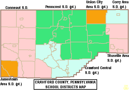
Public school districts
School districts are:
- Conneaut School District
- Corry Area School District
- Crawford Central School District
- Jamestown Area School District
- Penncrest School District
- Titusville Area School District
- Union City Area School District
Communities

Under Pennsylvania law, the four types of incorporated municipalities are: cities, boroughs, townships, and, in at most two cases, towns. The following cities, boroughs, and townships are located in Crawford County:
Cities
- Meadville (county seat)
- Titusville
Boroughs
- Blooming Valley
- Cambridge Springs
- Centerville
- Cochranton
- Conneaut Lake
- Conneautville
- Hydetown
- Linesville
- Saegertown
- Spartansburg
- Springboro
- Townville
- Venango
- Woodcock
Townships
- Athens
- Beaver
- Bloomfield
- Cambridge
- Conneaut
- Cussewago
- East Fairfield
- East Fallowfield
- East Mead
- Fairfield
- Greenwood
- Hayfield
- North Shenango
- Oil Creek
- Pine
- Randolph
- Richmond
- Rockdale
- Rome
- Sadsbury
- South Shenango
- Sparta
- Spring
- Steuben
- Summerhill
- Summit
- Troy
- Union
- Venango
- Vernon
- Wayne
- West Fallowfield
- West Mead
- West Shenango
- Woodcock
Census-designated places
Census-designated places are geographical areas designated by the U.S. Census Bureau for the purposes of compiling demographic data. They are not actual jurisdictions under Pennsylvania law.
- Adamsville
- Atlantic
- Canadohta Lake
- Conneaut Lakeshore
- Fredericksburg
- Geneva
- Guys Mills
- Harmonsburg
- Hartstown
- Kerrtown
- Lincolnville
- Pymatuning Central
- Pymatuning North
- Pymatuning South
- Riceville
Unincorporated communities
- Buells Corners
- Custards
- Frenchtown
- Rundell
Population ranking
The population ranking of the following table is based on the 2010 census of Crawford County.
† county seat
| Rank | City/Town/etc. | Municipal type | Population (2010 Census) |
|---|---|---|---|
| 1 | † Meadville | City | 13,388 |
| 2 | Titusville | City | 5,601 |
| 3 | Cambridge Springs | Borough | 2,595 |
| 4 | Conneaut Lakeshore | CDP | 2,395 |
| 5 | Pymatuning Central | CDP | 2,269 |
| 6 | Cochranton | Borough | 1,136 |
| 7 | Linesville | Borough | 1,040 |
| 8 | Saegertown | Borough | 997 |
| 9 | Conneautville | Borough | 774 |
| 10 | Fredericksburg | CDP | 733 |
| 11 | Conneaut Lake | Borough | 653 |
| 12 | Hydetown | Borough | 526 |
| 13 | Canadohta Lake | CDP | 516 |
| 14 | Pymatuning South | CDP | 479 |
| 15 | Springboro | Borough | 477 |
| 16 | Harmonsburg | CDP | 401 |
| 17 | Blooming Valley | Borough | 337 |
| 18 | Townville | Borough | 323 |
| 19 | Pymatuning North | CDP | 311 |
| T-20 | Spartansburg | Borough | 305 |
| T-20 | Kerrtown | CDP | 305 |
| 21 | Venango | Borough | 239 |
| 22 | Centerville | Borough | 218 |
| 23 | Hartstown | CDP | 201 |
| 24 | Woodcock | Borough | 157 |
| 25 | Guys Mills | CDP | 124 |
| 26 | Geneva | CDP | 109 |
| 27 | Lincolnville | CDP | 96 |
| 28 | Atlantic | CDP | 77 |
| 29 | Riceville | CDP | 68 |
| 30 | Adamsville | CDP | 67 |
Notable people
- The abolitionist John Brown lived in Crawford County for 11 years, more than he lived anywhere else. He was the first postmaster of Randolph Township, a position he held from 1828 to 1836, and he carried the mail from Meadville. In 1825 he started the county's first industry, a tannery, today the John Brown Farm, Tannery & Museum. In his barn, an Underground Railroad station, he had a secret, well-ventilated room in which to hide fugitive slaves. One reason he relocated to Crawford County, he said, was that it was a good location for helping them.
- Robert F. Kent (1911–1982) was born in Meadville and represented Crawford County in the Pennsylvania House of Representatives from 1947 to 1956. He was elected Pennsylvania State Treasurer in 1956 and held this office from January 1957 to January 1961.
References
References
- "Crawford County, Pennsylvania".
- "PHMC Historical Markers Search". Commonwealth of Pennsylvania.
- "Census - Geography Profile: Crawford County, Pennsylvania". [[United States Census Bureau]].
- "Find a County". National Association of Counties.
- Gannett, Henry. (1905). "The Origin of Certain Place Names in the United States". Govt. Print. Off..
- (August 22, 2012). "2010 Census Gazetteer Files". United States Census Bureau.
- "PRISM Climate Group at Oregon State University".
- "Census 2020".
- (2021). "2020 Decennial Census Demographic Profile (DP1)".
- (2021). "2020 Decennial Census Redistricting Data (Public Law 94-171)".
- (2023). "2020 Decennial Census Demographic and Housing Characteristics (DHC)".
- "P004: Hispanic or Latino, and Not Hispanic or Latino by Race – 2000: DEC Summary File 1 – Crawford County, Pennsylvania". [[United States Census Bureau]].
- "P2 Hispanic or Latino, and Not Hispanic or Latino by Race – 2010: DEC Redistricting Data (PL 94-171) - Crawford County, Pennsylvania".
- "P2 Hispanic or Latino, and Not Hispanic or Latino by Race – 2020: DEC Redistricting Data (PL 94-171) - Crawford County, Pennsylvania".
- "U.S. Census website". [[United States Census Bureau]].
- "Office of Management and Budget".
- "2010 U.S. Census website". [[United States Census Bureau]].
- Leip, David. "Dave Leip's Atlas of U.S. Presidential Elections".
- (November 5, 2024). "2024 Senate Election (Official Returns)".
- Pennsylvania Department of State. (February 6, 2024). "Voter registration statistics by county".
- "Precision Manufacturing Institute (PMI)".
- Geography Division. (January 14, 2021). "2020 CENSUS - SCHOOL DISTRICT REFERENCE MAP: Crawford County, PA". [[U.S. Census Bureau]].
- "Member Biography: Robert F. Kent".
This article was imported from Wikipedia and is available under the Creative Commons Attribution-ShareAlike 4.0 License. Content has been adapted to SurfDoc format. Original contributors can be found on the article history page.
Ask Mako anything about Crawford County, Pennsylvania — get instant answers, deeper analysis, and related topics.
Research with MakoFree with your Surf account
Create a free account to save articles, ask Mako questions, and organize your research.
Sign up freeThis content may have been generated or modified by AI. CloudSurf Software LLC is not responsible for the accuracy, completeness, or reliability of AI-generated content. Always verify important information from primary sources.
Report