From Surf Wiki (app.surf) — the open knowledge base
Congo River
River in Central Africa

River in Central Africa
| Field | Value |
|---|---|
| name | Congo River |
| Fleuve Congo | |
| Rio Congo | |
| Mto Kongo | |
| name_other | Zaire River |
| Fleuve Zaïre | |
| Rio Zaire | |
| image | Aerial view of the Congo River near Kisangani.jpg |
| image_size | 300 |
| image_caption | The Congo River near Kisangani, DR Congo |
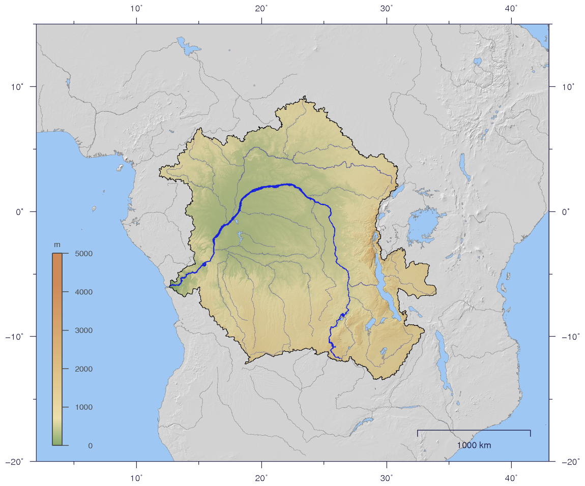
| map | Congobasinmap.png |
| map_size | 300 |
| map_caption | The drainage basin of the Congo River |
| pushpin_map_size | 100.1111111000000034r |
| subdivision_type1 | Country |
| length | 2,300 km |
| Congo–Lualaba <ref name | "Congo River Basin" |
| width_min | 200 m (Lower Congo); 1,440 m (Middle Congo) |
| width_max | 19,000 m (mouth) |
| depth_avg | 12 to (Lower Congo); 5 to (Middle Congo) |
| depth_max | 220 m (Lower Congo); 50 m (Middle Congo) |
| discharge1_location | Banana (near mouth) |
| discharge1_min | 23,000 m3/s |
| discharge1_avg | 1,308 km3/year |
| <ref name | "Hydrological Cycle Volume III" |
| discharge1_max | 75,000 m3/s |
| discharge2_location | Kinshasa, Brazzaville |
| discharge2_min | 22,000 m3/s (1905) |
| discharge2_avg | (Period: 1902–2019)40,500 m3/s |
| (Period: 1947–2023)<ref name | "Congo River: Analysis of suspended sediment flux in a multichannel megasystem in Central Africa" |
| discharge2_max | 77,000 m3/s (1961) |
| discharge3_location | Kisangani |
| discharge3_min | 3,240 m3/s |
| discharge3_avg | (Period: 1951–2012)7,640 m3/s |
| discharge3_max | 13,930 m3/s |
| discharge4_location | Kindu |
| discharge4_min | 640 m3/s |
| discharge4_avg | 2,213 m3/s |
| discharge4_max | 7,640 m3/s |
| discharge5_location | Bukama |
| discharge5_min | 52 m3/s |
| discharge5_avg | 322 m3/s |
| discharge5_max | 1,229 m3/s |
| source1 | Boyoma Falls |
| source1_location | Kisangani |
| source1_coordinates | |
| source1_elevation | 373 m |
| source2 | Lualaba |
| source2_location | Katanga Plateau |
| source2_coordinates | |
| source2_elevation | 1,420 m |
| source3 | Chambeshi |
| source3_coordinates | |
| source3_elevation | 1,760 m |
| mouth | Atlantic Ocean |
| mouth_coordinates | |
| mouth_elevation | 0 m |
| progression | Atlantic Ocean |
| river_system | Congo River |
| basin_size | 4,014,500 km2 |
| tributaries_left | Lubudi, Lovoi, Luvidjo, Kasuku, Lomami, Lulonga, Ikelemba, Ruki, Irebu, Kasai, Lufimi, Inkisi |
| tributaries_right | Lufira, Luvua, Lukuga, Luama, Elila, Ulindi, Lowa, Maiko, Lindi, Aruwimi, Itimbiri, Mongala, Ubangi, Sangha, Likouala, Alima, Nkeni, Léfini, Djoué |
| mapframe | yes |
| mapframe-zoom | 4 |
| mapframe-wikidata | yes |
Fleuve Congo Rio Congo Mto Kongo Fleuve Zaïre Rio Zaire Congo–Lualaba–Luvua–Luapula–Chambeshi 4,700 km; Congo–Lualaba 4,374 km 41,860 m3/s (Period: 1947–2023)41,268 m3/s | mapframe-zoom = 4 | mapframe-wikidata = yes
The Congo River, formerly also known as the Zaire River, is the second-longest river in Africa, shorter only than the Nile, as well as the third largest river in the world by discharge volume, following the Amazon and Ganges–Brahmaputra rivers. It is the world's deepest recorded river, with measured depths of around 220 m. The Congo–Lualaba–Luvua–Luapula–Chambeshi River system has an overall length of 4,700 km, which makes it the world's ninth-longest river. The Chambeshi is a tributary of the Lualaba River, and Lualaba is the name of the Congo River upstream of Boyoma Falls, extending for 1,800 km.
Measured along with the Lualaba, the main tributary, the Congo River has a total length of 4,370 km. It is the only major river to cross the equator twice. The Congo Basin has a total area of about 4,000,000 km2, or 13% of the entire African landmass.
Name
The name Congo/Kongo originates from the Kingdom of Kongo once located on the southern bank of the river. The kingdom in turn was named after the indigenous Bantu Kongo people, known in the 17th century as "Esikongo". South of the Kingdom of Kongo proper lay the similarly named Kakongo kingdom, mentioned in 1535. Abraham Ortelius labelled "Manicongo" as the city at the mouth of the river in his world map of 1564. The tribal names in Kongo possibly derive from a word for a public gathering or tribal assembly. The modern name of the Kongo people or Bakongo was introduced in the early 20th century.
The name Zaire is from a Portuguese adaptation of a Kikongo word, nzere ("river"), a truncation of nzadi o nzere ("river swallowing rivers"). The river was known as Zaire during the 16th and 17th centuries; Congo seems to have replaced Zaire gradually in English usage during the 18th century, and Congo is the preferred English name in 19th-century literature, although references to Zahir or Zaire as the name used by the inhabitants remained common. The Democratic Republic of the Congo and the Republic of the Congo are named after it, as was the previous Republic of the Congo which had gained independence in 1960 from the Belgian Congo. The Republic of Zaire during 1971–1997 was also named after the river's name in French and Portuguese.
Basin and course

Main article: Congo Basin
The Congo's drainage basin covers 4,014,500 km2,
The river and its tributaries flow through the Congo rainforest, the second largest rainforest area in the world, after the Amazon rainforest in South America. The third-largest river in the world by discharge volume (at mouth 41,860 m3/s), following the Amazon (219,530 m3/s) and Ganges–Brahmaputra–Meghna (total discharge at delta 43,950 m3/s) rivers; the second-largest drainage basin of any river, behind the Amazon; and is one of the deepest rivers in the world, at depths greater than 220 m. Because its drainage basin includes areas both north and south of the Equator, its flow is stable, as there is always at least one part of the river experiencing a rainy season.
The sources of the Congo are in the highlands and mountains of the East African Rift, as well as Lake Tanganyika and Lake Mweru, which feed the Lualaba River, which then becomes the Congo below Boyoma Falls. The Chambeshi River in Zambia is generally taken as the source of the Congo in line with the accepted practice worldwide of using the longest tributary, as with the Nile River.
The Congo flows generally toward the northwest from Kisangani just below the Boyoma Falls, then gradually bends southwestward, passing by Mbandaka, joining with the Ubangi River and running into the Pool Malebo (Stanley Pool). Kinshasa (formerly Léopoldville) and Brazzaville are on opposite sides of the river at the Pool, where the river narrows and falls through a number of cataracts in deep canyons (collectively known as the Livingstone Falls), running by Matadi and Boma, and into the sea at Muanda.
Lower Congo constitutes the "lower" parts of the great river; that is the section of the river from the river mouth at the Atlantic coast to the twin capitals of Brazzaville and Kinshasa. In this section of the river, there are two significant tributaries, both on the left or south side. The Kwilu River originates in the hills near the Angolan border and enters the Congo some 100 km upstream from Matadi. The other is the Inkisi River, that flows in a northerly direction from the Uíge Province in Angola to the confluence with the Congo at Zongo some 80 km downstream from the twin capitals. Because of the vast number of rapids, in particular the Livingstone Falls, this section of the river is not operated continuously by riverboats.
Drainage basin
Main article: Congo Basin
The Congo basin covers ten countries and accounts for about 13% of Africa. The highest point in the Congo basin is in the Ruwenzori Mountains, at an altitude of around 4,340 m above sea level.
Distribution of the Congo basin area between countries:
| Country | Area | % |
|---|---|---|
| ** | 3,712,316 km2 | 100.00 |
| Angola | 305,760 | 118,050 |
| Burundi | 18,728 | 7,231 |
| Cameroon | 85,300 | 32,900 |
| Central African Republic | 402,000 | 155,000 |
| Democratic Republic of the Congo | 2,307,800 | 891,000 |
| Gabon | 1,146 | 442 |
| Republic of the Congo | 248,400 | 95,900 |
| Rwanda | 382 | 147 |
| Tanzania | 166,800 | 64,400 |
| Zambia | 176,600 | 68,200 |
| Station | Distance | ||||||||||||
|---|---|---|---|---|---|---|---|---|---|---|---|---|---|
| along river | Altitude | Basin size | Multiannual | ||||||||||
| average discharge | km | mi | m | ft | km2 | sq mi | Start | ||||||
| year | m3/s | cu ft/s | |||||||||||
| Lower Congo | |||||||||||||
| Banana | 0 km | 0 m | 3,730,740 km2 | 1915 | 41,400 m3/s | ||||||||
| Inga | 188 km | 78 m | when adding a value-- | 1959 | 41,100 m3/s | ||||||||
| Kinshasa, | 498 km | 269 m | 3,659,900 km2 | 1902 | 40,500 m3/s | ||||||||
| Middle Congo | |||||||||||||
| Mossaka | 898 km | 289 m | 2,490,000 km2 | when adding a value-- | |||||||||
| Mbandaka | 1,157 km | 303 m | 1,683,800 km2 | 1907 | 19,000 m3/s | ||||||||
| Yangambi | 2,133 km | 371 m | 1,069,100 km2 | 1907 | 8,358 m3/s | ||||||||
| Kisangani | 2,240 km | 380 m | 974,330 km2 | 1907 | 7,079 m3/s | ||||||||
| Upper Congo | |||||||||||||
| (Lualaba) | |||||||||||||
| Boyoma Falls | 2,310 km | 400 m | when adding a value-- | 1907 | 6,550 m3/s | ||||||||
| Ubundu | 2,390 km | 418 m | when adding a value-- | 1907 | 6,378 m3/s | ||||||||
| Kindu | 2,705 km | 448 m | 810,440 km2 | 1912 | 2,213 m3/s | ||||||||
| Ankoro | 3,455 km | 556 m | 171,000 km2 | 1935 | 901 m3/s | ||||||||
| Bukama | 3,695 km | 567 m | 63,090 km2 | 1933 | 322 m3/s |
Discharge
[[Kinshasa]] and [[Brazzaville]]
| Water | ||||||||||||||
|---|---|---|---|---|---|---|---|---|---|---|---|---|---|---|
| year | Discharge in m3/s (cu ft/s) | Water | ||||||||||||
| year | Discharge in m3/s (cu ft/s) | Water | ||||||||||||
| year | Discharge in m3/s (cu ft/s) | Min | Mean | Max | Min | Mean | Max | Min | Mean | Max | ||||
| 1902/03 | 30,850 m3/s | 38,670 m3/s | 51,020 m3/s | 1942/43 | 31,190 m3/s | 42,150 m3/s | 55,200 m3/s | 1982/83 | 24,360 m3/s | 35,560 m3/s | 49,020 m3/s | |||
| 1903/04 | 28,700 m3/s | 40,680 m3/s | 53,850 m3/s | 1943/44 | 27,090 m3/s | 39,360 m3/s | 50,270 m3/s | 1983/84 | 24,000 m3/s | 33,310 m3/s | 51,700 m3/s | |||
| 1904/05 | 22,350 m3/s | 34,710 m3/s | 49,960 m3/s | 1944/45 | 30,960 m3/s | 38,890 m3/s | 56,250 m3/s | 1984/85 | 27,000 m3/s | 38,810 m3/s | 51,300 m3/s | |||
| 1905/06 | 27,280 m3/s | 38,820 m3/s | 48,310 m3/s | 1945/46 | 28,120 m3/s | 38,820 m3/s | 61,300 m3/s | 1985/86 | 24,200 m3/s | 36,740 m3/s | 55,400 m3/s | |||
| 1906/07 | 23,980 m3/s | 34,190 m3/s | 45,680 m3/s | 1946/47 | 34,900 m3/s | 43,470 m3/s | 50,350 m3/s | 1986/87 | 24,900 m3/s | 38,700 m3/s | 60,400 m3/s | |||
| 1907/08 | 28,350 m3/s | 38,950 m3/s | 65,760 m3/s | 1947/48 | 33,560 m3/s | 44,210 m3/s | 62,740 m3/s | 1987/88 | 25,700 m3/s | 39,110 m3/s | 57,300 m3/s | |||
| 1908/09 | 35,460 m3/s | 45,330 m3/s | 54,350 m3/s | 1948/49 | 29,080 m3/s | 39,610 m3/s | 53,960 m3/s | 1988/89 | 25,600 m3/s | 37,830 m3/s | 62,800 m3/s | |||
| 1909/10 | 29,960 m3/s | 41,920 m3/s | 60,160 m3/s | 1949/50 | 29,480 m3/s | 42,140 m3/s | 56,940 m3/s | 1989/90 | 24,300 m3/s | 35,970 m3/s | 55,800 m3/s | |||
| 1910/11 | 26,080 m3/s | 38,220 m3/s | 55,440 m3/s | 1950/51 | 28,150 m3/s | 39,610 m3/s | 62,780 m3/s | 1990/91 | 33,600 m3/s | 40,880 m3/s | 54,100 m3/s | |||
| 1911/12 | 30,930 m3/s | 40,240 m3/s | 53,260 m3/s | 1951/52 | 31,900 m3/s | 40,360 m3/s | 55,020 m3/s | 1991/92 | 24,000 m3/s | 34,640 m3/s | 49,100 m3/s | |||
| 1912/13 | 27,730 m3/s | 36,380 m3/s | 42,280 m3/s | 1952/53 | 25,850 m3/s | 37,100 m3/s | 49,370 m3/s | 1992/93 | 27,100 m3/s | 36,790 m3/s | 58,100 m3/s | |||
| 1913/14 | 26,280 m3/s | 35,860 m3/s | 56,810 m3/s | 1953/54 | 27,690 m3/s | 37,870 m3/s | 51,450 m3/s | 1993/94 | 30,100 m3/s | 38,730 m3/s | 53,000 m3/s | |||
| 1914/15 | 25,220 m3/s | 34,090 m3/s | 47,450 m3/s | 1954/55 | 32,220 m3/s | 44,130 m3/s | 60,790 m3/s | 1994/95 | 28,500 m3/s | 39,970 m3/s | 65,400 m3/s | |||
| 1915/16 | 27,760 m3/s | 38,500 m3/s | 59,680 m3/s | 1955/56 | 30,490 m3/s | 42,420 m3/s | 55,490 m3/s | 1995/96 | 29,500 m3/s | 40,860 m3/s | 58,900 m3/s | |||
| 1916/17 | 29,270 m3/s | 42,200 m3/s | 55,920 m3/s | 1956/57 | 32,840 m3/s | 42,300 m3/s | 54,520 m3/s | 1996/97 | 28,400 m3/s | 38,370 m3/s | 57,600 m3/s | |||
| 1917/18 | 27,440 m3/s | 34,850 m3/s | 43,840 m3/s | 1957/58 | 26,010 m3/s | 35,330 m3/s | 50,870 m3/s | 1997/98 | 32,100 m3/s | 45,000 m3/s | 71,000 m3/s | |||
| 1918/19 | 23,740 m3/s | 33,650 m3/s | 44,630 m3/s | 1958/59 | 25,440 m3/s | 36,500 m3/s | 57,720 m3/s | 1998/99 | 31,100 m3/s | 41,230 m3/s | 62,200 m3/s | |||
| 1919/20 | 27,230 m3/s | 37,880 m3/s | 59,540 m3/s | 1959/60 | 35,380 m3/s | 46,450 m3/s | 59,540 m3/s | 1999/00 | 28,700 m3/s | 40,120 m3/s | 69,300 m3/s | |||
| 1920/21 | 30,590 m3/s | 40,940 m3/s | 55,850 m3/s | 1960/61 | 35,060 m3/s | 47,410 m3/s | 80,830 m3/s | 2000/01 | 33,900 m3/s | 42,960 m3/s | 55,800 m3/s | |||
| 1921/22 | 25,830 m3/s | 37,980 m3/s | 58,140 m3/s | 1961/62 | 40,420 m3/s | 55,240 m3/s | 76,300 m3/s | 2001/02 | 29,600 m3/s | 43,070 m3/s | 66,800 m3/s | |||
| 1922/23 | 29,540 m3/s | 41,080 m3/s | 59,870 m3/s | 1962/63 | 39,630 m3/s | 51,230 m3/s | 67,950 m3/s | 2002/03 | 33,600 m3/s | 43,120 m3/s | 64,800 m3/s | |||
| 1923/24 | 30,610 m3/s | 42,620 m3/s | 63,370 m3/s | 1963/64 | 32,930 m3/s | 48,510 m3/s | 69,410 m3/s | 2003/04 | 25,800 m3/s | 38,150 m3/s | 56,700 m3/s | |||
| 1924/25 | 32,180 m3/s | 41,330 m3/s | 64,170 m3/s | 1964/65 | 28,370 m3/s | 43,100 m3/s | 62,350 m3/s | 2004/05 | 25,600 m3/s | 37,640 m3/s | 57,500 m3/s | |||
| 1925/26 | 31,770 m3/s | 43,920 m3/s | 61,660 m3/s | 1965/66 | 36,670 m3/s | 48,380 m3/s | 63,040 m3/s | 2005/06 | 26,800 m3/s | 38,090 m3/s | 53,100 m3/s | |||
| 1926/27 | 27,000 m3/s | 37,710 m3/s | 47,350 m3/s | 1966/67 | 31,420 m3/s | 41,770 m3/s | 65,540 m3/s | 2006/07 | 31,900 m3/s | 42,160 m3/s | 63,900 m3/s | |||
| 1927/28 | 31,430 m3/s | 41,120 m3/s | 51,730 m3/s | 1967/68 | 36,970 m3/s | 46,960 m3/s | 58,560 m3/s | 2007/08 | 30,700 m3/s | 41,590 m3/s | 62,000 m3/s | |||
| 1928/29 | 29,080 m3/s | 39,280 m3/s | 57,930 m3/s | 1968/69 | 43,170 m3/s | 51,830 m3/s | 66,420 m3/s | 2008/09 | 29,900 m3/s | 41,160 m3/s | 56,800 m3/s | |||
| 1929/30 | 27,860 m3/s | 40,130 m3/s | 48,210 m3/s | 1969/70 | 34,480 m3/s | 47,290 m3/s | 62,820 m3/s | 2009/10 | 32,100 m3/s | 42,010 m3/s | 54,600 m3/s | |||
| 1930/31 | 28,850 m3/s | 37,480 m3/s | 49,130 m3/s | 1970/71 | 28,180 m3/s | 40,040 m3/s | 54,330 m3/s | 2010/11 | 22,000 m3/s | 35,480 m3/s | 56,300 m3/s | |||
| 1931/32 | 29,860 m3/s | 40,700 m3/s | 56,380 m3/s | 1971/72 | 29,380 m3/s | 38,470 m3/s | 55,880 m3/s | 2011/12 | 24,800 m3/s | 37,070 m3/s | 54,900 m3/s | |||
| 1932/33 | 27,700 m3/s | 40,950 m3/s | 50,950 m3/s | 1972/73 | 25,760 m3/s | 37,290 m3/s | 50,400 m3/s | 2012/13 | 27,800 m3/s | 39,660 m3/s | 56,600 m3/s | |||
| 1933/34 | 31,090 m3/s | 40,700 m3/s | 63,670 m3/s | 1973/74 | 31,530 m3/s | 39,560 m3/s | 52,180 m3/s | 2013/14 | 30,300 m3/s | 42,080 m3/s | 57,800 m3/s | |||
| 1934/35 | 31,830 m3/s | 43,560 m3/s | 57,310 m3/s | 1974/75 | 29,960 m3/s | 41,340 m3/s | 63,650 m3/s | 2014/15 | 26,000 m3/s | 37,860 m3/s | 61,100 m3/s | |||
| 1935/36 | 32,640 m3/s | 41,650 m3/s | 56,770 m3/s | 1975/76 | 32,410 m3/s | 42,710 m3/s | 59,240 m3/s | 2015/16 | 29,800 m3/s | 41,360 m3/s | 58,700 m3/s | |||
| 1936/37 | 31,400 m3/s | 42,120 m3/s | 57,900 m3/s | 1976/77 | 33,390 m3/s | 45,760 m3/s | 57,770 m3/s | 2016/17 | 26,400 m3/s | 37,260 m3/s | 53,800 m3/s | |||
| 937/38 | 30,100 m3/s | 40,060 m3/s | 56,790 m3/s | 1977/78 | 33,150 m3/s | 43,550 m3/s | 62,440 m3/s | 2017/18 | 28,600 m3/s | 40,130 m3/s | 60,100 m3/s | |||
| 1938/39 | 29,040 m3/s | 41,260 m3/s | 62,380 m3/s | 1978/79 | 33,570 m3/s | 45,180 m3/s | 52,280 m3/s | 2018/19 | 28,200 m3/s | 40,770 m3/s | 70,900 m3/s | |||
| 1939/40 | 30,210 m3/s | 42,110 m3/s | 52,780 m3/s | 1979/80 | 33,340 m3/s | 41,150 m3/s | 59,530 m3/s | 2019/20 | 35,200 m3/s | 50,250 m3/s | 67,200 m3/s | |||
| 1940/41 | 31,370 m3/s | 40,320 m3/s | 57,110 m3/s | 1980/81 | 29,680 m3/s | 40,710 m3/s | 52,160 m3/s | 2020/21 | 28,700 m3/s | 40,830 m3/s | 59,200 m3/s | |||
| 1941/42 | 31,190 m3/s | 42,150 m3/s | 55,200 m3/s | 1981/82 | 29,270 m3/s | 38,930 m3/s | 49,020 m3/s |
Width and depth
| Location | Width | Average depth | Max depth | m | ft | m | ft | m | ft | Sources: |
|---|---|---|---|---|---|---|---|---|---|---|
| Lower Congo | ||||||||||
| 1,070 m | 49.3 m | 87.1 m | ||||||||
| Ile Soka | 1,020 m | 57.4 m | 92.9 m | |||||||
| 450 m | when adding a value-- | 165 m | ||||||||
| Bulu | 429 m | 62.3 m | 102 m | |||||||
| 384 m | 43.2 m | 78.1 m | ||||||||
| 388 m | 44.1 m | 78.5 m | ||||||||
| Ile Banza | 540 m | 44.1 m | 79.2 m | |||||||
| Luozi | 2,190 m | 11.7 m | 24.2 m | |||||||
| Muhambi | 1,010 m | 33.9 m | 78.2 m | |||||||
| Pioka | 1,460 m | 75.3 m | 118 m | |||||||
| Kinshasa– | 3,264 m | 9.0 m | 15.7 m | |||||||
| Middle Congo | ||||||||||
| Maloukou | when adding a value-- | 14.8 m | 36.3 m | |||||||
| Léchia | when adding a value-- | 21.5 m | 50.3 m | |||||||
| Kounzoulou–Miranda | when adding a value-- | 20.9 m | 45.0 m | |||||||
| Kunzulu | 1,540 m | 16.8 m | when adding a value-- | |||||||
| Kwamouth | 1,905 m | 12.7 m | when adding a value-- | |||||||
| Kasai at mouth | 606 m | 12.7 m | when adding a value-- | |||||||
| Congo at Kasai mouth | 1,851 m | 12.9–15.3 m | 39.9 m | |||||||
| Mbali–Mosebwaka | when adding a value-- | 8.4 m | 26.7 m | |||||||
| Bouemba | when adding a value-- | 7.0 m | 22.2 m | |||||||
| Bolobo | 4,119 m | 7.2 m | when adding a value-- | |||||||
| Yumbi | when adding a value-- | 7.1 m | 19.7 m | |||||||
| Bounda | when adding a value-- | 8.0 m | 19.7 m | |||||||
| Mossaka | when adding a value-- | 7.6 m | 19.2 m | |||||||
| Lukolela | 1,757 m | 8.0–11.7 m | 32.0 m | |||||||
| Bweta–Manga | 1,865–5,083 m | 5.0–6.1 m | when adding a value-- | |||||||
| Yambe | 2,468 m | 11.8 m | when adding a value-- | |||||||
| Liranga | when adding a value-- | 7.9 m | 32.7 m | |||||||
| Bomenenge–Mikuka | when adding a value-- | 7.6 m | 23.7 m | |||||||
| Mbandaka | when adding a value-- | 8.5 m | 31.8 m | |||||||
| Kisangani | 1,440 m | 6.0–7.5 m | when adding a value-- |
Tributaries

| Left tributary | Right tributary | Length | Basin size | Average discharge | km | mi | km2 | sq mi | m3/s | cu ft/s | Source: |
|---|---|---|---|---|---|---|---|---|---|---|---|
| Congo | 4,374 km | 3,712,316 km2 | 41,400 m3/s | ||||||||
| Lower Congo | |||||||||||
| (river mouth to Kinshasa) | |||||||||||
| Luki | when adding a value-- | when adding a value-- | 14.4 m3/s | ||||||||
| Lué-Grande | when adding a value-- | 2,786.7 km2 | 25.7 m3/s | ||||||||
| Fuila | 150 km | 1,051.5 km2 | 8.9 m3/s | ||||||||
| M'pozo | 170 km | 6,932.5 km2 | 78.8 m3/s | ||||||||
| Lufu | 190 km | 2,586.3 km2 | 27.7 m3/s | ||||||||
| Kwilu | 284 km | 6,500 km2 | 89.4 m3/s | ||||||||
| Lwala | when adding a value-- | 2,322.2 km2 | 26.6 m3/s | ||||||||
| Lukunga | 221 km | 2,166.9 km2 | 25.1 m3/s | ||||||||
| Yambi | 65 km | 1,262.3 km2 | 19.4 m3/s | ||||||||
| Mpioka | 31 km | 788.7 km2 | 10.1 m3/s | ||||||||
| Lunzadi | when adding a value-- | 753.9 km2 | 11.1 m3/s | ||||||||
| Inkisi | 559 km | 13,500 km2 | 291.1 m3/s | ||||||||
| Foulakary | 127 km | 3,230.5 km2 | 51.1 m3/s | ||||||||
| Djoué | 175 km | 6,225 km2 | 158.4 m3/s | ||||||||
| Middle Congo | |||||||||||
| (Kinshasa to the Boyoma Falls) | |||||||||||
| N'djili | 93 km | 2,258.9 km2 | 38.5 m3/s | ||||||||
| Nsele | 193 km | 4,500 km2 | 77.1 m3/s | ||||||||
| Djiri | 63 km | 1,395.5 km2 | 31.3 m3/s | ||||||||
| Yana | when adding a value-- | 663.3 km2 | 15.1 m3/s | ||||||||
| Lufimi | 268 km | 11,500 km2 | 199 m3/s | ||||||||
| Mary | when adding a value-- | 3,529 km2 | 84.6 m3/s | ||||||||
| Mai Mpili | 62 km | 759.7 km2 | 13 m3/s | ||||||||
| Lidji | 108 km | 1,686 km2 | 24.5 m3/s | ||||||||
| Kasai | 2,153 km | 884,370 km2 | 11,600 m3/s | ||||||||
| Gam-bomba | when adding a value-- | 1,372.7 km2 | 29.3 m3/s | ||||||||
| Léfini | 418 km | 14,951.1 km2 | 423.1 m3/s | ||||||||
| M'Pouya | when adding a value-- | 1,175.5 km2 | 21.2 m3/s | ||||||||
| N'Goindi | when adding a value-- | 1,537.2 km2 | 30 m3/s | ||||||||
| Gampoka | when adding a value-- | 1,036.8 km2 | 10.7 m3/s | ||||||||
| Nkeni | 331 km | 8,249.6 km2 | 209.5 m3/s | ||||||||
| Nkeme | when adding a value-- | 3,154 km2 | 39.4 m3/s | ||||||||
| Nsolu | when adding a value-- | 4,129 km | 39.1 m3/s | ||||||||
| Sangasi | 64 km | 2,020.9 km2 | 19.4 m3/s | ||||||||
| Alima | 577 km | 23,192.7 km2 | 700 m3/s | ||||||||
| Likouala | 615 km | 69,800 km2 | 1,053.5 m3/s | ||||||||
| Sangha | 1,395 km | 191,953 km2 | 2,471 m3/s | ||||||||
| Pama | 50 km | 2,202.7 km2 | 24.7 m3/s | ||||||||
| Manga | 43 km | 1,337.7 km2 | 17.7 m3/s | ||||||||
| Irebu | 35 km | 7,380 km2 | 105.5 m3/s | ||||||||
| Ubangi | 2,299 km | 651,918 km2 | 5,936 m3/s | ||||||||
| Ruki | 1,200 km | 173,790 km2 | 4,500 m3/s | ||||||||
| Ikelemba | 345 km | 12,510 km2 | 222.1 m3/s | ||||||||
| Lulonga | 705 km | 76,950 km2 | 2,040 m3/s | ||||||||
| Moeko | 190 km | 4,346.3 km2 | 40.5 m3/s | ||||||||
| Mongala | 663 km | 52,200 km2 | 708.6 m3/s | ||||||||
| Lofofe | when adding a value-- | 1,333.8 km2 | 22.5 m3/s | ||||||||
| Mioka | 93 km | 1,872 km2 | 30.2 m3/s | ||||||||
| Isambi | when adding a value-- | 2,135.7 km2 | 36.6 m3/s | ||||||||
| Molua | 71 km | 1,566.6 km2 | 24.7 m3/s | ||||||||
| Itimbiri | 700 km | 50,490 km2 | 773.2 m3/s | ||||||||
| Makpulu | when adding a value-- | 1,279.1 km2 | 22.6 m3/s | ||||||||
| Loie | when adding a value-- | 682.3 km2 | 12.5 m3/s | ||||||||
| Moliba | when adding a value-- | 1,363.2 km2 | 24.8 m3/s | ||||||||
| Ikot | when adding a value-- | 987.2 km2 | 20.3 m3/s | ||||||||
| Mokeke | when adding a value-- | 695 km2 | 12.9 m3/s | ||||||||
| Lula | when adding a value-- | 582 km2 | 10.9 m3/s | ||||||||
| Lunua | when adding a value-- | 612.3 km2 | 12.5 m3/s | ||||||||
| Aruwimi | 1,287 km | 116,100 km2 | 2,200 m3/s | ||||||||
| Loleka | when adding a value-- | 1,349.6 km2 | 27.1 m3/s | ||||||||
| Lukombe | when adding a value-- | 2,931.8 km2 | 53.3 m3/s | ||||||||
| Lomami | 2,063 km | 109,080 km2 | 2,061.8 m3/s | ||||||||
| Lubilu | when adding a value-- | 1,222.3 km2 | 20 m3/s | ||||||||
| Romée | when adding a value-- | 601.9 km2 | 10 m3/s | ||||||||
| Lubania | when adding a value-- | 743.1 km2 | 11.5 m3/s | ||||||||
| Lindi | 797 km | 60,300 km2 | 1,200 m3/s | ||||||||
| Upper Congo | |||||||||||
| (Lualaba; upstream from the Boyoma Falls) | |||||||||||
| Yoko | when adding a value-- | 866.1 km2 | 15.5 m3/s | ||||||||
| Maiko | 516 km | 13,935.7 km2 | 318.7 m3/s | ||||||||
| Oluka | when adding a value-- | 495.2 km2 | 10 m3/s | ||||||||
| Obiautku | when adding a value-- | 1,290.1 km2 | 33.9 m3/s | ||||||||
| Lilu | 281 km | 6,381.5 km2 | 192.4 m3/s | ||||||||
| Ruiki | 203 km | 5,540.2 km2 | 125.8 m3/s | ||||||||
| Lilo | 202 km | 3,684.8 km2 | 92.8 m3/s | ||||||||
| Lowa | 615 km | 49,590 km2 | 1,624.8 m3/s | ||||||||
| Ulindi | 803 km | 30,240 km2 | 901.7 m3/s | ||||||||
| Kasuku | 397 km | 11,468.1 km2 | 175.8 m3/s | ||||||||
| Ambe | 96 km | 2,231.8 km2 | 69.1 m3/s | ||||||||
| Luti | when adding a value-- | 771 km2 | 22.4 m3/s | ||||||||
| Elila | 670 km | 27,360 km2 | 678.1 m3/s | ||||||||
| Lueki | 205 km | 6,494.3 km2 | 58.8 m3/s | ||||||||
| Kiha-muwa | 182 km | 1,362 km2 | 23.8 m3/s | ||||||||
| Kabila | 70 km | 2,229.6 km2 | 22 m3/s | ||||||||
| Lowe | 49 km | 2,306.4 km2 | 16.3 m3/s | ||||||||
| Ganze | 25 km | 1,331.6 km2 | 8.7 m3/s | ||||||||
| Lubutu | 212 km | 8,419.5 km2 | 57 m3/s | ||||||||
| Kunda | 96 km | 5,749.1 km2 | 41.4 m3/s | ||||||||
| Mulongoi | 219 km | 4,754.5 km2 | 21.9 m3/s | ||||||||
| Lulindi | 190 km | 3,515 km2 | 17.4 m3/s | ||||||||
| Luama | 741 km | 25,099.1 km2 | 221 m3/s | ||||||||
| Luika | 223 km | 6,214.2 km2 | 17.6 m3/s | ||||||||
| Luvilo | when adding a value-- | 1,126.5 km2 | 4.1 m3/s | ||||||||
| Lufutuka | when adding a value-- | 1,792.7 km2 | 6.9 m3/s | ||||||||
| Lukuga | 350 km | 271,580 km2 | 271 m3/s | ||||||||
| Lubanzi | when adding a value-- | 3,045.7 km2 | 19.3 m3/s | ||||||||
| Kay | when adding a value-- | 1,742 km2 | 8.6 m3/s | ||||||||
| Lukuswa | when adding a value-- | 1,822.1 km2 | 7.7 m3/s | ||||||||
| Luboy | when adding a value-- | 1,644.3 km2 | 4.4 m3/s | ||||||||
| Luvidjo | 240 km | 11,312.4 km2 | 69.7 m3/s | ||||||||
| Kalongwe | when adding a value-- | 1,208.1 km2 | 3.7 m3/s | ||||||||
| Luvua | 388 km | 265,260 km2 | 600 m3/s | ||||||||
| Kai | when adding a value-- | 1,142.7 km2 | 6.5 m3/s | ||||||||
| Lubumbu | when adding a value-- | 1,342.4 km2 | 8.8 m3/s | ||||||||
| Kalumen- | |||||||||||
| gongo | 329 km | 8,069.3 km2 | 66.9 m3/s | ||||||||
| Lovoi | 385 km | 19,624.6 km2 | 185.8 m3/s | ||||||||
| Lufira | 911 km | 51,480 km2 | 502 m3/s | ||||||||
| Lubudi | 490 km | 27,500 km2 | 191.5 m3/s | ||||||||
| Kalule | 172 km | 4,208.8 km2 | 28.6 m3/s | ||||||||
| Musonoi | when adding a value-- | 1,539.7 km2 | 7.7 m3/s | ||||||||
| Lufupa | 155 km | 5,070.7 km2 | 36.8 m3/s | ||||||||
| Kando | 191 km | 2,455.5 km2 | 16.1 m3/s | ||||||||
| Nyund-welu | when adding a value-- | 1,319.4 km2 | 10.1 m3/s | ||||||||
| Lukonga | 131 km | 1,721.2 km2 | 10.2 m3/s | ||||||||
| Mukwishi | 61 km | 1,562 km2 | 12.2 m3/s |
Lower Congo (river mouth to Kinshasa) Downstream of Kinshasa, from the river mouth at Banana, there are a few major tributaries.
- M'pozo (left)
- Kwilu (left)
- Inkisi (left)
- Foulakary (right)
- Djoué (right) Middle Congo (Kinshasa to the Boyoma Falls)
- Nsele (left)
- Lufimi (left)
- Mary (right)
- Kwa–Kasai (left)
- Fimi
- Lukenie [[File:LukenieRiver.jpg|thumb|right|Aerial view of the [[Lukenie River]] as it meanders through the [[Central Congolian lowland forests]]]]
- Lokoro—Lake Mai-Ndombe
- Kwango
- Culio
- Wamba
- Kwilu
- Kwenge
- Inzia
- Loange
- Sankuru
- Lubilanji
- Lubefu
- Lubudi
- Lulua
- Chicapa
- Luachimo
- Lubembe
- Chiumbe
- Fimi
- Léfini (right)[[File:Lefini River (25583791878).jpg|thumb|[[Léfini River]]]]
- Nkeni (right)
- Alima (right)
- Likouala-Mossaka (right)
- Sangha (right)
- Likouala aux Herbes
- Ngoko
- Boumba
- Kadéï (570 km, 41,000 km2, 466 m3/s)
- Mambéré
- Ubangi (right)[[File:Убанги као пут.jpg|thumb|[[Ubangi River]]]]
- Giri
- Lua
- Lobaye
- Mbali
- Ouaka
- Kotto
- Mbomou [[File:Forward, forward.jpg|thumb|Man on the [[Mbomou River]], between Bangassou and Ndu]]
- Chinko
- Mbari
- Bili
- Uele [[File:Uele rivière Bomokandi.jpg|thumb|[[Uele River]]]]
- Kibali
- Dungu
- Bomokandi
- Uere
- Irebu—Lake Tumba (left)
- Ruki (left)
- Momboyo
- Busira
- Salonga
- Tshuapa or Ruki (left)
- Lomela
- Ikelemba (left)
- Lulonga (left)
- Lopori
- Maringa
- Moeko (right)
- Mongala (right)
- Itimbiri (right)
- Aruwimi (right)
- Ituri [[File:Photo of the day 11.10.2015 (21868921339).jpg|thumb|A river flowing through the [[Ituri Rainforest]]]]
- Nepoko
- Lukombe (left)
- Lomami (left)[[File:Swallowtails on bank of Lomami River at Katopa Camp, Democratic Republic of the Congo (cropped).JPG|thumb|[[Lomami River]]]]
- Lindi (right)
- Tshopo [[File:Cascades of the Tshopo river.jpg|thumb|Cascades of the [[Tshopo River]]]]
- Maiko (right) Upper Congo (Lualaba; upstream from the Boyoma Falls)
- Lilu (right)
- Ruiki (left)
- Lilo (left)
- Lowa (right)
- Oso
- Ulindi (right)
- Lugulu
- Kasuku (left)
- Ambe (right)
- Elila (right)
- Loho (left)
- Lubutu (left)
- Kunda (right)
- Luama (right)
- Luika (right)
- Lukuga (right)
- Rusizi (Lake Tanganyika)[[File:Hippos and Bridge, Burundi 067.jpg|thumb|[[Ruzizi River]]]]
- Malagarasi (Lake Tanganyika)
- Ugalla
- Gombe
- Moyowosi
- Luvidjo (left)
- Luvua (right)
- Kalungwishi (Lake Mweru)
- Luapula (Lake Mweru; 740 km, 173,386 km², 741 m3/s)
- Chambeshi (Lake Bangweulu, Bangweulu swamp; 500 km, 44,427 km², 185 m3/s)
- Kalumengongo (right)
- Lovoi (left)
- Lufira (right)
- Lubudi (left)
- Lufupa (left)
Economic importance


Although the Livingstone Falls prevent access from the sea, nearly the entire Congo above them is readily navigable in sections, especially between Kinshasa and Kisangani. Large river steamers worked the river until quite recently. The Congo River still is a lifeline in a land with few roads or railways. Railways now bypass the three major falls, and much of the trade of Central Africa passes along the river, including copper, palm oil (as kernels), sugar, coffee, and cotton.
Hydroelectric power
The Congo River is the most powerful river in Africa. During the rainy season over 50000 m3 of water per second flows into the Atlantic Ocean. Opportunities for the Congo River and its tributaries to generate hydropower are therefore enormous. Scientists have calculated that the entire Congo Basin accounts for 13 percent of global hydropower potential. This would provide sufficient power for all of Sub-Saharan Africa's electricity needs.
Currently, there are about 40 hydropower plants in the Congo Basin. The largest are the Inga dams, about 200 km southwest of Kinshasa. The project was launched in the early 1970s, when the first dam was completed. The plan (as originally conceived) called for the construction of five dams that would have had a total generating capacity of 34,500 megawatts (MW). To date only the Inga I and Inga II dams have been built, generating 1,776 MW.
In February 2005, South Africa's state-owned power company, Eskom, announced a proposal to expand generation through improvements and the construction of a new hydroelectric dam. The project would bring the maximum output of the facility to 40,000 megawatts (MW). It is feared that these new hydroelectric dams could lead to the extinction of many of the fish species that are native to the river.
Natural history

The current course of the Congo River formed between 1.5 and 2 million years BP, during the Pleistocene. It is likely that during this period many upper tributaries of the Congo were captured from adjacent river basins, including the Uele and upper Ubangi from the Chari system and the Chambeshi River alongside a number of upper Kasai River tributaries from the Zambezi system.
The Congo's formation may have led to the allopatric speciation of the bonobo and the common chimpanzee from their most recent common ancestor. The bonobo is endemic to the humid forests in the region, as are other iconic species like the Allen's swamp monkey, dryas monkey, aquatic genet, okapi, and Congo peafowl.
In terms of aquatic life, the Congo River Basin has a very high species richness and among the highest known densities of endemics. , almost 800 fish species have been recorded from the Congo River Basin (not counting Lake Tanganyika, which is connected but ecologically very different), and large sections remain virtually unstudied. For example, the section in Salonga National Park, which is about the size of Belgium, had still not been sampled at all in 2006. New fish species are scientifically described with some regularity from the Congo River Basin, and many undescribed species are known.
The Congo has by far the highest diversity of any African river system; in comparison, the next richest are the Niger, Volta and Nile with about 240, 140 and 130 fish species, respectively. Because of the great ecological differences between the regions in the Congo basin—including habitats such as river rapids, deep rivers, swamps, and lakes—it is often divided into multiple ecoregions (instead of treating it as a single ecoregion). Among these ecoregions, the Livingstone Falls cataracts has more than 300 fish species, including approximately 80 endemics while the southwestern part (Kasai River basin) has more than 200 fish species, of which about a quarter are endemic.

The dominant fish families—at least in parts of the river—are Cyprinidae (carp/cyprinids, such as Labeo simpsoni), Mormyridae (elephant fishes), Alestidae (African tetras), Mochokidae (squeaker catfishes), and Cichlidae (cichlids). Among the natives in the river is the huge, highly carnivorous giant tigerfish. Three of the more unusual endemics are the whitish (non-pigmented) and blind Lamprologus lethops, which is believed to live as deep as 160 m below the surface, Heterochromis multidens, which is more closely related to cichlids of the Americas than other African cichlids, and Caecobarbus geertsii, the only known cavefish in Central Africa. There are also numerous endemic frogs and snails. Several hydroelectric dams are planned on the river, and these may lead to the extinction of many of the endemics.
Several species of turtles and the slender-snouted, Nile and dwarf crocodile are native to the Congo River Basin. African manatees inhabit the lower parts of the river.
Flooding
The Democratic Republic of Congo (DRC) and Republic of Congo (RoC) have historically experienced recurrent flooding along the Congo River and its main tributaries during the rainy season, causing erosion and landslides, and negatively impacting human settlements, agriculture, and public health. The Congo River is expected to be increasingly impacted by climate change as temperatures rise and rainfall increases both in intensity and seasonal duration.
From October 2019 to January 2020, heavy rains affected 16 of the 26 provinces of the DRC and eight out of 12 departments of the RoC, leading to the 2019–2020 Congo River floods. The rains caused the overflow of the Congo River and Ubangi rivers, floods and landslides throughout the DRC and RoC and led to the displacement of hundreds of thousands of people.
History
Pre-colonial history
Main article: Pre-colonial history of the Democratic Republic of the Congo}}{{See also, Category:Ethnic groups in the Democratic Republic of the Congo
.jpg)

The entire Congo basin is populated by Bantu peoples, divided into several hundred ethnic groups. Bantu expansion is estimated to have reached the middle Congo by about 500 BC and the upper Congo by the first century AD. Remnants of the aboriginal population displaced by the Bantu migration, Pygmies/Abatwa of the Ubangian phylum, remain in the remote forest areas of the Congo Basin.
By the 13th century there were three main confederations of states in the western Congo Basin. In the east were the Seven Kingdoms of Kongo dia Nlaza, considered to be the oldest and most powerful, which likely included Nsundi, Mbata, Mpangu, and possibly Kundi and Okanga. South of these was Mpemba which stretched from modern-day Angola to the Congo River. It included various kingdoms such as Mpemba Kasi and Vunda. To its west across the Congo River was a confederation of three small states; Vungu (its leader), Kakongo, and Ngoyo.
The Kingdom of Kongo was formed in the late 14th century from a merging of the kingdoms of Mpemba Kasi and Mbata Kingdom on the left banks of the lower Congo River. Its territorial control along the river remained limited to what corresponds to the modern Kongo Central province. European exploration of the Congo began in 1482 when Portuguese explorer Diogo Cão discovered the river estuary (likely in August 1482), which he marked by a Padrão, or stone pillar (still existing, but only in fragments) erected on Shark Point. Cão sailed up the river for a short distance, establishing contact with the Kingdom of Kongo. The full course of the river remained unknown throughout the early modern period.
The upper Congo basin runs west of the Albertine Rift. Its connection to the Congo was unknown until 1877. The extreme northeast of the Congo basin was reached by the Nilotic expansion at some point between the 15th and 18th centuries, by the ancestors of the Southern Luo speaking Alur people. Francisco de Lacerda followed the Zambezi and reached the uppermost part of the Congo basin (the Kazembe in the upper Luapula basin) in 1796.
The upper Congo River was first reached by the Arab slave trade by the 19th century. Nyangwe was founded as a slavers' outpost around 1860. David Livingstone was the first European to reach Nyangwe in March 1871. Livingstone proposed to prove that the Lualaba connected to the Nile, but on 15 July, he witnessed a massacre of about 400 Africans by Arab slavers in Nyangwe, which experience left him too horrified and shattered to continue his mission to find the sources of the Nile, so he turned back to Lake Tanganyika.
Early European colonization
Main article: Colonization of the Congo Basin
The Europeans had not reached the central regions of the Congo basin from either the east or west, until Henry Morton Stanley's expedition of 1876–77, supported by the Committee for Studies of the Upper Congo. At the time one of the last open questions of the European exploration of Africa was whether the Lualaba River fed the Nile (Livingstone's theory), the Congo, or even the Niger River. Financed in 1874, Stanley's first trans-Africa exploration started in Zanzibar and reached the Lualaba on 17 October 1876. Overland he reached Nyangwe, the center of a lawless area containing cannibal tribes at which Tippu Tip based his trade in slaves. Stanley managed to hire a force from Tippu Tip to guard him for the next 150 km or so, for 90 days.
The party left Nyangwe overland through the dense Matimba forest. On 19 November they reached the Lualaba again. Since the going through the forest was so heavy, Tippu Tip turned around with his party on 28 December, leaving Stanley on his own, with 143 people, including eight children and 16 women. They had 23 canoes. His first encounter with a local tribe was with the cannibal Wenya. In total Stanley reports 32 unfriendly meetings on the river, some violent, even though he attempted to negotiate a peaceful thoroughfare. But the tribes were wary as their only experience of outsiders was with slave traders.
On 6 January 1877, after 400 mi, they reached Boyoma Falls (called Stanley Falls for some time after), consisting of seven cataracts spanning 60 mi which they had to bypass overland. It took them to 7 February to reach the end of the falls. Here Stanley learned that the river was called Ikuta Yacongo, proving to him that he had reached the Congo and that the Lualaba did not feed the Nile.
From this point, the tribes were no longer cannibals but possessed firearms, apparently as a result of Portuguese influence. Some four weeks and 1200 mi later he reached Stanley Pool (now Pool Malebo), the site of the present day cities Kinshasa and Brazzaville. Further downstream were the Livingstone Falls, misnamed as Livingstone had never been on the Congo: a series of 32 falls and rapids with an elevation change of 900 ft over 220 mi. On 15 March they started the descent of the falls, which took five months and cost numerous lives. From the Isangile Falls, five falls from the foot, they beached the canoes and Lady Alice and left the river, aiming for the Portuguese outpost of Boma via land.
On 3 August they reached the hamlet Nsada. From there Stanley sent four men with letters forward to Boma, asking for food for his starving people. On 7 August relief came, being sent by representatives from the Liverpool trading firm Hatton & Cookson. On 9 August they reached Boma, 1,001 days since leaving Zanzibar on 12 November 1874. The party then consisted of 108 people, including three children born during the trip. Most probably (Stanley's own publications give inconsistent figures), he lost 132 people through disease, hunger, drowning, killing and desertion.
Kinshasa was founded as a trading post by Stanley in 1881 and named Léopoldville in honor of Leopold II of Belgium. The Congo Basin was privately claimed by Leopold II as Congo Free State in 1885 where the many Atrocities in the Congo Free State were committed until the region was called the Belgian Congo.
File:Advance Column of the Emin Pasha Relief Expedition 1890.jpg|Henry M. Stanley with the officers of the Advance Column, Cairo, 1890. From the left: Dr. Thomas Heazle Parke, Robert H. Nelson, Henry M. Stanley, William G. Stairs, and Arthur J. M. Jephson File:Monument aux pionniers belges au Congo 001.jpg|Congo River Allegory by Thomas Vinçotte.
Explanatory notes
Citations
General and cited sources
References
- "Congo".
- (2016). "The Wetland Book".
- (2002). "Estimates of Freshwater Discharge from Continents: Latitudinal and Seasonal Variations". Journal of Hydrometeorology.
- (2009). "Hydrological Cycle Volume III". EOLSS Publications.
- (2024). "Congo River: Analysis of suspended sediment flux in a multichannel megasystem in Central Africa". Geography.
- Oberg, Kevin. (July 2008). "Discharge and Other Hydraulic Measurements for Characterizing the Hydraulics of Lower Congo River, July 2008". U.S. Geological Survey.
- {{harvnb. Forbath. 1979
- Anderson, David. (2000). "Africa's Urban Past". James Currey Publishers.
- James Barbot. (1746}}
{{*}}{{cite book). "An Abstract of a Voyage to Congo River, Or the Zair and to Cabinde in the Year 1700". - (2019). "Bedload transport measurements in the Gilgel Abay River, Lake Tana Basin, Ethiopia (Table 7)". Journal of Hydrology.
- (2009). "Monster Fish of the Congo". National Geographic Channel.
- [http://rainforests.mongabay.com/congo/congo_river.html The Congo River] {{Webarchive. link. (20 October 2017 . Rainforests.mongabay.com. Retrieved on 29 November 2011.)
- "Congo-HYCOS".
- (2017). "Satellite-based estimates of surface water dynamics in the Congo River Basin (HAL)". International Journal of Applied Earth Observation and Geoinformation.
- "Topographic maps".
- (2014). "Commission Internationale du Bassin Congo-Oubangui-Sangha (CICOS)".
- "Congo River".
- "Le Fleuve Congo".
- "Lwalaba".
- See, for instance, [[Thierry Michel]]'s film [http://www.congo-river.com/ Congo River] {{Webarchive. link. (29 November 2009)
- (7 October 2016). "DR Congo—AFRICAN FINE COFFEES ASSOCIATION (AFCA)". AFRICAN FINE COFFEES ASSOCIATION (AFCA).
- link. (2 September 2011 . Weetlogs.scilogs.be (27 April 2010). Retrieved on 2011-11-29.)
- Showers, Kate B.. (1 September 2011). "Electrifying Africa: An Environmental History with Policy Implications". Geografiska Annaler: Series B, Human Geography.
- Vasagar, Jeevan. (25 February 2005). "Could a $50bn plan to tame this mighty river bring electricity to all of Africa?". The Guardian.
- Leonard C. Beadle. (1981). "The inland waters of tropical Africa: an introduction to tropical limnology". Longman.
- link. (10 November 2023 . "It is hypothesized that in the late Pliocene or early Pleistocene, a coastal Lower Guinean river captured Malebo Pool, connecting the previously interior Congo Basin to the ocean.")
- Cooper, John E. and Hull, Gordon; ''Gorilla Pathology and Health: With a Catalogue of Preserved Materials'', p. 371 {{ISBN. 9780128020395
- Skelton, P.H. 1994. 'Diversity and distribution of freshwater fishes in East and Southern Africa', in ''Biological diversity in African fresh and brackish water fishes'', Symposium Paradi (G.G. Teugels, J.F. Guégan, and J.J. Albaret, editors), pp. 95–131. ''Annals of the Royal Central African Museum'' (Zoology) No. 275.
- Gupta, Avijit (editor); ''Large Rivers: Geomorphology and Management'', p. 327 {{ISBN. 9780470849873
- (2008). "Analysis of chimpanzee history based on genome sequence alignments". PLOS Genet..
- Kingdon, Jonathan. (1997). "The Kingdon Guide to African Mammals". Academic Press Limited.
- BirdLife International. (2022). "''Afropavo congensis''".
- Dickman, Kyle. (3 November 2009). "Evolution in the Deepest River in the World". Smithsonian Magazine.
- (2009). "The Nile". Springer.
- link. (5 October 2011. Accessed 2 May 2011.)
- (2006). "A new species of Nanochromis (Teleostei: Cichlidae) from Lake Mai Ndombe, central Congo Basin, Democratic Republic of Congo". Zootaxa.
- (2011). "Speciation within genomic networks: a case study based on Steatocranus cichlids of the lower Congo rapids". Journal of Evolutionary Biology.
- (2008). "Tropical Stream Ecology". Academic Press.
- (12 January 2020). "Dying Fish Revealed Congo Is World's Deepest River". LiveScience.
- Norlander, Britt. (20 April 2009). "Rough waters: one of the world's most turbulent rivers is home to a wide array of fish species. Now, large dams are threatening their future". Science World.
- link. (5 October 2011. Accessed 2 May 2011.)
- link. (5 October 2011. Accessed 2 May 2011.)
- Kullander, S.O. (1998). ''A phylogeny and classification of the South American Cichlidae (Teleostei: Perciformes).'' pp. 461–498 in Malabarba, L., et al. (eds.), Phylogeny and Classification of Neotropical Fishes, Porto Alegre.
- Proudlove, G.. (2006). "Subterranean fishes of the world". International Society for Subterranean Biology.
- link. (5 October 2011. Accessed 2 May 2011.)
- Keith Diagne, L.. (2015). "''Trichechus senegalensis''".
- "World Bank Climate Change Knowledge Portal".
- The World Bank Group. (2021). "Climate Risk Country Profile - Congo, Democratic Republic".
- UN Convention on the Conservation of Migratory Species of Wild Animals. "Fact Sheet: The Congo Basin and Climate Change".
- (10 December 2019). "Republic of Congo : Floods Flash Update n°1, 10 December 2019 - Congo".
- (2020). "The Development of States in West Central Africa to 1540". Cambridge University Press.
- Livingstone, David. (2012). "Livingstone's 1871 Field Diary. A Multispectral Critical Edition". UCLA Digital Library: Los Angeles, CA.
- Jeal, Tim. (1973). "Livingstone". Yale University Press.
- Stanley, Henry M.. (1988). "Through the Dark Continent". Dover Publications.
- Brussels, [[Monument to the Belgian Pioneers in Congo. Monument to Congo pionniers]], [[Cinquantenaire. 50th Jubileum Park]].
- (1990). "Source Book for the Inland Fishery Resources of Africa, Volume 1". Food and Agriculture Organization of the United Nations.
- (2009). "Discharge and Other Hydraulic Measurements for Characterizing the Hydraulics of Lower Congo River".
- (2009). "Velocity Mapping in the Lower Congo River: A First Look at the Unique Bathymetry and Hydrodynamics of Bulu Reach, West Central Africa".
- (2020). "Multi-threaded Congo River channel hydraulics: Field-based characterisation and representation in hydrodynamic models".
- (2020). "Recent Budget of Hydroclimatology and Hydrosedimentology of the Congo River in Central Africa". Water.
- (2022). "A New Look at Hydrology in the Congo Basin, Based on the Study of Multi-Decadal Time series".
- (2007). "Large Rivers".
- (2022). "Longest sediment flow yet measured show how major rivers connect efficiently to deep sea".
This article was imported from Wikipedia and is available under the Creative Commons Attribution-ShareAlike 4.0 License. Content has been adapted to SurfDoc format. Original contributors can be found on the article history page.
Ask Mako anything about Congo River — get instant answers, deeper analysis, and related topics.
Research with MakoFree with your Surf account
Create a free account to save articles, ask Mako questions, and organize your research.
Sign up freeThis content may have been generated or modified by AI. CloudSurf Software LLC is not responsible for the accuracy, completeness, or reliability of AI-generated content. Always verify important information from primary sources.
Report