From Surf Wiki (app.surf) — the open knowledge base
Confusion Range
Mountain range in Utah, United States
Mountain range in Utah, United States
| Field | Value |
|---|---|
| name | Confusion Range |
| map | Utah |
| map_alt | A map of Utah showing the location of the Confusion Range |
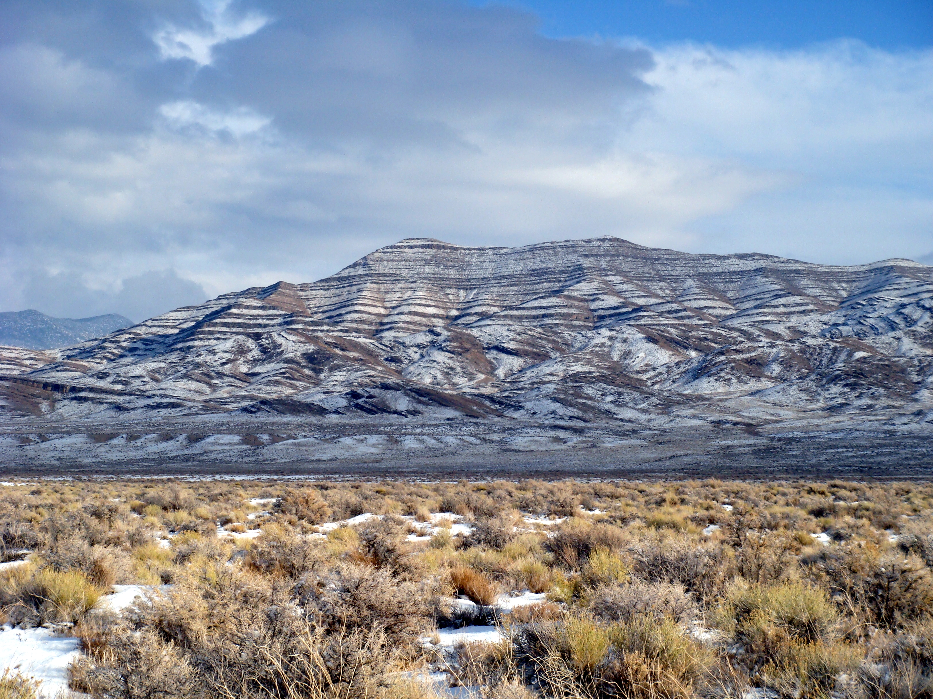
| photo | ConfusionR.JPG |
| photo_caption | The Confusion Range from Skull Rock Pass, looking west toward Kings Canyon (Utah) |
| photo_alt | A photo of the Confusion Range viewed from Skull Rock Pass |
| country | United States |
| state | Utah |
| area_mi2 | 1323 |
| length_mi | 78 |
| length_orientation | N/S |
| width_mi | 31 |
| width_orientation | E/W |
| highest | King Top |
| elevation_ft | 8350 |
| coordinates |
The Confusion Range is a north-south trending mountain range in west-central Utah, United States. It is bounded by Snake Valley to the west, Tule Valley to the east, the Great Salt Lake Desert to the north, and the Ferguson Desert to the south. The range trends into the Burbank Hills, Mountain Home Range, and the Wah Wah Mountains to the south. In the central part of the range, an offshoot of the mountains to the west is known as the Conger Range. The Confusion Range is named for its "rugged isolation and confusing topography."
The highest peaks in the range are Conger Mountain , which is 7,713 feet tall, and King Top , which is 8,350 feet tall.
Geology
The geology of the Confusion range is deformed Silurian to Permian limestones, dolomites, and shales.
Roads
There are three main ways to travel through the Confusion Range:
- Around the north end, from Callao, Utah to Sand Pass
- On old Highway 6/50, on a dirt road through Cowboy Pass
- On US Highway 6/US Highway 50, through Kings Canyon (Utah)
References
References
- Van Cott, J. W., 1990, Utah Place Names, {{ISBN. 0-87480-345-4
- {{cite peakbagger. 133450. Confusion Range. January 13, 2013
- "Mountains in USA".
- {{cite peakbagger. 17162. King Top, Utah. January 13, 2013
- Chronic, Halka, 1990, Roadside Geology of Utah, {{ISBN. 0-87842-228-5
This article was imported from Wikipedia and is available under the Creative Commons Attribution-ShareAlike 4.0 License. Content has been adapted to SurfDoc format. Original contributors can be found on the article history page.
Ask Mako anything about Confusion Range — get instant answers, deeper analysis, and related topics.
Research with MakoFree with your Surf account
Create a free account to save articles, ask Mako questions, and organize your research.
Sign up freeThis content may have been generated or modified by AI. CloudSurf Software LLC is not responsible for the accuracy, completeness, or reliability of AI-generated content. Always verify important information from primary sources.
Report