From Surf Wiki (app.surf) — the open knowledge base
Columbiana County, Ohio
County in Ohio, United States

County in Ohio, United States
| Field | Value |
|---|---|
| county | Columbiana County |
| state | Ohio |
| flag | Columbiana County Flag.png |
| seal | Seal of Columbiana County (Ohio).svg |
| founded | May 1, 1803 |
| seat wl | Lisbon |
| largest city wl | Salem |
| area_total_sq_mi | 535 |
| area_land_sq_mi | 532 |
| area_water_sq_mi | 2.8 |
| area percentage | 0.5% |
| census yr | 2020 |
| pop | 101877 |
| density_sq_mi | 190 |
| time zone | Eastern |
| web | www.columbianacounty.org |
| named for | Christopher Columbus |
| ex image | Columbiana County, Ohio Courthouse August 2022.jpg |
| ex image size | 250 |
| ex image cap | Columbiana County Courthouse |
| district | 6th |
Columbiana County is located in the U.S. state of Ohio. As of the 2020 census, the population was 101,877. The county seat is Lisbon and its largest city is Salem. Created in 1803, the county name is derived from that of 15th-century Italian explorer Christopher Columbus.
Columbiana County is predominantly rural and considered part of Appalachian Ohio. While northern communities are more associated with Northeast Ohio, southern communities along the Ohio River are culturally closer to the Upper Ohio Valley region. Columbiana County comprises the Salem, Ohio micropolitan statistical area, which is also included in the larger Youngstown–Warren–Salem combined statistical area. Officially considered part of the Youngstown media market, stations from Steubenville regularly report in the area as well.
History
The principal historic Native American peoples in the area were the Lenape, Mingo, and Wyandot. The Wyandot had an encampment where the city of Salem now stands. Several important indigenous trails ran through the county, the most important being the Great Trail which ran through the southern parts of the county towards Sandusky. Throughout the second half of the 18th century, starting with Christopher Gist in 1750, American colonists explored the area as the Ohio Company surveyed. George Washington, while engaged in land examinations, camped in the area of present-day East Liverpool in October 1770.
In the 1780s, the Native Americans relinquished control of the area, and the region was surveyed in accordance with the Land Ordinance of 1785. The ensuing Public Land Survey System of the United States started by surveyor Thomas Hutchins on north bank of the Ohio River in present-day East Liverpool resulted in the Seven Ranges, believed to be "the first mathematically designed system and nationally conducted cadastral survey in any modern country."
The first permanent settlement in the area was in 1792 or 1793, by hunter John Quinn, who settled in St. Clair Township near present-day Calcutta. Columbiana County was founded in 1803 and named in honor of Christopher Columbus, combining his surname with the suffix -iana. It was settled early on by Quakers and Scotch-Irish from Pennsylvania, but was later settled primary by Germans. The county was the scene of one of the northernmost action fought during the American Civil War; on July 26, 1863, Confederate raiders under John Hunt Morgan were surrounded and captured by Union Army forces at the Battle of Salineville.
The county was home to the largest pottery industry in the world, in East Liverpool and surrounding communities, which produced more than half of the United States' annual ceramics output. Throughout East Liverpool's ceramics history, there were more than 300 potteries. Other chief industries included iron and brick making, as well as transportation via the Ohio River, Sandy and Beaver Canal, and Pennsylvania Railroad system.
The East Palestine, Ohio, train derailment occurred on February 3, 2023. A freight train containing hazardous materials including vinyl chloride derailed in East Palestine. After burning for more than two days, emergency crews conducted a controlled burn of the train's contents, releasing toxic hydrogen chloride and phosgene into the air, and contaminating the Ohio River.
Geography
According to the U.S. Census Bureau, the county has a total area of 535 sqmi, of which 532 sqmi is land and 2.8 sqmi (0.5%) is water.
The Little Beaver Creek watershed is home to Beaver Creek State Forest, Beaver Creek State Park, and Sheepskin Hollow State Nature Preserve. Yellow Creek State Forest is in the southern part of the county.
Adjacent counties
- Mahoning County (north)
- Lawrence County, Pennsylvania (northeast)
- Beaver County, Pennsylvania (east)
- Hancock County, West Virginia (southeast)
- Jefferson County (south)
- Carroll County (southwest)
- Stark County (west)
Major highways
Demographics
|align-fn=center 1790–1960 1900–1990 1990–2000 2020
2020 census
As of the 2020 census, the county had a population of 101,877. The median age was 45.1 years. 20.2% of residents were under the age of 18 and 21.5% of residents were 65 years of age or older. For every 100 females there were 101.8 males, and for every 100 females age 18 and over there were 101.1 males age 18 and over.
The racial makeup of the county was 92.4% White, 2.1% Black or African American, 0.3% American Indian and Alaska Native, 0.3% Asian,
44.5% of residents lived in urban areas, while 55.5% lived in rural areas.
There were 41,706 households in the county, of which 26.0% had children under the age of 18 living in them. Of all households, 47.2% were married-couple households, 19.2% were households with a male householder and no spouse or partner present, and 26.1% were households with a female householder and no spouse or partner present. About 30.2% of all households were made up of individuals and 14.2% had someone living alone who was 65 years of age or older.
There were 46,091 housing units, of which 9.5% were vacant. Among occupied housing units, 72.8% were owner-occupied and 27.2% were renter-occupied. The homeowner vacancy rate was 1.7% and the rental vacancy rate was 8.6%.
Racial and ethnic composition
| Race / Ethnicity (NH = Non-Hispanic) | title=1980 Census of Population - General Social and Economic Characteristics - Ohio- Table 59 - Persons by Spanish Origin, Race, and Sex: 1980 AND Table 58 - Race by Sex: 1980 | url=https://www2.census.gov/library/publications/decennial/1980/volume-1/ohio/1980censusofpopu80137un_bw.pdf | website=United States Census Bureau | page=49-67 and 27-47}} | Pop 1990 | title=P004: Hispanic or Latino, and Not Hispanic or Latino by Race – 2000: DEC Summary File 1 – Columbiana County, Ohio | url=https://data.census.gov/table?g=050XX00US39029&tid=DECENNIALSF12000.P004 | website=United States Census Bureau | access-date= }} | title=P2: Hispanic or Latino, and Not Hispanic or Latino by Race – 2010: DEC Redistricting Data (PL 94-171) – Columbiana County, Ohio | url=https://data.census.gov/cedsci/table?q=p2&g=050XX00US39029&tid=DECENNIALPL2010.P2 | website=United States Census Bureau | access-date= }} | Pop 2020 | % 1980 | % 1990 | % 2000 | % 2010 | % 2020 |
|---|---|---|---|---|---|---|---|---|---|---|---|---|---|---|---|---|---|---|---|
| White alone (NH) | 111,322 | 106,057 | 107,045 | 102,326 | 93,466 | 98.02% | 97.95% | 95.51% | 94.89% | 91.74% | |||||||||
| Black or African American alone (NH) | 1,400 | 1,406 | 2,423 | 2,323 | 2,082 | 1.23% | 1.30% | 2.16% | 2.15% | 2.04% | |||||||||
| Native American or Alaska Native alone (NH) | 132 | 165 | 178 | 164 | 161 | 0.12% | 0.15% | 0.16% | 0.15% | 0.16% | |||||||||
| Asian alone (NH) | 200 | 215 | 248 | 319 | 345 | 0.18% | 0.20% | 0.22% | 0.30% | 0.34% | |||||||||
| Native Hawaiian or Pacific Islander alone (NH) | x | x | 17 | 20 | 16 | x | x | 0.02% | 0.02% | 0.02% | |||||||||
| Other race alone (NH) | 105 | 28 | 45 | 55 | 217 | 0.09% | 0.03% | 0.04% | 0.05% | 0.21% | |||||||||
| Mixed race or Multiracial (NH) | x | x | 810 | 1,286 | 3,838 | x | x | 0.72% | 1.19% | 3.77% | |||||||||
| Hispanic or Latino (any race) | 413 | 405 | 1,309 | 1,348 | 1,752 | 0.36% | 0.37% | 1.17% | 1.25% | 1.72% | |||||||||
| Total | 113,572 | 108,276 | 112,075 | 107,841 | 101,877 | 100.00% | 100.00% | 100.00% | 100.00% | 100.00% |
2010 census
As of the 2010 United States census, there were 107,841 people, 42,683 households, and 29,101 families residing in the county.{{cite web
Of the 42,683 households, 29.8% had children under the age of 18 living with them, 51.4% were married couples living together, 11.5% had a female householder with no husband present, 31.8% were non-families, and 26.8% of all households were made up of individuals. The average household size was 2.43 and the average family size was 2.92. The median age was 42.3 years.
The median income for a household in the county was $39,502 and the median income for a family was $48,948. Males had a median income of $39,614 versus $27,179 for females. The per capita income for the county was $19,635. About 12.1% of families and 16.0% of the population were below the poverty line, including 25.6% of those under age 18 and 6.4% of those age 65 or over.
2000 census
As of the census of 2000, there were 112,075 people, 42,973 households, and 30,682 families residing in the county. The population density was 210 /mi2. There were 46,083 housing units at an average density of 86 /mi2. The racial makeup of the county was 96.43% White, 2.20% Black or African American, 0.18% Native American, 0.23% Asian, 0.02% Pacific Islander, 0.15% from other races, and 0.79% from two or more races. 1.17% of the population were Hispanic or Latino of any race. 24.0% were of German, 12.9% English, 12.8% American, 12.3% Irish and 9.3% Italian ancestry according to Census 2000.
There were 42,973 households, out of which 31.70% had children under the age of 18 living with them, 57.10% were married couples living together, 10.30% had a female householder with no husband present, and 28.60% were non-families. 24.80% of all households were made up of individuals, and 11.90% had someone living alone who was 65 years of age or older. The average household size was 2.52 and the average family size was 3.00.
In the county, the population was spread out, with 24.30% under the age of 18, 7.80% from 18 to 24, 28.60% from 25 to 44, 24.20% from 45 to 64, and 15.00% who were 65 years of age or older. The median age was 38 years. For every 100 females there were 98.80 males. For every 100 females age 18 and over, there were 96.60 males.
The median income for a household in the county was $34,226, and the median income for a family was $40,486. Males had a median income of $32,134 versus $20,331 for females. The per capita income for the county was $16,655. About 9.00% of families and 11.50% of the population were below the poverty line, including 16.20% of those under age 18 and 8.40% of those age 65 or over.
Politics
Unlike most counties in Northeast Ohio, Columbiana County has been predominantly Republican throughout most of its history. In only eight elections from 1856 to the present has a Democratic Party candidate won the county, the most recent being Bill Clinton in 1996. Despite this, the county was a swing county in the latter half of the 20th century, voting for the national winner in all but two elections from 1952 to 2004. However, it has trended heavily Republican in more recent elections, with the party's candidates garnering increasing amounts of the vote in each presidential election from 2000 on. This trend was most apparent in 2016 when Donald Trump posted the best showing by a Republican in the county since Herbert Hoover in 1928 with a 41.4-point margin of victory over Hillary Clinton. |}
Government
County officials
| Party | Name | Position | |
|---|---|---|---|
| Republican Party (United States)}}" | R | Mike Halleck | |
| Republican Party (United States)}}" | R | Roy Paparodis | |
| Republican Party (United States)}}" | R | Tim Weigle | |
| Republican Party (United States)}}" | R | Nancy Gause Milliken | |
| Republican Party (United States)}}" | R | Anthony J. Dattilio | |
| Republican Party (United States)}}" | R | George Scott Wilson | |
| Republican Party (United States)}}" | R | Bert Dawson | |
| Republican Party (United States)}}" | R | Vito J. Abruzzino | |
| Republican Party (United States)}}" | R | James Armeni, Sr. | |
| Republican Party (United States)}}" | R | Brian McLaughlin | |
| Republican Party (United States)}}" | R | Bryan Blakeman |
Judicial representation
| Party | Name | Position | |
|---|---|---|---|
| Republican Party (United States)}}" | R | Megan L. Bickerton | |
| Republican Party (United States)}}" | R | Scott A. Washam | |
| Republican Party (United States)}}" | R | Thomas M. Baronzzi | |
| Republican Party (United States)}}" | R | Kelly Linger | |
| Republican Party (United States)}}" | R | Timothy J. McNicol | |
| Democratic Party (United States)}}" | D | Cheryl L. Waite | |
| Republican Party (United States)}}" | R | Carol Ann Robb | |
| Republican Party (United States)}}" | R | Katelyn D. Dickey | |
| Republican Party (United States)}}" | R | Mark A. Hanni |
Legislative representation
| Party | Name | District | Body | |
|---|---|---|---|---|
| Republican Party (United States)}}" | R | Monica Robb Blasdel | 79 | |
| Republican Party (United States)}}" | R | Alessandro Cutrona | 33 | |
| Republican Party (United States)}}" | R | Michael Rulli | 6 | |
| Republican Party (United States)}}" | R | Bernie Moreno | Statewide | |
| Republican Party (United States)}}" | R | Jon Husted | Statewide |
Education
Colleges and universities
- Allegheny Wesleyan College
- Kent State University at East Liverpool
- Kent State University at Salem
Community, junior, and technical colleges
- Columbiana County Career and Technical Center
- East Ohio College
- New Castle School of Trades
Public school districts
- Beaver Local School District
- Columbiana Exempted Village School District
- Crestview Local School District
- East Liverpool City School District
- East Palestine City School District
- Leetonia Exempted Village School District
- Lisbon Exempted Village School District
- Minerva Local School District
- Salem City School District
- Southern Local School District
- United Local School District
- Wellsville Local School District
- West Branch Local School District
High schools
- Beaver Local High School
- Columbiana High School
- Crestview High School
- David Anderson Junior/Senior High School
- East Liverpool Junior/Senior High School
- East Palestine High School
- Leetonia High School
- Salem High School
- Southern Local Junior/Senior High School
- United High School
- Wellsville Junior/Senior High School
Private schools
- Heartland Christian School – Columbiana
- East Liverpool Christian School – Glenmoor
- St. Paul Elementary School – Salem
Communities
Cities
- Columbiana
- East Liverpool
- Salem
Villages
- East Palestine
- Hanoverton
- Leetonia
- Lisbon (county seat)
- Minerva
- New Waterford
- Rogers
- Salineville
- Summitville
- Washingtonville
- Wellsville
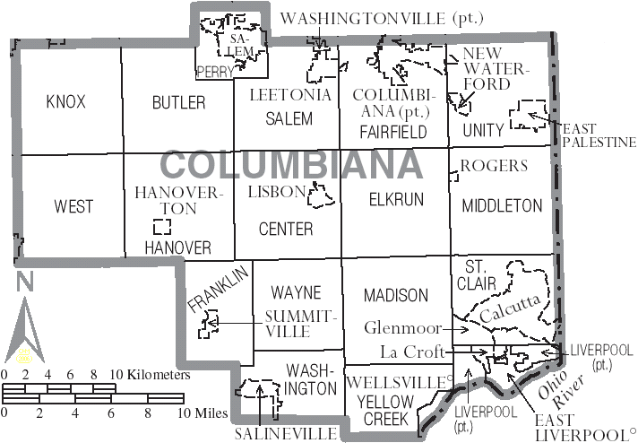
Townships
- Butler
- Center
- Elkrun
- Fairfield
- Franklin
- Hanover
- Knox
- Liverpool
- Madison
- Middleton
- Perry
- Salem
- St. Clair
- Unity
- Washington
- Wayne
- West
- Yellow Creek
Census-designated places
- Calcutta
- Damascus
- East Rochester
- Glenmoor
- Homeworth
- La Croft
- Lake Tomahawk
- Negley
- Salem Heights
Unincorporated communities
- Achor
- Bayard
- Cannons Mill
- Chambersburg
- Clarkson
- Dungannon
- East Carmel
- East Fairfield
- Elkton
- Franklin Square
- Fredericktown
- Gavers
- Glasgow
- Guilford
- Highlandtown
- Kensington
- Lynchburg
- Middleton
- Mill Rock
- Millport
- Moultrie
- New Alexander
- New Garden
- New Middleton
- New Salisbury
- North Georgetown
- Reading
- Signal
- Teegarden
- Unionville
- Unity
- Valley
- West Point
- Williamsport
- Winona
Population ranking
The population ranking of the following table is based on the 2020 census of Columbiana County.
***** majority of municipality in Columbiana County
****** minority of municipality in Columbiana County
† county seat
| Rank | City/Town/etc. | Population (2020 Census) | Township | Municipal type |
|---|---|---|---|---|
| 1 | Salem* | 11,915 | Perry, Salem | City |
| 2 | East Liverpool | 9,958 | Liverpool | City |
| 3 | Columbiana* | 6,559 | Fairfield, Unity | City |
| 4 | East Palestine | 4,761 | Unity | Village |
| 5 | Calcutta | 3,941 | St. Clair | CDP |
| 6 | Minerva** | 3,684 | West | Village |
| 7 | Wellsville | 3,113 | Yellow Creek | Village |
| 8 | † Lisbon | 2,597 | Center, Elkrun | Village |
| 9 | Leetonia | 1,833 | Salem, Fairfield | Village |
| 10 | Glenmoor | 1,829 | St. Clair | CDP |
| 11 | Salineville | 1,206 | Washington | Village |
| 12 | New Waterford | 1,194 | Unity | Village |
| 13 | La Croft | 1,078 | Liverpool | CDP |
| 14 | Washingtonville* | 712 | Salem | Village |
| 15 | Lake Tomahawk | 494 | Middleton | CDP |
| 16 | Homeworth | 492 | Knox | CDP |
| 17 | Damascus** | 418 | Butler | CDP |
| 18 | Hanoverton | 354 | Hanover | Village |
| 19 | Negley | 274 | Middleton | CDP |
| 20 | East Rochester | 224 | West | CDP |
| 21 | Rogers | 194 | Middleton | Village |
| 22 | Summitville | 110 | Franklin | Village |
Notable residents
- Harvey Firestone, businessman and founder of the Firestone Tire and Rubber Company
- William M. Fogo, Wisconsin legislator and newspaper editor
- Mark Hanna, U.S. senator from Ohio; grew up in Lisbon
- Ammon Hennacy, Christian anarchist; grew up in Negley
- Lou Holtz, former college football coach; grew up in East Liverpool
- Robert Justice, early Ohio statesman
- Rich Karlis, former NFL placekicker for the Denver Broncos, Minnesota Vikings and Detroit Lions, from Salem, Ohio
- William McKinley, 25th president of the United States; grew up in Lisbon
- William Ralston, who founded the Bank of California and became for a time the richest man in California; born in Columbiana County
- Clement Vallandigham, Copperhead leader; born and lived for several years in Lisbon
- Derek Wolfe, former NFL defensive end for the Denver Broncos and Baltimore Ravens; grew up in Negley
References
References
- "Ohio County Profiles: Columbiana County". Ohio Department of Development.
- [https://www.census.gov/library/visualizations/interactive/2020-population-and-housing-state-data.html 2020 census]
- "Find a County". National Association of Counties.
- "Columbiana County data". [[Ohio State University]] Extension Data Center.
- "Appalachian Counties Served by the ARC". Appalachian Regional Commission.
- "Historical Sketch of Columbiana County". Columbiana County Courts website.
- Joseph S. Mendinghall. (December 27, 1974). ["National Register of Historic Places Inventory-Nomination: Beginning Point / Beginning Point of the U.S. Public Land Survey"]({{NHLS url). National Park Service.
- [http://www.themuseumofceramics.org/ Museum of Ceramics]
- "The City of East Liverpool".
- (February 11, 2023). "Ohio catastrophe is 'wake-up call' to dangers of deadly train derailments".
- (August 22, 2012). "2010 Census Gazetteer Files". United States Census Bureau.
- [http://www.dnr.ohio.gov/forestry/forests/beavercreek.htm Beaver Creek State Forest] {{webarchive. link. (October 5, 2006)
- [http://www.dnr.ohio.gov/parks/parks/beaverck.htm Beaver Creek State Park] {{webarchive. link. (May 15, 2006)
- [http://www.dnr.ohio.gov/dnap/location/sheepskin.htm Sheepskin Hollow State Nature Preserve] {{webarchive. link. (October 7, 2006)
- (January 2014). "Yellow Creek State Forest and surrounding area". Ohio Department of Natural Resources Division of Forestry.
- "Population and Housing Unit Estimates".
- "U.S. Decennial Census". United States Census Bureau.
- "Historical Census Browser". University of Virginia Library.
- (March 27, 1995). "Population of Counties by Decennial Census: 1900 to 1990". United States Census Bureau.
- (April 2, 2001). "Census 2000 PHC-T-4. Ranking Tables for Counties: 1990 and 2000". United States Census Bureau.
- (2021). "2020 Decennial Census Demographic Profile (DP1)".
- (2021). "2020 Decennial Census Redistricting Data (Public Law 94-171)".
- (2023). "2020 Decennial Census Demographic and Housing Characteristics (DHC)".
- "1980 Census of Population - General Social and Economic Characteristics - Ohio- Table 59 - Persons by Spanish Origin, Race, and Sex: 1980 AND Table 58 - Race by Sex: 1980".
- "1990 Census of Population - General Population Characteristics - Ohio: Table 6 - Race and Hispanic Origin".
- "P004: Hispanic or Latino, and Not Hispanic or Latino by Race – 2000: DEC Summary File 1 – Columbiana County, Ohio".
- "P2: Hispanic or Latino, and Not Hispanic or Latino by Race – 2010: DEC Redistricting Data (PL 94-171) – Columbiana County, Ohio".
- "P2: Hispanic or Latino, and Not Hispanic or Latino by Race – 2020: DEC Redistricting Data (PL 94-171) – Columbiana County, Ohio".
- included in the Asian category in the 1980 Census
- included in the Asian category in the 1990 Census
- not an option in the 1980 Census
- not an option in the 1990 Census
- "Population, Housing Units, Area, and Density: 2010 - County". [[United States Census Bureau]].
- "DP02 SELECTED SOCIAL CHARACTERISTICS IN THE UNITED STATES – 2006-2010 American Community Survey 5-Year Estimates". [[United States Census Bureau]].
- "DP03 SELECTED ECONOMIC CHARACTERISTICS – 2006-2010 American Community Survey 5-Year Estimates". [[United States Census Bureau]].
- "U.S. Census website". [[United States Census Bureau]].
- Leip, David. "Dave Leip's Atlas of U.S. Presidential Elections".
- The leading "other" candidate, [[Progressive Party (United States, 1912). Progressive]] [[Theodore Roosevelt]], received 3,811 votes, while Socialist candidate [[Eugene V. Debs. Eugene Debs]] received 1,916 votes, [[Prohibition Party. Prohibition]] candidate [[Eugene W. Chafin. Eugene Chafin]] received 915 votes, and [[Socialist Labor Party of America. Socialist Labor]] candidate [[Arthur Reimer]] received 32 votes.
- (November 5, 2024). "2024 Senate Election (Official Returns)".
- "2020 U.S. Census website". [[United States Census Bureau]].
- "Harvey S. Firestone - Ohio History Central".
- "U.S. Senate: Mark Hanna and the 1896 Election".
- (July 15, 2011). "Biography: Lou Holtz".
- (1889). "Commemorative biographical record of the counties of Wayne and Holmes, Ohio, containing biographical sketches of prominent and representative citizens". Chicago : J. H. Beers.
This article was imported from Wikipedia and is available under the Creative Commons Attribution-ShareAlike 4.0 License. Content has been adapted to SurfDoc format. Original contributors can be found on the article history page.
Ask Mako anything about Columbiana County, Ohio — get instant answers, deeper analysis, and related topics.
Research with MakoFree with your Surf account
Create a free account to save articles, ask Mako questions, and organize your research.
Sign up freeThis content may have been generated or modified by AI. CloudSurf Software LLC is not responsible for the accuracy, completeness, or reliability of AI-generated content. Always verify important information from primary sources.
Report