From Surf Wiki (app.surf) — the open knowledge base
Coastline of the North Sea
Land bordering the North Sea
Land bordering the North Sea
The coastline of the North Sea has been evolving since the end of the last ice age. The coastline varies from fjords, river estuaries to mudflats.
The eastern and western coasts of the North Sea are jagged, as they were stripped by glaciers during the ice ages. The coastlines along the southernmost part are soft, covered with the remains of deposited glacial sediment, which was left directly by the ice or has been redeposited by the sea.{{cite encyclopedia
The Norwegian mountains plunge into the sea, giving rise, north of Stavanger, to deep fjords and archipelagos. South of Stavanger, the coast softens, the islands become fewer. The eastern Scottish coast is similar, though less severe than Norway. Starting from Flamborough Head in the north east of England, the cliffs become lower and are composed of less resistant moraine, which erodes more easily, so that the coasts have more rounded contours. In the Netherlands, Belgium and in the east of England (East Anglia) the littoral is low and marshy. The east coast and south-east of the North Sea (Wadden Sea) have coastlines that are mainly sandy and straight owing to longshore currents, particularly along Belgium and Denmark.{{cite book |chapter-url=https://books.google.com/books?id=9W7ofyqW5moC&q=%22longshore+currents%22+%22North+Sea%22&pg=PA134 |chapter-format=Digitized by Google Books online |access-date=2008-12-05 |book-title =in Herrier J.-L., J. Mees, A. Salman, J. Seys, H. Van Nieuwenhuyse, & I. Dobbelaere (Eds.) Proceedings ‘Dunes and Estuaries 2005’ – International Conference on Nature Restoration Practices in European Coastal Habitats |access-date =2008-11-02}}{{Cite web |access-date=2007-12-04 |url-status=dead |archive-url=https://web.archive.org/web/20070710023601/http://www.ospar.org/eng/doc/pdfs/R2C2.pdf |archive-date=2007-07-10
Northern fjords, skerries, and cliffs

The northern North Sea coasts bear the impression of the enormous glaciers which covered them during the Ice Ages and created fjords, lakes and valleys along the coastline and landscape. Fjords arose by the action of glaciers, which dragged their way through them from the highlands, cutting and scraping deep trenches in the land. Fjords are particularly common on the coast of Norway.{{cite book |access-date=2008-12-05
Firths are similar to fjords, but are generally shallower with broader bays in which small islands may be found.{{cite book |author-link=Philip George and son, ltd |access-date=2008-12-05 The glaciers that formed them influenced the land over a wider area and scraped away larger areas.{{cite book |access-date=2008-12-05 Firths are to be found on the Scottish coast.{{cite book |chapter-url=https://books.google.com/books?id=qLT1He2mdHIC&q=firths+%22North+Sea%22&pg=PA101 |chapter-format=Digitized by Google Books online |access-date=2008-12-05 Individual islands in the firths, or islands and the coast, are often joined up by sandbars or spits made up of sand deposits known as "tombolos".

Towards the south the firths give way to a cliff coast, which was formed by the moraines of Ice Age glaciers. The horizontal impact of waves on the North Sea coast gives rise to eroded coasts. The cliff landscape is interrupted in southern England by large estuaries with their corresponding fringing marshes, notably the Humber and the Thames.{{cite book |url-access=registration |access-date=2008-12-05 |access-date=2008-12-05
There are skerries in southern Norway formed by similar action to that which created the fjords and firths. The glaciers in these places affected the land to an even greater extent, so that large areas were scraped away. The coastal brim (Strandflaten), which is found especially in southern Norway, is a gently sloping lowland area between the sea and the mountains. It consists of plates of rock platforms, and often extends for kilometres, reaching under the sea, at a depth of only a few metres.{{cite book |chapter-url=https://books.google.com/books?id=q33WekTp7tgC&q=Norway+%22coastal+brim+%22&pg=PA210 |chapter-format=Digitized by Google Books online
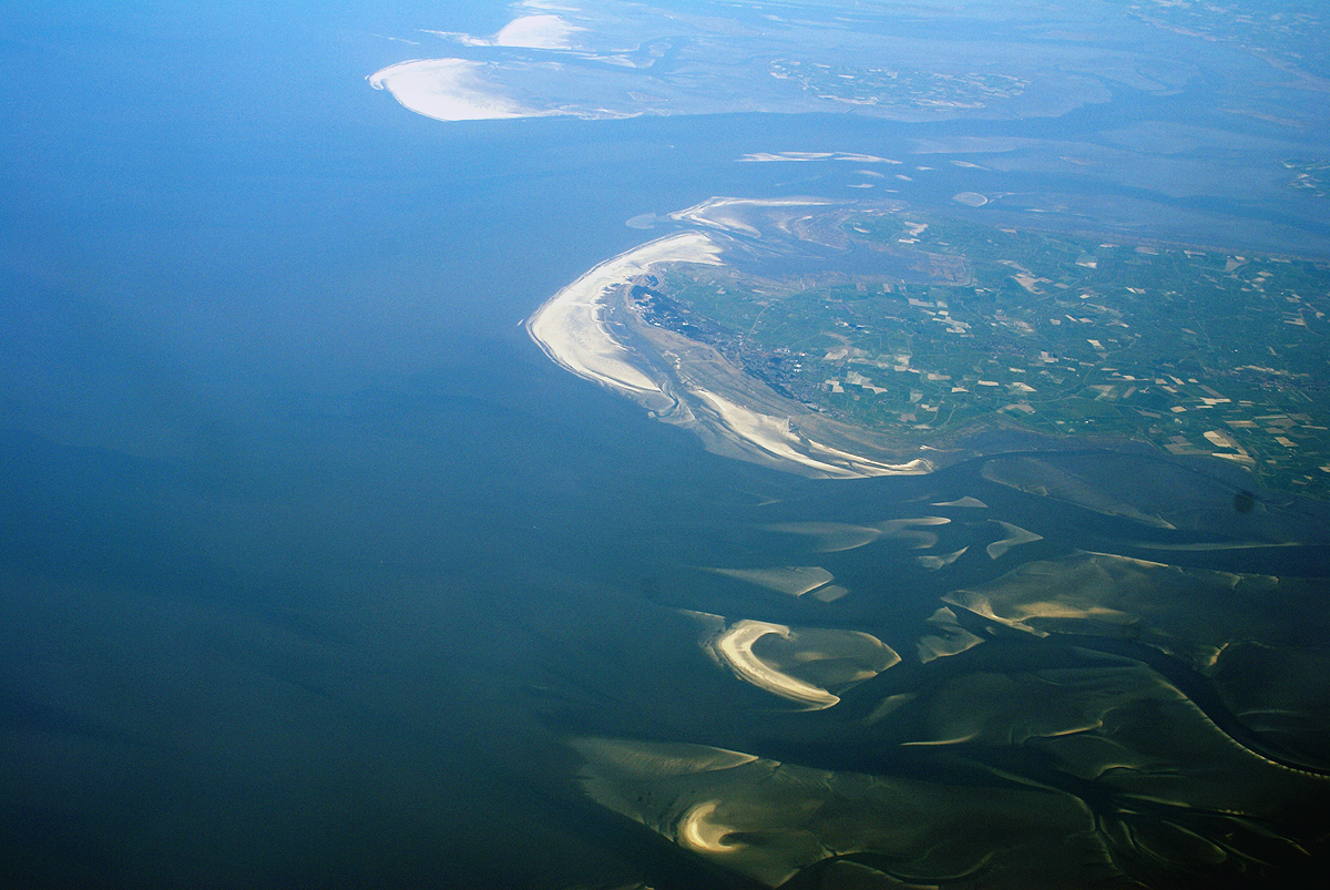
Southern shoals and mudflats
.jpg)
The shallow-water coasts of the southern and eastern coast up to Denmark were formed by ice age activity, but their particular shape is determined for the most part by the sea and sediment deposits.{{Cite web |access-date = 2007-07-24}}[[File:Tidal flats.jpg|thumb|left|upright|Mudflats in Germany]] The Wadden Sea stretches between Esbjerg, Denmark in the north and Den Helder, Netherlands in the west. This landscape is heavily influenced by the tides and important sections of it have been declared a National Park.{{cite book |chapter-url=https://books.google.com/books?id=LjXq6hwWU7wC&q=%22Wadden+Sea%22+%22national+park%22&pg=PA129 |chapter-format=Digitized by Google Books online |access-date=2008-12-08 The whole of the coastal zone is shallow; the tides flood large areas and uncover them again, constantly depositing sediments. The Southern Bight has been especially changed by land reclamation, as the Dutch have been especially active.{{Cite web |access-date =2008-12-04 |url-status =dead |archive-url =https://web.archive.org/web/20090816212926/http://www.coastalguide.to/netherlands/index.html |archive-date =2009-08-16 |access-date =2008-12-04 |url-status =dead |archive-url =https://web.archive.org/web/20080916041214/http://edc.usgs.gov/earthshots/slow/IJsselmeer/IJsselmeer |archive-date =2008-09-16
Tidal forces have formed the Frisian Islands. In the micro tidal area, (a tidal range of up to 1.35 m, such as on the Dutch or Danish coasts,{{cite web |access-date = 2008-11-02 |archive-url = https://web.archive.org/web/20081217143716/http://www.citg.tudelft.nl/live/binaries/4de0d195-5207-4e67-84bb-455c5403ae47/doc/2005Hollebrandse.pdf |archive-date = 2008-12-17 |url-status = dead barrier beaches with dunes are formed. In the mesotidal area (a tidal range of between 1.35 and), barrier islands are formed;{{cite book |access-date=2008-12-04 in the macrotidal area (above 2.9 m tidal range), intertidal deposits raise the spring tide range 4 m. A soft rock coast is formed in the meso-macro tidal areas located in the southern North Sea. These soft rock coastal bedrock plains are interspersed with soft rock (shale and sandstone) cliffs.{{cite web |access-date = 2008-12-04 |url-status = dead |archive-url = https://web.archive.org/web/20090107131519/http://www.eloisegroup.org/themes/habitats/typology1.htm |archive-date = 2009-01-07
The small, historically strategic island of Heligoland was not formed by recent sediment deposition; it is considerably older and is composed of early Triassic sandstone.
References
References
- International EMECS Center. (2003). "Environmental Guidebook 5: North Sea". International Center for the Environmental Management of Enclosed Coastal Seas (EMECS).
- May, V. J.. (2003). "Coastal Geomorphology of Great Britain". [[Joint Nature Conservation Committee]].
- Hansom, J. D.. "St Ninian's Tombolo". [[Joint Nature Conservation Committee]].
- "Development of the East Riding Coastline". East Riding of Yorkshire Council.
- "Holderness Coast United Kingdom". EUROSION Case Study.
This article was imported from Wikipedia and is available under the Creative Commons Attribution-ShareAlike 4.0 License. Content has been adapted to SurfDoc format. Original contributors can be found on the article history page.
Ask Mako anything about Coastline of the North Sea — get instant answers, deeper analysis, and related topics.
Research with MakoFree with your Surf account
Create a free account to save articles, ask Mako questions, and organize your research.
Sign up freeThis content may have been generated or modified by AI. CloudSurf Software LLC is not responsible for the accuracy, completeness, or reliability of AI-generated content. Always verify important information from primary sources.
Report