From Surf Wiki (app.surf) — the open knowledge base
Chugach Mountains
Mountains in southern Alaska, U.S.
Mountains in southern Alaska, U.S.
| Field | Value |
|---|---|
| name | Chugach Mountains |
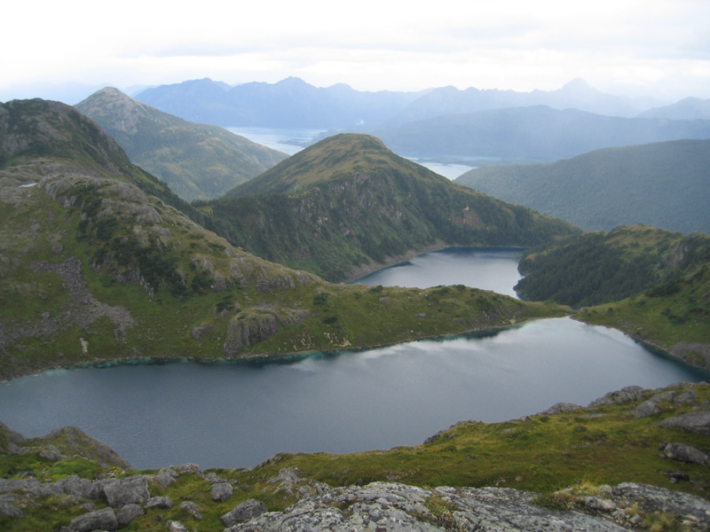
| photo | Chugach Panorama Alaska.jpg |
| photo_caption | View of the Chugach Mountains from the Glenn Highway, north of Anchorage |
| country | United States |
| state | Alaska |
| parent | Pacific Coast Ranges |
| length_mi | 300 |
| length_orientation | E–W |
| highest | Mount Marcus Baker |
| elevation_ft | 13094 |
| coordinates | |
| range_coordinates |

The Chugach Mountains of southern Alaska are the northernmost of the several mountain ranges that make up the Pacific Coast Ranges of the western edge of North America. The range is about 250 mi long and 60 mi wide, and extends from the Knik and Turnagain Arms of the Cook Inlet on the west to Bering Glacier, Tana Glacier, and the Tana River on the east. It is bounded on the north by the Matanuska, Copper, and Chitina rivers. The highest point of the Chugach Mountains is Mount Marcus Baker, at 13094 ft, but with an average elevation of 4006 ft, most of its summits are not especially high. Even so, its position along the Gulf of Alaska ensures more snowfall in the Chugach than anywhere else in the world, an annual average of over 1500 cm (800 in).
The mountains are protected in the Chugach State Park and the Chugach National Forest. Near to Anchorage, they are a popular destination for outdoor activities.
The Richardson Highway, Seward Highway, Portage Glacier Highway, and the Glenn Highway run through the Chugach Mountains. The Anton Anderson Memorial Tunnel of the Portage Glacier Highway provides railroad and automobile access underneath Maynard Mountain between Portage Lake and the city of Whittier on Prince William Sound.
On Mount Gordon Lyon, at about the 4,000 ft level, is a 300 ft five-pointed star using around 350 light globes. This faces Anchorage to be visible from the city at night. It is illuminated to commemorate Christmas, being lit from Thanksgiving until Christmas Day; and, on 9/11. Maintenance is undertaken by the US Air Force’s Joint Base Elmendorf-Richardson, although it was established in around 1960 and formerly maintained by the US Army having been near the former Army (Nike missile Site Summit) in the mountains.
History
The name "Chugach" comes from Chugach Sugpiaq Cuungaaciiq, Alaska Natives inhabiting the Kenai Peninsula and Prince William Sound on the south coast of Alaska. The Chugach people are an Alutiiq (Pacific Eskimo) people who speak the Chugach dialect of the Alutiiq language. In 1898 United States Army captain William R. Abercrombie spelled the name "Chugatch" and applied it to the mountains. It is possible that the Koniagmiut (Sugpiat or Alutiit of the Kodiak Archipelago and the Alaska Peninsula) may also have called these northern Sugpiat "Cuungaaciirmiut" in ancient times but it is also possible that this was a neologism during Russian times.
Mountains
The twelve highest peaks in the Chugach Mountains are listed below:
| Rank | Name | Elevation | Prominence | Coordinates |
|---|---|---|---|---|
| 1 | Mount Marcus Baker | 13176 ft | ||
| 2 | Mount Thor | 12251 ft | ||
| 3 | Mount Valhalla | 12135 ft | ||
| 4 | Mount Witherspoon | 11745 ft | ||
| 5 | Mount Einstein | 11401 ft | ||
| 6 | Mount Tom White | 11155 ft | ||
| 7 | Icing Peak | 10955 ft | ||
| 8 | Mount Grace | 10540 ft | ||
| 9 | Mount Goode | 10384 ft | ||
| 10 | Mount Steller | 10082 ft | ||
| 11 | Mount Gannett | 9629 ft | ||
| 12 | Mount Gilbert | 9101 ft |
Other important peaks in the Chugach Mountains include:
- Mount Michelson 8504 ft
- Bashful Peak 8005 ft
- Mount Billy Mitchell 6968 ft
- Mount Palmer 6703 ft
- Eagle Peak 6909 ft
- Polar Bear Peak 5656 ft
- Mount Williwaw 5445 ft
- The Ramp 5240 ft
- North Yuyanq’ Ch’ex 5065 ft
- Ptarmigan Peak 4839 ft
- Byron Peak 4590 ft
- Flattop Mountain 3245 ft
- Bold Peak 7522 ft
Gallery
File:Bold Peak.JPG|Bold Peak File:North Suicide Peak. Chugach Mountains, Alaska..jpg|North Yuyanq’ Ch’ex File:Peters Creek backtounry below Mount Rumble.JPG|Peters Creek backcountry, below Mount Rumble File:Mount Eklutna.jpg|Mount Eklutna File:Bashful Peak.jpg|Bashful Peak, the tallest mountain in western Chugach State Park File:ChugachMountainStream.jpg|Small stream in the Chugach Mountains File:Bold Peak. Chugach Mountains, Alaska.jpg|Bold Peak File:First view of Twin Peaks near Eklutna Lake (3200967294).jpg|Twin Peaks File:Mt. Rumble from the summit of Peak 5505. Chugach Mountains, Alaska - panoramio.jpg|Mount Rumble File:Goat Mountain. Chugach State Park, Alaska.jpg|Goat Mountain
References
References
- {{cite gnis
- Steep, Freeskiing Documentary, 2007
- [https://www.militarytimes.com/news/your-air-force/2021/12/02/airmen-help-save-holiday-tradition-in-alaskas-largest-city/ Airmen help save holiday tradition in Alaska’s largest city], [[The Associated Press]]/militarytimes.com, December 3, 2021
- {{cite gnis
- {{cite gnis
- {{cite gnis
- {{cite gnis
- {{cite gnis
- {{cite gnis
- (2012). "Icing Peak". peakbagger.com.
- (2012). "Mount Grace". peakbagger.com.
- {{cite gnis
- {{cite gnis
- {{cite gnis
- {{cite gnis
- {{cite gnis
- {{cite gnis
- {{cite gnis
- {{cite gnis
- {{cite gnis
- {{cite gnis
- {{cite gnis
- {{cite gnis
- {{cite gnis
This article was imported from Wikipedia and is available under the Creative Commons Attribution-ShareAlike 4.0 License. Content has been adapted to SurfDoc format. Original contributors can be found on the article history page.
Ask Mako anything about Chugach Mountains — get instant answers, deeper analysis, and related topics.
Research with MakoFree with your Surf account
Create a free account to save articles, ask Mako questions, and organize your research.
Sign up freeThis content may have been generated or modified by AI. CloudSurf Software LLC is not responsible for the accuracy, completeness, or reliability of AI-generated content. Always verify important information from primary sources.
Report