From Surf Wiki (app.surf) — the open knowledge base
Chittoor district
District of Andhra Pradesh, India

District of Andhra Pradesh, India
| Field | Value |
|---|---|
| name | Chittoor district |
| settlement_type | District of Andhra Pradesh |
| image_skyline | Galipgopuram of Kanipakam temple (May 2019) 8.jpg |
| image_caption | Galigopuram of Vinayaka Temple, Kanipakam |
| image_map | Chittoor in Andhra Pradesh (India).svg |
| mapframe | yes |
| mapframe-zoom | 7 |
| mapframe-wikidata | yes |
| map_caption | Location of Chittoor district in Andhra Pradesh |
| pushpin_label | |
| pushpin_label_position | right |
| coordinates | |
| coordinates_footnotes | tags -- |
| subdivision_type | Country |
| subdivision_name | |
| subdivision_type1 | State |
| subdivision_name1 | Emblem of Andhra Pradesh.svgAndhra Pradesh |
| subdivision_type2 | Region |
| subdivision_name2 | Rayalaseema |
| established_title | Formed |
| established_date | 1 April 1911 |
| seat_type | Headquarters |
| seat | Chittoor |
| parts_type | Largest City |
| parts | Chittoor |
| established_title1 | Reorganized |
| established_date1 | 4 April 2022 |
| leader_title | District collector |
| leader_name | Sumith kumar, IAS |
| leader_title1 | SP |
| leader_name1 | Tushar Dudi, IPS |
| leader_title2 | Lok Sabha |
| leader_name2 | {{Collapsible list |
| title | D Prasad Rao |
| frame_style | border:none; padding: 0; |
| list_style | text-align:left;display:none; |
| 1 | Chittoor |
| leader_title3 | Assembly |
| leader_name3 | {{Collapsible list |
| title | Gurajala Jagan Mohan |
| frame_style | border:none; padding: 0; |
| list_style | text-align:left;display:none; |
| 1 | Chittoor (SC) |
| 2 | Gangadhara Nellore (SC) |
| 3 | Kuppam |
| 4 | Nagari |
| 5 | Palamaner |
| 6 | Puthalapattu (SC) |
| unit_pref | Metric |
| area_footnotes | |
| area_total_km2 | 6,855 |
| area_urban_footnotes | |
| area_rural_footnotes | |
| elevation_footnotes | tags -- |
| elevation_point | |
| population_as_of | 2011 |
| population_footnotes | |
| population_total | 18,72,951 |
| population_urban_footnotes | |
| population_rural_footnotes | |
| population_blank1_title | Households |
| population_blank2_title | Sex ratio |
| population_blank2 | 985 (females per 1000 males) |
| population_demonym | |
| demographics_type1 | Languages |
| demographics1_title1 | Official |
| demographics1_info1 | Telugu |
| demographics1_title2 | Regional |
| demographics1_info2 | *Telugu - 73.23% |
| *Urdu - 8.72% <ref name | "language" |
| demographics2_footnotes | tags -- |
| demographics2_title1 | Literates |
| demographics3_footnotes | tags -- |
| timezone1 | IST |
| utc_offset1 | +5:30 |
| postal_code_type | Postal Index Number |
| postal_code | 517xxx |
| area_codes | +91–8572 |
| iso_code | IN-AP |
| registration_plate_type | Vehicle registration |
| registration_plate | AP-03 (former) AP–39 (from 30 January 2019) |
| blank_name_sec1 | GDP(2022-23) |
| blank_info_sec1 | |
| blank1_name_sec1 | Per capita income(2022–23) |
| blank1_info_sec1 | |
| website |
the district
| mapframe-zoom = 7 | mapframe-wikidata = yes
- Tamil- 16.75%
- Urdu - 8.72%
Chittoor district () is one of the eight districts in the Rayalaseema region of the Indian state of Andhra Pradesh. It had a population of 18,72,951 at the 2011 census of India. It is a major market centre for mangoes, grains, sugarcane, and peanuts. The district headquarters is at Chittoor City. The major cities/towns in the district are Chittoor, Punganur, Nagari, Palamaner, and Kuppam.
Etymology
The district derived its name from its headquarters Chittoor.
History
The modern Chittoor district was formerly North Arcot District, which was established by the British in the 19th century. It had Chittoor as its headquarters. Chittoor district was constituted on 1 April 1911 with the taluks of Chittoor, Palamaner, and Chandragiri from Old North Arcot district of Tamilnadu, Madanapalle and Voyalpadu Taluks of Kadapa district and Ex-Zamindari areas of Pileru, Punganur, Srikalahasthi, Puttur and Old Karvetinagar estate.
After the Indian independence in 1947, Chittoor region became a part of the erstwhile Madras state. As a result of Pataskar Award consequent on the re-organisation of the state on a linguistic basis on 1 April 1960, a major portion of Tiruthani taluk was transferred to Chengalpattu district of Tamilnadu in exchange for one taluk known as Sathyavedu comprising 186 villages from Tamilnadu. Also from the same date, 220 villages from Palamaner Taluk and three villages from Krishnagiri Taluk of Salem District of Tamilnadu were transferred to form Kuppam Sub-Taluk and 145 villages from Chittoor Taluk were transferred to form Bangarupalem Sub-Taluk. Subsequently, Kuppam and Bangarupalem were made full-fledged taluks. The district was organised into 66 revenue mandals in 1985. Again the District Re-organised with 31 Mandals and 4 Revenue Divisions on 4 April 2022.
Annamayya district and Tirupati district were formed from parts of the erstwhile Chittoor district and others. This has resulted in the district becoming primarily rural and losing central educational institutes and health infrastructure.
Demographics
According to the 2011 census, Chittoor district prior to restructuring in 2022 had a population of 4,174,064.{{cite web | author = US Directorate of Intelligence | title = Country Comparison:Population | url = https://www.cia.gov/library/publications/the-world-factbook/rankorder/2119rank.html | archive-url = https://web.archive.org/web/20070613004507/https://www.cia.gov/library/publications/the-world-factbook/rankorder/2119rank.html | url-status = dead | archive-date = 13 June 2007 | access-date = 1 October 2011 | quote =Lebanon 4,143,101 July 2011 est. |access-date=30 September 2011 |url-status=dead |archive-url=https://web.archive.org/web/20131019160532/http://2010.census.gov/2010census/data/apportionment-pop-text.php |archive-date=19 October 2013
Economy
The Gross District Domestic Product (GDDP) of the undivided district for FY 2013-14 is and it contributes 6.6% to the Gross State Domestic Product (GSDP). For the FY 2013–14, the per capita income at current prices was . The primary, secondary and tertiary sectors of the district contribute , and respectively. The major products contributing to the GVA of the district from agriculture and allied services are, sugarcane, groundnut, tomato, mango, milk, meat and fisheries. The GVA to the industrial and service sector is contributed from construction, electricity, manufacturing, education and ownership of dwellings.
Hydrology and climate
The important rivers in the district before restructuring were Ponnai and Swarnamukhi, which originate in the Eastern Ghats. Other rivers include Araniyar, Bahuda, Beema, Cheyyeru, Kalangi, Kalyani, Koundinya, Kusasthali, Neeva, Papaghni, Pileru, Pincha, and Pedderu. None of the rivers are perennial.
The temperature in the western parts of the undivided district like Pileru, Punganur, Madanapalle, Horsley Hills are relatively lower than the eastern parts of the Chittoor District. This is because of the higher altitude of the western parts compared to the eastern parts. The summer temperature touches 44 °C in the eastern parts whereas in the western parts, it ranges around 36 ° to 38 °C. Similarly, the winter temperatures of the western parts are relatively low ranging from 12 °C to 14 °C, and in eastern parts it is 16 °C to 18 °C. Most of the district has a Tropical wet and dry climate, with some north-western parts having Hot semi-arid climate.
Undivided Chittoor district receives an annual rainfall of 918.1 mm. The South West Monsoon and North East Monsoon are the major sources of rainfall for the district. On average the district receives 438.0 mm of rainfall through the South West Monsoon (From June to September) and 396.0 mm from North East Monsoon (From October to December). The rainfall received by the district in the years 2002 and 2003 were 984.2 mm and 934 mm respectively.
Geography
Chittoor is a part of Rayalaseema region of Andhra Pradesh. The district occupies an area of 6855 km2. This district is also under Tondai Nadu Region. The district is bounded by Annamayya district to the North, Krishnagiri District, Tirupattur District, Vellore District and Tiruvallur District of Tamil Nadu state to the South, Tirupati district to the East & North, Kolar District of Karnataka state to the West.
The district is located between the northern latitudes of 12°-44’-42″ and 13°-39’-21″ and between the eastern longitudes 78°-2’-2″ and 79°-41’-52″. Chittoor, the district headquarters is 150 km from Chennai, 165 km from Bangalore.
Climate
Chitoor has been ranked 21st best “National Clean Air City” under (Category 3 population under 3 lakhs cities) in India.
Demographics
After reorganisation, the district had a population of 18,72,951, of which 368,644 (19.68%) lived in urban areas. Chittoor district has a sex ratio of 993 females per 1000 males. Scheduled Castes and Scheduled Tribes made up 3,94,327 (21.05%) and 51,574 (2.75%) of the population respectively.
Based on the 2011 census, 73.23% of the population spoke Telugu, 16.75% Tamil and 8.72% Urdu as their first language. Telugu is the primary official language of the district along with English. Tamil is widely spoken in the border areas, especially in Kuppam.
Administrative divisions
The district is divided into four revenue divisions: Chittoor, Kuppam, Nagari and Palamaner, which are further subdivided into a total of 28 mandals, each headed by a sub-collector.
Mandals
The list of 28 mandals in Chittoor district, is given below.
- Chittoor revenue division
- Bangarupalyam
- Chittoor Rural
- Chittoor Urban
- Gangadhara Nellore
- Gudipala
- Irala
- Penumuru
- Pulicherla
- Puthalapattu
- Rompicherla
- Srirangarajapuram
- Thavanampalle
- Vedurukuppam
- Yadamari
- Kuppam revenue division
- Gudupalle
- Kuppam
- Ramakuppam
- Santhipuram
- Nagari revenue division
- Karvetinagar
- Nagari
- Nindra
- Palasamudram
- Vijayapuram
- Palamaner revenue division
- Baireddipalle
- Palamaner
- Gangavaram
- Peddapanjani
- Venkatagirikota
Cities and towns
Chittoor is a Municipal Corporation, while Kuppam, Palamaner and Nagari are municipalities.
| Ciy/Town | Civil status | Revenue Division | 19,21,58}} |
|---|---|---|---|
| Chittoor | Municipal Corporation | Chittoor | 175,647 |
| Nagari | Municipality Grade 3 | Nagari | 62,253 |
| Palamaner | Municipality Grade 3 | Palamaner | 54,035 |
| Kuppam | Municipality Grade 3 | Kuppam | 39,000 |
Villages
- Bandarlapalle
- Govindareddipalle
- Kaliambakam
- Marrimakula Kandriga
- Panatoor
- Yerrathivaripalli
Politics
There are two parliamentary and seven assembly constituencies located in this district. The parliamentary constituencies are Chittoor (Lok Sabha constituency) and Rajampet Lok Sabha constituency(partial). The assembly constituencies are given below.
| Constituency number | Assembly constituency | Reserved for | |
|---|---|---|---|
| (SC/ST/None) | Parliamentary constituency | ||
| 165 | Punganur (partial) | None | Rajampet |
| 170 | Nagari | None | Chittoor |
| 171 | Gangadhara Nellore | SC | |
| 172 | Chittoor | None | |
| 173 | Puthalapattu | SC | |
| 174 | Palamaner | None | |
| 175 | Kuppam | None |
Economy

Agriculture and horticulture are the mainstays of the district's economy.
Transport
Roadways
NH 69 and NH 40 pass through the district. Six lane expressway connecting Tirupati and Bangalore via Chittoor is operational. NH 42, a two lane Highway from Anantapur-Kuppam-Krishnagiri passes through the District.
Railways
Chittoor District has two major railway stations.
- Chittoor railway station on the Gudur-Katpadi line
- Kuppam railway station on the Bangalore–Chennai main line
Airports
Nearest airports
Tirupati Airport at a distance of 86Km from Chittoor
Kuppam Airport at a distance of 120Km from Chittoor
Education
Dravidian University is the only university in the district after the reorganisation.
Notable sites
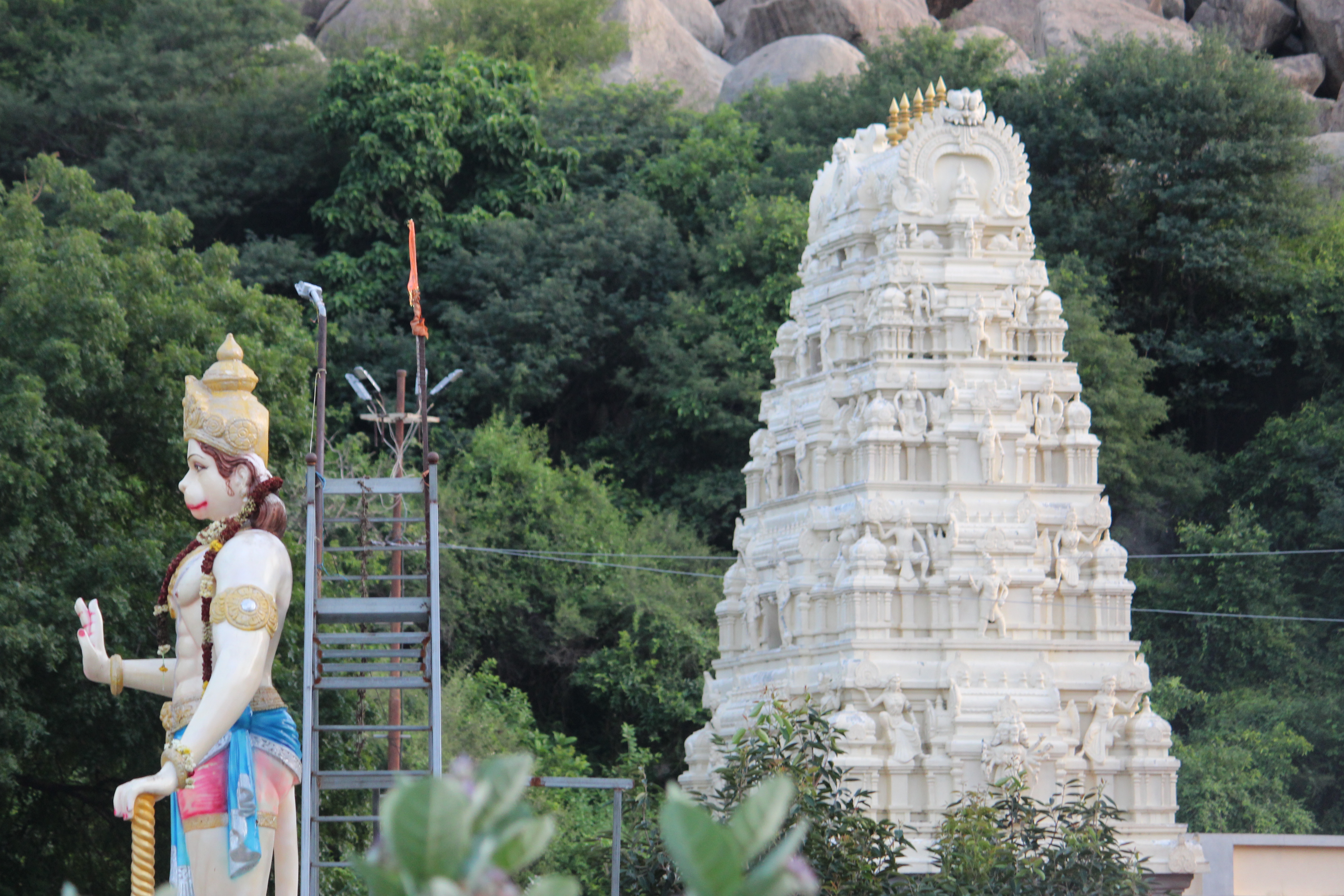
.JPG)
- Vinayaka Temple, Kanipakam: at a distance of 11Km from Chittoor, 11th century temple dedicated to Lord Ganesh in Kanipakam.
- Kaigal Water Falls: at a distance of 28 km from Palamaner, water falls from a height of 40 feet in all seasons
- Koundinya Wildlife Sanctuary: located at a distance of 50 km from Chittoor, spread over 358 SqKm, elephant, cheetah, four horned antelope and other wildlife can be seen here.
- Veeranjaneya Temple, Ardhagiri: at a distance of 27 km from Chittoor, this place is related to the mythological story of Lord Hanuman, as the place where the half of the Sanjeevani mountain that he was carrying fell.
Notable people
V. Nagayya, also known as Chittoor Nagayya, was brought up in Kuppam. He was a pioneering Indian actor, singer, music composer, and director in the Telugu and Tamil film industry.
Cattamanchi Ramalinga Reddy was born in Kattamanchi, a suburb of Chittoor. He was an educationist, economist, poet and literary critic.
Prathap Chandra Reddy, born in Aragonda, is a cardiologist who founded the first corporate chain of hospitals in India, the Apollo Hospitals.
References
References
- "Demography".
- "District Census Hand Book - Chittoor". [[Registrar General and Census Commissioner of India]].
- "Table C-16 Population by Mother Tongue: Andhra Pradesh". [[Registrar General and Census Commissioner of India]].
- (31 January 2019). "New 'AP 39' code to register vehicles in Andhra Pradesh launched". The New Indian Express.
- https://des.ap.gov.in/MainPage.do?mode=menuBind&tabname=publications
- https://des.ap.gov.in/MainPage.do?mode=menuBind&tabname=publications
- "Census of India 2011". censusindia.gov.in.
- (2009). "Democratic political process". Mittal Publications.
- "About district".
- "The Andhra Pradesh And Madras (Alteration Of Boundaries) Act, 1959".
- (2022-04-03). "AP: కొత్త జిల్లాల స్వరూపమిదే.. పెద్ద జిల్లా ఏదంటే?".
- [http://www.censusindia.gov.in/2011census/PCA/A2_Data_Table.html Decadal Variation In Population Since 1901]
- "District Census Hand Book – Chittoor". [[Registrar General and Census Commissioner of India]].
- "Economy of Chittoor District".
- "Chittoor district". Atmachittoor.com.
- "Irrigation". Irrigation.cgg.gov.in.
- "The District Of Seven Hills – Tirumala".
- (2010). "India 2010: A Reference Annual". Additional Director General, Publications Division, [[Ministry of Information and Broadcasting (India)]], [[Government of India]].
- (18 February 1998). "Island Directory Tables: Islands by Land Area". [[United Nations Environment Program]].
- "District Profile".
- (7 September 2024). "Swachh Vayu Sarvekshan 2024".
- (2011). "Population by Religion - Andhra Pradesh". [[Registrar General and Census Commissioner of India]].
- Dr. Chigicherla Thirupal Reddy. "Multilingualism in Chittoor district of Andhra Pradesh". International Research Journal of Management Sociology & Humanities.
- "Industrial Profile – Chittoor District". Commissionerate of Industries – Government of Andhra Pradesh.
- (2022-04-03). "New AP Map: Check Out Biggest and Smallest Districts in Andhra Pradesh".
- "Mandals in Chittoor district". AP State Portal.
- "Panatoor".
- "ANDHRA PRADESH POLLUTION CONTROL BOARD".
- "Delimitation of Parliamentary and Assembly Constituencies Order, 2008". The Election Commission of India.
- "List of National Highways passing through A.P. State". Government of Andhra Pradesh.
- "List of National Highways passing through A.P. State". Government of Andhra Pradesh.
- Umashanker, K.. (2022-04-02). "Chittoor celebrates its last birthday in silence". The Hindu.
- "District Census Handbook – Chittoor".
This article was imported from Wikipedia and is available under the Creative Commons Attribution-ShareAlike 4.0 License. Content has been adapted to SurfDoc format. Original contributors can be found on the article history page.
Ask Mako anything about Chittoor district — get instant answers, deeper analysis, and related topics.
Research with MakoFree with your Surf account
Create a free account to save articles, ask Mako questions, and organize your research.
Sign up freeThis content may have been generated or modified by AI. CloudSurf Software LLC is not responsible for the accuracy, completeness, or reliability of AI-generated content. Always verify important information from primary sources.
Report