From Surf Wiki (app.surf) — the open knowledge base
Chitpur
| Field | Value | |
|---|---|---|
| <!-- Basic info ----------------> | name | Chitpur |
| native_name | ||
| settlement_type | Neighbourhood in Kolkata (Calcutta) | |
| total_type | ||
| motto | ||
| image_skyline | {{multiple image | |
| border | infobox | |
| perrow | 1/1 | |
| image1 | Kolkata Temple.jpg | |
| imagesize | 270 px | |
| image_caption | Nabaratna Temple in 1798 | |
| pushpin_map | India Kolkata | |
| pushpin_map_caption | Location in Kolkata | |
| <!-- Location ------------------> | subdivision_type | Country |
| subdivision_name | ||
| subdivision_type1 | State | |
| subdivision_name1 | West Bengal | |
| subdivision_type2 | City | |
| subdivision_name2 | Kolkata | |
| subdivision_type3 | District | |
| subdivision_name3 | Kolkata | |
| subdivision_type4 | Metro Station | |
| subdivision_name4 | Shyambazar | |
| subdivision_name6 | ||
| seat_type | Municipal Corporation | |
| seat | Kolkata Municipal Corporation | |
| parts_type | KMC ward | |
| parts_style | ||
| parts | 6 | |
| p2 | ||
| leader_title1 | ||
| established_title | ||
| established_date | ||
| unit_pref | Imperial | |
| area_total_km2 | ||
| area_land_km2 | ||
| area_water_percent | ||
| elevation_footnotes | ||
| elevation_min_ft | ||
| population_density_km2 | ||
| population_density_sq_mi | ||
| timezone | IST | |
| utc_offset | +5:30 | |
| coor_type | ||
| coordinates | ||
| <!-- Area/postal codes & others --------> | postal_code_type | PIN |
| postal_code | 700002 | |
| area_code | +91 33 | |
| blank1_name_sec1 | Lok Sabha constituency | |
| blank1_info_sec1 | Kolkata Uttar | |
| blank2_name_sec1 | Vidhan Sabha constituency | |
| blank2_info_sec1 | Kashipur-Belgachhia |
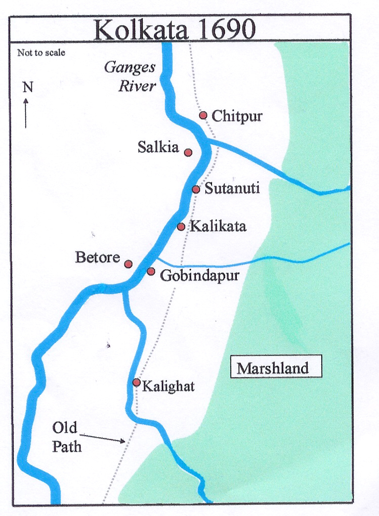
Default is list if up to 5 items, coll if more than 5-- Chitpur (or Chitpore) is a neighbourhood in North Kolkata in Kolkata district in the Indian state of West Bengal. Sometimes, the entire area along Chitpur Road is referred to as Chitpur, although the various localities have distinctive names.
History
Chitpur has existed for at least 400 years. It received its name from the goddess Chitteswari, who had a splendid temple here erected by Gobindram Mitter, where human sacrifices used to be offered. The lofty dome of the temple, which was known as Nabarutna or the shrine of nine jewels, fell during the earthquake of 1737, and it is now in ruins.
According to another source, the area was earlier named Chitrapur. It is referred to in Bipradas Pipilai's poem Manasamangal in 1495, but it could be a later interpolation. According to it, Chitpur was home to Chakrapani, Commander-in-Chief of the Nawab of Bengal's army, and had a flourishing colony of artists. It refers to one Gobinda Ghosh as founder of the Chitteswari temple in 1610. The most notorious bandit of the region was Chitey Dakat, who offered human sacrifices at the temple. The area could also have acquired its name from him.
The East India Company obtained from the Mughal emperor Farrukhsiyar, in 1717, the right to rent from 38 villages surrounding their settlement. Of these 5 lay across the Hooghly in what is now Howrah district. The remaining 33 villages were on the Calcutta side. After the fall of Siraj-ud-daulah, the last independent Nawab of Bengal, it purchased these villages in 1758 from Mir Jafar and reorganised them. These villages were known en-bloc as Dihi Panchannagram and Chitpur was one of them. It was considered to be a suburb beyond the limits of the Maratha Ditch.
There was a house and garden of Mahmed Reza Khan, the Chitpur Nawab, to whom the administration of Bengal was assigned for several years after the British East India Company acquired the dewani of Bengal from the Mughal emperors in Delhi. The Chitpur Nawab lived on terms of intimacy with the 'powers' of the day and was accounted by them as a personage of first rank. The foreign governors—Danish, French and Dutch—on their visits to Kolkata from Serampore, Chandannagar and Chinsurah, made it a practice to halt at Chitpur on their way to the Government House.
The Circular Canal joins the Hooghly River at Chitpur. Early in the 20th century a large lock and tidal basin had been constructed, at the mouth of the canal.
Entally, Manicktala, Beliaghata, Ultadanga, Chitpur, Cossipore, parts of Beniapukur, Ballygunge, Watgunge, Ekbalpur, Garden Reach and Tollygunj were added to Kolkata Municipal Corporation in 1888. Garden Reach was later taken out.
Chitpur Road
Barisha]], where the junior branch resided, to Halisahar, beyond Barrackpore, which was the seat of the senior branch.
Along that old road, popular as pilgrim's path, dharamshalas and shops came up. Habitations grew around them and localities developed. They were self-descriptive. The chicken (murgi) market (hat) was Murgihata, twin (jora) bridges (sanko) over a creek distinguished Jorasanko, butchers (kasais) slaughtered animals at Kasitola, and the potters (kumors) spun the river clay on wheels at Kumortuli. Later, they took to making clay idols in demand in the mansions that grew up all around. When the new Fort William was built in the 1750s at Gobindapur, the inhabitants of the disbanded village migrated northwards.
Chitpur Road was Kolkata's oldest road. Apart from the aristocracy, there have been common folks engaged in various trades. The distinctive Bengali panjika almanac was printed here. It was a centre for Battala books. So many things on Chitpore Road have been an integral part of Bengal's life and culture – the paan (betel leaf mouth refresher), the adda (stray gossiping), jatra shows and the brass band playing "He is a jolly good fellow" to enliven wedding receptions.
A part of Lower Chitpur Road rivalled the Chandni Chowk of Delhi before construction of Nakhoda Mosque in 1926. The last vestiges of Nawabi style were found along Chitpur Road. It was on this road that Raja Rammohun Roy built his Brahmo Sabha, which later became Adi Brahmo Samaj. The road was renamed Rabindra Sarani, after its most famous resident, Rabindranath Tagore. It is Kolkata's museum with communities and social groups from various parts of country and beyond finding a place in nooks along the road.
Jorasanko Thakur Bari, the home of the Tagore family now houses Rabindra Bharati University.
Corporation ward
In 1876, the peripheral areas of Kolkata were brought under the umbrella of a single Suburban Municipality. In 1889, the suburban area was split into five units of which one was the Suburban Municipality of Kashipur and Chitpur. In 1931, it was merged with Kolkata. Chitpur now forms ward no. 6 of Kolkata Municipal Corporation. With the Hooghly River on the west, it is surrounded by Cossipore, Bagbazar, Paikpara, Tala, Belgachia and Shyambazar on the other three sides. Across the Hooghly River is Salkia in Howrah.
Police district
Chitpur police station is part of the North and North Suburban division of Kolkata Police. Located at 19, Cossipore Road, Kolkata-700002, it has jurisdiction over Chitpur neighbourhood/ Ward no. 6, of Kolkata Municipal Corporation.
Amherst Street Women police station covers all police districts under the jurisdiction of the North and North Suburban division i.e. Amherst Street, Jorabagan, Shyampukur, Cossipore, Chitpur, Sinthi, Burtolla and Tala.
Railway passenger terminal
Chitpur is home to Kolkata railway station, the fourth and latest railway passenger terminal for the city. The first two stations, Howrah and Sealdah, were built more than a century ago and now both of them have reached the saturation point in capacity. The third one, Shalimar, which is under jurisdiction of South Eastern Railway, is located in Howrah, far away from the city centre. The new terminal has been named "Kolkata".
Transport
Cossipore Road (Sri Sri Ramakrishna Paramahansa Dev Sarani) is the artery of Chitpur. Buses ply along the road. The road is connected to B.T. Road (at Chunni Babu Bazar) with Lock Gate Road Overbridge. It is also connected to Bagbazar (Khirode Vidyavinode Avenue) with Chitpur Bridge over a canal. Chitpur Bridge was firstly inaugurated in 1937.
Bus
Private Bus
- 34B Dunlop - Esplanade
- 43 Dakshineswar - Esplanade
- 242 Cossipore 4B - Esplanade
CSTC Bus
- S17A Ariadaha - Kudghat
Train
Besides Kolkata Station, Tala railway station and Bagbazar railway station (both are on Kolkata Circular Railway line) are also located nearby.
In popular culture
Chitpur is the setting for the 2012 Malayalam novel Aarachaar () by K. R. Meera, which won many awards.
References
References
- Cotton, H.E.A., ''Calcutta Old and New'', [1909] (1980), rev. ed., pp. 221, 283, General Printers and Publishers Pvt Ltd.
- Gupta, Bunny and Chaliha, Jaya, ''Chitpur'', in ''Calcutta, the Living City'', Vol I, edited by Sukanta Chaudhuri, pp. 27-30, Oxford University Press, {{ISBN. 978-0-19-563696-3.
- "District Census Handbook Kolkata, Census of India 2011, Series 20, Part XII A". Directorate of Census Operations, West Bengal.
- Cotton, H.E.A., ''Calcutta Old and New'', first published 1909/reprint 1980, pages 103-4 and 221, General Printers and Publishers Pvt. Ltd.
- Nair, P.Thankappan, ''The Growth and Development of Old Calcutta'', in ''Calcutta, the Living City'', Vol. I, pp. 14-15, Edited by Sukanta Chaudhuri, Oxford University Press, 1995 edition.
- Cotton, H.E.A., p. 221,
- Cotton, H.E.A., p. 109.
- Bagchi, Amiya Kumar, ''Wealth and Work in Calcutta, 1860-1921'', in ''Calcutta, the Living City'', Vol. I, p. 213.
- Cotton, H.E.A., p. 283
- "streets in motion: the making of infrastructure, property, and political culture in twentieth-century Calcutta". Cambridge University Press.
- [https://news.bbc.co.uk/1/shared/spl/hi/pop_ups/05/south_asia_india0s_changing_folk_theatre/html/2.stm Jatra 2] ''[[BBC News]]'', 2005.
- Chakraborty, Manish and Hanig, Florian. Bialobrzeski, Peter.(Ed.) (2008) ''Calcutta - Chitpur Road Neighborhoods''. Hatje Cantz. {{ISBN. 978-3-7757-2106-6
- Chakraborty, Satyesh C., ''The Growth of Calcutta in the Twentieth Century'', in ''Calcutta, the Living City'', Vol II, edited by Sukanta Chaudhuri, p. 2, Oxford University Press, {{ISBN. 978-0-19-563697-0.
- ''Detailed Maps of Kolkata'', D.P.Publication & Sales Concern.
- "Kolkata Police". KP.
- Kolkata: Detail Maps of 141 Wards with Street Directory, Fourth Impression 2003, Map No. 4, D.P.publication and Sales Concern, 66 College Street, Kolkata - 700 073.
- [http://www.flonnet.com/fl2225/stories/20051216002509200.htm Online version of Frontline magazine dated 3-16 Dec 2005] {{webarchive. link. (12 February 2012)
- "News article dated January-31-2006 from expressindia.com".
- Google maps
- "Chitpur Bridge".
This article was imported from Wikipedia and is available under the Creative Commons Attribution-ShareAlike 4.0 License. Content has been adapted to SurfDoc format. Original contributors can be found on the article history page.
Ask Mako anything about Chitpur — get instant answers, deeper analysis, and related topics.
Research with MakoFree with your Surf account
Create a free account to save articles, ask Mako questions, and organize your research.
Sign up freeThis content may have been generated or modified by AI. CloudSurf Software LLC is not responsible for the accuracy, completeness, or reliability of AI-generated content. Always verify important information from primary sources.
Report