From Surf Wiki (app.surf) — the open knowledge base
Chiang Mai province
Largest province of Thailand

Largest province of Thailand
| Field | Value |
|---|---|
| name | Chiang Mai |
| official_name | จังหวัดเชียงใหม่ · |
| other_name | |
| settlement_type | Province |
| translit_lang1 | Other |
| founder | Mangrai |
| image_flag | Flag of Chiang Mai.svg |
| image_seal | Seal Chiang Mai.svg |
| image_skyline | {{multiple image |
| border | infobox |
| total_width | 250 |
| image_style | border:1; |
| perrow | 2/2/2/2 |
| image1 | Phra That Doi Suthep 02.jpg |
| image2 | Near the Top of Doi Inthanon 2014.jpg |
| image3 | Misty Morning at Doi Angkhang Mountain, Chiangmai, Thailand.jpg |
| image4 | Obluang national park, Chiangmai province, Thailand.jpg |
| image5 | พระธาตุวัดพระสิงห์ - Pagoda of Wat Phra Singh 1.jpg |
| image6 | Hor Thum at CMU.JPG |
| image7 | Mae sa2.jpg |
| image8 | Chiangmai-zoo02.jpg |
| image_caption | From left to right, top to bottom : Wat Phra That Doi Suthep, Doi Inthanon, Doi Ang Khang, Op Luang National Park, Wat Phra Singh, Chiang Mai University, Mae Sa Waterfall, Chiang Mai Zoo |
| mottoes | ดอยสุเทพเป็นศรี ประเพณีเป็นสง่า บุปผชาติล้วนงามตา นามล้ำค่านครพิงค์ |
| ("Famed Doi Suthep. Elegant traditions. Beautiful blossoms. Invaluable name of Nakhonphing.") | |
| coordinates | |
| anthem | นครเชียงใหม่ |
| Nakhon Chaing Mai | |
| image_map | Thailand Chiang Mai locator map.svg |
| map_caption | Chiang Mai in Thailand |
| seat_type | Capital |
| seat | Chiang Mai |
| leader_title | Governor |
| leader_name | Nirat Pongsitthaworn |
| (since 2022) | |
| leader_title1 | PAO Chief Executive |
| leader_name1 | Pichai Lertpongadisorn |
| area_footnotes | |
| area_total_km2 | 22,311 |
| area_rank | 1st |
| population_footnotes | |
| population_total | 1,799,019 |
| population_as_of | 2024 |
| population_rank | 4th |
| population_density_km2 | 80 |
| population_density_rank | 61st |
| demographics_type2 | GDP |
| demographics2_footnotes | |
| demographics2_title1 | Total |
| demographics2_info1 | baht 232 billion |
| (US$8.0 billion) (2019) | |
| demographics_type1 | Human Achievement Index |
| demographics1_footnotes | |
| demographics1_title1 | HAI (2022) |
| translit_lang1_info2 | 清邁 / 清迈 |
| cêng1 mai6 | |
| Qīngmài | |
| translit_lang1_type2 | Chinese |
| demographics1_info1 | 0.6179 "low" |
| Ranked 68th | |
| timezone1 | ICT |
| utc_offset1 | +7 |
| postal_code_type | Postal code |
| postal_code | 50xxx |
| area_code_type | Calling code |
| area_code | 052 & 053 |
| iso_code | TH-50 |
| registration_plate | เชียงใหม่ |
| blank_name_sec2 | Accession into Siam (Thailand) |
| blank_info_sec2 | 1910 |
| website | |
| translit_lang1_info1 | |
| translit_lang1_type1 | Northern Thai |
| native_name | เชียงใหม่ |
| nickname | Nakhon Phing (Thai: นครพิงค์) |
the first-level administrative division in Thailand
("Famed Doi Suthep. Elegant traditions. Beautiful blossoms. Invaluable name of Nakhonphing.") Nakhon Chaing Mai (De facto) (since 2022) (US$8.0 billion) (2019) cêng1 mai6 Qīngmài Ranked 68th
Northern Thai with Tai Tham script (bottom)
Chiang Mai is the largest province (changwat) of Thailand by area. It lies in upper northern Thailand and has a population of 1.78 million people. It is bordered by Chiang Rai to the northeast, Lampang and Lamphun to the south, Tak to the southwest, Mae Hong Son to the west, and Shan State of Burma to the north. The capital, Chiang Mai, is 685 km north of Bangkok.
Geography
Chiang Mai province is about 685 km from Bangkok in the Mae Ping River basin and is on average at 300 m elevation. Surrounded by the mountain ranges of the Thai highlands, it covers an area of approximately 22,311 km2. The mountains of the Daen Lao Range (ทิวเขาแดนลาว) at the north end of the province, the Thanon Thong Chai Range (เทือกเขาถนนธงชัย) with the highest mountain in Thailand, Doi Inthanon at 2,565 m, stretching in a north–south direction, and the Khun Tan Range in the east of the province are covered by rain forest. The Mae Ping, one of the major tributaries of the Chao Phraya River, originates in the Daen Lao mountains. Several national parks are in the province: Doi Inthanon, Doi Suthep-Pui, Ob Luang, Sri Lanna, Huai Nam Dang, Mae Wang, and Pha Daeng. The total forest area is 15,404 km² or 69.6 percent of provincial area.
National parks
Fourteen of the fifteen national parks of region 16 (Chiang Mai), Mae Ping National Park is not in Chiang Mai province, form protected areas in Chiang Mai province. (Visitors in fiscal year 2024).
| Namphu Chet Si National Park |
|---|
Wildlife sanctuaries
Three of the four wildlife sanctuaries in region 16 (Chiang Mai), Omkoi wildlife sanctuary is not in Chiang mai province, form protected areas in Chiang Mai province.
Climate
Chiang Mai has a tropical wet and dry climate (Köppen Aw), tempered by the low latitude and moderate elevation, with warm to hot weather year-round, though nighttime conditions during the dry season can be cool and are much lower than daytime highs. The maximum temperature ever recorded is 42.4 °C in May 2005.
Demographics
Of the population, 13.4 percent in the province are members of hill tribes
- Northern Thai people or Tai Yuan native to nine provinces in Northern Thailand, principally in the area of the former kingdom of Lan Na.
- Tai Lue live in dwellings of usually only a single room wooden house built on high poles. They are skilled in weaving.
- Tai Yai, Burmese in origin, harvest rice, farm, raise cattle and trade. Their craftsmanship lies in weaving, pottery, wood carving and bronze ware.
- Akha the largest population of any hill tribe in the region. Originating from Tibet and Southern China, they dwell on high ground around 1,200. m above sea-level. Within their villages they build a spirit gateway to protect them from evil spirits.
- Hmong from southern China. Prefer higher elevations. They raise livestock and grow rice, corn, tobacco, and cabbage. Known for their embroidery and silver.
- Karen occupy valleys and riverbanks.
- Lahu from southern China and live in high areas. They are known as hunters and planters.
- Lisu from southern China and Tibet are renowned for their colorful dress and also build their dwellings on high poles. They harvest rice and corn and their men are skilled in hunting.
- Yao reside on mountainsides and grow corn and other crops. They are skilled blacksmiths, silversmiths and embroiders.
- Mon native to Haripuñjaya Where the capital was at Lamphun
Symbols
The seal of the province shows a white elephant in a glass pavilion. The white elephant is a royal symbol in Thailand, and it is depicted to remember the offering of a white elephant by Thammalangka, a ruler of Chiang Mai, to his overlord, King Rama II of Bangkok. The pavilion symbolizes that Buddhism prospered in Chiang Mai, especially when in 1477 the teachings of Buddha, the Tripitaka, were reviewed.
The provincial flower and tree is the "flame of the forest" (Butea monosperma). The edible cyprinid fish "black sharkminnow" (Labeo chrysophekadion) is the provincial aquatic life.
The provincial slogan is In the shadow of Mount Doi Suthep, blessed with rice customs and traditions, beautiful wild flowers, magnificent Nakhon Phing.
History
Main article: Kingdom of Chiang Mai, Lan Na Kingdom
The city of Chiang Mai, the capital of Chiang Mai province, was also capital of the Lanna Kingdom after its founding in 1296, during the same period of time as the establishment of the Sukhothai Kingdom. From then, Chiang Mai not only became the capital and cultural core of the Lanna Kingdom, but also the centre of Buddhism in northern Thailand. King Meng Rai built many temples in the region.
In 1558, Chiang Mai became a colony of the First Toungoo Empire. Chiang Mai remained its colony for more than 200 years, until the Burmese–Siamese War (1775–1776). In 1774 the Burmese colonial regime were finally driven out of Chiang Mai by a coalition of Lanna and Siamese forces and it then became a tributary state of Siam, which later installed a Lanna chieftain ally, Kawila, to independently rule over Lampang and Chiang Mai region as a monarch.
In the reign of King Rama V of Siam, under his administrative centralization policy and due to the ineptitude of Chiang Mai's ruling family, Chiang Mai eventually lost its independence, was annexed and became a second level subdivision of Siam.
From 1933 on, Chiang Mai received its status as a "province" of Siam and has remained so until the present day.
Kingdom of Ngoenyang before 1292
Seal of Lanna Kingdom.png Kingdom of Lanna 1292–1579
WikiProject Myanmar peacock.svg Kingdom of Lanna 1579-1775
Seal of Chiang Mai (1802–1899).png Kingdom of Chiang Mai 1775-1899
Thailand Kingdom of Siam 1899-1932
Thailand Kingdom of Thailand 1932–present
Religion
Administrative divisions and postal codes
Chiang Mai is subdivided into 25 districts (amphoe). The districts are further divided into 204 subdistricts (tambon) and 2,066 villages (muban).
- Mueang Chiang Mai: 50000
- Chom Thong: 50160
- Mae Chaem: 50270
- Chiang Dao: 50170
- Doi Saket: 50220
- Mae Taeng: 50150
- Mae Rim: 50180
- Samoeng: 50250
- Fang: 50110
- Mae Ai: 50280
- Phrao: 50190
- San Pa Tong: 50120
- San Kamphaeng: 50130
- San Sai: 50210
- Hang Dong: 50230
- Hot: 50240
- Doi Tao: 50260
- Omkoi: 50310
- Saraphi: 50140
- Wiang Haeng: 50350
- Chai Prakan: 50320
- Mae Wang: 50360
- Mae On: 50130
- Doi Lo: 50160
- Galyani Vadhana: 50270
Local government
As of 26 November 2019 there are: one Chiang Mai Provincial Administration Organisation (ongkan borihan suan changwat) and 121 municipal (thesaban) areas in the province. Chiang Mai has city (thesaban nakhon) status. Mae Jo, Mae Hia, Mueang Kaen Phatthana and Ton Pao have town (thesaban mueang) status. Further 116 subdistrict municipalities (thesaban tambon). The non-municipal areas are administered by 89 Subdistrict Administrative Organisations - SAO (ongkan borihan suan tambon).
Human achievement index 2022
| Province Chiang Mai, with an HAI 2022 value of 0.6179 is "low", occupies place 68in the ranking. |
|---|
Since 2003, the United Nations Development Programme (UNDP) in Thailand has tracked progress on human development at sub-national level using the Human achievement index (HAI), a composite index covering all the eight key areas of human development. The National Economic and Social Development Board (NESDB) took over this task in 2017.
| 62–77 | "Low" |
|---|
| [[File:HAI 2022 rankings.svg | 950px]] |
|---|
Transportation

- Road: Chiang Mai is on Highway 11, the only 2-digit road number in the province. Other roads connect the city of Chiang Mai with the north and south of the province, as well as with the east towards Chiang Rai province.
- Train: Chiang Mai railway station is the northern terminus of the Northern Line, operated by the State Railway of Thailand.
- Air: Chiang Mai International Airport (CNX) is one of the seven Thai international airports under the aegis of the Airports of Thailand Public Company Limited (AOT). As Chiang Mai International Airport is the major gateway to northern Thailand, it plays an important role in promoting travel and tourism throughout the northern region. Today, 14 airlines serve the airport and more than 3,000,000 passengers, 15,000 flights, and 16,000 tons of cargo are handled annually.
- Songthaew
Tourism
Chiang Mai province is the tourist hub of the north and one of Thailand's most important tourist destinations. It is considered one of the most scenic provinces in the country due to its mountain ranges, valleys, flora, and fauna. For example, the Hang Dong Canyon is coveted as a great tourist attraction. Furthermore, unlike most of Thailand, in some months, the climate in the north and Chiang Mai is cool, fresh, and misty.
Location protected areas
| 9 | Mae Wang |
|---|
| 17 | Samoeng |
|---|
|}
Health
Each amphoe of Chiang Mai has its own hospital, but among the largest are located in Mueang Chiang Mai District and include Maharaj Nakorn Chiang Mai Hospital and Nakornping Hospital.
Local products
Chiang Mai is a handicrafts centre, with a variety of antiques, silver jewellery, and embroidery, Thai silks and cottons, basketry, celadon, silverware, furniture, lacquerware, woodcarvings, and parasols.
Local culture
The north of Thailand's culture is Lanna in origin and the people are proud of their northern roots. The region is home to distinctive foods, music, arts, way of life, and even language. Chiang Mai is home to various hill tribes and their own distinctive cultures.
Local food
- Nam phrik ong is a type of Nam phrik chili paste which is made of minced pork and tomatoes. It is usually eaten with soft-boiled vegetables, pork crackling, or deep-fried crunchy rice cakes.
- Nam phrik num meaning "chili paste young man", is another kind of paste which can be eaten with pork crackling.
- Sai ua is a local sausage that is very aromatic and spicy and is usually eaten with sticky rice.
- Kaeng meaning "curry", is not made with coconut milk in the north.
- Kaeng hang-le is northern-style pork curry
- Kaeng om is a spicy curry consisting of intestines
- Kaeng khae is a spicy curry consisting mainly of vegetables.
- Khanom chin nam ngiao is a traditional northern noodle dish with chicken or pork.
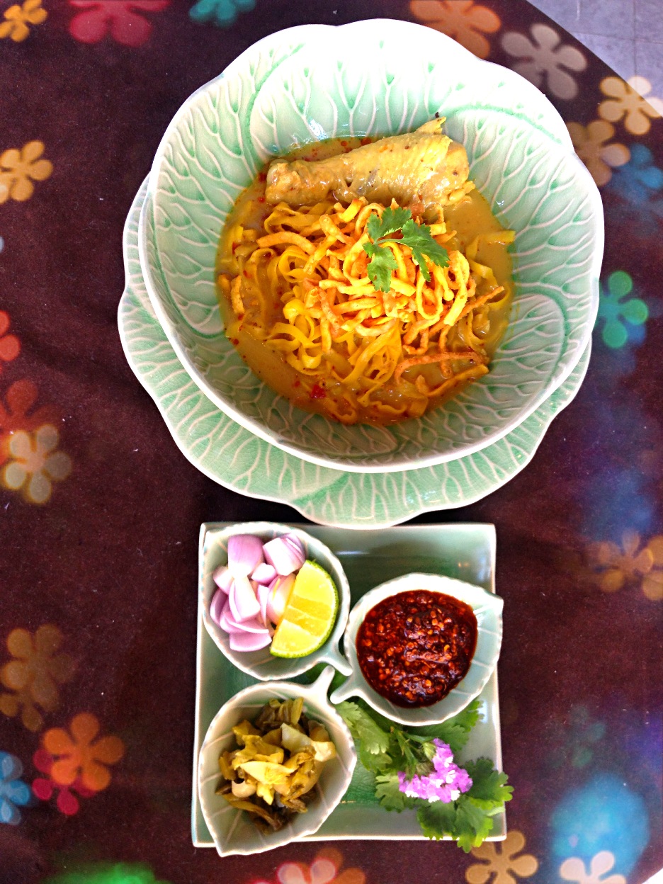
- Khao soi is a noodle dish which can be made from chicken, pork, or beef made with coconut milk and garnished with chopped fresh shallots, pickled cabbage, chilli paste to taste, and a slice of fresh lime.
Sports
There are two main sport stadia in Chiang Mai and its environs: 700th Anniversary Stadium and Province Stadium. 700th Anniversary Stadium is on Klongchonpratan Road, 7 km from Chiang Mai University. There are swimming pools, diving pool, basketball arena, and 11 tennis courts.
File:Chiang Mai, Yi Peng Festival 1.jpg|Chiang Mai, Yi Peng Festival File:Loi Krathong 2010 John Shedrick.jpg|People floating krathong rafts during the Loi Krathong festival in Chiang Mai
Sister cities
The province is twinned with eight provinces/states.
- PRC Shanghai, China (2000)
- Indonesia Yogyakarta, Indonesia (2007)
- PRC Qingdao, China (2008)
- PRC Chongqing, China (2008)
- Japan Hokkaido, Japan (2013)
- Turkey Bursa, Turkey (2013)
- Myanmar Chiang Tung, Myanmar (2014)
- PRC Chengdu, China (2015)
Notable inhabitants

- Thaksin Shinawatra (Thai: ทักษิณ ชินวัตร) (born 1949), politician and businessman
- Yingluck Shinawatra (Thai: ยิ่งลักษณ์ ชินวัตร) (born 1967), politician
Gallery
File:จุดชมวิว กม.41 อุทยานแห่งชาติดอยอินทนนท์.jpg|The viewpoint at the 41st km of the Highway 1009, Doi Inthanon File:Wild Himalaya Cherry's blooming at Doi suthep-pui national park.jpg|Prunus cerasoides blooming at Doi Suthep–Pui National Park File:Pong Dueat Hot Spring.jpg|Pong Dueat Hot Springs, Huai Nam Dang National Park File:Ob Khan National Park.jpg|Ob Khan National Park File:1112อุทยานแห่งชาติแม่วาง6.jpg|Mae Wang National park File:Chiang Dao National Park Chiang Mai.jpg|Doi Chiang Dao mountain File:ดอยหลวงเชียงดาว.jpg|Pha Daeng National Park in Chiang Dao District File:เทือกเขาหลวงเชียงดาว ในตอนเช้า.jpg|The mountains of Chiang Dao Wildlife Sanctuary in Chiang Dao District File:Cyornis whitei, Doi Chiang Dao NP, Thailand.jpg|A photo of a hill blue flycatcher in the Chiang Dao Wildlife Sanctuary File:Mae ta mann-09.JPG|Bathing elephants in the Taeng River File:Chiang Mai province road 1099 Omkoi.jpg|Mae Thun Noi, Omkoi File:2019 01 Fang River Chai Prakan District.jpg|The Fang River, part of the Mekong watershed, in Chai Prakan District File:Mae Ngat Somboon Chon.jpg|The lake of Mae Ngat Somboon Chon Dam, Si Lanna National Park File:Wat Phrathat Doi Suthep 08.jpg|Wat Phra That Doi Suthep File:Chiang Mai - East gate of the city wall - 0001.jpg|East gate (Tha Phae Gate) of the city wall File:CF-sunset.jpg|Shopping Mall in Chiang Mai File:Thaton countryside, Thailand.jpg|Thaton countryside File:ThaiGirls.jpg|alt=|Hmong girls File:Butea monosperma bij Tha Phae Gate, Chiang Mai P1040493a.jpg|alt=|The "flame of the forest"
Notes
References
References
- (2 December 2022). "รายนามผู้ว่าราชการจังหวัด". Ministry of Interior (Thailand).
- [http://www.chiangmai.go.th/managing/public/D4/4D12Dec2023134018.pdf As of 2023 total area of Chiang Mai province is 22,311 sq.km]
- "Official statistics registration systems". Department of Provincial Administration (DOPA).
- (July 2019). "''Gross Regional and Provincial Product, 2019 Edition''". Office of the National Economic and Social Development Council (NESDC).
- "ข้อมูลสถิติดัชนีความก้าวหน้าของคน ปี 2565 (PDF)".
- [https://ratchakitcha.soc.go.th/documents/17135043.pdf ประกาศกระทรวงมหาดไทย เรื่อง การกำหนดเขตตำบลในท้องที่อำเภอสามเงา จังหวัดตาก (ฉบับที่ ๒) พ.ศ. ๒๕๖๓]
- [https://ratchakitcha.soc.go.th/documents/20667.pdf ประกาศกระทรวงมหาดไทย เรื่อง การกำหนดเขตตำบลในท้องที่อำเภอดอยเต่า จังหวัดเชียงใหม่ (ฉบับที่ ๒) พ.ศ. ๒๕๖๗]
- "Doi Inthanon National Park".
- "Doi Suthep-Pui National Park".
- "Ob Luang National Park".
- "Si Lanna National Park".
- "Huai Nam Dang National Park".
- "Mae Wang National Park".
- "Pha Daeng National Park".
- "Table 2 Forest area Separate province year 2019". Royal Forest Department.
- (December 2020). "ข้อมูลพื้นที่อุทยานแห่งชาติ ที่ประกาศในราชกิจจานุบกษา 133 แห่ง".
- "ข้อมูลพื้นที่อุทยานแห่งชาติ (เตรียมการ) 22 แห่ง".
- "สถิตินักท่องเที่ยวที่เข้าไปอุทยนห่งชาติ ปีงบประมาณ พ.ศ. 2567".
- "Daily Climate Weather Data Statistics". Geodata.us.
- "Office of the Royal Society". สำนักงานราชบัณฑิตยสภา.
- "Chiang Mai".
- "A Brief History of Chiang Mai".
- "About Chiang Mai".
- The code 25 was assigned to a planned district named Wiang Kham, which however wasn't created.
- (26 November 2019). "Number of local government organizations by province". Department of Local Administration (DLA).
- "Chiang Mai International Airport".
- "Shopping Chiang Mai".
- "Archived copy".
- "MOU of the Establishment of Friendship between Province of Chiang Mai and Prefecture of Hokkaido".
- "ประยุทธ์เยือนพม่า-ขอสื่ออย่าระบุสัญชาติผู้ต้องหาเกาะเต่า".
This article was imported from Wikipedia and is available under the Creative Commons Attribution-ShareAlike 4.0 License. Content has been adapted to SurfDoc format. Original contributors can be found on the article history page.
Ask Mako anything about Chiang Mai province — get instant answers, deeper analysis, and related topics.
Research with MakoFree with your Surf account
Create a free account to save articles, ask Mako questions, and organize your research.
Sign up freeThis content may have been generated or modified by AI. CloudSurf Software LLC is not responsible for the accuracy, completeness, or reliability of AI-generated content. Always verify important information from primary sources.
Report