From Surf Wiki (app.surf) — the open knowledge base
Cheviot, New Zealand
Town in Canterbury, New Zealand
Town in Canterbury, New Zealand
| Field | Value |
|---|---|
| name | Cheviot |
| native_name_lang | |
| settlement_type | Town |
| image_skyline | CheviotMainStreet3.JPG |
| image_alt | A straight street, divided by painted lines, passing through a town. The street is lined by parked vehicles, trees and buildings. Two men dressed in t-shirts and short are crossing the road from left to right in the middle distance. |
| image_caption | Hall St (State Highway 1), the main street of Cheviot |
| mapframe | yes |
| mapframe-zoom | 6 |
| coordinates | |
| subdivision_type | Country |
| subdivision_name | New Zealand |
| subdivision_type1 | Region |
| subdivision_name1 | Canterbury |
| subdivision_type2 | Territorial authority |
| subdivision_name2 | Hurunui District |
| subdivision_type3 | Ward |
| subdivision_name3 | East Ward |
| seat_type | Electorates |
| seat | |
| leader_title | Territorial Authority |
| leader_name | Hurunui District Council |
| leader_title1 | Regional council |
| leader_name1 | Environment Canterbury |
| leader_title2 | Mayor of Hurunui |
| leader_name2 | |
| leader_title3 | Kaikoura MP |
| leader_name3 | |
| leader_title4 | Te Tai Tonga MP |
| leader_name4 | |
| elevation_m | 60 |
| area_footnotes | |
| area_total_km2 | 1.05 |
| population_footnotes | |
| population_as_of | |
| population_total | |
| population_density_km2 | auto |
| timezone1 | New Zealand Standard Time |
| utc_offset1 | +12 |
| timezone1_DST | New Zealand Daylight Time |
| utc_offset1_DST | +13 |
| postal_code_type | Postcode |
| postal_code | 7310 |
| area_code | 03 |
| website | |
| blank_name | Local iwi |
| blank_info | Ngāi Tahu |
| mapframe-zoom = 6 Cheviot () is a town in the Hurunui District of north Canterbury, on the east coast of the South Island of New Zealand. It is located on State Highway 1, approximately 112 km north of Christchurch and 68 km south of Kaikōura.
History and naming
The government under Minister of Lands John McKenzie bought the Cheviot Hills estate between 1892 and 1893 from the descendants of William Robinson. The Cheviot Hills estate was broken into 54 farms and a township, which was originally called McKenzie. This name was "in widespread use for a decade or two" but gradually fell into disuse. The Cheviot county council was formed 1895. In 1901 the township had a population of 113.
A large earthquake measuring 6.9 hit near Cheviot on 16 November 1901. A number of buildings were badly damaged and one death was reported.
The post office was always known as Cheviot and by at least 1913 the township too was generally known as Cheviot. Cheviot Hills estate had been named by its original lease holder, John Scott Caverhill, after his home country, the Cheviot Hills straddling the Anglo-Scottish border.
The Robinson homestead burned down in 1936. Its foundations and grounds became part of the Cheviot Hills Domain, with the homestead's original front steps part of the cricket pavilion.
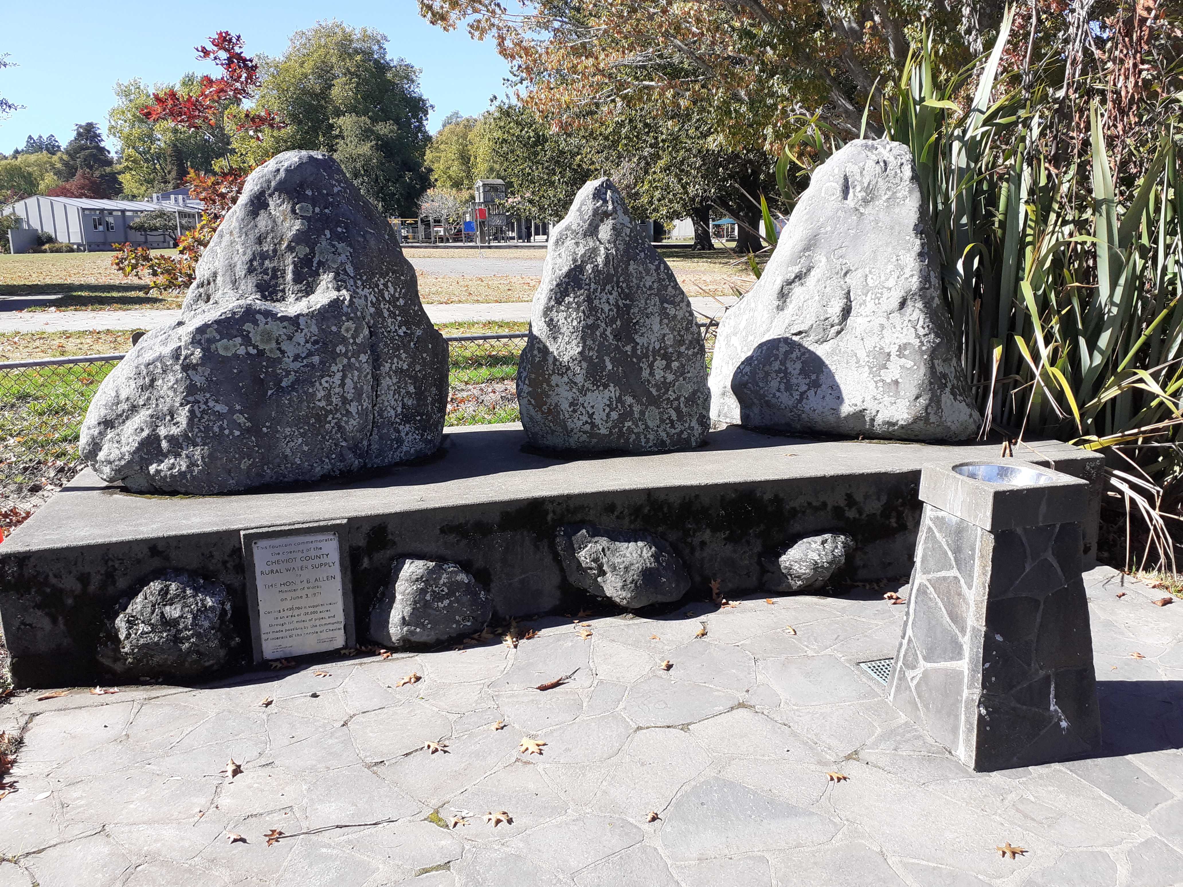
The Cheviot County rural water supply was opened in 1971. It cost $420,000 and supplies water to an area of 128,000 acres through 190 miles of pipes. A fountain, which sits outside the local school, was built to commemorate the event.
Demographics
Cheviot is defined by Statistics New Zealand as a rural settlement and covers 1.05 km2. It had an estimated population of as of with a population density of people per km2. Cheviot is part of the larger Parnassus statistical area.
Cheviot had a population of 372 at the 2018 New Zealand census, an increase of 6 people (1.6%) since the 2013 census, and a decrease of 18 people (−4.6%) since the 2006 census. There were 177 households, comprising 183 males and 186 females, giving a sex ratio of 0.98 males per female, with 60 people (16.1%) aged under 15 years, 39 (10.5%) aged 15 to 29, 144 (38.7%) aged 30 to 64, and 129 (34.7%) aged 65 or older.
Ethnicities were 87.1% European/Pākehā, 21.8% Māori, 4.0% Pasifika, 2.4% Asian, and 0.8% other ethnicities. People may identify with more than one ethnicity.
Although some people chose not to answer the census's question about religious affiliation, 45.2% had no religion, 40.3% were Christian, 1.6% had Māori religious beliefs, 0.8% were Muslim and 0.8% had other religions.
Of those at least 15 years old, 18 (5.8%) people had a bachelor's or higher degree, and 93 (29.8%) people had no formal qualifications. 21 people (6.7%) earned over $70,000 compared to 17.2% nationally. The employment status of those at least 15 was that 108 (34.6%) people were employed full-time, 63 (20.2%) were part-time, and 9 (2.9%) were unemployed.
The region
Cheviot is a service town for highway traffic and for a pastoral farming district that is currently predominant in sheep farming. Based in the township are a volunteer fire and ambulance services and one full-time police officer. Surrounding settlements include:
Domett
Originally a railway town, Domett is now only populated by farms and a petrol station. Next to the Old Main Road/Hurunui Mouth Road junction is the old Domett Railway Station, relocated and refurbished as a cafe. Domett Service Station provides after-hours sale of fuel (with surcharge): most service stations in the area close around 6pm.
Spotswood
Spotswood has an old hall that is still used regularly, and mainly consists of farms around Waiau East Road.
Parnassus
Parnassus has a higher population than the other settlements, although the local Parnassus School was closed in 2008. The famous Waiau River road/rail bridge was here, before being abandoned and replaced with a new road bridge. Prior to the opening of the old bridge in the 1930s a ferry across the river carried goods north and south. The Waiau River ends not far away; however, access to the river mouth must be made over farm property with the owners' permission. On the State Highway north of Parnassus is Leader Road which leads to the townships of Waiau, Rotherham, Culverden and Hanmer Springs.
Gore Bay
Main article: Gore Bay, New Zealand

Gore Bay is a surfing beach with summer beach houses and 14 permanent residents. There are two local camping grounds, each with beach access and business. It is a popular New Year's Eve venue.
Of note is Cathedral Gully, a spectacular weathered clay canyon.
Port Robinson

Once a prospering port, Port Robinson is now an abandoned wreck. The old wharf may still be seen, but it is in a dangerous state of disrepair.
Stonyhurst Station
Stonyhurst is a farming station in the Blythe Valley, southwest of Cheviot.
It was founded in 1851 by Frederick Weld and Charles Clifford. He had gained his impression when walking from Lyttelton to Flaxbourne, in Marlborough. Clifford landed sheep on the beach just south of the Blythe River which was later known as Stonyhurst Station, named after Stonyhurst College in England where they were both educated.
The farm originally occupied nearly 30000 ha, the whole of the Blythe Valley. About 12000 ha was sold in 1863, and a further 4000 ha a decade later. In about 1900, much of the rest of the land was subdivided. The current station is about one tenth of the original area.
The area is described by the local authority as "a potentially significant natural area", and the manager's cottage is a Category II protected building under the Historic Places Act.
Education

Schooling in Cheviot commenced in 1894. The first school was the McKenzie School, where the A&P Showgrounds are today. The name changed to Cheviot School in 1931. From its inception, the school provided primary education up to Form Two. In 1937, it became the Cheviot District High School.
Cheviot Area School is a composite, co-educational school for Year 1 to 13 students. It also has a wider role providing continuing education, facilities and support for community groups. The closest main contributing school, Parnassus, a year 1-6 school, closed in 2008. It had a roll of as of .
The large oak trees in the school grounds were planted to commemorate those former students who died in World War 2.
Cheviot Area School competes in the Canterbury Area Schools Association Festival sporting competition with schools in Akaroa, Amuri, Hawarden, Oxford, and Rangiora. It also takes part in international exchanges with schools in Japan and Canada.
The township has two preschools, Cheviot Learning Centre and The Tree Hut.
Climate
The mean yearly highest temperature for Cheviot from 2008–2024 was 34.8 °C.
| Jan record high C = 37.9 | Feb record high C = 37.8 | Mar record high C = 35.4 | Apr record high C = 30.4 | May record high C = 28.2 | Jun record high C = 24.0 | Jul record high C = 22.6 | Aug record high C = 26.3 | Sep record high C = 25.2 | Oct record high C = 29.8 | Nov record high C = 33.1 | Dec record high C = 36.1 | year record high C = 37.9 |Jan record low C = 0.0 |Feb record low C = 0.0 |Mar record low C = -4.4 |Apr record low C = -3.3 |May record low C = -6.3 |Jun record low C = -7.9 |Jul record low C = -8.1 |Aug record low C = -6.0 |Sep record low C = -4.9 |Oct record low C = -4.4 |Nov record low C = -3.0 |Dec record low C = -2.0 |year record low C = -8.1 |access-date = 19 May 2024}}{{cite web |access-date = 15 May 2024}}
References
--
References
- Brooking, Tom. "McKenzie, John 1839–1901".
- Gardner, William James. "Robinson, William - Biography".
- (30 August 2012). "Subdividing Cheviot Hills - roadside stories". Ministry for Culture and Heritage.
- "[Cheviot and McKenzie] {{!}} NZETC".
- "Major New Zealand earthquakes since 1855 - New Zealand Parliament".
- Wilson, John. "Cheviot Kingdom to County". Rangiora Printing Service, 1993, page 151. {{Listed Invalid ISBN. 0-473-10321-5. The difference in spelling between politician John McKenzie and the MacKenzie township is attributed to a mistake made by the then Commissioner of Crown Lands, Canterbury, John Marchant, on an early map.
- Reed, A. W.. (2010). "Place Names of New Zealand". Raupo.
- "Cheviot's History".
- Plaque on the fountain.
- "ArcGIS Web Application".
- {{NZ census place summary 2018. parnassus. Parnassus
- Cyclopedia of New Zealand. "Cheviot and McKenzie". NZETC.
- {{NZ census 2018. 7023857 and 7023858
- Silverstripe. "Parnassus Hall · Hurunui District Council".
- Crean, Mike. (8 March 2008). "Where a station once grew". [[The Press]].
- (September 2010). "Natural Environment". Hurunui District Council.
- (September 2010). "Heritage". Hurunui District Council.
- "Cheviot Area School Official School Website".
- "Cheviot Area School Education Review Office Report". [[Education Review Office]].
- "Cheviot Area School Ministry of Education School Profile". [[Ministry of Education (New Zealand).
- Plaque in the school grounds
- "CliFlo -The National Climate Database (Agent number: 31832)". NIWA.
This article was imported from Wikipedia and is available under the Creative Commons Attribution-ShareAlike 4.0 License. Content has been adapted to SurfDoc format. Original contributors can be found on the article history page.
Ask Mako anything about Cheviot, New Zealand — get instant answers, deeper analysis, and related topics.
Research with MakoFree with your Surf account
Create a free account to save articles, ask Mako questions, and organize your research.
Sign up freeThis content may have been generated or modified by AI. CloudSurf Software LLC is not responsible for the accuracy, completeness, or reliability of AI-generated content. Always verify important information from primary sources.
Report