From Surf Wiki (app.surf) — the open knowledge base
Charsadda District, Pakistan
| Field | Value | |
|---|---|---|
| name | Charsadda District | |
| native_name | {{nq | ضلع چارسدہ}} |
| {{script/Arabic | چارسدې ولسوالۍ}} | |
| settlement_type | District of Khyber Pakhtunkhwa | |
| image_skyline | {{Photomontage | |
| size | 250 | |
| photo1a | Bacha Khan Square In Charsadda.jpg | |
| photo2a | Bala Hisar - Charsadda - Northern Mound.JPG | |
| image_caption | Top: Bottom: Bacha Khan Square in Charsadda | |
| Bala Hisar mound | ||
| image_map | ||
| map_caption | Charsadda District (red) in Khyber Pakhtunkhwa | |
| subdivision_type | Country | |
| subdivision_name | Pakistan | |
| subdivision_type1 | Province | |
| subdivision_name1 | Khyber Pakhtunkhwa | |
| subdivision_type2 | Division | |
| subdivision_name2 | Peshawar | |
| established_title | Established | |
| seat_type | Headquarters | |
| seat | Charsadda | |
| government_type | District Administration | |
| leader_title | Deputy Commissioner | |
| leader_name | Saad Hussain | |
| leader_title1 | District Police Officer | |
| leader_name1 | N/A | |
| leader_title2 | District Health Officer | |
| leader_name2 | N/A | |
| unit_pref | Metric | |
| area_total_km2 | 996 | |
| population_footnotes | ||
| population_as_of | 2023 | |
| population_total | 1835504 | |
| population_rural | 1,543,108 | |
| population_urban | 292,396 (15.93%) | |
| population_density_km2 | auto | |
| demographics2_title1 | Literacy rate | |
| demographics2_info1 | {{ | |
| timezone1 | PST | |
| utc_offset1 | +5 | |
| blank_name_sec1 | District Council | |
| blank1_name_sec1 | Number of Tehsils | |
| blank1_info_sec1 | 3 | |
| demographics1_title1 | Main language(s) | |
| demographics_type2 | Literacy | |
| demographics2_footnotes | ||
| demographics1_info1 | pushto, English, Pashto | |
| website | ||
| total_type | Total |
Bala Hisar mound bulleted list | Total: (53.94%) | Male: (66.55%) | Female: (40.36%)
Charsadda District (, ) is a district in the Peshawar Division of the Khyber Pakhtunkhwa province of Pakistan. Prior to its establishment as a separate district in 1998, it was a tehsil within the Peshawar District. Mohamedzai Pashtuns make up the majority of the population of the district along with other minor tribes settled as well such as Uthmankhel, Mohmand, Kakakhel, Khattak. The district headquarter is the town of Charsadda, which was once part of the Peshawar ex-metropolitan region.
Overview and history
The district lies between 34 and 03' and 34-38' north latitudes and 71-28' and 71-53' east longitudes. Charsadda is located in the west of the Khyber Pakhtunkhwa and is bounded by the Malakand District to the north, Mardan district to the east, Nowshera and Peshawar districts to the south and Mohmand district to the west. The district covers an area of 996 square kilometers.
Charsadda was once part of the kingdom of Gandhara. However, around 516 BC Gandhara became part of the seventh satrapy or province of the Achaemenid Empire and paid tribute to Darius the Great of Persia, until it was overthrown by Alexander the Great in the 4th century BC.
After the death of Alexander in 323 BC, the Indian Emperor Chandragupta Maurya rose to power and brought Gandhara under his sway. According to a popular tradition, Emperor Ashoka built one of his stupas there. Actually, there were two stupas built by Ashoka, mentioned by the famous Chinese Buddhist pilgrim Hieun Tsang, who visited it in 630 AD. Both were near the town of Po-Lu-Sha, one was outside the eastern gate of the town, and the other 20 li (10 km) northeast of it, on the mount Dantaloka.
To the east, a Brahminical temple stood while to the north, a monastery was located. According to Buddhists, this monastery was the place where Buddha preached the Law. The name Gandhara went out of usage after Mahmud of Ghazni conquered the area and converted it to Islam in 1026.
Bactrian Greeks
This area was also ruled by the Bactrian Greeks between 250 and 125 BC which was succeeded by the Indo-Greek Kingdom who ruled until 10 AD.
Shabqadar
Shabqadar is a tehsil within the District Charsadda. It is 17 mi north west of Peshawar. A fort was built here by the Sikhs called Sharkargarh. The town was burnt by the Mohmands in 1897. It has since been rebuilt.
Bibi Syeda Dheri
Bibi Syeda Dheri is a site half a mile to the north of Umarzai village in Charsadda tehsil. At this location, a mound rises to a height of 60 ft. It is believed to be the site of the stupa erected to commemorate the conversion by Buddha of goddess Hariti who used to devour children of the locality. There is also a shrine of a lady saint Bibi Syeda.
Shar-i-Napursan
Shar-i-Napursan is an archaeological site in Charsadda tehsil near the village Rajjar. Excavations have unearthed two distinct settlements of the Buddhist period and two of the Muslim period. Coins of Menander, Hermaeus and Kanishka have been unearthed.
Palatu Dheri
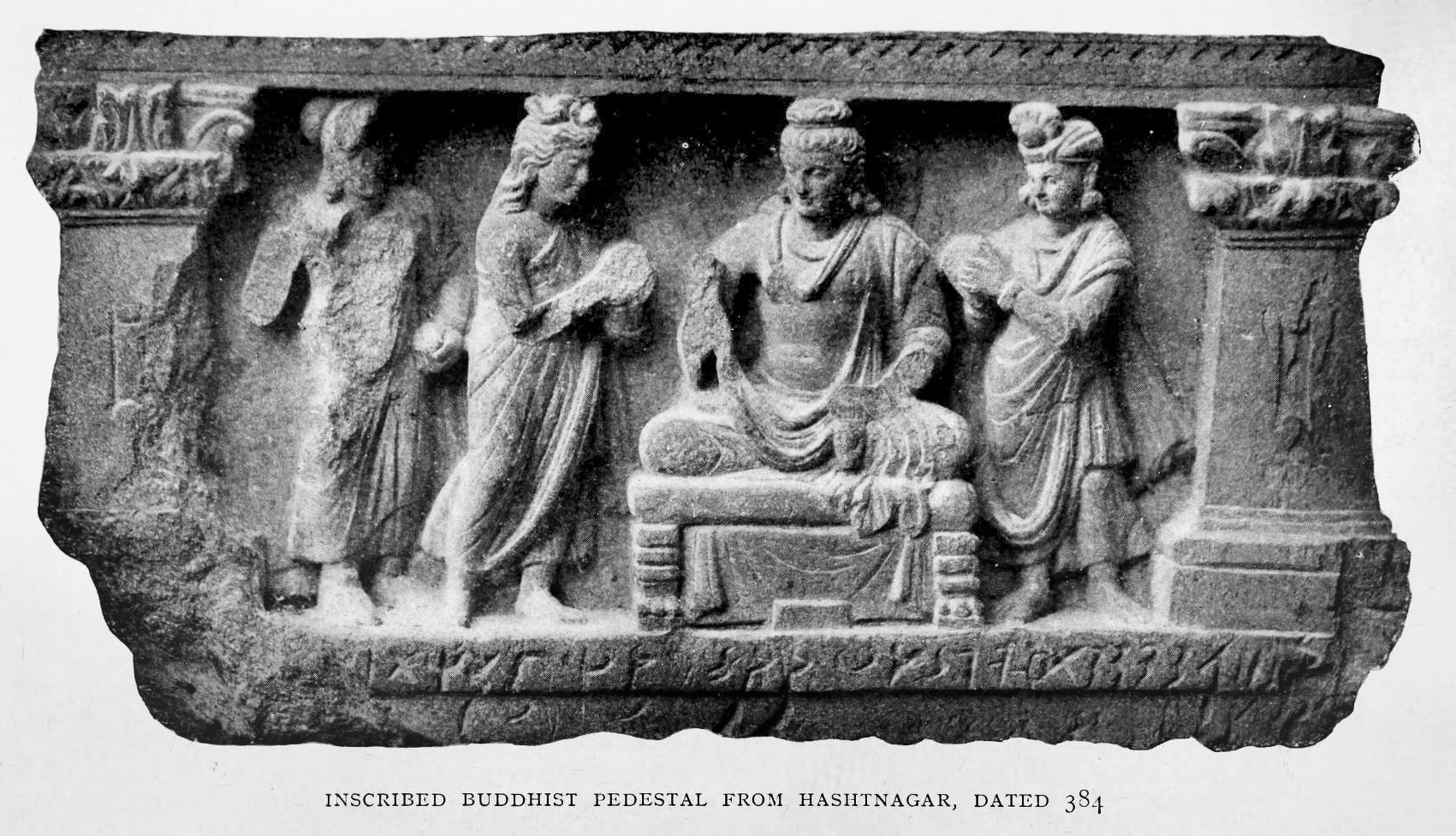
Palatu Dheri is another archaeological site near Charsadda tehsil. A mile from Shar-i-Napursan is a mound which contains the remains of a stupa, which according to Hieun Tsiang, was built by one Deven. Some coins which connect them both to the first century AD have been unearthed. Other finds include the image of the goddess Kalika-devi. Three inscribed jars, which were presented by some laymen to "the Community of the Four Quarters", are now in the Peshawar Museum.
Charsadda
The city of Charsadda originally known as Pushkalavati is mentioned in the Hindu epic story the Ramayana, where Bharata brings this new conquered city to one of his sons, Pushkala.
Bala Hisar of Charsadda
Bala Hisar was excavated twice by the head of the Archaeological Survey of India, Sir John Marshall, in 1902 and by Sir Mortimer Wheeler in 1958. According to the South Asian Archaeology Research Group of Bradford University, Wheeler suggested that Bala Hisar "was founded by the Persians in the sixth century BC as a colony guarding the eastern edge of their empire".
Demographics
|1951 |282,618 |1961 |364,088 |1972 |513,193 |1981 |630,811 |1998 |1,022,364 |2017 |1,610,960
As of the 2023 census, Charsadda district has 263,934 households and a population of 1,835,504. The district has a sex ratio of 107.49 males to 100 females and a literacy rate of 53.94%: 66.55% for males and 40.36% for females. 542,879 (29.58% of the surveyed population) are under 10 years of age. 292,426 (15.93%) live in urban areas. Pashto is the predominant language, spoken by 99.66% of the population.
| Religious | ||||||||||||||||
|---|---|---|---|---|---|---|---|---|---|---|---|---|---|---|---|---|
| group | 1941 | 2017 | 2023 | Pop. | % | Pop. | % | Pop. | % | Total Population | 244,246 | 100% | 1,610,960 | 1,835,136 | 100% | |
| Islam [[File:Star and Crescent.svg | 15px]] | 239,634 | 98.11% | 1,610,087 | 1,830,646 | 99.76% | ||||||||||
| Hinduism [[File:Om.svg | 15px]] | 2,533 | 1.04% | 38 | 41 | ~0% | ||||||||||
| Sikhism [[File:Khanda.svg | 15px]] | 1,940 | 0.79% | 14 | ~0% | |||||||||||
| Christianity [[File:Christian cross.svg | 15px]] | 127 | 0.05% | 518 | 4,392 | 0.24% | ||||||||||
| Others | 12 | 0.01% | 317 | 43 | ~0% | |||||||||||
| Note: 1941 census data is for Charsadda tehsil of erstwhile Peshawar district, which roughly corresponds to contemporary Charsadda district. District and tehsil borders have changed since 1941. |
Administration
The district is administratively subdivided into 3 Tehsils comprising a total of 58 Union Councils:
| Tehsil | Urdu Name | Pashto Name | Area | Pop. | Density | Literacy rate | Union Councils | ||
|---|---|---|---|---|---|---|---|---|---|
| Charsadda Tehsil | {{nq | تحصیل چارسدہ}} | {{script/Arabic | چارسدې تحصیل}} | 445 | 909,438 | 2,043.68 | 58.56% | 34 |
| Shabqadar Tehsil | {{nq | تحصیل شب قدر}} | {{script/Arabic | شب قدر تحصیل}} | 204 | 440,524 | 2,159.43 | 49.65% | 12 |
| Tangi Tehsil | {{nq | تحصیل تنگی}} | {{script/Arabic | تنګي تحصیل}} | 347 | 485,542 | 1,399.26 | 48.85% | 12 |
National Assembly Seats
The district is represented in the National Assembly by two MNAs who represent the following constituencies:
| Constituency | MNA | Party |
|---|---|---|
| NA-24 (Charsadda-I) | Malik Anwar Taj | SIC |
| NA-25 (Charsadda-II) | Mr. Fazal Muhammad Khan | SIC |
Provincial Assembly Seats
The district is represented in the Provincial Assembly by five MPAs who represent the following constituencies:
| Member of Provincial Assembly | Party affiliation | Constituency | Year |
|---|---|---|---|
| Khalid Khan | Pakistan Tehreek-e-Insaf | PK-59 (Charsadda-I) | 2018 |
| Shakeel Bashir Khan | Awami National Party | PK-60 (Charsadda-II) | |
| Sultan Mohammad Khan | Pakistan Tehreek-e-Insaf | PK-61 (Charsadda-III) | |
| Fazle Shakoor Khan | Pakistan Tehreek-e-Insaf | PK-62 (Charsadda-IV) | |
| Mohammad Arif | Pakistan Tehreek-e-Insaf | PK-63 (Charsadda-V) |
Towns and villages
- Sardheri
- Sukar
- Matta Mughal Khel
- Ambhader
- Daulat Pura
- Kangra
References
Bibliography
References
- "Literacy rate, enrolments, and out-of-school population by sex and rural/urban, CENSUS-2023, KPK".
- Beal, Samuel, (ed. & trans.), (1884). [https://ia801607.us.archive.org/1/items/siyukibuddhistre01hsuoft/siyukibuddhistre01hsuoft_bw.pdf Si-yu-ki: Buddhist Records of the Wester World, Volume 1], Author: Huen Tsang, '''p. 112:''' "Outside the eastern gate of the town of Po-lu-sha is a sangharama with about fifty priests, who all study the Great Vehicle. Here is a stupa built by Asoka-raja [...] To the north-east of Po-lu-sha city about 20 li or so we come to Mount Dantaloka. Above a ridge of that mountain is a stupa built by Asoka-raja."
- Province (Pakistan), North-west Frontier. (1931). "N.-W.F. Province Gazetteers".
- Problems of Chronology in Gandharan Art [https://www.carc.ox.ac.uk/PublicFiles/media/Final%20e-version%20Problems%20of%20Chronology%20in%20Gandharan%20Art.pdf p.37]
- Shastri, Hari Prasad, (1952). [https://www.wisdomlib.org/hinduism/book/the-ramayana-of-valmiki/d/doc424876.html "Uttara-kanda, Chapter 101: The slaying of the Gandharvas and the conquest of their Country"], in: ''The Ramayana of Valmiki'': "Bharata, the son of Kaikeyi entered those two opulent and magnificent cities, and there, Bharata established Taksha in Takshashila and Pushkala in Pushkalavata, in the country of the Gandharvas, in the ravishing region of Gandhara."
- "Bradford University – The Bala Hisar of Charsadda".
- "Population by administrative units 1951–1998". [[Pakistan Bureau of Statistics]].
- "7th Population and Housing Census - Detailed Results: Table 1". [[Pakistan Bureau of Statistics]].
- "7th Population and Housing Census - Detailed Results: Table 11".
- "CENSUS OF INDIA, 1941 VOLUME X NORTH-WEST FRONTIER PROVINCE".
- "Pakistan Census 2017 District-Wise Tables: Charsadda".
- "Pakistan Census 2023". [[Pakistan Bureau of Statistics]].
- link. (March 22, 2008)
- "TABLE 1 : AREA, POPULATION BY SEX, SEX RATIO, POPULATION DENSITY, URBAN POPULATION, HOUSEHOLD SIZE AND ANNUAL GROWTH RATE, CENSUS-2023, KPK".
- "LITERACY RATE, ENROLMENT AND OUT OF SCHOOL POPULATION BY SEX AND RURAL/URBAN, CENSUS-2023, KPK".
- [https://www.na.gov.pk/en/all_members.php Members of the National Assembly of Pakistan]
- [http://www.pakp.gov.pk/2013/members-directory/by-districts/ Members of the Khyber Pakhtunkhwa Assembly]
This article was imported from Wikipedia and is available under the Creative Commons Attribution-ShareAlike 4.0 License. Content has been adapted to SurfDoc format. Original contributors can be found on the article history page.
Ask Mako anything about Charsadda District, Pakistan — get instant answers, deeper analysis, and related topics.
Research with MakoFree with your Surf account
Create a free account to save articles, ask Mako questions, and organize your research.
Sign up freeThis content may have been generated or modified by AI. CloudSurf Software LLC is not responsible for the accuracy, completeness, or reliability of AI-generated content. Always verify important information from primary sources.
Report