From Surf Wiki (app.surf) — the open knowledge base
Cedar City, Utah
City in the United States
.png)
City in the United States
| Field | Value | ||
|---|---|---|---|
| name | Cedar City, Utah | ||
| settlement_type | City | ||
| nickname | Festival City USA | ||
| motto | |||
| image_skyline | Cedar City Utah 02.jpgborder | ||
| image_caption | Main Street in September 2005 | ||
| <!-- Commented out: | image_flag | Flag of Cedar City, Utah.png -- | image_flag = Flag of Cedar City, Iron County, Utah.png |
| flag_size | 125px | ||
| mapframe | yes | ||
| mapframe-zoom | 11 | ||
| mapframe-point | none | ||
| pushpin_map | Utah#USA | ||
| pushpin_map_caption | Location within Utah##Location within the United States | ||
| pushpin_relief | 1 | ||
| pushpin_label | Cedar City | ||
| subdivision_type | Country | ||
| subdivision_name | |||
| subdivision_type1 | State | ||
| subdivision_name1 | Utah | ||
| subdivision_type2 | County | ||
| subdivision_name2 | Iron | ||
| leader_title | Mayor | ||
| established_title | Founded | ||
| established_date | November 11, 1851 | ||
| established_title1 | Incorporated | ||
| established_date1 | February 18, 1868 | ||
| named_for | Juniper ("cedar") trees | ||
| <!-- Area --> | unit_pref | Imperial | |
| area_footnotes | |||
| area_total_km2 | 93.10 | ||
| area_land_km2 | 92.89 | ||
| area_water_km2 | 0.21 | ||
| area_total_sq_mi | 35.94 | ||
| area_land_sq_mi | 35.86 | ||
| area_water_sq_mi | 0.08 | ||
| <!-- Population --> | population_as_of | 2020 | |
| population_total | 35235 | ||
| population_density_km2 | 379.32 | ||
| population_density_sq_mi | 982.57 | ||
| <!-- General information --> | timezone | Mountain (MST) | |
| utc_offset | −7 | ||
| timezone_DST | MDT | ||
| utc_offset_DST | −6 | ||
| elevation_footnotes | |||
| elevation_ft | 5670 | ||
| coordinates | |||
| postal_code_type | ZIP codes | ||
| postal_code | 84720-84721 | ||
| area_code | 435 | ||
| blank_name | FIPS code | ||
| blank_info | 49-11320 | ||
| blank1_name | GNIS feature ID | ||
| blank1_info | 2409415 | ||
| website |
| mapframe-zoom = 11 | mapframe-point = none
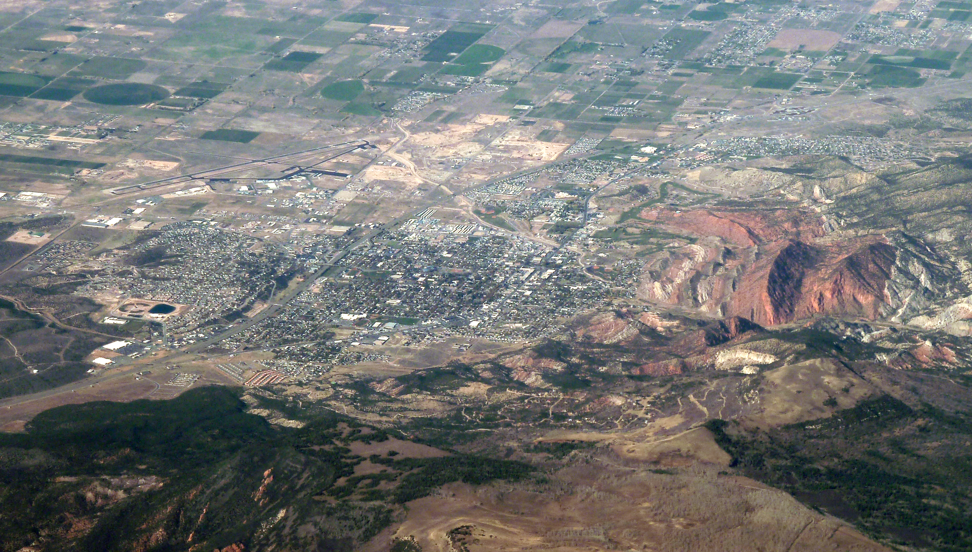
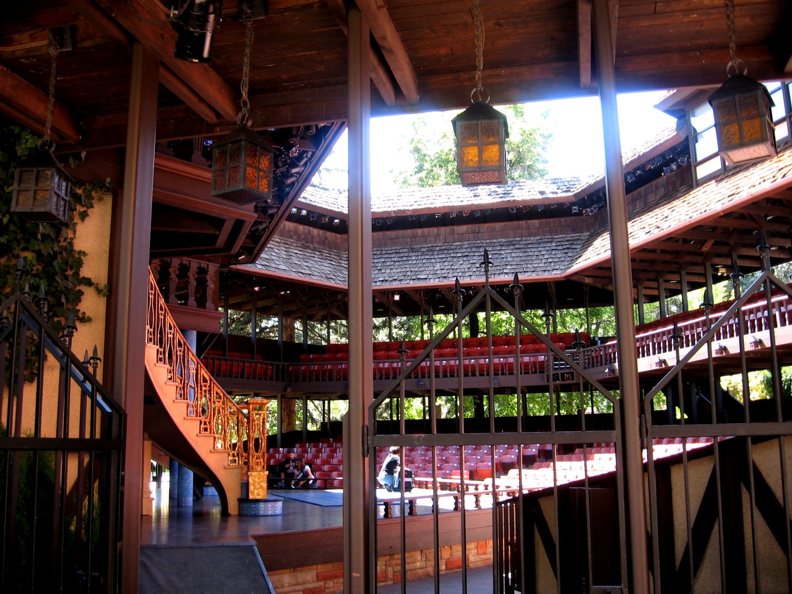
Cedar City is the largest city in Iron County, Utah, United States. Located 250 mi south of Salt Lake City, it is 170 mi north of Las Vegas on Interstate 15. Southern Utah University is located in Cedar City. It is the home of the Utah Shakespeare Festival, the Utah Summer Games, the Simon Fest Theatre Co., and other events. As of the 2020 census the city had a population of 35,235, up from 28,857 in the 2010 census.
History
The presence of prehistoric people in the Cedar City area is revealed by rock art found in Parowan Gap to the north and Fremont sites dated to A.D. 1000 and 1300. Ancestors of the present-day Southern Paiute people met the Domínguez–Escalante expedition in this area in 1776. Fifty years later, in 1826, mountain man and fur trader Jedediah Smith traveled through the area, exploring a route from Utah to California.
Cedar City was originally settled in late 1851 by Mormon pioneers originating from Parowan, Utah, who were sent to build an iron works. The site, known as "Fort Cedar" or "Cedar City," was equidistant from vast iron deposits 10 mi west and coal resources 10 mi east up Cedar Canyon, but was named after the abundant local trees (which are not cedars but junipers). Two companies of men led by Henry Lunt reached the fort site in a blizzard on November 11, 1851, making that date the official founding. In 1855, a new site, closer to the iron works and out of the flood plain of Coal Creek, was established at the suggestion of Brigham Young. A furnace operated from September 1852 for three years, producing about 25 tons of pig iron, using iron ore deposits located in the Iron Mountain District.

Cedar City was incorporated on February 18, 1868.
The ironworks closed in 1858, though mining continued in the area until the 1980s. The completion of a railroad connection to Cedar City in 1923 established the area as a tourism gateway to nearby Bryce Canyon National Park, Zion National Park, Grand Canyon National Park, and Cedar Breaks National Monument. Cedar City continues to be a center of tourism, commercial development, education, and the arts in southwestern Utah.
The city has shared in the rapid growth of much of southwestern Utah since the late 1980s.
On December 10, 2017, the Church of Jesus Christ of Latter-day Saints dedicated its Cedar City Utah Temple.
Geography

Cedar City is located in the southeast Great Basin and is approximately 20 mi north of the northeastern edge of the Mojave Desert. Its elevation of 5846 ft gives it a somewhat cooler climate compared to the nearby St. George region, though it retains cultural ties to the city. For example, the two share a daily newspaper.
According to the United States Census Bureau, the city has a total area of 20.1 sqmi, all land. In some of the older neighborhoods in the city, an irrigation system is utilized by many residents for their lawns and gardens, as "water is diverted from a natural stream (Coal Creek) into a series of canals and ditches for residential flood irrigation."
Climate
The city is located on the western edge of the Markagunt Plateau, in a high desert valley, Cedar Valley, with no ocean drainage. The climate is the typical semi-arid climate (BSk) of the Mountain West, though snowfall can be quite heavy, reaching a historical maximum of 36.9 in in January 1949.
|Jan record high F = 70 |Feb record high F = 73 |Mar record high F = 81 |Apr record high F = 86 |May record high F = 96 |Jun record high F = 102 |Jul record high F = 105 |Aug record high F = 101 |Sep record high F = 99 |Oct record high F = 89 |Nov record high F = 76 |Dec record high F = 68
|Jan avg record high F = 56.6 |Feb avg record high F = 61.8 |Mar avg record high F = 70.5 |Apr avg record high F = 77.4 |May avg record high F = 86.2 |Jun avg record high F = 95.1 |Jul avg record high F = 98.9 |Aug avg record high F = 95.7 |Sep avg record high F = 90.2 |Oct avg record high F = 80.8 |Nov avg record high F = 69.0 |Dec avg record high F = 58.2 |year avg record high F = 99.3
|Jan avg record low F = -2.1 |Feb avg record low F = 3.6 |Mar avg record low F = 13.0 |Apr avg record low F = 19.4 |May avg record low F = 26.5 |Jun avg record low F = 35.3 |Jul avg record low F = 47.5 |Aug avg record low F = 46.2 |Sep avg record low F = 32.0 |Oct avg record low F = 19.7 |Nov avg record low F = 6.5 |Dec avg record low F = -2.5 |year avg record low F = -7.5
|Jan record low F = -26 |Feb record low F = -24 |Mar record low F = -1 |Apr record low F = 6 |May record low F = 16 |Jun record low F = 27 |Jul record low F = 40 |Aug record low F = 35 |Sep record low F = 23 |Oct record low F = -7 |Nov record low F = -12 |Dec record low F = -23
|Jan snow depth inch = |Feb snow depth inch = |Mar snow depth inch = |Apr snow depth inch = |May snow depth inch = |Jun snow depth inch = |Jul snow depth inch = |Aug snow depth inch = |Sep snow depth inch = |Oct snow depth inch = |Nov snow depth inch = |Dec snow depth inch = |year snow depth inch =
|access-date = October 3, 2024 |access-date = October 3, 2024 |access-date = October 3, 2024
Demographics
As of the census of 2000, there were 20,527 people, 6,486 households, and 4,682 families residing in the city. The population density was 1,021.8 /mi2. There were 7,109 housing units at an average density of 353.9 /mi2. The racial makeup of the city was 92.06% White, 2.53% African American, 1.11% Native American, 0.47% Asian, 0.33% Pacific Islander, 1.65% from other races, and 1.86% from two or more races. Hispanic or Latino of any race were 4.14% of the population.
There were 6,486 households, out of which 39.0% had children under the age of 18 living with them, 59.8% were married couples living together, 9.1% had a female householder with no husband present, and 27.8% were non-families. 16.3% of all households were made up of individuals, and 5.8% had someone living alone who was 65 years of age or older. The average household size was 3.07 and the average family size was 3.37.
In the city, the population was spread out, with 28.2% under the age of 18, 27.4% from 18 to 24, 22.6% from 25 to 44, 14.0% from 45 to 64, and 7.8% who were 65 years of age or older. The median age was 23 years. For every 100 females, there were 95.6 males. For every 100 females age 18 and over, there were 91.0 males.
The median income for a household in the city was $32,403, and the median income for a family was $37,509. Males had a median income of $31,192 versus $19,601 for females. The per capita income for the city was $14,057. About 14.5% of the families and 22.1% of the population were below the poverty line, including 20.2% of those under the age of 18 and 4.2% of those 65 and older.
Education
Cedar City is served by the Iron County School District.
Cedar City is home of two High Schools, Cedar High School and Canyon View High School.
Cedar City is home to Southern Utah University.
Economy
The economy is mostly centered on a small manufacturing hub, tourism, Southern Utah University, and home construction. The largest employers in Cedar City (2019 data) are listed below.
| Walmart | 250-499 |
|---|
Transportation

Interstate 15 connects the city with St. George (50 miles) and Las Vegas (170 miles) to the southwest, and to Interstate 70 (75 miles) and Salt Lake City (250 miles) to the north. State roads connect Cedar City with Panaca, Nevada, near US 93 (80 miles); and to Kanab, via US-89 (80 miles). Similar to St. George, the city enjoys an excellent location on the West's regional transportation network. Los Angeles is 439 mi southwest and San Diego is 500 mi southwest on Interstate 15, Phoenix is 465 mi south via Interstate 15 and US-93, and Denver is 580 mi northeast via Interstates 15 and 70.
A branch line of the Union Pacific Railroad serves customers on the city's western outskirts. The branch connects to the railway's main line at Lund.
Cedar City Regional Airport offers flights via Delta Connection.
Cedar City is served by a local bus system.
Notable people

- Christine Cavanaugh (1963–2014), voice actress in Dexter's Laboratory and Rugrats
- Lamar Clark, boxer
- Ally Condie, author of the best-selling Matched series and the book Atlantia; born in Cedar City
- Melvin Dummar (1944–2018), claimed to be an heir of Howard Hughes; born in Cedar City
- Riley Griffiths, teenage actor best known for his role in the 2011 film Super 8; born in Cedar City
- Mike Leavitt, former governor of Utah, former administrator of the United States Environmental Protection Agency, and former secretary of the U.S. Department of Health and Human Services; born and educated in Cedar City
- Celeste Maloy, U.S. representative for Utah
- L. E. Modesitt Jr., science fiction and fantasy author; lives in Cedar City
- Doug Murdoch, professor at Southern Utah University Educator born in Florida
- Del Parson, artist most known for his depictions of Jesus Christ; lives in Cedar City
- Helen Foster Snow, journalist who reported from China in the 1930s under the name "Nym Wales"
- Mitch Talbot, professional baseball player in Major League Baseball as a pitcher; born in Cedar City
References
- Seegmiller, Janet Burton. A History of Iron County: Community Above Self. Salt Lake City, UT: Iron County Commission and Utah State Historical Society, 1997.
References
- "Cedar City: Festival City USA". City of Cedar City.
- "2019 U.S. Gazetteer Files". United States Census Bureau.
- "QuickFacts Cedar City city, Utah". United States Census Bureau.
- "U.S. Census website". [[United States Census Bureau]].
- {{GNIS. 2409415
- Shirts, Morris A.. (1994). "Utah History Encyclopedia". University of Utah Press.
- {{Cite gnis. 1439835. Coal Creek
- (1968). "Iron Ore Deposits of the Iron Springs District, Southwestern Utah, in Ore deposits of the United States, 1933-1967". The American Institute of Mining, Metallurgical, and Petroleum Engineers, Inc..
- Coral Gardner and Don Long (2015). "Changes in Water Chemistry in Cedar City Irrigation System." Utah Conference on Undergraduate Research (2015 – UCUR Abstracts). http://ucur.org/abstracts/?p=2029
- [http://www.wrcc.dri.edu/cgi-bin/cliMAIN.pl?utceda Monthly Snowfall Totals for CEDAR CITY FAA AIRPORT, UTAH (421267)]
- "Census of Population and Housing". Census.gov.
- "Largest Employers | Cedar City, UT - Official Website".
- "Transportation | Cedar City, UT - Official Website".
- "MALOY, Celeste".
This article was imported from Wikipedia and is available under the Creative Commons Attribution-ShareAlike 4.0 License. Content has been adapted to SurfDoc format. Original contributors can be found on the article history page.
Ask Mako anything about Cedar City, Utah — get instant answers, deeper analysis, and related topics.
Research with MakoFree with your Surf account
Create a free account to save articles, ask Mako questions, and organize your research.
Sign up freeThis content may have been generated or modified by AI. CloudSurf Software LLC is not responsible for the accuracy, completeness, or reliability of AI-generated content. Always verify important information from primary sources.
Report