From Surf Wiki (app.surf) — the open knowledge base
Cay Sal Bank
| Field | Value |
|---|---|
| name | Cay Sal Bank |
| Placer de los Roques | |
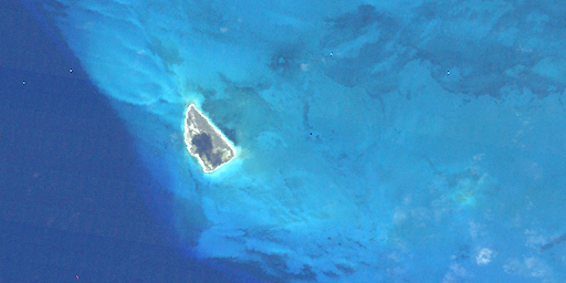
| image_skyline | CAYSAL1.png |
| image_caption | Cay Sal Bank overview map |
| settlement_type | Carbonate platform |
| image_map | Cuba-Florida_map.jpg |
| map_caption | Cay Sal Bank south of Florida and north of Cuba |
| subdivision_type | Country |
| subdivision_name | The Bahamas |
| subdivision_type1 | Region |
| subdivision_name1 | Bahama Banks |
| subdivision_type2 | District |
| subdivision_name2 | Bimini |
| subdivision_type3 | Number of islands |
| subdivision_name3 | 96 |
| subdivision_type4 | Total land area |
| subdivision_name4 | 14.87 km2 |
| established_title | |
| unit_pref | Metric |
| area_total_km2 | 5226.73 |
| population_density_km2 | auto |
| demographics_type1 | Languages |
| demographics1_title1 | Official |
| demographics1_info1 | English |
| timezone1 | EST |
| utc_offset1 | −5 |
Placer de los Roques
_p0216_BAHAMAS,_CAY_SAL_LIGHTHOUSE.jpg)

Cay Sal Bank () is the third largest (after Great Bahama Bank and Little Bahama Bank) and the westernmost of the Bahama Banks. It is located between 23º27'N - 24º10'N and 079º25'W – 080º35'W, and is found between Cuba, the Great Bahama Bank, and the Florida Keys. In a geographical sense, it lies closer to Cuba than to The Bahamas proper, lying 50 km away from Cuba across the Nicholas Channel. It is separated by the Santaren Channel from the Great Bahama Bank, the western rim of which is 50 km to the east, and is separated from the Florida Keys by the Straits of Florida, lying 100 km to the south of Key Largo.
Administratively, the bank and its islands are part of Bimini district of The Bahamas, the main islands of which are 150 km to the north. The closest point of any other named Bahamian land to the bank is Orange Cay (), the southernmost island of the Bimini Chain. The distance between Orange Cay and the nearest dry land of Cay Sal Bank, the Dog Rocks, is 120 km. The westernmost tip of Andros is the second closest point of land, approximately 145 km east of Cay Sal Bank.
Geography
Cay Sal Bank is an atoll of roughly triangular shape, with a base along the south rim of 105 km, and a width of 66 km north-south. With a surface of 5,226.73 km² it is one of the largest atolls of the world. Among the atolls with some land area (i.e. disregarding totally submerged atoll structures), Cay Sal Bank is second only to Great Chagos Bank. The lagoonal surface has a depth of 9 to. The individual islands (i.e. islets or cays) are 96 in number.
Cay Sal Bank has numerous islets along its rim, except along the south side facing Nicholas Channel, where it has only rocky coral heads. It has a total of 96 islands, islets and rocks awash, with a total land area of 14.87 km².
Features
The islands, rocks and reefs along the rim of the atoll are listed clockwise from southwest to southeast. There are also a number of smaller, unnamed cays or rocks. Some of the historical Spanish language names of the features of the bank were replaced by English names when the Bahamas became a British Crown colony in the 18th century.
- Lavenderas Rocks (), . It is a submerged reef to the ESE of Cay Sal Island.
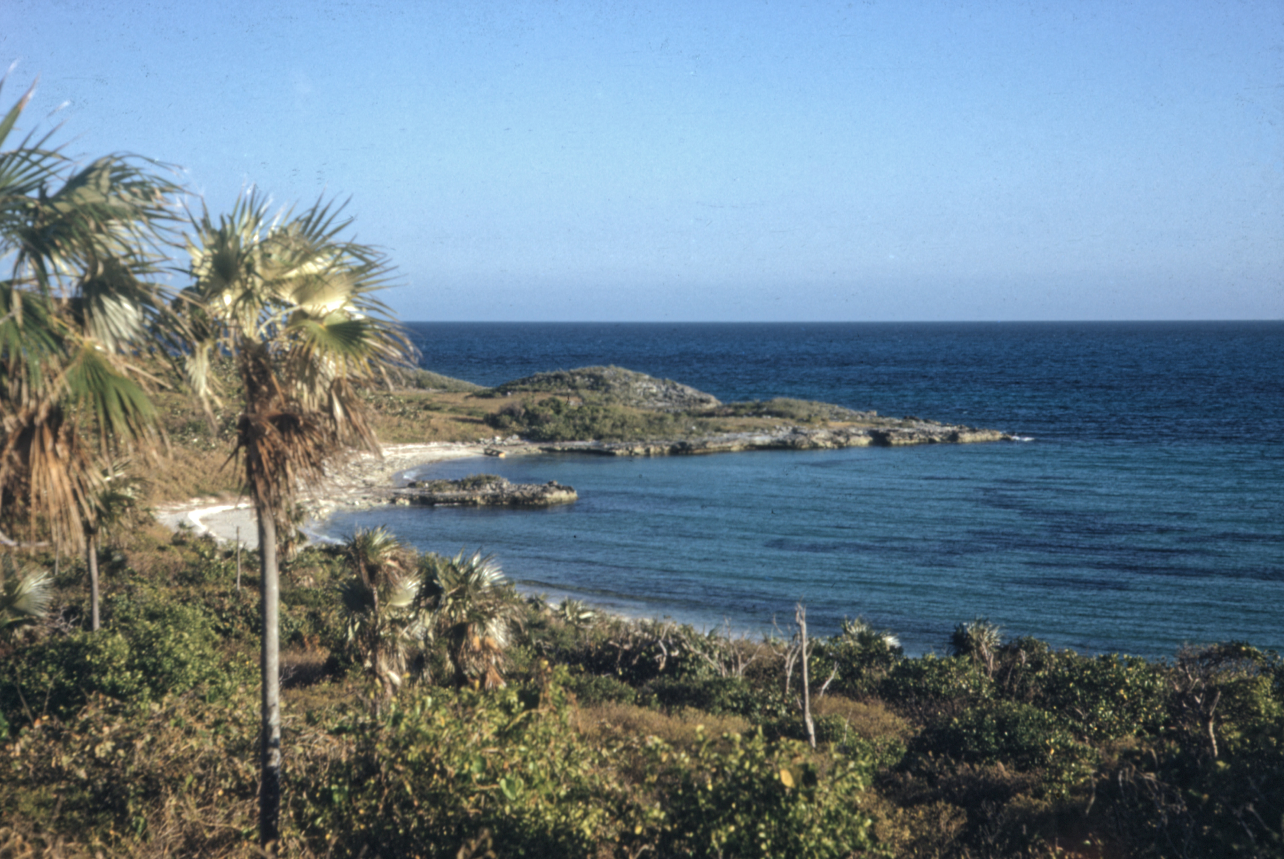
- Cay Sal (), . Cay Sal, the main island in the southwest, is 1.6 km, 1.22 km2 in area, and is no longer inhabited. In its interior is a large salt pond commonly replenished by heavy wind-driven seas that broach the islet along its southwest side. It is covered with stunted palm trees and marked by several dilapidated buildings standing on its west side. This cay gives the name to the whole bank in the English language.
- Rompidas Ledge, (submerged). Rompidas Ledge is a submerged coral head 3 km northwest of Cay Sal, about 1 km2 in extension and only 6 m deep. The cargo ship M/V Cork ran aground there in 1983, and position is marked by its wreck.
- The compact group formed by Elbow Cays, Crenula Cay, Double Headed Shot Cays, Water Cays and Marion Rock is known in Spanish as Los Roques. These northwestern cays gave their name to the whole bank in the Spanish language.
- Elbow Cays, are the westernmost group, running southwest to northeast along the Straits of Florida. The southernmost cays of the group consist of unnamed islets and rocks. Northeast of these are South Elbow Cay (the westernmost named cay of Cay Sal Bank) and North Elbow Cay, sometimes known just as Elbow Cay (). North Elbow Cay, which is the largest and highest of the cays, is marked by a disused conical stone lighthouse, which is 17.7 m high.
- Crenula Cay
- Double Headed Shot Cays, . The Double Headed Shot Cays are a group of elongated cays that extend northeastward from the Elbow Cays, incorporating the Water Cays and all islets and reefs up to the Deadman Cays. They are in a position on the northwest side of Cay Sal Bank where the Florida Current, in its course east and north through the Straits of Florida, usually sets close offshore at full strength.
- Water Cays () (West Water Cay and East Water Cay), . These cays were mentioned by Alexander Von Humboldt.
- Marion Rock, (submerged). Located of the northern coast of the 'Los Roques' reef.
- Deadman Cays,
- Muertos Cays (), , located between the 'Los Roques' and the Dog Rocks.
- Dog Rocks, (), the northeasternmost island/reef group.
- Damas Cays (), Located on the approximate centre of the eastern side of the bank.
- Dangerous Shoals or 'Dangerous Rocks' ()
- North Dangerous Shoals,
- South Dangerous Shoal,
- Bellows Cay,
- Anguilla Cays, . Anguilla Cays, near the southeast extremity of Cay Sal Bank, consist of several elongated, scrub-covered, sandy islands which are swampy near their southern end, and are marked here and there by stunted palm trees. The northern end of Anguilla Cays is marked by a beacon, 5 m high. Anguilla Cay is the name of the northern and second largest of the Anguilla Cays. Cotton Cay (sometimes just South Anguilla Cay) is the largest and southernmost of the Anguilla Cays. Between the two is the much smaller Middle Cay. In early 2021 three Cubans were stranded on one of the Anguilla Cays for 33 days after their boat was capsized by a storm. The three survived on coconuts, conches and rats for more than a month until their rescue by the US Coast Guard on February 9, after being spotted waving a makeshift flag by a routine patrol flight the day before.
History
Spanish navigators visited the area plotting it for the first time on a map in 1511 as Los Roques and it was mapped by subsequent cartographers often with its adjacent Placer. The atoll was subsequently claimed for the Spanish crown by Juan Ponce de León. The bank was under the Spanish rule for about two centuries until 1718 when the Bahamas became a Crown colony of the British Empire. In 1825 Alexander Von Humboldt highlighted that the 'Salt Cays' were a danger for navigation, but that the waters had been previously well charted by Francisco de Seixas in 1692:
But such precise coordinates, so important for ships wishing to avoid Florida's sand bars in leaving the Channel and the Placer de los Roques (Salt Keys), can already be found in Captain Francisco de Seixas y Lobera's old unpublished maps from 1692.
Cay Sal Lighthouse, a tall stone lighthouse was built by the British on the island of North Elbow Cay in 1839 along with some small buildings. It marked the southern entrance to the Florida Straits from the Gulf of Mexico and was active until the 1940s. The abandoned lighthouse was briefly reactivated during the 1970s, when the Royal Bahamas Defence Force set up a post on nearby Cay Sal Island to watch for drug smugglers. The small outpost on Cay Sal island included the only airstrip on Cay Sal Bank and was kept from the 1960s to late 1970s.
Currently Cay Sal Bank is known for its many scuba diving spots, but good weather is needed in order to approach the reefs without danger.
Cartography
Ancient maps and nautical charts show Los Roques or Elbow Cays with or without the Placer or Pracel to the east. In the older maps the size of the cays and their adjacent bank was often exaggerated and merged with the Great Bahama Bank.
| [[File:Los Roques-1696 Danckerts Map of Florida, the West Indies, and the Caribbean - Geographicus - WestIndies-dankerts-1696.jpg | thumb | 260px | Los Roques with the Placer in a 1696 Danckerts map.]] | [[File:Le Pracel - 1708 De L'Isle Map of North America (Covens and Mortier ed.) - Geographicus - AmeriqueSeptentrionale-covensmortier-1708.jpg | thumb | 255px | "Le Pracel" in a 1708 De L'Isle map.]] | [[File:Placer de los Roques-1854.jpg | thumb | 280px | 1854 Spanish map of the Placer de los Roques (Banco de Cayo Sal).]] |
|---|
References
References
- [https://books.google.com/books?id=ZQkvAAAAYAAJ&pg=PA286 ''Derrotero de las islas Antillas, de las costas Tierra-Firme, y las del Seno Mejicano'', Dirección de Hidrografía, España, Madrid, Imprenta Nacional, 1837. p. 24 and p. 278]
- [http://www.qslnet.de/member/na219/QTH.htm Cay Sal Bank]
- [http://tierra.tutiempo.net/Las-Bahamas/Lavanderas-Rocks-BF001196.html Las Bahamas : Recursos Orográficos]
- [https://books.google.com/books?id=SgoZAAAAYAAJ&pg=PA257 ''Derrotero de las islas Antillas, de las costas Tierra-Firme, y las del Seno Mejicano'', Dirección de Hidrografía, España, Madrid, Imprenta Nacional, 1837. p. 265]
- NGA Navigational Chart #27087, ''Cay Sal Bank''. 3rd Edition, corrected through Mar-01.
- NOAA Navigational Chart #11013, ''Atlantic Coast: Straits of Florida and Approaches''. 48th Edition, corrected though Feb-12. Available as a NOAA Raster Navigational Chart at the [http://www.nauticalcharts.noaa.gov/mcd/Raster/download_agreement.htm NOAA Office of Coast Survey RNC Downloads website].
- Alexander Von Humboldt, ''Political Essay on the Island of Cuba: A Critical Edition'', ed. and transl. by Vera M. Kutzinski and Ottmar Ette, University of Chicago Press, p. 61
- Fazio, Marie. (2021-02-10). "3 People Stranded on Uninhabited Island Are Rescued After 33 Days". The New York Times.
- (2021-02-10). "Three Cubans survive on coconuts for 33 days on uninhabited island". BBC News.
- Alexander Von Humboldt, ''Political Essay on the Island of Cuba: A Critical Edition'', ed. and transl. by Vera M. Kutzinski and Ottmar Ette, University of Chicago Press, p. 7
- [http://www.lighthousedigest.com/Digest/StoryPage.cfm?StoryKey=1921 Cay Sal Bank Lighthouse: A Stately Ruin]
- {{Cite rowlett. bhs
- [http://www.qslnet.de/member/na219/QTH.htm IOTA-DXpedition to Cay Sal Bank NA219, Bahamas]
This article was imported from Wikipedia and is available under the Creative Commons Attribution-ShareAlike 4.0 License. Content has been adapted to SurfDoc format. Original contributors can be found on the article history page.
Ask Mako anything about Cay Sal Bank — get instant answers, deeper analysis, and related topics.
Research with MakoFree with your Surf account
Create a free account to save articles, ask Mako questions, and organize your research.
Sign up freeThis content may have been generated or modified by AI. CloudSurf Software LLC is not responsible for the accuracy, completeness, or reliability of AI-generated content. Always verify important information from primary sources.
Report