From Surf Wiki (app.surf) — the open knowledge base
Carver County, Minnesota
County in Minnesota, United States
County in Minnesota, United States
| Field | Value |
|---|---|
| county | Carver County |
| state | Minnesota |
| ex image | Carver County Justice Center, Minnesota (34480327800).jpg |
| ex image size | 220px |
| ex image cap | Carver County Sheriff's Office and Justice Center in Chaska, Minnesota |
| founded date | February 20 |
| founded year | 1855 |
| seat wl | Chaska |
| largest city | Chaska |
| area_total_sq_mi | 376 |
| area_land_sq_mi | 354 |
| area_water_sq_mi | 22 |
| area percentage | 5.8% |
| population_as_of | 2020 |
| population_total | 106922 |
| pop_est_as_of | 2024 |
| population_est | 112628 |
| density_sq_mi | 302 |
| time zone | Central |
| website | www.co.carver.mn.us |
| named for | Jonathan Carver |
| district | 6th |
Carver County is a county in the U.S. state of Minnesota. As of the 2020 census, the population was 106,922. Its county seat is Chaska. Carver County is named for explorer Jonathan Carver, who in 1766–67, traveled from Boston to the Minnesota River and wintered among the Sioux near the site of New Ulm. Carver County is part of the Minneapolis-St. Paul-Bloomington, MN-WI Metropolitan Statistical Area.
Statistics
In 2017, Carver County was ranked by the Robert Wood Johnson Foundation as the healthiest county in the State of Minnesota for the fifth year in a row. The foundation explained health outcomes represent “how healthy counties are within the state,” whereas health factors represent “an estimate of the future health of counties as compared with other counties within a state,” based on health behaviors, clinical care, and other environmental factors. Carver County continued to rank as the number one healthiest county throughout the state for 2018, 2019, and 2020.
In 2018, Carver County was ranked as the #1 "Happiest Place in America" according to a study conducted by the data firm Smart Asset. Carver County was one of three United States counties to receive a top 5 ranking for the third straight year. The other two counties were Loudoun and Fairfax counties in Virginia. The study compared counties across the country using the following eight factors: unemployment rate, poverty rate, affordability ratio, marriage rate, divorce rate, bankruptcy rate, life expectancy, and physical activity rate. In particular, Carver County scored well thanks to strong economic conditions with an unemployment rate of only 3.1% and a poverty rate of only 4.1%. Additionally, according to the data, 62% of residents were married and only 8% divorced. In each of those metrics, Carver ranked in the top 40 in the country.
Geography
The Minnesota River flows east-northeasterly along the county's southern border. The South Fork of the Crow River flows northeasterly through the upper western and central portions of the county. Carver Creek flows southeasterly from the county's central area, discharging into the Minnesota at the county's southern border. The terrain consists of low rolling hills, dotted with lakes in the eastern portion. The area is devoted to agriculture.
The county has a total area of 376 sqmi, of which 354 sqmi is land and 22 sqmi (5.8%) is water. It is Minnesota's second-smallest county by land area and third-smallest by total area.
Carver is one of seven southern Minnesota counties with no forest soils; only prairie ecosystems of savannas and prairies can be found in Carver County. It is also one of 17 Minnesota counties where savanna soils dominate.
Lakes
Carver County is home to seven lakes of 235 acres or larger. The largest is Lake Waconia, Minnesota's 73rd largest lake and the Twin Cities' second largest lake, with an area of 2,996 acres.[[File:2009-0713-Waconia-LakeWaconia.jpg|thumb|250px|right|Lake Waconia]]
| Township | Lakes |
|---|---|
| Benton Township | Barlous Lake, Benton Lake, Maria Lake, Meuwissen Lake, Myers Lake, Rice Lake, Winkler Lake |
| Camden Township | Berliner Lake, Eagle Lake, Smith Lake |
| Dahlgren Township | Aue Lake |
| Hancock Township | Assumption Lake, Gaystock Lake, Maria Lake, Miller Lake, |
| Hollywood Township | Lippert Lake |
| Laketown Township | Carl Krey Lake, Lake Auburn, Lake Virginia, Lake Waconia, Lake Zumbra, Lunsten Lake, Marsh Lake, Parley Lake, Piersons Lake, Reitz Lake, Schutz Lake, Stieger Lake, Sunny Lake, Turbid Lake, Wasserman Lake, Lake Bavaria |
| San Francisco Township | Hallquist Lake, Kelly Lake, Long Lake, Scott Lake, |
| Waconia Township | Burandt Lake, Donders Lake, Goose Lake, Hydes Lake, Lake Minnewashta, Lake Patterson, Lake Waconia, Rutz Lake, Swan Lake |
| Watertown Township | Buck Lake, Goose Lake, Lippert Lake, Mud Lake, Oak Lake, Swede Lake |
| Young America Township | Barnes Lake, Brand Lake, Braunworth Lake, Tiger Lake, Young America Lake |
Major highways
- [[Image:US 212 (MN).svg|23px]] U.S. Highway 212
- [[Image:MN-5.svg|20px]] Minnesota State Highway 5
- [[Image:MN-7.svg|20px]] Minnesota State Highway 7
- [[Image:MN-25.svg|20px]] Minnesota State Highway 25
- [[Image:MN-41.svg|20px]] Minnesota State Highway 41
- [[Image:MN-284.svg|20px]] Minnesota State Highway 284
- Carver County Road 10
- Carver County Road 11
- Carver County Road 33
- Other county roads

Adjacent counties
- Wright County – north
- Hennepin County – northeast
- Scott County – southeast
- Sibley County – southwest
- McLeod County – west
Protected areas
- Assumption State Wildlife Management Area
- Carver Park Preserve
- Gravel Pit State Wildlife Management Area
- Lake Minnewashta Regional Park
- Minnesota Landscape Arboretum
- Minnesota Valley National Wildlife Refuge (part)
- Minnesota Valley State Recreation Area (part)
- Waconia State Wildlife Management Area
Climate and weather
In recent years, average temperatures in the county seat of Chaska have ranged from a low of 4 °F in January to a high of 81 °F in July, although a record low of -41 °F was recorded in January 1970 and a record high of 105 °F was recorded in July 1988. Average monthly precipitation ranged from 0.66 in in February to 5.05 in in August.
|Chaska, Minnesota |4|22|0.73 |9|28|0.66 |21|40|1.73 |34|57|2.53 |46|69|3.69 |56|78|4.64 |60|81|3.49 |58|78|5.05 |49|71|3.41 |36|58|2.47 |23|41|1.64 |8|26|0.95
Demographics
|align-fn=center 1790–1960 1900–1990 1990–2000 2010–2020
2020 census
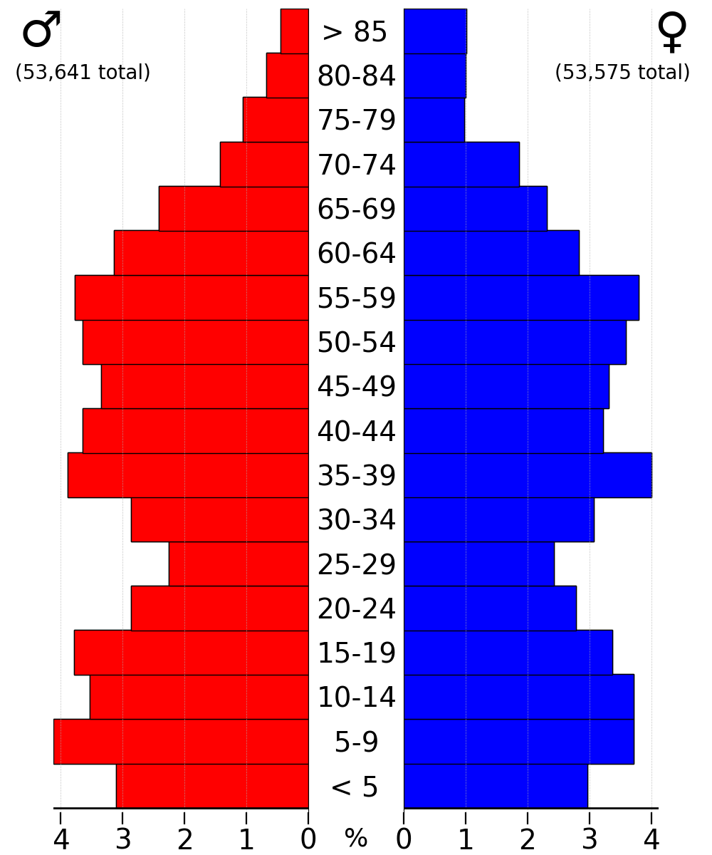
As of the 2020 United States census, the county had a population of 106,922. The median age was 38.6 years. 27.2% of residents were under the age of 18 and 12.8% of residents were 65 years of age or older. For every 100 females there were 97.6 males, and for every 100 females age 18 and over there were 95.3 males age 18 and over.
The racial makeup of the county was 86.5% White, 2.1% Black or African American, 0.3% American Indian and Alaska Native, 3.4% Asian,
75.3% of residents lived in urban areas, while 24.7% lived in rural areas.
There were 38,863 households in the county, of which 38.3% had children under the age of 18 living in them. Of all households, 62.6% were married-couple households, 12.7% were households with a male householder and no spouse or partner present, and 19.4% were households with a female householder and no spouse or partner present. About 20.8% of all households were made up of individuals and 8.6% had someone living alone who was 65 years of age or older.
There were 40,380 housing units, of which 3.8% were vacant. Among occupied housing units, 81.1% were owner-occupied and 18.9% were renter-occupied. The homeowner vacancy rate was 1.0% and the rental vacancy rate was 5.4%.
Racial and ethnic composition
| Race / Ethnicity | title=P2 HISPANIC OR LATINO, AND NOT HISPANIC OR LATINO BY RACE - 2010: DEC Redistricting Data (PL 94-171) - Carver County, Minnesota | url=https://data.census.gov/cedsci/table?q=p2&g=0500000US27019&tid=DECENNIALPL2010.P2 | website=United States Census Bureau}} | title=P2 HISPANIC OR LATINO, AND NOT HISPANIC OR LATINO BY RACE - 2020: DEC Redistricting Data (PL 94-171) - Carver County, Minnesota | url=https://data.census.gov/cedsci/table?q=p2&g=0500000US27019&tid=DECENNIALPL2020.P2 | website=United States Census Bureau}} | % 2010 | % 2020 |
|---|---|---|---|---|---|---|---|---|
| White alone (NH) | 82,536 | 91,443 | 90.67% | 85.52% | ||||
| Black or African American alone (NH) | 1,068 | 2,173 | 1.12% | 2.03% | ||||
| Native American or Alaska Native alone (NH) | 186 | 193 | 0.20% | 0.18% | ||||
| Asian alone (NH) | 2,456 | 3,617 | 2.70% | 3.38% | ||||
| Pacific Islander alone (NH) | 9 | 15 | 0.01% | 0.01% | ||||
| Some Other Race alone (NH) | 69 | 284 | 0.76% | 0.27% | ||||
| Mixed Race/Multi-Racial (NH) | 1,203 | 3,889 | 1.32% | 3.64% | ||||
| Hispanic or Latino (any race) | 3,515 | 5,308 | 3.86% | 4.96% | ||||
| Total | 91,042 | 106,922 | 100.00% | 100.00% |
Note: the US Census treats Hispanic/Latino as an ethnic category. This table excludes Latinos from the racial categories and assigns them to a separate category. Hispanics/Latinos can be of any race.
2010 census
The ethnic makeup of the county, according to the 2010 census, was the following:
- 93.7% White
- 1.5% Black
- 0.3% American Indian
- 2.9% Asian
- 0.0% Native Hawaiian or Pacific Islander
- 1.6% Two or more races
- 0.3% Other races
- 4.1% Hispanic or Latino (of any race)
There were 33,486 households, out of which 42.1% had children under the age of 18 living with them, 62.9% were married couples living together, 7.6% had a female householder with no husband present, and 25.9% were non-families. 21.0% of all households were made up of individuals, and 6.9% had someone living alone who was 65 years of age or older. The average household size was 2.74 and the average family size was 3.22.
The median income for a household in the county was $83,773, and the median income for a family was $96,913. Males had a median income of $66,150 versus $46,696 for females. The per capita income for the county was $37,457. About 3.3% of families and 4.9% of the population were below the poverty line, including 5.5% of those under age 18 and 7.8% of those age 65 or over.
2000 census
As of the census of 2000, there were 70,205 people, 24,356 households, and 18,778 families in the county. The population density was 198 /mi2. There were 24,883 housing units at an average density of 70.3 /mi2. The racial makeup of the county was 95.95% White, 0.59% Black or African American, 0.18% Native American, 1.56% Asian, 0.01% Pacific Islander, 0.87% from other races, and 0.82% from two or more races. 2.55% of the population were Hispanic or Latino of any race. 44.3% were of German, 12.1% Norwegian, 7.1% Irish and 6.2% Swedish ancestry.
There were 24,356 households, out of which 45.20% had children under the age of 18 living with them, 66.40% were married couples living together, 7.30% had a female householder with no husband present, and 22.90% were non-families. 18.10% of all households were made up of individuals, and 6.10% had someone living alone who was 65 years of age or older. The average household size was 2.84 and the average family size was 3.26.
The county population contained 31.50% under the age of 18, 6.90% from 18 to 24, 34.70% from 25 to 44, 19.50% from 45 to 64, and 7.50% who were 65 years of age or older. The median age was 34 years. For every 100 females there were 100.00 males. For every 100 females age 18 and over, there were 98.00 males.
The median income for a household in the county was $65,540, and the median income for a family was $73,577 (these figures had risen to $78,035 and $89,100 respectively as of a 2007 estimate). Males had a median income of $47,271 versus $32,107 for females. The per capita income for the county was $28,486. About 2.30% of families and 3.50% of the population were below the poverty line, including 3.60% of those under age 18 and 6.90% of those age 65 or over.
Economy
According to the county's comprehensive annual financial reports, the top employers by number of employees in the county are the following. ("NR" indicates the employer was not ranked among the top ten employers that year.)
| Employer | date=June 29, 2022 | title=Carver County, Minnesota Comprehensive Annual Financial Report, for the Year ending December 31, 2021 | url=https://www.co.carver.mn.us/home/showpublisheddocument/23405/637932337013070000 | archive-url=https://web.archive.org/web/20220723210541/https://www.co.carver.mn.us/home/showpublisheddocument/23405/637932337013070000 | archive-date=July 23, 2022 | work=Government of Carver County, Minnesota}} | Employees |
|---|---|---|---|---|---|---|---|
| (2012) | |||||||
| Independent School District 112 (Eastern Carver County) | 2,056 | 1,129 | |||||
| Ridgeview Medical Center | 1,500 | 1,500 | |||||
| Emerson Process Management | 1,201 | 1,800 | |||||
| Strom Aviation | 1,001 | NR | |||||
| IWCO Direct | 1,000 | 1,000 | |||||
| Independent School District 110 (Waconia) | 900 | NR | |||||
| Carver County | 785 | 793 | |||||
| Beckman Coulter | 780 | 780 | |||||
| Bernard Group | 600 | NR | |||||
| General Mills | 600 | NR | |||||
| SuperValu | NR | 700 | |||||
| Target | NR | 700 | |||||
| Elkay Manufacturing | NR | 620 | |||||
| Lake Region Manufacturing | NR | 600 |
Government and politics
Government
Like all counties in Minnesota, Carver County is governed by an elected, nonpartisan board of commissioners. Each commissioner represents a district of approximately equal population.
County commissioners
The county commission elects a chair, who presides at meetings. The commissioners as of September 2024 are:
| District | Commissioner | In office since | Next election | Area served |
|---|---|---|---|---|
| 1st | Gayle Degler (Chair) | 2002 | 2024 | Chaska, Chanhassen |
| 2nd | Tom Workman | 2002 | 2026 | Chanhassen, Victoria |
| 3rd | Matt Udermann | 2020 | 2024 | Chaska, Victoria |
| 4th | Tim Lynch | 2004 | 2026 | Hollywood Twp, Watertown Twp, Waconia Twp, Mayer, Waconia, Watertown |
| 5th | John P. Fahey (Vice Chair) | 2020 | 2026 | Benton Twp, Camden Twp, Dahlgren Twp, Hancock Twp, Laketown Twp, San Francisco Twp, Young America Twp, Carver, Cologne, Hamburg, New Germany, Norwood Young America |
Politics
Carver County is located in Minnesota's 6th congressional district (CPVI R+12), represented by Republican Tom Emmer.
| Position | Name | Affiliation | District | |
|---|---|---|---|---|
| Republican Party (United States)}}" | Senate | Glenn Gruenhagen | Republican | |
| Republican Party (United States)}}" | Senate | Julia Coleman | Republican | |
| Republican Party (United States)}}" | House of Representatives | Bobbie Harder | Republican | |
| Republican Party (United States)}}" | House of Representatives | Jim Nash | Republican | |
| Democratic Party (United States)}}" | House of Representatives | Lucy Rehm | DFL |
| Position | Name | Affiliation | District | |
|---|---|---|---|---|
| Republican Party (United States)}}" | House of Representatives | Tom Emmer | Republican | |
| Democratic Party (United States)}}" | Senate | Amy Klobuchar | Democratic | |
| Democratic Party (United States)}}" | Senate | Tina Smith | Democratic |
Communities
Cities
- Carver
- Chanhassen (Partly in Hennepin County)
- Chaska (county seat)
- Cologne
- Hamburg
- Mayer
- New Germany
- Norwood Young America
- Victoria
- Waconia
- Watertown
Census-designated place
- Crown College
Unincorporated communities
- Assumption
- Augusta
- Bongards
- Coney Island
- Dahlgren
- East Union
- Gotha
- Hazelton
- Hollywood
- Maple
- Oster
- San Francisco (ghost town)
Townships
- Benton Township
- Camden Township
- Dahlgren Township
- Hancock Township
- Hollywood Township
- Laketown Township
- San Francisco Township
- Waconia Township
- Watertown Township
- Young America Township
Education
School districts include:
- Belle Plaine Public School District
- Central Public School District
- Eastern Carver County Public Schools
- Glencoe-Silver Lake School District
- Howard Lake-Waverly-Winsted School District
- Lester Prairie Public School District
- Minnetonka Public School District
- Waconia Public School District
- Watertown-Mayer Public School District
Crown College is in a census-designated place, in Laketown Township in the county. It has a St. Bonifacius post office address, but is not in the same county as the city, and is not in the city limits.
References
References
- "Minnesota Place Names". Minnesota Historical Society.
- "State & County QuickFacts". United States Census Bureau.
- "Find a County". National Association of Counties.
- Gannett, Henry. (1905). "The Origin of Certain Place Names in the United States". Govt. Print. Off..
- (2017). "Minnesota Health Outcomes - Overall Rank". County Health Rankings.
- (2016). "Minnesota Health Outcomes - Overall Rank". County Health Rankings.
- (2015). "Minnesota Health Outcomes - Overall Rank". County Health Rankings.
- (2014). "Minnesota Health Outcomes - Overall Rank". County Health Rankings.
- (2013). "Minnesota Health Outcomes - Overall Rank". County Health Rankings.
- Raddatz, Kate. (March 29, 2017). "Carver County Ranked As Minnesota's Healthiest". CBS Minnesota.
- (2018). "Minnesota Health Outcomes - Overall Rank". County Health Rankings.
- (2019). "Minnesota Health Outcomes - Overall Rank". County Health Rankings.
- (2020). "Minnesota Health Outcomes - Overall Rank". County Health Rankings.
- Miller, Derek. (June 12, 2018). "The Happiest Places in America – 2018 Edition".
- [https://www.google.com/maps/place/Carver+County,+MN/@44.8067955,-93.9065463,11z/data=!3m1!4b1!4m5!3m4!1s0x87f5fd7bd5338765:0x74e8ff01d098a6b9!8m2!3d44.825431!4d-93.7841503 ''Carver County MN'' Google Maps (accessed March 6, 2019)]
- Nelson, Steven (2011). ''Savanna Soils of Minnesota.'' Minnesota: Self. pp. 49–52. {{ISBN. 978-0-615-50320-2.
- ""Find an Altitude/Carver County MN" Google Maps (accessed March 6, 2019)".
- rises to {{convert. 1,080. ft. m
- (August 22, 2012). "2010 Census Gazetteer Files". United States Census Bureau.
- "Fisheries Lake Surveys – MN Dept of Natural Resources".
- "Monthly Averages for Chaska MN". The Weather Channel.
- "Annual Estimates of the Resident Population for Counties: April 1, 2020 to July 1, 2023".
- "U.S. Decennial Census". United States Census Bureau.
- "Historical Census Browser". University of Virginia Library.
- "Population of Counties by Decennial Census: 1900 to 1990". United States Census Bureau.
- "Census 2000 PHC-T-4. Ranking Tables for Counties: 1990 and 2000". United States Census Bureau.
- "2020 Population and Housing State Data". United States Census Bureau.
- (2021). "2020 Decennial Census Demographic Profile (DP1)".
- (2021). "2020 Decennial Census Redistricting Data (Public Law 94-171)".
- (2023). "2020 Decennial Census Demographic and Housing Characteristics (DHC)".
- "P2 HISPANIC OR LATINO, AND NOT HISPANIC OR LATINO BY RACE - 2010: DEC Redistricting Data (PL 94-171) - Carver County, Minnesota".
- "P2 HISPANIC OR LATINO, AND NOT HISPANIC OR LATINO BY RACE - 2020: DEC Redistricting Data (PL 94-171) - Carver County, Minnesota".
- "Carver County QuickFacts from the U.S. Census Bureau".
- (June 29, 2022). "Carver County, Minnesota Comprehensive Annual Financial Report, for the Year ending December 31, 2021". Government of Carver County, Minnesota.
- "County Board of Commissioners".
- "Gayle Degler, Chair (District 1)".
- "Tom Workman (District 2)".
- "Matt Udermann, (District 3)".
- "Tim Lynch, Chair (District 4)".
- "John P. Fahey, (District 5)".
- Leip, David. "Atlas of US Presidential Elections".
- The leading "other" candidate, [[Progressive Party (United States, 1912). Progressive]] [[Theodore Roosevelt]], received 933 votes, while Socialist candidate [[Eugene V. Debs. Eugene Debs]] received 41 votes, [[Prohibition Party. Prohibition]] candidate [[Eugene W. Chafin. Eugene Chafin]] received 30 votes, and [[Socialist Labor Party of America. Socialist Labor]] candidate [[Arthur Reimer]] received 8 votes.
- "Minnesota State Senate".
- "Minnesota State Senate".
- "Minnesota House of Representatives".
- "Minnesota House of Representatives".
- "Minnesota House of Representatives".
- "Congressman Tom Emmer".
- "U.S. Senator Amy Klobuchar".
- "Home".
- Geography Division. (January 15, 2021). "2020 CENSUS - SCHOOL DISTRICT REFERENCE MAP: Carver County, MN". [[U.S. Census Bureau]].
- Geography Division. (April 9, 2021). "2020 CENSUS - CENSUS BLOCK MAP: Crown College CDP, MN". [[U.S. Census Bureau]].
- Geography Division. (April 10, 2021). "2020 CENSUS - CENSUS BLOCK MAP: Laketown township, MN". [[U.S. Census Bureau]].
- "Contact Crown College". Crown College.
This article was imported from Wikipedia and is available under the Creative Commons Attribution-ShareAlike 4.0 License. Content has been adapted to SurfDoc format. Original contributors can be found on the article history page.
Ask Mako anything about Carver County, Minnesota — get instant answers, deeper analysis, and related topics.
Research with MakoFree with your Surf account
Create a free account to save articles, ask Mako questions, and organize your research.
Sign up freeThis content may have been generated or modified by AI. CloudSurf Software LLC is not responsible for the accuracy, completeness, or reliability of AI-generated content. Always verify important information from primary sources.
Report