From Surf Wiki (app.surf) — the open knowledge base
Carthay, Los Angeles

| Field | Value |
|---|---|
| name | Carthay, Los Angeles |
| pushpin_map | United States Los Angeles Western |
| pushpin_label_position | bottom |
| pushpin_map_caption | Location within Los Angeles |
| settlement_type | Neighborhood of Los Angeles |
| coordinates | |
| subdivision_type | Country |
| subdivision_name | United States |
| subdivision_type1 | State |
| subdivision_name1 | California |
| subdivision_type2 | County |
| subdivision_name2 | Flag of Los Angeles County, California.svg Los Angeles |
| subdivision_type3 | City |
| postal_code_type | Zip Code |
| postal_code | 90035 |
| area_codes | 213, 323 |
| timezone | Pacific |
Carthay is a half-square-mile neighborhood in Central Los Angeles, California. It contains Carthay Circle, Carthay Square and South Carthay. There are three Los Angeles Historic Preservation Overlay Zones in Carthay.
Geography
The neighborhood of Carthay comprises Carthay Circle, Carthay Square and South Carthay.
As delineated by the Los Angeles Times Mapping Project, Carthay is bounded on the north by Wilshire Boulevard, on the east by Fairfax Avenue, on the south by Pico Boulevard, on the west by La Cienega Boulevard and on the northwest by Schumacher and Tower Drives.
It is flanked by Beverly–Fairfax to the north, Mid-Wilshire to the east, Mid-City to the south, and Pico–Robertson to the west, and Beverly Hills to the northwest.

Population
The 2000 U.S. census counted 4,866 residents in the half-square-mile neighborhood—amounting to 9,642 people per square mile, about an average population density for the city and the county. In 2008 the city estimated that the population had increased to 5,120. The median age for residents was 37, older than the city's average.
Carthay was said to be "highly diverse" when compared to the city at large. The ethnic breakdown in 2000 was: 57.8% non-Hispanic white; 15.9% Latino; 12.8% Black; 8.5% Asian; 5.1% of other races. Mexico (26.4%) and Korea (8.2%) were the most common places of birth for the 25.1% of the residents who were born abroad, a figure that was considered low for the city as a whole.
The median household income in 2008 dollars was $71,398, considered to be a high figure in Los Angeles. The percentage of households earning $125,000 or more was high, compared to the county at large. The average household size of 2.1 people was low for Los Angeles. Renters occupied 64.7% of the housing units, and home- or apartment owners the rest.
In 2000, there were 168 military veterans, 4.1% of the population, considered a low rate for the county overall, but the percentage of veterans who served during World War II or the Korean War was among the county's highest.
Carthay residents aged 25 and older holding a four-year degree amounted to 53.2% of the population in 2000, a high rate for both the city and the county.
Historic Preservation Overlay Zones
Carthay contains three Los Angeles Historic Preservation Overlay Zones. They are the Carthay Circle HPOZ, South Carthay HPOZ, and the Carthay Square HPOZ.
Education
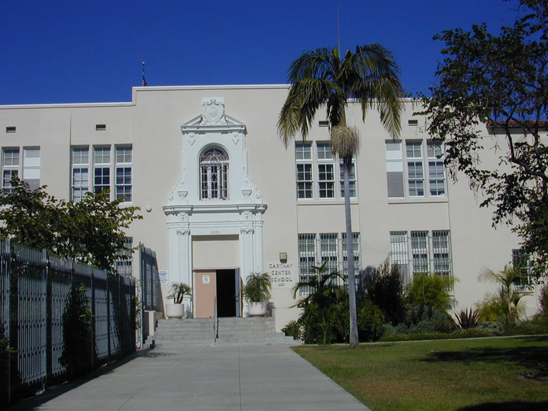
There is one school within Carthay's boundaries—Carthay Center Elementary, a K–6 school at 6351 West Olympic Boulevard. Starting in Fall 2014, Carthay Center Elementary became Carthay School of Environmental Studies Magnet, a residential full-school magnet. Spaces are reserved for students in the traditional attendance boundaries, but the school is also open to magnet school applicants from throughout LAUSD. The Environmental Studies program will be building on programs such as the celebrated Garden Science program at the school.
References
References
- [http://projects.latimes.com/mapping-la/neighborhoods/neighborhood/carthay] "Carthay," Mapping L.A., ''Los Angeles Times''
- [http://projects.latimes.com/mapping-la/neighborhoods/region/central-la/] "Central L.A.," Mapping L.A., ''Los Angeles Times''
- [http://projects.latimes.com/mapping-la/neighborhoods/region/westside/] "Westside," Mapping L.A., ''Los Angeles Times''
- [https://planning.lacity.gov/odocument/ab2f5674-8968-4e77-ad10-1557b6107f67/SurveyLAWilshire_SurveyReport_.pdf Historic Resources Survey Report: Wilshire Community Plan Area]
- "Carthay Circle - Office of Historic Resources, City of Los Angeles".
- "South Carthay - Office of Historic Resources, City of Los Angeles".
- "Carthay Square - Office of Historic Resources, City of Los Angeles".
- [http://projects.latimes.com/mapping-la/neighborhoods/carthay/schools]{{dead link. (June 2021)
- [http://projects.latimes.com/schools/school/los-angeles/carthay-center-elementary] "Carthay Center Elementary," Mapping L.A., ''Los Angeles Times''
- "Carthay Center Elementary School: Home Page".
- Ferenstein, Gregory. (12 May 2010). "If Michelle Obama Taught Biology, it Would Look Like This".
This article was imported from Wikipedia and is available under the Creative Commons Attribution-ShareAlike 4.0 License. Content has been adapted to SurfDoc format. Original contributors can be found on the article history page.
Ask Mako anything about Carthay, Los Angeles — get instant answers, deeper analysis, and related topics.
Research with MakoFree with your Surf account
Create a free account to save articles, ask Mako questions, and organize your research.
Sign up freeThis content may have been generated or modified by AI. CloudSurf Software LLC is not responsible for the accuracy, completeness, or reliability of AI-generated content. Always verify important information from primary sources.
Report