From Surf Wiki (app.surf) — the open knowledge base
Carroll County, Arkansas
County in Arkansas, United States

County in Arkansas, United States
| Field | Value |
|---|---|
| county | Carroll County |
| state | Arkansas |
| founded year | 1833 |
| founded date | November 1 |
| seat | Berryville and Eureka Springs |
| largest city | Berryville |
| area_total_sq_mi | 639 |
| area_land_sq_mi | 630 |
| area_water_sq_mi | 8.7 |
| area percentage | 1.4% |
| population_as_of | 2020 |
| population_total | 28260 |
| pop_est_as_of | 2024 |
| population_est | 28,968 |
| density_sq_mi | auto |
| web | http://carrollcounty.us/ |
| ex image | Carroll County Arkansas Courthouse.jpg |
| ex image cap | Carroll County Courthouse in Berryville |
| district | 3rd |
| time zone | Central |
| area codes | 479 (Eureka Springs) |
| 870 (Berryville) | |
| named for | Charles Carroll |
870 (Berryville)
Carroll County is a county located in the U.S. state of Arkansas. As of the 2020 census, the population was 28,260. The county has two county seats, Berryville and Eureka Springs. Carroll County is Arkansas's 26th county, formed on November 1, 1833, and named after Charles Carroll, the last surviving signer of the United States Declaration of Independence.
Geography
According to the U.S. Census Bureau, the county has a total area of 639 sqmi, of which 630 sqmi is land and 8.7 sqmi (1.4%) is water.
Major highways
- [[Image:US 62 (1961).svg|20px]] U.S. Highway 62
- [[File:US 62S.svg|25px]] U.S. Route 62 Spur
- [[Image:US 412.svg|25px]] U.S. Highway 412
- [[File:Arkansas 21.svg|20px]] Arkansas Highway 21
- [[File:Arkansas 23.svg|20px]] Arkansas Highway 23
- [[File:Arkansas 103.svg|25px]] Arkansas Highway 103
- [[File:Arkansas 143.svg|25px]] Arkansas Highway 143
- [[File:Arkansas 187.svg|25px]] Arkansas Highway 187
- [[File:Arkansas 221.svg|25px]] Arkansas Highway 221
- [[File:Arkansas 311.svg|25px]] Arkansas Highway 311
- [[File:Arkansas 980(Airport).svg|25px]] Arkansas Highway 980
Transit
- Jefferson Lines
Adjacent counties
- Stone County, Missouri (north)
- Taney County, Missouri (northeast)
- Boone County (east)
- Newton County (southeast)
- Madison County (south)
- Benton County (west)
- Barry County, Missouri (northwest)
Demographics
| align-fn = center 1790–1960 1900–1990 1990–2000 2010–2016
2020 census
As of the 2020 census, the county had a population of 28,260. The median age was 44.8 years. 21.9% of residents were under the age of 18 and 23.6% of residents were 65 years of age or older. For every 100 females there were 97.7 males, and for every 100 females age 18 and over there were 96.4 males age 18 and over.
17.9% of residents lived in urban areas, while 82.1% lived in rural areas.
There were 11,727 households in the county, of which 26.1% had children under the age of 18 living in them. Of all households, 47.8% were married-couple households, 19.5% were households with a male householder and no spouse or partner present, and 25.9% were households with a female householder and no spouse or partner present. About 30.9% of all households were made up of individuals and 15.4% had someone living alone who was 65 years of age or older.
There were 13,853 housing units, of which 15.3% were vacant. Among occupied housing units, 70.1% were owner-occupied and 29.9% were renter-occupied. The homeowner vacancy rate was 1.8% and the rental vacancy rate was 7.6%.
| Race | Percentage | White | Black or African American | American Indian and Alaska Native | Asian | Native Hawaiian and Pacific Islander | Some other race | Two or more races | Hispanic or Latino (of any race) |
|---|---|---|---|---|---|---|---|---|---|
| 77.7% | |||||||||
| 0.3% | |||||||||
| 1.3% | |||||||||
| 2.0% | |||||||||
| 1.6% | |||||||||
| 8.8% | |||||||||
| 8.3% | |||||||||
| 15.2% |
2000 census
As of the 2000 census, there were 25,357 people, 10,189 households, and 7,111 families residing in the county. The population density was 40 /mi2. There were 11,828 housing units at an average density of 19 /mi2. The racial composition of the county was 93.63% White, 0.11% Black or African American, 0.88% Native American, 0.41% Asian, 0.08% Pacific Islander, 3.34% from other races, and 1.55% from two or more races. 9.74% of the population were Hispanic or Latino of any race. 10.03% reported speaking Spanish at home.
There were 10,189 households, out of which 29.20% had children under the age of 18 living with them, 57.10% were married couples living together, 8.60% had a female householder with no husband present, and 30.20% were non-families. 25.20% of all households were made up of individuals, and 10.30% had someone living alone, who was 65 years of age or older. The average household size was 2.47 and the average family size was 2.93.
In the county, the population was spread out, with 24.00% under the age of 18, 8.10% from 18 to 24, 26.20% from 25 to 44, 26.00% from 45 to 64, and 15.80% who were 65 years of age or older. The median age was 39 years. For every 100 females there were 97.40 males. For every 100 females age 18 and over, there were 95.30 males.
The median income for a household in the county was $27,924, and the median income for a family was $33,218. Males had a median income of $21,896 versus $18,159 for females. The per capita income for the county was $16,003. About 11.00% of families and 15.50% of the population were below the poverty line, including 20.70% of those under age 18 and 13.60% of those age 65 or over.
Government and politics
The county government is a constitutional body granted specific powers by the Constitution of Arkansas and the Arkansas Code. The quorum court is the legislative branch of the county government and controls all spending and revenue collection. Representatives are called justices of the peace and are elected from county districts every even-numbered year. The number of districts in a county vary from nine to fifteen, and district boundaries are drawn by the county election commission. The Carroll County Quorum Court has eleven members. Presiding over quorum court meetings is the county judge, who serves as the chief operating officer of the county. The county judge is elected at-large and does not vote in quorum court business, although capable of vetoing quorum court decisions.
| Position | Officeholder | Party |
|---|---|---|
| County Judge | David Writer | Republican |
| County Clerk | Connie T. Doss | Republican |
| Circuit Clerk | Sara Huffman | Republican |
| Sheriff | Daniel Klatt | Republican |
| Treasurer | Makita Williams | Republican |
| Collector | Krista Burnett | Republican |
| Assessor | Jeannie Davidson | Democratic |
| Coroner | David Slaton | Republican |
The composition of the Quorum Court following the 2024 elections is 9 Republicans, 1 Democrat, and 1 Independent. Justices of the Peace (members) of the Quorum Court following the elections are:
- District 1: Jack Deaton (I) (position now VACANT)
- District 2: Stuart Bruce Wright (R) of Eureka Springs
- District 3: Harrie Farrow (D) of Eureka Springs
- District 4: Hunter Rivett (R) of Berryville
- District 5: Matt Phillips (R) of Berryville
- District 6: Craig Hicks (R) of Berryville
- District 7: Kellie Matt (R) of Eureka Springs
- District 8: Bobby James (R) of Green Forest
- District 9: Aaron Hall (R) of Green Forest
- District 10: Jerry King (R) of Green Forest
- District 11: Caroline Jane Roberts (R) of Alpena
Additionally, the townships of Carroll County are entitled to elect their own respective constables, as set forth by the Constitution of Arkansas. Constables are largely of historical significance as they were used to keep the peace in rural areas when travel was more difficult. The township constables as of the 2024 elections are:
- Central: Todd W. Summers (R)
- Northeast: Randy Langhover (R)
- Western: James Wallace (D)
The Eastern District (Berryville and Green Forest) is heavily Republican. The Western District (Eureka Springs and Beaver) tilts Democratic despite the fact that Holiday Island, a community with a large percentage of relocated snowbirds in the Western District, is overwhelmingly Republican.
In presidential elections, Carroll County has voted for the Democratic candidate only twice since 1952. It voted for Southerners Jimmy Carter in 1976, and Bill Clinton in 1992.
Communities

Cities
- Berryville (county seat)
- Eureka Springs (county seat)
- Green Forest
- Holiday Island
Towns
- Alpena (partly in Boone County)
- Beaver
- Blue Eye
- Oak Grove
Other unincorporated communities
- Carrollton Rudd Osage
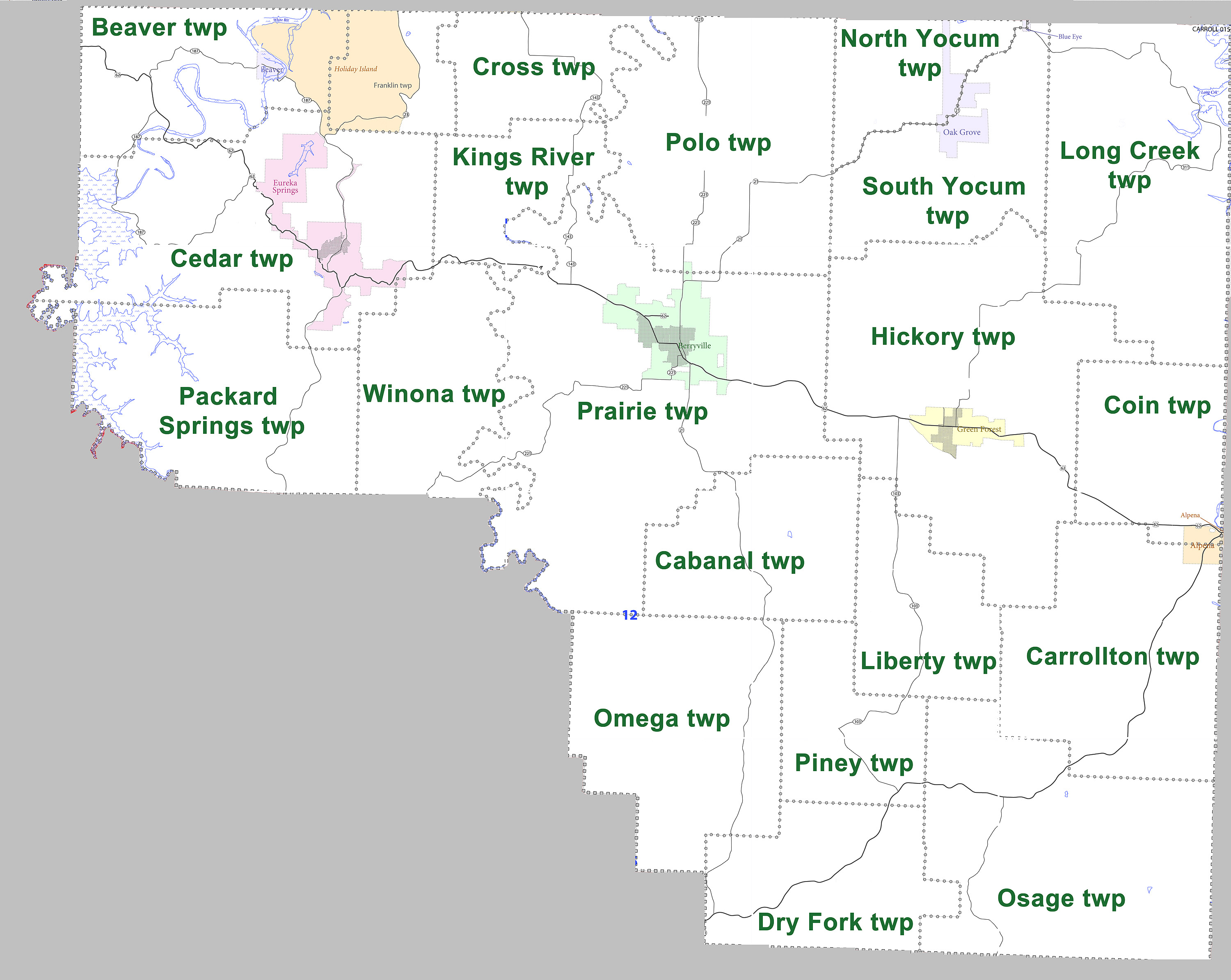
Townships
|archive-url=https://web.archive.org/web/20121019105150/http://www2.census.gov/geo/pvs/bas/bas11/st05_ar/cou/c05015_carroll/BAS11C20501500000_000.pdf |url-status=dead |archive-date=October 19, 2012 |access-date=July 26, 2011
| Township | FIPS code | ANSI code | |||||||||
|---|---|---|---|---|---|---|---|---|---|---|---|
| (GNIS ID) | Population | ||||||||||
| center(s) | Pop. | ||||||||||
| (2010) | Pop. | ||||||||||
| density | |||||||||||
| (/mi2) | Pop. | ||||||||||
| density | |||||||||||
| (/km2) | Land area | ||||||||||
| (mi2) | Land area | ||||||||||
| (km2) | Water area | ||||||||||
| (mi2) | Water area | ||||||||||
| (km2) | Geographic coordinates | ||||||||||
| Beaver | Beaver, Holiday Island | 1787 | 75.33 | 29.09 | 23.722 sqmi | 1.260 sqmi | |||||
| Cabanal | 381 | 16.59 | 6.41 | 22.966 sqmi | 0.013 sqmi | ||||||
| Carrollton | Alpena | 716 | 20.04 | 7.74 | 35.734 sqmi | 0.008 sqmi | |||||
| Cedar | Eureka Springs | 3575 | 78.90 | 30.46 | 45.312 sqmi | 3.260 sqmi | |||||
| Coin | Alpena | 655 | 34.13 | 13.18 | 19.191 sqmi | 0.037 sqmi | |||||
| Cross | 284 | 18.52 | 7.15 | 15.335 sqmi | 0.023 sqmi | ||||||
| Dry Fork | 292 | 12.55 | 4.85 | 23.263 sqmi | 0 sqmi | ||||||
| Franklin | Holiday Island | 1269 | 119.28 | 46.04 | 10.639 sqmi | 0 sqmi | |||||
| Hickory | Green Forest | 4977 | 87.20 | 33.67 | 57.078 sqmi | 0 sqmi | |||||
| King's River | 625 | 41.72 | 16.11 | 14.980 sqmi | 0 sqmi | ||||||
| Liberty | 158 | 8.60 | 3.32 | 18.368 sqmi | 0 sqmi | ||||||
| Long Creek | 614 | 14.33 | 5.53 | 42.834 sqmi | 0.971 sqmi | ||||||
| North Yocum | Blue Eye, Oak Grove | 314 | 24.15 | 9.32 | 13.004 sqmi | 0.017 sqmi | |||||
| Omega | 489 | 14.06 | 5.43 | 34.778 sqmi | 0 sqmi | ||||||
| Osage | 418 | 9.25 | 3.57 | 45.196 sqmi | 0.019 sqmi | ||||||
| Packard Springs | 735 | 22.44 | 8.66 | 32.761 sqmi | 2.944 sqmi | ||||||
| Piney | 226 | 13.99 | 5.40 | 16.150 sqmi | 0 sqmi | ||||||
| Polo | Berryville | 1224 | 29.90 | 11.55 | 40.932 sqmi | 0.006 sqmi | |||||
| Prairie | Berryville | 7555 | 106.85 | 41.25 | 70.706 sqmi | 0.144 sqmi | |||||
| South Yocum | Blue Eye, Oak Grove | 649 | 29.92 | 10.78 | 23.247 sqmi | 0 sqmi | |||||
| Winona | Eureka Springs | 453 | 18.96 | 7.32 | 23.889 sqmi | 0 sqmi | |||||
| Source: U.S. Census Bureau |
References
References
- "Explore Census Data".
- "Find a County". National Association of Counties.
- Gannett, Henry. (1905). "The Origin of Certain Place Names in the United States". Govt. Print. Off..
- (August 22, 2012). "2010 Census Gazetteer Files". United States Census Bureau.
- "Annual Estimates of the Resident Population for Counties: April 1, 2020 to July 1, 2023". United States Census Bureau.
- "U.S. Decennial Census". United States Census Bureau.
- "Historical Census Browser". University of Virginia Library.
- (March 27, 1995). "Population of Counties by Decennial Census: 1900 to 1990". United States Census Bureau.
- (April 2, 2001). "Census 2000 PHC-T-4. Ranking Tables for Counties: 1990 and 2000". United States Census Bureau.
- "State & County QuickFacts". United States Census Bureau.
- (2021). "2020 Decennial Census Demographic Profile (DP1)".
- (2023). "2020 Decennial Census Demographic and Housing Characteristics (DHC)".
- (2021). "2020 Decennial Census Redistricting Data (Public Law 94-171)".
- "U.S. Census website". [[United States Census Bureau]].
- "MLA Data Center Results".
- "Quorum Courts".
- "Office of County Judge".
- "Carroll {{!}} Association of Arkansas Counties".
- "Home Page - Carroll County Arkansas".
- (27 June 2022). "2022 General Election, General Election County, District Officials, County, District Officials".
- "Justices of the Peace - Carroll County Arkansas".
- "Carroll County, Arkansas, elections, 2024".
- "Election Night Reporting".
- "Arkansas: 2010 Census Block Maps - County Subdivision". [[United States Census Bureau]].
- "County Subdivisions: Arkansas". United States Census Bureau.
This article was imported from Wikipedia and is available under the Creative Commons Attribution-ShareAlike 4.0 License. Content has been adapted to SurfDoc format. Original contributors can be found on the article history page.
Ask Mako anything about Carroll County, Arkansas — get instant answers, deeper analysis, and related topics.
Research with MakoFree with your Surf account
Create a free account to save articles, ask Mako questions, and organize your research.
Sign up freeThis content may have been generated or modified by AI. CloudSurf Software LLC is not responsible for the accuracy, completeness, or reliability of AI-generated content. Always verify important information from primary sources.
Report