From Surf Wiki (app.surf) — the open knowledge base
Caribbean Netherlands
Caribbean municipalities of the Netherlands

Caribbean municipalities of the Netherlands
| Field | Value | |||||||||
|---|---|---|---|---|---|---|---|---|---|---|
| name | Caribbean Netherlands | |||||||||
| native_name | nl | |||||||||
| settlement_type | Overseas region of the Netherlands | |||||||||
| image_flag | Flag of the Netherlands.svg | |||||||||
| flag_size | 120 | |||||||||
| flag_link | Flag of the Netherlands | |||||||||
| image_seal | State coat of arms of the Netherlands.svg | |||||||||
| seal_size | 95 | |||||||||
| seal_type | Coat of arms | |||||||||
| seal_link | Coat of arms of the Netherlands | |||||||||
| anthem | nl | |||||||||
| () | ||||||||||
| [[File:United States Navy Band - Het Wilhelmus (tempo corrected).ogg | Het Wilhelmus]] | |||||||||
| image_map | BES islands location map.svg | |||||||||
| map_caption | Location of the Caribbean Netherlands (green and circled). From left to right: Bonaire, Saba, and Sint Eustatius | |||||||||
| elevation_max_m | 870 | |||||||||
| elevation_max_footnotes | ||||||||||
| (Mount Scenery) | ||||||||||
| subdivision_type | Country | |||||||||
| subdivision_name | Netherlands | |||||||||
| subdivision_type1 | Special municipalities | |||||||||
| subdivision_name1 | {{plainlist | |||||||||
| established_title | Incorporated into the Netherlands | |||||||||
| established_date | 10 October 2010 (dissolution of the Netherlands Antilles) | |||||||||
| leader_title1 | Monarch | |||||||||
| leader_name1 | Willem-Alexander | |||||||||
| leader_title2 | Lt. Governors (see Politics of the Netherlands) | |||||||||
| leader_name2 | {{plainlist | |||||||||
| * Alida Francis <ref>{{Cite web | url | https://www.rijksoverheid.nl/actueel/nieuws/2021/06/18/benoeming-regeringscommissaris-en-plaatsvervanger-sint-eustatius | title=Benoeming regeringscommissaris en plaatsvervanger Sint Eustatius | access-date=19 December 2021 | website=Government of the Netherlands | date=18 June 2021 | language=nl | archive-date=28 May 2023 | archive-url=https://web.archive.org/web/20230528224336/https://www.rijksoverheid.nl/actueel/nieuws/2021/06/18/benoeming-regeringscommissaris-en-plaatsvervanger-sint-eustatius | url-status=dead}} |
| leader_title3 | National Rep. | |||||||||
| leader_name3 | Jan Helmond | |||||||||
| population_density_km2 | 77 | |||||||||
| timezone | AST | |||||||||
| utc_offset | −4 | |||||||||
| coordinates | ||||||||||
| blank_name_sec1 | Currency | |||||||||
| blank_info_sec1 | United States dollar ($) (USD) | |||||||||
| blank_name_sec2 | Internet TLD | |||||||||
| blank_info_sec2 | {{ubl | .nl | .bq | |||||||
| iso_code | BQ, NL-BQ1, NL-BQ2, NL-BQ3 | |||||||||
| population_estimate_year | 2025 | |||||||||
| population_estimate | 31,980 | |||||||||
| GDP_nominal | US$725,000,000 | |||||||||
| GDP_nominal_year | 2022 | |||||||||
| area_km2 | 322 | |||||||||
| official_languages | Dutch | |||||||||
| recognised_regional_languages | {{plainlist | |||||||||
| * Papiamentu (Bonaire)<ref name | languages | |||||||||
| calling_code | +599 (Telephone numbers in the Caribbean Netherlands) | |||||||||
| largest_settlement | Kralendijk |
() (Mount Scenery)
-
Bonaire
-
Sint Eustatius
-
Saba
-
John Soliano (Bonaire)
-
Alida Francis (Sint Eustatius)
-
Jonathan Johnson (Saba)
-
English (Saba, St. Eustatius)
-
Papiamentu (Bonaire)
The Caribbean Netherlands (, ) is a geographic region of the Netherlands located outside of Europe, in the Caribbean, consisting of three special municipalities. These are the islands of Bonaire, Sint Eustatius, and Saba,"Bonaire, Sint Eustatius and Saba" is the listed English name for the territorial grouping in the International Organization for Standardization's ISO 3166-1, where the English spelling was corrected from Saint Eustatius with the release of ISO 3166-1 Newsletter VI-9 . as they are also known in legislation, or the BES islands for short. The islands are officially classified as public bodies in the Netherlands and as overseas territories of the European Union; as such, European Union law does not automatically apply to them.
Bonaire (including the islet of Klein Bonaire) is one of the Leeward Antilles and is located close to the coast of Venezuela. Sint Eustatius and Saba are in the main Lesser Antilles group and are located south of Sint Maarten and northwest of Saint Kitts and Nevis. The Caribbean Netherlands, a term distinct from the comprehensive Dutch Caribbean, has a population of 31,980.
Legal status
The three islands gained their current status following the dissolution of the Netherlands Antilles on 10 October 2010. At the same time, the islands of Curaçao and Sint Maarten became constituent countries () within the Kingdom of the Netherlands. The island of Aruba is also a constituent country of the Kingdom; Aruba gaining its status in 1986 after seceding from The Netherlands Antilles.
The constituent countries of the Dutch kingdom are autonomous (self-governing) while the special municipalities (Caribbean Netherlands) are legally part of the constituent country of The Netherlands. The Kingdom of the Netherlands consists of the constituent countries of Aruba, Curaçao, Sint Maarten and The Netherlands (which includes Bonaire, Saba, St. Eustatius).
The term "Dutch Caribbean" may refer to the three special municipalities (e.g. for stamps), but may also refer to all of the Caribbean islands within the Kingdom of the Netherlands. The Caribbean Netherlands, not to be confused with the comprehensive Dutch Caribbean, has a population of 31,980 as of 2025. Their total area is 328 km2.
In 2012, the islands of the Caribbean Netherlands voted for the first time, due to being special municipalities of the Netherlands, in the 2012 Dutch general election.
Administration
Administration
The special municipalities () carry many of the functions normally performed by Dutch municipalities. The executive power rests with the Governing Council headed by an Island governor. The main democratic body is the island council. Dutch citizens of these three islands are entitled to vote in Dutch national elections and (as all Dutch nationals) in European elections.
Officially the islands are classed in Dutch law as being openbare lichamen (literally translated as "public bodies") and not gemeenten (municipalities). Unlike normal municipalities, they do not form part of a Dutch province and the powers normally exercised by provincial councils within municipalities are divided between the island governments themselves and the central government by means of the National Office for the Caribbean Netherlands. For this reason, they are called "special" municipalities.
Many Dutch laws have a special Caribbean Netherlands version. For example, social security is not on the same level as it is in the European Netherlands.
| Flag | Name | Capital | Area | Population | |||||
|---|---|---|---|---|---|---|---|---|---|
| (January 2024) | Density | Total | 322 km2 | 30,397 | 77 /km2 | ||||
| Bonaire | Bonaire | 288 km2 | 25,133 | 69 /km2 | |||||
| Sint Eustatius | Sint Eustatius | 21 km2 | 3,204 | 150 /km2 | |||||
| Saba | Saba | 13 km2 | 2,060 | 148 /km2 |
National Office
The National Office for the Caribbean Netherlands () is responsible for taxation, policing, immigration, transport infrastructure, health, education, and social security in the islands and provides these services on behalf of the Government of the Netherlands. This agency was established as the Regional Service Center in 2008 and became the National Office for the Caribbean Netherlands on 1 September 2010. The current director is Jan Helmond. The Representative for the public bodies of Bonaire, Sint Eustatius and Saba represents the Government of the Netherlands on the islands and also performs tasks similar to a King's Commissioner. The current representative is Gilbert Isabella.
Relationship with the European Union
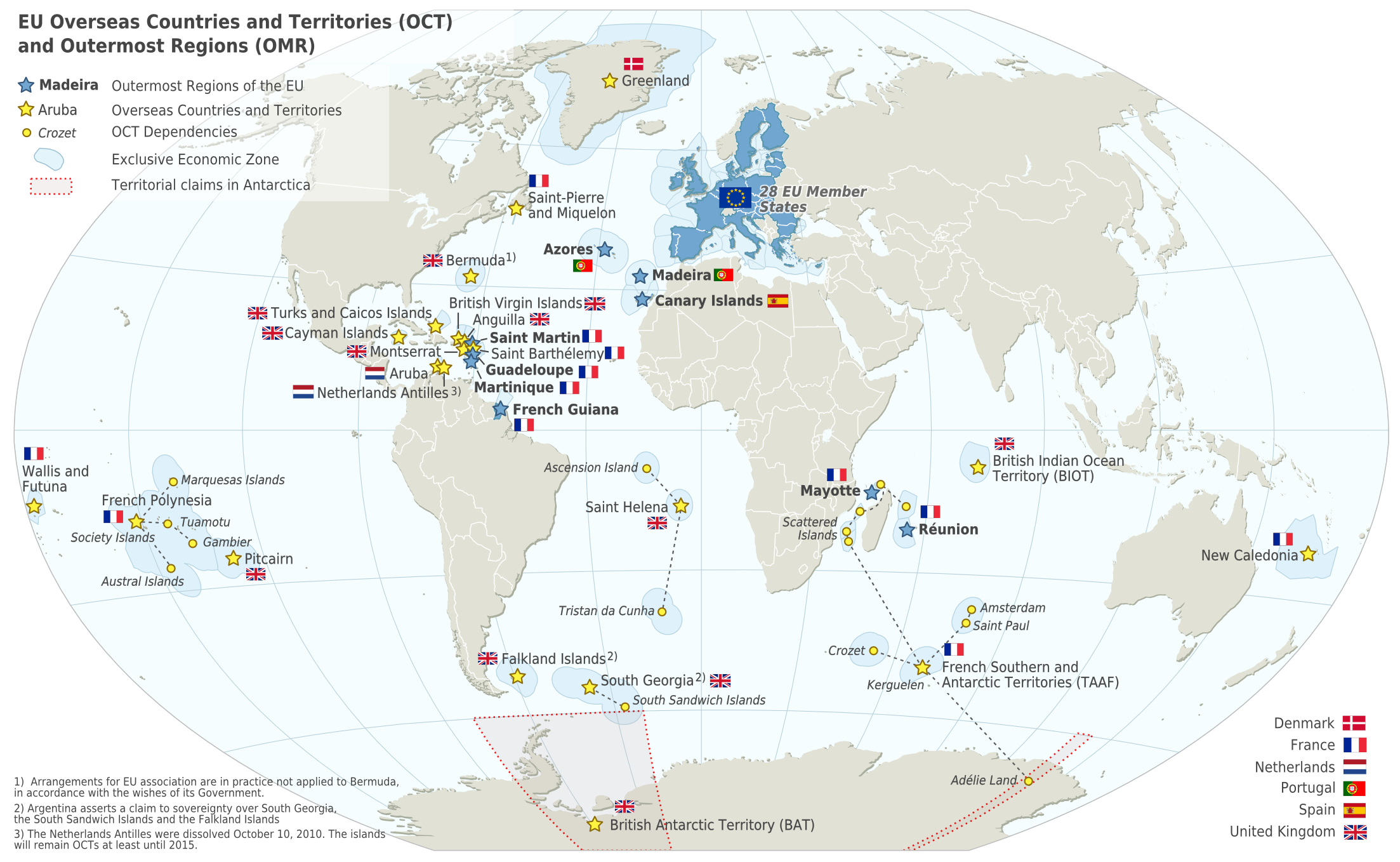
The islands do not form part of the European Union and instead constitute "overseas countries and territories" (OCT status) of the Union, to which special provisions apply.Per the Annex II of the Treaty on the Functioning of the European Union. The Lisbon Treaty introduced a procedure where the European Council may change the status of an overseas territory of Denmark, France, or the Netherlands regarding the application of the EU treaties to that territory.Now contained in Article 355(6) of the Treaty on the Functioning of the European Union. In June 2008, the Dutch government published a survey of the legal and economic impacts by a switched status from OCT to outermost region (OMR). The position of the islands was reviewed after a five-year transitional period, which began with the dissolution of the Netherlands Antilles in October 2010. The review was conducted as part of the planned review of the Dutch "Act for the public bodies Bonaire, Sint Eustatius and Saba" (), where the islands have been granted the option to become an OMR – and thus a direct part of the European Union. In October 2015, the review concluded the present legal structures for governance and integration with European Netherlands was not working well within the framework of WolBES, but no recommendations were made in regards of whether a switch from OCT to OMR status would help improve this situation.
Foreign policy and defence
The Kingdom of the Netherlands has overarching responsibility for foreign relations, defence and Dutch nationality law in the Caribbean parts of the Kingdom. Units of the Netherlands Armed Forces deployed in the Caribbean include:
- 32 Infantry Company of the Royal Netherlands Marine Corps on Aruba;
- a Marine Corps detachment on Sint Maarten;
- a Fast Raiding Interception and Special Forces Craft (FRISC) troop (fast boats) on Curaçao and Aruba;
- a company of the Royal Netherlands Army on Curaçao on a rotational basis;
- a guardship, normally a , from the Royal Netherlands Navy on station on a rotational basis;
- the Royal Netherlands Navy support vessel ;
- Arumil (Aruban) and Curmil (Curaçaoan) militia elements;
- a Netherlands Armed Forces Royal Marechaussee brigade.
Additionally, the Dutch Caribbean Coast Guard is funded by the four countries of the Kingdom of the Netherlands. The Coast Guard is managed by the Ministry of Defence and is directed by the commander of the Royal Netherlands Navy in the Caribbean.
Geography
The Caribbean Netherlands form part of the Lesser Antilles. Within this island group:
- Bonaire is part of the ABC islands within the Leeward Antilles island chain off the Venezuelan coast. The Leeward Antilles have a mixed volcanic and coral origin.
- Saba and Sint Eustatius are part of the SSS islands within the Leeward Islands. They are located east of Puerto Rico and the Virgin Islands. The locals (French, Spanish, Dutch and the locally spoken English) consider them part of the Windward Islands, although, in the international English language, the Windward Islands refer to other islands farther south. These two islands are of volcanic origin and hilly, leaving little ground suitable for agriculture. The highest point is Mount Scenery, 870 m, on Saba. This is the highest point in the country and in the entire Kingdom of the Netherlands.
File:Caribbean Netherlands map.png|Map showing Bonaire, Sint Eustatius, and Saba File:The Netherlands (incl. BES) in the Kingdom of the Netherlands.svg|Relative distance between mainland Netherlands in Europe and the Caribbean Netherlands File:Kingdom of the Netherlands location tree.svg|The Caribbean BES islands are subdivisions of the country of the Netherlands and are therefore referred to as the "Caribbean Netherlands." File:Bonaire - Caribe (358903421).jpg|Klein Bonaire (Bonaire in the background) File:Corner Point (6550002273).jpg|The hilly terrain of Saba
Climate
The islands of the Caribbean Netherlands enjoy a tropical climate with warm weather all year round. The Leeward Antilles are warmer and drier than the Windward islands. In summer, the Windward Islands can be subject to hurricanes.
Forest cover is around 6% of the total land area of the Caribbean Netherlands, equivalent to 1,910 hectares (ha) of forest in 2020, which was unchanged from 1990. In 2020, naturally regenerating forest covered 1,910 hectares (ha) and planted forest covered 0 hectares (ha). Of the naturally regenerating forest 0% was reported to be primary forest (consisting of native tree species with no clearly visible indications of human activity) and around 17% of the forest area was found within protected areas.
Currency
Until 1 January 2011, the three islands used the Netherlands Antillean guilder; after that all three switched to the U.S. dollar, rather than the euro (which is used in the European Netherlands) or the Caribbean guilder (which is being adopted by the other two former Antillean islands of Curaçao and Sint Maarten).
Communications
The telephone country code remains 599, that of the former Netherlands Antilles, and is shared with Curaçao. The International Organization for Standardization has assigned the ISO 3166-1 alpha-2 country code ISO 3166-2:BQ for these islands. The IANA has not established a root zone for the .bq Internet ccTLD and whether it will be used is unknown.
Notes
References
References
- (18 June 2021). "Benoeming regeringscommissaris en plaatsvervanger Sint Eustatius".
- (30 September 2010). "Wet geldstelsel BES". Dutch government.
- "BQ – Bonaire, Sint Eustatius and Saba". [[International Organization for Standardization.
- (20 December 2010). "Delegation Record for .BQ". [[Internet Assigned Numbers Authority.
- "Population of The Caribbean Netherlands up by nearly 1.6 thousand in 2024"%20than%20one%20year%20previously.).
- {{cite Q. Q131100722
- Zaken, Ministerie van Algemene. (19 May 2015). "Waaruit bestaat het Koninkrijk der Nederlanden?".
- "Invoeringswet openbare lichamen Bonaire, Sint Eustatius en Saba". wetten.nl.
- (3 April 2023). "The Security Strategy for the Kingdom of the Netherlands". Government of the Netherlands.
- (3 February 2014). "Nature Policy Plan The Caribbean Netherlands". [[Ministry of Economic Affairs (Netherlands).
- (12 September 2017). "What are the different parts of the Kingdom of the Netherlands?". Government of the Netherlands.
- Netherlands, Statistics. (2025-05-19). "Population of the Caribbean Netherlands up by nearly 1.6 thousand in 2024"%20than%20one%20year%20previously).
- (1 October 2010). "Besluit van 23 september 2010 tot vaststelling van het tijdstip van inwerkingtreding van de artikelen I en II van de Rijkswet wijziging Statuut in verband met de opheffing van de Nederlandse Antillen". Overheid.nl.
- (14 December 2011). "Caribbean Parts of the Kingdom". Government.nl.
- Netherlands, Statistics. (2025-05-19). "Population of the Caribbean Netherlands up by nearly 1.6 thousand in 2024"%20than%20one%20year%20previously.).
- "Verkiezingen Caribische graadmeter – Binnenland – Telegraaf.nl".
- "31.954, Wet openbare lichamen Bonaire, Sint Eustatius en Saba". Eerste kamer der Staten-Generaal.
- "Wet- en regelgeving".
- "The Dutch Caribbean - Dutch Caribbean Legal Portal".
- Rob Bijl and Evert Pommer. "Summary and conclusions – The Caribbean Netherlands five years after the transition".
- "Population Of The Caribbean Netherlands Up By Nearly a Thousand (2024)". Centraal Bureau voor de Statistiek.
- "Vacatures". Rijksdienst Caribisch Nederland.
- "Rijksdienst Caribisch Nederland". Rijksdienst Caribisch Nederland.
- "FAQ". Rijksdienst Caribisch Nederland.
- "Agreement on labor conditions Civil servants Rijksdienst Caribisch Nederland". Rijksdienst Caribisch Nederland.
- "Mr. Isabella will be Kingdom Representative for the public entities Bonaire, St. Eustatius and Saba". Rijksdienst Caribisch Nederland.
- (19 June 2008). "Schurende rechtsordes: Over juridische implicaties van de UPG-status voor de eilandgebieden van de Nederlandse Antillen en Aruba (Rijksuniversiteit Groningen)". Eerstekamer.nl.
- (19 June 2008). "Economische gevolgen van de status van ultraperifeer gebied voor de Nederlandse Antillen en Aruba / SEOR". Eerstekamer.nl.
- (21 October 2008). "Tweede Kamer, vergaderjaar 2008–2009, 31700 IV, nr.3: Brief van de staatssecretaris van Binnenlandse Zaken en Koninkrijksrelaties met het kabinetsstandpunt over de rapporten over de UPG status voor de eilandgebieden van de Nederlandse Antillen en Aruba". Eerstekamer.nl.
- (14 October 2009). "Kamerstuk 31954 nr.7: Regels met betrekking tot de openbare lichamen Bonaire, Sint Eustatius en Saba (Wet openbare lichamen Bonaire, Sint Eustatius en Saba)". Overheid.nl.
- Pro Facto – Rijksuniversiteit Groningen. (August 2015). "Vijf jaar Caribisch Nederland: De werking van wetgeving".
- DSP-Groep. (23 September 2015). "Vijf jaar Caribisch Nederland: Werking van de nieuwe bestuurlijke structuur".
- Sociaal en Cultureel Planbureau. (October 2015). "Vijf jaar Caribisch Nederland: Gevolgen voor de bevolking".
- Evaluatiecommissie Caribisch Nederland. (12 October 2015). ["VIJFJAAR VERBONDE BONAIRE, SINT EUSTATIUS, SABA EN EUROPEES NEDERLAND (Rapport van de commissie evaluatie uitwerking van de nieuwe staatkundige structuur Caribisch Nederland)"](http://deugdelijkbestuuraruba.org/wp-content/uploads/2016/04/Evaluatiecommissie-Vijf-jaar-verbonden-Bonaire-Sint-Eustatius-Saba-en-Europees-Nederland.pdf ).
- (16 October 2019). "Responsibilities of the Netherlands, Aruba, Curaçao and St Maarten – Caribbean Parts of the Kingdom – Government.nl".
- (6 April 2018). "Commander Netherlands Forces in the Caribbean – Royal Netherlands Navy – Defensie.nl".
- (3 June 2022). "Units and locations – Caribbean territories – Defensie.nl".
- (7 November 2022). "Kustwacht – Taken in Nederland – Defensie.nl".
- (2023). "Terms and Definitions FRA 2025 Forest Resources Assessment, Working Paper 194". Food and Agriculture Organization of the United Nations.
- "Global Forest Resources Assessment 2020, Bonaire, Sint Eustatius and Saba".
- "The Dutch Caribbean". Dutch Caribbean Legal Portal.
- "ISO 3166-1 decoding table". International Organization for Standardization.
This article was imported from Wikipedia and is available under the Creative Commons Attribution-ShareAlike 4.0 License. Content has been adapted to SurfDoc format. Original contributors can be found on the article history page.
Ask Mako anything about Caribbean Netherlands — get instant answers, deeper analysis, and related topics.
Research with MakoFree with your Surf account
Create a free account to save articles, ask Mako questions, and organize your research.
Sign up freeThis content may have been generated or modified by AI. CloudSurf Software LLC is not responsible for the accuracy, completeness, or reliability of AI-generated content. Always verify important information from primary sources.
Report