From Surf Wiki (app.surf) — the open knowledge base
Capital Regional District
Regional district in British Columbia, Canada
Regional district in British Columbia, Canada
| Field | Value | |
|---|---|---|
| name | Capital | |
| official_name | Capital Regional District | |
| nickname | CRD | |
| motto | Making a difference...together | |
| settlement_type | Regional district | |
| flag_alt | Ca-bc-cp.jp | |
| image_seal | Capital Regional District logo 2017.png | |
| seal_type | Logo | |
| imagesize | 150 | |
| image_map | {{Location map+ | CAN BC Capital |
| float | center | |
| label | Victoria | |
| mark | Western Canada Map Assets City.svg | |
| marksize | 8 | |
| position | right | |
| lat_deg | 48.428611 | |
| lon_deg | -123.365556}} | |
| label | Langford | |
| mark | Western Canada Map Assets City.svg | |
| marksize | 8 | |
| position | left | |
| lat_deg | 48.450556 | |
| lon_deg | -123.505833}} | |
| label | Saanich | |
| mark | Western Canada Map Assets Town.svg | |
| marksize | 6 | |
| position | top | |
| lat_deg | 48.484 | |
| lon_deg | -123.381}} | |
| label | Esquimalt | |
| mark | Western Canada Map Assets Town.svg | |
| marksize | 6 | |
| position | bottom | |
| lat_deg | 48.430556 | |
| lon_deg | -123.414722}} | |
| label | Sidney | |
| mark | Western Canada Map Assets Town.svg | |
| marksize | 6 | |
| position | left | |
| lat_deg | 48.650556 | |
| lon_deg | -123.398611}} | |
| label | North Saanich | |
| mark | Western Canada Map Assets Town.svg | |
| marksize | 6 | |
| position | right | |
| lat_deg | 48.614167 | |
| lon_deg | -123.42}} | |
| label | Sooke | |
| mark | Western Canada Map Assets Town.svg | |
| marksize | 6 | |
| position | left | |
| lat_deg | 48.376111 | |
| lon_deg | -123.737778}} | |
| label | Salt Spring Island | |
| mark | Western Canada Map Assets Hamlet.svg | |
| marksize | 4 | |
| position | left | |
| lat_deg | 48.833333 | |
| lon_deg | -123.5}} | |
| map_caption | Major communities | |
| image_map1 | CAN BC Capital Regional District locator.svg | |
| map_caption1 | Location in British Columbia | |
| pushpin_map | ||
| pushpin_label_position | ||
| subdivision_type | Country | |
| subdivision_name | Canada | |
| subdivision_type1 | Province | |
| subdivision_name1 | British Columbia | |
| seat_type | Administrative office location | |
| seat | Victoria | |
| government_footnotes | ||
| governing_body | Board of directors | |
| leader_title | Chair | |
| leader_name | Colin Plant (Saanich) | |
| leader_title1 | Vice chair | |
| leader_name1 | Maja Tait (Sooke) | |
| leader_title2 | Electoral areas | |
| leader_name2 | {{Plainlist | |
| established_title | Incorporated | |
| established_date | 1966 | |
| area_footnotes | ||
| area_total_km2 | 2340.49 | |
| area_land_km2 | ||
| population_as_of | 2021 | |
| population_footnotes | ||
| population_total | 415451 | |
| population_density_km2 | 177.7 | |
| timezone | PST | |
| utc_offset | -8 | |
| timezone_DST | PDT | |
| utc_offset_DST | -7 | |
| elevation_footnotes | ||
| area_codes | 250 / 778 / 236 / 672 | |
| website |
- Juan de Fuca
- Salt Spring Island
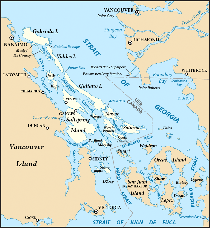
- Southern Gulf Islands The Capital Regional District (CRD) is a local government administrative district encompassing the southern tip of Vancouver Island and the southern Gulf Islands in the Canadian province of British Columbia. The CRD is one of several regional districts in British Columbia and had an official population of 415,451 as of the Canada 2021 Census.
The CRD encompasses the thirteen municipalities of Greater Victoria and three unincorporated areas: Juan de Fuca Electoral Area on Vancouver Island, Salt Spring Island Electoral Area, and Southern Gulf Islands Electoral Area. The CRD also acts as the local government for most purposes in the Electoral Areas. CRD headquarters is in the City of Victoria, although there are many office and operational facilities throughout the region. The total land area is 2341.11 km².
The CRD was formed in 1966 as a federation of seven municipalities and five electoral areas to provide coordination of regional issues and local government in rural areas in the Greater Victoria region.
Demographics
As a census division in the 2021 Census of Population conducted by Statistics Canada, the Capital Regional District had a population of living in of its total private dwellings, a change of from its 2016 population of . With a land area of 2338.22 km2, it had a population density of in 2021.
Ethnicity
The Capital Regional District (CRD) in British Columbia has a mostly European population , but it includes a diverse and growing mix of other ethnic groups. As of the 2021 Census, the approximate ethnic breakdown is as follows:
- European: 78.85%
- East Asian: 5.77%
- Indigenous (First Nations): 4.97%
- South Asian: 3.40%
- Southeast Asian: 3.08%
- African: 1.27%
- Latin American: 0.99%
- Middle Eastern: 0.87%
- Other: 0.79%
Results can sum to more than 100% because people may report multiple ethnic origins.
The visible minority population in the CRD, especially in Greater Victoria, is lower than the provincial average. In 2021, about 16.7% of Greater Victoria residents identified as visible minorities, compared to 34.4% in all of British Columbia. The largest visible minority groups in the region are Chinese (4.5%), South Asian (3.5%), and Filipino(2.2%).
| Panethnic | |||||||||||||||||||||||||||
|---|---|---|---|---|---|---|---|---|---|---|---|---|---|---|---|---|---|---|---|---|---|---|---|---|---|---|---|
| group | 2021 | 2016 | 2011 | 2006 | 2001 | Pop. | % | Pop. | % | Pop. | % | Pop. | % | Pop. | % | Total responses | 406,080 | 372,875 | 351,060 | 340,055 | 320,710 | Total population | 415,451 | 383,360 | 359,991 | 345,164 | 325,754 |
| European | 320,205 | 304,005 | 297,865 | 294,380 | 284,025 | ||||||||||||||||||||||
| East Asian | 23,415 | 21,205 | 16,270 | 16,015 | 13,900 | ||||||||||||||||||||||
| Indigenous | 20,195 | 17,880 | 14,780 | 11,365 | 9,100 | ||||||||||||||||||||||
| South Asian | 13,825 | 10,280 | 7,620 | 7,300 | 5,805 | ||||||||||||||||||||||
| Southeast Asian | 12,490 | 8,700 | 6,260 | 4,410 | 3,085 | ||||||||||||||||||||||
| African | 5,175 | 3,535 | 2,975 | 2,380 | 2,235 | ||||||||||||||||||||||
| Latin American | 4,015 | 2,675 | 1,885 | 1,890 | 1,190 | ||||||||||||||||||||||
| Middle Eastern | 3,535 | 2,575 | 1,725 | 1,095 | 690 | ||||||||||||||||||||||
| Other | 3,225 | 2,010 | 1,675 | 1,230 | 685 |
- Note: Totals greater than 100% due to multiple origin responses.
Political divisions
The CRD comprises the 13 municipalities of Greater Victoria, three electoral areas and 10 Indigenous reserves. The reserves have a relatively small portion of the population with 5,244 participating in the 2016 census. Some reserves did not participate; those that did are included in the population figures of the municipality or electoral area encompassing them, however the CRD regional government and local governments have no jurisdiction over reserves. Saanich and Victoria together have over 50 percent of the region's population.
| Division | Census Subdivision type | Population | ||||||
|---|---|---|---|---|---|---|---|---|
| (2021) | Population | |||||||
| (2016) | Change | |||||||
| (2016-2021) | Total Capital Regional District | 415,451 | 383,360 | 8.4% | ||||
| Saanich | District municipality | 117,735 | 114,148 | 3.1% | ||||
| Victoria | City | 91,867 | 85,792 | 7.1% | ||||
| Langford | City | 46,584 | 35,342 | 31.8% | ||||
| Oak Bay | District municipality | 17,990 | 18,094 | -0.6% | ||||
| Esquimalt | Town | 17,533 | 17,655 | -0.7% | ||||
| Colwood | City | 18,961 | 16,859 | 12.5% | ||||
| Central Saanich | District municipality | 17,385 | 16,814 | 3.4% | ||||
| Sooke | District municipality | 15,086 | 13,001 | 16.0% | ||||
| Sidney | Town | 12,318 | 11,672 | 5.5% | ||||
| North Saanich | District municipality | 12,235 | 11,249 | 8.8% | ||||
| View Royal | Town | 11,575 | 10,408 | 11.2% | ||||
| Metchosin | District municipality | 5,067 | 4,708 | 7.6% | ||||
| Highlands | District municipality | 2,482 | 2,225 | 11.6% | ||||
| Salt Spring Island | Regional district electoral area | 11,635 | 10,557 | 10.2% | ||||
| Juan de Fuca | Regional district electoral area | 5,531 | 4,860 | 13.8% | ||||
| Southern Gulf Islands | Regional district electoral area | 6,101 | 4,732 | 28.9% |
Electoral Areas
Salt Spring Island Electoral Area
The Salt Spring Island Electoral Area of the Capital Regional District (CRD) of British Columbia consists of unincorporated areas in the CRD located on Salt Spring Island. It is represented by one director on the CRD.
The major localities encompassed by the electoral area are:
- Ganges
- Fulford Harbour
- Vesuvius Bay
- Long Harbour
- Beaver Point
- Musgrave Landing
According to the Canada 2021 Census:
- Population: 11,635
- % Change (2016-2021): 28.9
- Area (km².): 182.23
- Density (persons per km².): 63.8
Southern Gulf Islands Electoral Area
The Southern Gulf Islands Electoral Area of the Capital Regional District (CRD) of British Columbia consists of unincorporated districts in the CRD located on Galiano, Saturna, Mayne, and North and South Pender Islands, as well as many smaller islands located in the Gulf of Georgia north and east of Victoria. It is previously known as the Outer Gulf Islands Electoral Area. Its population of 6,101 is represented by one director on the CRD.
The major localities encompassed by the electoral area are:
- Bedwell Harbour (South Pender Island)
- Montague Harbour (Galiano Island)
- Otter Bay (North Pender Island)
- Saturna (Saturna Island)
- Sturdies Bay (Galiano Island)
- Village Bay (Mayne Island)
Juan de Fuca Electoral Area
The Juan de Fuca Electoral Area is an Electoral Area of the CRD. It consists of the District's unincorporated land on Vancouver Island, including the neighbourhood of Willis Point on the Saanich Inlet, Malahat, on the western shore of Saanich Inlet, and the Western Communities localities of East Sooke, Jordan River, Otter Point, Shirley, Port Renfrew, inclusive of the First Nations reserves of Gordon River 2 and Pacheena 1, which are within its territory. Its population of 5,531 is represented by a single director of the CRD. The total land area is 1,502.24 km2 (580.0 sq mi). Population figures do not included residents of Indian Reserves, whether band members or non-indigenous persons.
Administrative role
The board of directors are either directly elected officials or are appointed from within the region's elected municipal councils.
The CRD's responsibilities include recycling, operating the regional landfill, building and operating sewage treatment plants, a sewer source control program, regional water supply, funding for non-profit arts groups, regional planning, funding health facilities, and overseeing thirty regional parks, trails, and regional park reserves encompassing over 100 km2. The CRD is the sole shareholder of the Capital Region Housing Corporation, which owns and operates over 1200 rental housing units. In certain areas, the CRD can pass bylaws that are binding on a portion of the geographical area or the entire geographical area. These include a "clean air bylaw" smoking ban in all public places and patios in restaurants/pubs.
The CRD assumes responsibilities ordinarily undertaken by municipalities in unincorporated areas of the CRD. These responsibilities include animal control, building inspection, fire protection, and bylaw enforcement. Some of the region's municipalities avail themselves of some of these services in a contractual arrangement with the CRD.
Capital Regional Hospital District
The CRHD's primary responsibility is to provide the region's share of capital funding for the region's health facilities and equipment. The region's health care delivery is the responsibility of the Vancouver Island Health Authority (VIHA). The CRHD shares the same Board of Directors with the CRD.
Gallery
Notes
References
;Specific
;General
References
- "CRD Board of Directors".
- . (September 4, 2013). ["What is CRD"](https://www.crd.bc.ca/about/what-is-crd).
- . (February 9, 2022). ["Census Profile, 2021 Census"](https://www12.statcan.gc.ca/census-recensement/2021/dp-pd/prof/details/page.cfm?Lang=E&Geo1=CD&Code1=5917&Geo2=PR). *Statistics Canada*.
- {{BCGNIS. 38667. Capital Regional District
- [https://www12.statcan.gc.ca/census-recensement/2021/dp-pd/prof/details/page.cfm?Lang=E&SearchText=capital&DGUIDlist=2021A000011124,2021A00035917&GENDERlist=1&STATISTIClist=1&HEADERlist=0Community Profile: Capital Regional District, British Columbia; Statistics Canada]. Retrieved 2022-02-10
- [http://www.crd.bc.ca/about/index.htm CRD webpage] {{Webarchive. link. (December 2, 2020 . Retrieved 2011-10-20)
- (February 9, 2022). "Population and dwelling counts: Canada and census divisions". [[Statistics Canada]].
- Government of Canada, Statistics Canada. (2017-02-08). "Census Profile, 2016 Census - Capital, Regional district [Census division], British Columbia and British Columbia [Province]".
- Government of Canada, Statistics Canada. (2022-10-26). "Census Profile, 2021 Census of Population".
- Government of Canada, Statistics Canada. (2021-10-27). "Census Profile, 2016 Census".
- Government of Canada, Statistics Canada. (2015-11-27). "NHS Profile".
- Government of Canada, Statistics Canada. (2019-08-20). "2006 Community Profiles".
- Government of Canada, Statistics Canada. (2019-07-02). "2001 Community Profiles".
- (September 4, 2013). "About the Region". Capital Regional District.
- (February 8, 2018). "Population and dwelling counts, for Canada, provinces and territories, and census subdivisions (municipalities), 2016 and 2011 censuses – 100% data (British Columbia)". [[Statistics Canada]].
- (February 9, 2022). "Population and dwelling counts, for Canada, provinces and territories, and census subdivisions (municipalities) (British Columbia)". [[Statistics Canada]].
- (February 9, 2022). "Capital, Regional district [Census division], British Columbia and Juan de Fuca (Part 1), Regional district electoral area [Census subdivision], British Columbia". [[Statistics Canada]].
- (2013-10-07). "Capital Regional Hospital District".
This article was imported from Wikipedia and is available under the Creative Commons Attribution-ShareAlike 4.0 License. Content has been adapted to SurfDoc format. Original contributors can be found on the article history page.
Ask Mako anything about Capital Regional District — get instant answers, deeper analysis, and related topics.
Research with MakoFree with your Surf account
Create a free account to save articles, ask Mako questions, and organize your research.
Sign up freeThis content may have been generated or modified by AI. CloudSurf Software LLC is not responsible for the accuracy, completeness, or reliability of AI-generated content. Always verify important information from primary sources.
Report