From Surf Wiki (app.surf) — the open knowledge base
Canton of St. Gallen
Canton of Switzerland

Canton of Switzerland
| Field | Value | ||||
|---|---|---|---|---|---|
| <!-- See Template:Infobox settlement for additional fields and descriptions --> | name | Canton of St. Gallen | |||
| native_name | de | ||||
| other_name | Canton of St Gall | ||||
| settlement_type | Canton | ||||
| image_flag | Flag of Canton of Sankt Gallen.svg | ||||
| image_shield | Coat of arms of canton of St. Gallen.svg | ||||
| subdivision_type | Country | ||||
| subdivision_name | Switzerland | ||||
| shield_size | 80x80px | ||||
| mapframe | yes | ||||
| mapframe-zoom | 6 | ||||
| mapframe-point | none | ||||
| map_alt | Map of Switzerland, location of St. Gallen highlighted | ||||
| map_caption | Location in Switzerland | ||||
| {{hidden | ta1 | left | border = 1px solid grey | header = Map of St. Gallen | content = |
| [[File:Karte Kanton St. Gallen 2010.png | 250px]] }} | ||||
| coordinates | |||||
| seat_type | Capital | ||||
| seat | St. Gallen | ||||
| parts_type | Subdivisions | ||||
| parts_style | para | ||||
| p1 | 77 municipalities | ||||
| p2 | 8 districts | ||||
| leader_title | President | ||||
| leader_name | Susanne Hartmann | ||||
| leader_title2 | Executive | ||||
| leader_name2 | Regierung (7) | ||||
| leader_title3 | Legislative | ||||
| leader_name3 | Kantonsrat (180) | ||||
| area_footnotes | |||||
| area_total_km2 | |||||
| population_footnotes | |||||
| population_total | |||||
| population_as_of | |||||
| population_density_km2 | auto | ||||
| demographics_type1 | GDP | ||||
| demographics1_footnotes | |||||
| demographics1_title1 | Total | ||||
| demographics1_info1 | CHF 38.041 billion (2020) | ||||
| demographics1_title2 | Per capita | ||||
| demographics1_info2 | CHF 74,210 (2020) | ||||
| iso_code | CH-SG | ||||
| blank_name_sec1 | Highest point | ||||
| blank_info_sec1 | 3248 m: Ringelspitz | ||||
| blank1_name_sec1 | Lowest point | ||||
| blank1_info_sec1 | 396 m: Lake Constance | ||||
| blank_name_sec2 | Joined | ||||
| blank_info_sec2 | 1803 | ||||
| blank1_name_sec2 | Languages | ||||
| blank1_info_sec2 | German | ||||
| website |
| mapframe-zoom = 6 | mapframe-point = none The canton of St. Gallen or St Gall ( ; ; ; ) is a canton of Switzerland. Its capital is St. Gallen.
Located in northeastern Switzerland, the canton has an area of 2026 km2 (5% of Switzerland) and a resident population close to half a million as of 2015 (6% of Switzerland). It was formed in 1803 as a conflation of the city of St. Gallen, the territories of the Abbey of St. Gall and various former subject territories of the Old Swiss Confederacy.
History
County of Toggenburg, Rapperswil, Uznach, Windegg (Gaster), County of Sargans, Pfäfers Abbey, Werdenberg, Lordship of Hohensax, Barony of Sax-Forstegg and Rheintal]] Prehistoric human activity in the area of the canton of St. Gallen is evidenced by the findings of stone tools and animal bones at Wildenmannlisloch cave in the Toggenburg region, which date back to the Paleolithic period (40,000–35,000 years ago). Slightly older are the finds at () cave in the Sarganserland region.
The Tabula Peutingeriana shows a Roman road and a settlement, Ad Rhenum (around present-day Rheineck/St. Margrethen), near the southern coast of Lake Constance. Centum Prata was a Roman vicus, now located in the municipality of Rapperswil-Jona. The , a Roman watchtower in the municipality of Amden, dates back to 15 BC.
The canton of St. Gallen is an artificial construct of various historical territories, defined by Napoleon Bonaparte in the Act of Mediation in 1803. About half of the canton's area corresponds to the acquisitions of the abbey of St. Gallen over centuries.
The city of St. Gallen became independent of the abbey in 1405. At the same time, the abbey lost control of Appenzell. Conversely, the Toggenburg was acquired by the Abbey in 1468. Both the city and the abbey were associates (Zugewandte Orte) of the Old Swiss Confederacy, but unlike Appenzell never joined as full members.
Before the 1798 French invasion, the territory of the modern canton of St. Gallen consisted of the free city of St. Gallen, the territories of the Abbey of St. Gallen (including the Fürstenland and Toggenburg), the free city of Rapperswil, Pfäfers Abbey, Sargans and the independent lordships (bailiwicks) of Rheintal, Sax-Forstegg, Hohensax, Werdenberg, Windegg and Uznach.
In the Helvetic Republic (1798–1803), the northern parts of the modern canton of St. Gallen, together with Appenzell, became the canton of Säntis (named after the Säntis), while its southern parts, together with Glarus and parts of Schwyz, became the canton of Linth (named after the river Linth).
However, the two new cantons had immediate financial problems and were forced to institute a number of unpopular taxes and laws. The Abbey was secularized on 17 September 1798 and the Prince-Abbot Pankraz Vorster fled to Vienna (Austria). The unpopular laws and the closing of the Abbey caused unrest throughout the area. When the War of the Second Coalition broke out in 1799, an Austrian army marched into eastern Switzerland and returned the Prince-Abbot to his throne at the Abbey. However, his victory was short-lived. The Austrian and Russian armies were defeated outside Zurich and the French Army returned to St. Gallen, driving the Prince-Abbot out. In 1803, as part of the Act of Mediation, the area joined the Swiss Confederation as the Canton of St. Gallen.
The cantonal constitution of 1803 was revised in 1814. Because of the confessional heterogeneity of the canton's population, the 1814 constitution did unusually organise matters of religion, marriage and education not on a cantonal level but introduced a twofold division (confessional dualism), with separate Protestant and a Catholic assemblies subordinate to the legislative cantonal assembly (Grosser Rat).
The constitution was revised again in 1831, introducing elements of direct democracy. The constitution of 1831 divided the canton into 15 districts (Bezirke), reduced to 14 in 1918 (fusion of Tablat district with St. Gallen district).
Due to continuing confessional squabbles over the organisation of schools, the canton eventually placed education under its authority in 1861. The constitution was revised again in 1890, with a stronger emphasis on direct democracy. The 1890 constitution remained in effect, with numerous later changes, until 2001, the date of the latest revision of the cantonal constitution, when the division into districts was replaced by a division into eight constituencies (Wahlkreise), effective 1 January 2003.
Geography

The canton of St. Gallen is located in the north east of Switzerland and is part of the Eastern Switzerland region. To the north-east, the canton borders Lake Constance (Bodensee). To the east lies the Alpine Rhine Valley, with the Alpine Rhine and "Old Rhine" representing the borders with Austria (state of Vorarlberg) and Liechtenstein. To the south, the canton is bounded by the cantons of the Grisons (Graubünden), Glarus and Schwyz. To the west lies the canton of Zurich and to the north and west the canton of Thurgau. The two cantons of Appenzell Innerrhoden and Appenzell Ausserrhoden are completely surrounded by the territory of the canton of St. Gallen.
The main rivers of the canton are the Rhine (Alpine Rhine), Thur (forming the Thur waterfalls), Linth and Seez. Other rivers in the canton are the Jona, Seerenbach (forming the Seerenbach Falls), Necker, Sitter, Saar and Tamina. The topography changes from the plains near river Rhine, the Swiss Plateau and Lake Constance, towards the mountainous areas of the Alps in the south (Appenzell Alps and Glarus Alps), which includes also part of the Alpstein massif. About one third (619.7 km2) of the canton is wooded, while nearly half of it (9790.6 km2) is used for farming. 278.6 km2 of the farm land is Alpine pastures. Of the rest of the canton, 259.1 km2 is considered unproductive, while 176 km2 is filled with housing or roads.
The land elevation above the sea-level varies from 398 m (Lake Constance) to 3251 m (the Ringelspitz). The canton includes portions of Lake Constance (54 km2), the Walensee (rather over 18 km2), and Lake Zurich (10 km2; mostly Obersee), and several small lakes and reservoirs wholly within its limits (e.g. Gigerwaldsee, Gübsensee, Murgseen, Schwarzsee, Schwendisee, Voralpsee). The only (named) island in the canton is the Schnittlauchinsel in the Walensee.
The mountains of the canton include part of a thrust fault that was declared a geologic UNESCO World Heritage Site, under the name Swiss Tectonic Arena Sardona, in 2008. The Churfirsten is located entirely within the canton of St. Gallen and features a cave, the Wildenmannlisloch.
Political subdivisions
Constituencies
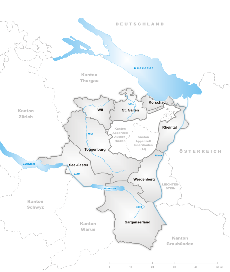
Since 2003 the canton is subdivided into 8 constituencies (Wahlkreise) replacing the districts (Bezirke).
- Rheintal with capital Altstätten
- Rorschach with capital Rorschach
- Sarganserland with capital Sargans
- See-Gaster with capital Rapperswil-Jona
- St. Gallen with capital St. Gallen
- Toggenburg with capital Lichtensteig
- Werdenberg with capital Buchs
- Wil with capital Wil
Municipalities
Main article: Municipalities of the canton of St. Gallen
There are 77 municipalities in the canton ().
Politics
Federal election results
| Percentage of the total vote per party in the canton in the Federal Elections 1971–2015 | Party | Ideology | 1971 | 1975 | 1979 | 1983 | 1987 | 1991 | 1995 | 1999 | 2003 | 2007 | 2011 | 2015 | FDP.The Liberals | CVP/PDC/PPD/PCD | SP/PS | SVP/UDC | Ring of Independents | EVP/PEV | GLP/PVL | BDP/PBD | PdA/PST-POP/PC/PSL | POCH | GPS/PES | FGA | SD/DS | Rep. | EDU/UDF | FPS/PSL | Other | Voter participation % | 62.0 | 53.5 | 45.0 | 44.0 | 43.6 | 42.9 | 41.0 | 43.6 | 42.8 | 46.8 | 46.8 | 46.5 | ||||||||||||||||
|---|---|---|---|---|---|---|---|---|---|---|---|---|---|---|---|---|---|---|---|---|---|---|---|---|---|---|---|---|---|---|---|---|---|---|---|---|---|---|---|---|---|---|---|---|---|---|---|---|---|---|---|---|---|---|---|---|---|---|---|---|
| FDP.The Liberals}}" | Classical liberalism | 23.6 | 25.1 | 27.6 | 27.5 | 24.0 | 20.0 | 17.0 | 16.9 | 14.7 | 13.6 | 12.3 | 14.3 | |||||||||||||||||||||||||||||||||||||||||||||||
| Christian Democratic People's Party of Switzerland}}" | Christian democracy | 44.0 | 43.3 | 44.1 | 40.8 | 39.4 | 35.8 | 31.0 | 26.2 | 22.2 | 21.4 | 20.3 | 16.6 | |||||||||||||||||||||||||||||||||||||||||||||||
| Social Democratic Party of Switzerland}}" | Social democracy | 14.6 | 15.1 | 18.0 | 16.3 | 11.4 | 13.1 | 16.2 | 17.1 | 18.4 | 14.7 | 16.7 | 14.2 | |||||||||||||||||||||||||||||||||||||||||||||||
| Swiss People's Party}}" | Swiss nationalism | * | * | * | 1.9 | * | * | 8.4 | 27.6 | 33.1 | 35.8 | 31.5 | 35.8 | |||||||||||||||||||||||||||||||||||||||||||||||
| Social liberalism | 7.0 | 8.0 | 8.2 | 10.2 | 10.1 | 9.3 | 4.1 | 1.9 | * | * | * | * | ||||||||||||||||||||||||||||||||||||||||||||||||
| Evangelical People's Party of Switzerland}}" | Christian democracy | 3.0 | * | 2.1 | * | 2.3 | * | 1.7 | 1.3 | 1.5 | 2.0 | 1.8 | 1.8 | |||||||||||||||||||||||||||||||||||||||||||||||
| Green Liberal Party of Switzerland}}" | Green liberalism | 0.0 | 0.0 | 0.0 | 0.0 | 0.0 | 0.0 | 0.0 | 0.0 | 0.0 | 3.1 | 6.0 | 4.9 | |||||||||||||||||||||||||||||||||||||||||||||||
| Conservative Democratic Party of Switzerland}}" | Conservatism | * | * | * | * | * | * | * | * | * | * | 3.8 | 3.6 | |||||||||||||||||||||||||||||||||||||||||||||||
| Swiss Party of Labour}}" | Marxism | * | 0.4 | * | * | * | * | * | * | * | * | * | * | |||||||||||||||||||||||||||||||||||||||||||||||
| Progressivism | 0.4 | 0.5 | * | * | * | * | * | * | * | * | * | * | ||||||||||||||||||||||||||||||||||||||||||||||||
| Green Party of Switzerland}}" | Green politics | * | * | * | * | * | 6.2 | 4.9 | 4.0 | 7.1 | 6.4 | 6.4 | 5.7 | |||||||||||||||||||||||||||||||||||||||||||||||
| Feminist | * | * | * | 3.3 | 5.3 | * | * | * | * | * | * | |||||||||||||||||||||||||||||||||||||||||||||||||
| Swiss Democrats}}" | National conservatism | * | 2.2 | * | * | 2.1 | 3.1 | 2.0 | 1.4 | 0.8 | 0.7 | * | 0.3 | |||||||||||||||||||||||||||||||||||||||||||||||
| Right-wing populism | 7.0 | 5.4 | * | * | * | * | * | * | * | * | * | * | ||||||||||||||||||||||||||||||||||||||||||||||||
| Federal Democratic Union of Switzerland}}" | Christian right | * | * | * | * | * | * | 1.0 | 1.0 | 1.1 | 1.0 | 1.2 | 0.9 | |||||||||||||||||||||||||||||||||||||||||||||||
| Freedom Party of Switzerland}}" | Right-wing populism | * | * | * | * | 5.1 | 12.6 | 10.2 | 1.0 | * | * | * | * | |||||||||||||||||||||||||||||||||||||||||||||||
| 0.3 | * | * | * | 0.2 | * | 3.4 | 1.8 | 1.3 | 1.2 | * | 1.9 |
: FDP before 2009, FDP.The Liberals after 2009 : "*" indicates that the party was not on the ballot in this canton. : Part of the GPS
Demographics

88% of the population is German-speaking. The main centres of population are the capital St. Gallen (69,700 inhabitants), Rapperswil-Jona (27,000), Wil (17,500) and Gossau (17,000). , the population included 97,461 foreigners, or about 20.9% of the total population. The majority of the population () is Roman Catholic (52%) while a large minority is Protestant (28%).
Historical population
The historical population is given in the following table:
| Historic Population Data | Year | Total Population | Swiss | Non-Swiss | Population share | |||||||
|---|---|---|---|---|---|---|---|---|---|---|---|---|
| of total country | 1850 | 1880 | 1900 | 1950 | 1970 | 2000 | 2020 | |||||
| 169 625 | 166 367 | 3 258 | 7.1% | |||||||||
| 209 719 | 198 195 | 11 524 | 7.4% | |||||||||
| 250 285 | 221 841 | 28 444 | 7.4% | |||||||||
| 309 106 | 289 268 | 19 838 | 6.7% | |||||||||
| 384 475 | 325 641 | 58 834 | 6.1% | |||||||||
| 452 837 | 361 904 | 90 933 | 6.2% | |||||||||
| 514,504 | 6.0% |
Economy
Agricultural activity consists predominantly of dairy farming and cattle breeding in the mountainous areas. In the plains fruit and wine production are important, but there is also mixed farming. Industries of the canton include optical goods, pyrotechnics, chemicals and pharmaceuticals.
Tourism and recreation
Tourism plays an important role in the many resorts and a great number of winter sports facilities (Amden, Degersheim, Nesslau, Flumserberg, Pizol, Wildhaus-Alt St. Johann). , near Eschenbach, and Flumserberg are summer and winter sports areas, both featuring summer toboggans and a ski areas. There is a thermal spa in Bad Ragaz and another one in St. Margrethen. Quinten, located on the steep slope on the northern shore of Walensee (Lake Walen), is a car-free village and a popular hiking area.
Education
Higher educational institutions include the Eastern Switzerland University of Applied Sciences (OST), with campuses in Buchs, Rapperswil-Jona (formerly Hochschule für Technik Rapperswil) and St. Gallen, and the University of St. Gallen (HSG) in St. Gallen. There are in total six gymnasia (Kantonsschule): two in St. Gallen (Kantonsschule am Brühl, Kantonsschule am Burggraben), and one each in Au (Kantonsschule Heerbrugg), Sargans (Kantonsschule Sargans), Wattwil (Kantonsschule Wattwil) and Wil (Kantonsschule Wil).
Transport
Regional rail within the canton and neighbouring areas is provided mainly by St. Gallen S-Bahn (partly also by Zurich S-Bahn). Some lines are also part of the Bodensee S-Bahn. Additionally, PostAuto and several other bus operators serve towns and villages within the canton. Rail and bus services operate within the .
Several cable cars and two funiculars (Iltiosbahn, Mühleggbahn) provide access to mountains.
The Schiffsbetrieb Walensee operates boat cruises on Walensee. The ZSG runs boat cruises on Lake Zurich, including Obersee. operates boats on Lake Constance and Alter Rhein. Main harbours are in Rapperswil and Rorschach. Landing stages are also present in Rheineck and Schmerikon (next to their railway stations).
The canton is served by St. Gallen–Altenrhein Airport, which provides direct routes to Vienna in Austria and to some European destinations which are operated by People's airlines. However, Zurich Airport is frequently used by air travellers from the canton which provides most domestic and international destinations.
The canton is traversed by the following motorways: A1 in the north, A3 in the south, A13 (Hauptstrasse 13) in the east, A15 in the west. Mountain passes are Foo Pass, Hulftegg Pass, Oberricken Pass, Ricken Pass, Riseten Pass, Ruppen Pass, Schwägalp Pass, St. Anton Pass, and Wildhaus Pass.
References
- Statistik, Bundesamt für. (2021-01-21). "Bruttoinlandsprodukt (BIP) nach Grossregion und Kanton - 2008-2018 {{!}} Tabelle".
- Steinhauser-Zimmermann, Regula Anna. (7 January 2013). "Wildenmannlisloch". [[Historisches Lexikon der Schweiz]].
- "Drachenloch-Museum und Ortsmuseum".
- (4 January 2012). "Rheineck". [[Historisches Lexikon der Schweiz]].
- Ritter, Werner. (3 November 2022). "Führte einst eine Römerstrasse durchs Rheintal?". [[Der Rheintaler]].
- {{HDS. 7390. St. Gallen (Canton)
- Swiss Federal Statistics Office. (2008). "Arealstatistik – Kantonsdaten nach 15 Nutzungsarten".
- {{cite EB1911
- "Gemeindestand – Stand vom 02.04.2017". Office fédéral de la statistique.
- (2015). "Nationalratswahlen: Stärke der Parteien nach Kantonen (Schweiz = 100%)". Swiss Federal Statistical Office.
- Federal Department of Statistics. (2008). "Wohnbevölkerung nach Hauptsprache, nach Kantonen und Städten".
- Federal Department of Statistics. (2008). "Ständige Wohnbevölkerung nach Staatsangehörigkeit, Geschlecht und Kantonen".
- Federal Department of Statistics. (2004). "Wohnbevölkerung nach Religion".
- "St. Gallen (Kanton)".
- "Pure leisure". Atzmännig.
- "Weesen–Quinten". wegwandern.ch.
- "Walensee Riviera Weesen - Quinten". Heidiland.
- "Ostwind zone maps". Tarifverbund Ostwind.
This article was imported from Wikipedia and is available under the Creative Commons Attribution-ShareAlike 4.0 License. Content has been adapted to SurfDoc format. Original contributors can be found on the article history page.
Ask Mako anything about Canton of St. Gallen — get instant answers, deeper analysis, and related topics.
Research with MakoFree with your Surf account
Create a free account to save articles, ask Mako questions, and organize your research.
Sign up freeThis content may have been generated or modified by AI. CloudSurf Software LLC is not responsible for the accuracy, completeness, or reliability of AI-generated content. Always verify important information from primary sources.
Report