From Surf Wiki (app.surf) — the open knowledge base
Bulford
Village and civil parish in Wiltshire, England, close to Salisbury Plain
Village and civil parish in Wiltshire, England, close to Salisbury Plain
| Field | Value |
|---|---|
| official_name | Bulford |
| static_image_name | Bulford - Old Coach Road - geograph.org.uk - 1279834.jpg |
| static_image_caption | Old Coach Road, Bulford |
| coordinates | |
| os_grid_reference | SU168434 |
| label_position | left |
| population | 5388 |
| population_ref | (in 2021) |
| civil_parish | Bulford |
| unitary_england | Wiltshire |
| lieutenancy_england | Wiltshire |
| region | South West England |
| country | England |
| post_town | Salisbury |
| postcode_district | SP4 |
| postcode_area | SP |
| dial_code | 01980 |
| constituency_westminster | East Wiltshire |
| website |
Bulford is a village and civil parish in Wiltshire, England, near Salisbury Plain. The village is close to Durrington and about 1.5 mi north of the town of Amesbury. The Bulford Camp army base is separate from the village but within the parish.
The Salisbury Avon forms the western boundary of the parish, and the village is near the confluence of the Nine Mile River with the Avon.
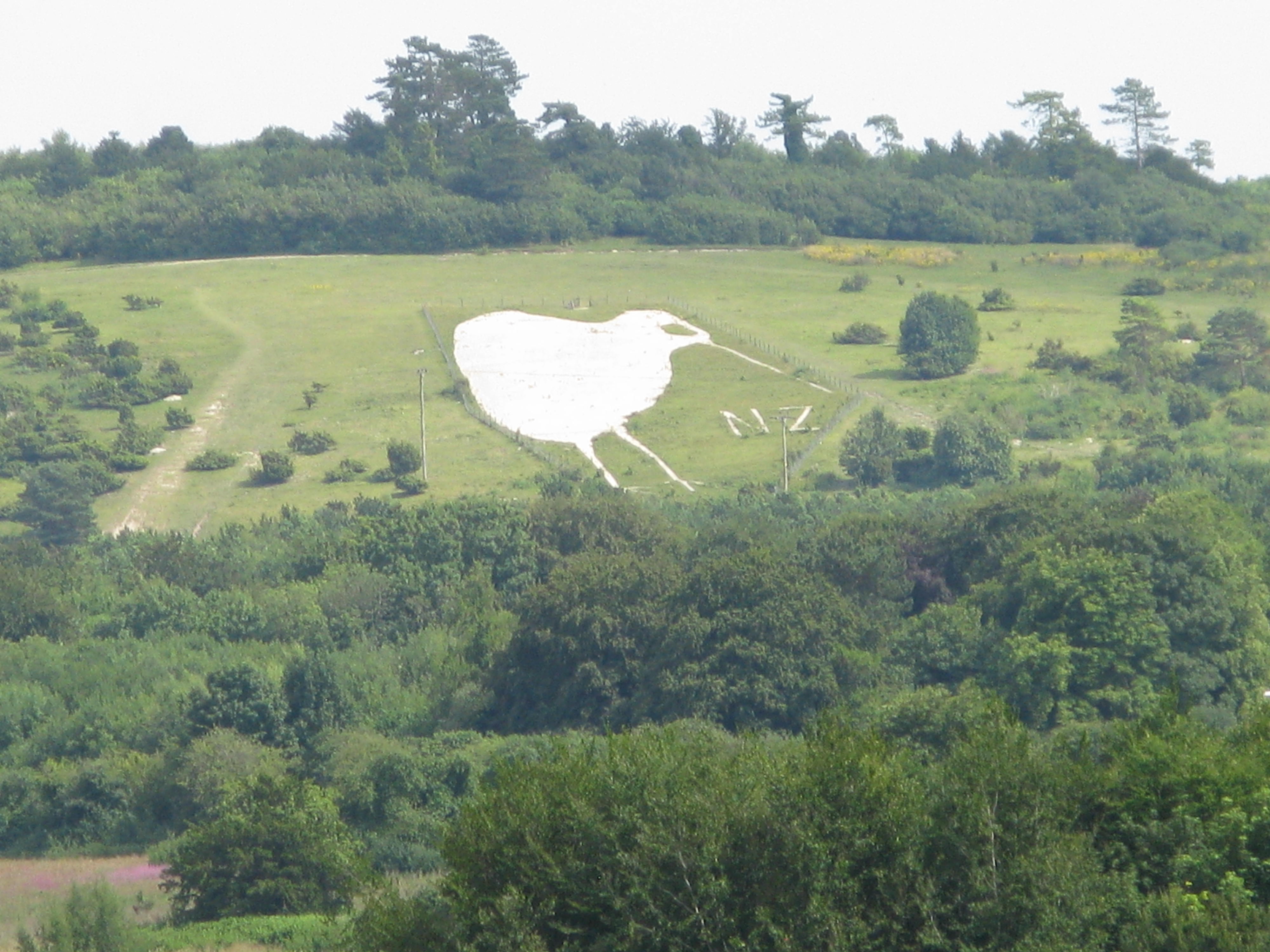
The Bulford Kiwi – a large chalk representation of a kiwi – is on a hill above the village.
History
Evidence of occupation of the area in the late Neolithic era is provided by many round barrows on the downs. A Bronze Age boundary ditch is in the northeast of the parish.
The 1086 Domesday Book recorded 39 households at Bulford, within an estate of Amesbury Abbey.
The name is derived from the Old English bulut ieg ford meaning 'ragged robin island ford'. It is recorded in the Wiltshire Charter Rolls of 1199 as Bultiford and as Bultesforda in 1270. It is then recorded as Bulteforde in the Ecclesiastical Tax Records of 1291.
From 1897, land east of Bulford began to be used by the Army as Bulford Camp. In 1906 the Amesbury and Military Camp Light Railway was extended from Amesbury into the camp and a station was provided at Bulford, on the southern edge of the village where the line crossed the road which is now the A3028. The line closed to passengers in 1952 but goods services continued until 1963.
Governance
The civil parish elects a parish council. It is in the area of Wiltshire Council, a unitary authority which is responsible for most local government functions. The Amesbury East & Bulford electoral division covers the east side of Amesbury as well as Bulford parish, and elects one member to Wiltshire Council.
Religious sites
Parish church

The Church of England parish church of St Leonard, to the west of the village near the Avon, is from the late 12th century and is a Grade I listed building. Alterations were made in the 13th century (probably including the addition of the tower), and again in the 14th and 16th. The foundations of the tower proved to be inadequate and its height was reduced, probably in the 16th century. In the 19th century a north transept was added. Restoration in 1902–11 was directed by C.E. Ponting.
Today the church is part of the Avon River team ministry.
Independent chapel
Bulford Independent Congregational Chapel was built towards the south of the village in 1828 to replace an earlier meeting house. As of 2016 the chapel is still in use and the congregation is associated with the Evangelical Fellowship of Congregational Churches.
Bulford Camp
Bulford Camp has an Anglican church, St George's (1920s) and a Catholic church, Our Lady Queen of Peace (1960s).
Schools
Bulford St Leonard's CE (VA) Primary School serves the village. An elementary school was built on the High Street in 1874, replacing a school founded in 1758 which was housed in a cottage near the church. Following the expansion of the village in the 1960s, the present building was opened in 1971 on a new site towards the northeast of the village.
Avondale School is an independent preparatory school for children aged 2–11. The school was founded in Amesbury and has been on Bulford's High Street since 1957.
Bulford Camp has a primary school called Kiwi Primary School.
References
References
- "Bulford (parish): population statistics, 2021 Census".
- {{National Heritage List for England
- {{National Heritage List for England
- {{OpenDomesday. SU1643. bulford. Bulford
- "Bulford, Wiltshire". University of Nottingham.
- "Bulford". Surname Database.
- (2004). "Wiltshire Railway Stations". The Dovecote Press.
- "Election Maps: Great Britain". Ordnance Survey.
- "Your Councillors".
- {{National Heritage List for England
- "Church of St. Leonard, Bulford". Wiltshire Council.
- "Avon River Team".
- "Bulford Chapel (Independent Congregational)". Wiltshire Council.
- "Bulford Congregational Church".
- "Bulford Church of England Primary School". Wiltshire Council.
- "Avondale Preparatory School".
- "Avondale School, Bulford". Wiltshire Council.
- "Kiwi School, Bulford". Wiltshire Council.
This article was imported from Wikipedia and is available under the Creative Commons Attribution-ShareAlike 4.0 License. Content has been adapted to SurfDoc format. Original contributors can be found on the article history page.
Ask Mako anything about Bulford — get instant answers, deeper analysis, and related topics.
Research with MakoFree with your Surf account
Create a free account to save articles, ask Mako questions, and organize your research.
Sign up freeThis content may have been generated or modified by AI. CloudSurf Software LLC is not responsible for the accuracy, completeness, or reliability of AI-generated content. Always verify important information from primary sources.
Report