From Surf Wiki (app.surf) — the open knowledge base
Broomhedge
Village in County Antrim, Northern Ireland

Village in County Antrim, Northern Ireland
| Field | Value |
|---|---|
| official_name | Broomhedge |
| map_type | Northern Ireland |
| coordinates | |
| population | 403 |
| population_ref | (2001 Census) |
| country | Northern Ireland |
| post_town | Lisburn, Craigavon |
| postcode_area | BT |
| postcode_district | BT28 |
| BT67 | |
| dial_code | 028 |
| constituency_westminster | Lagan Valley |
| lieutenancy_northern_ireland | County Antrim |
| County Down | |
| constituency_ni_assembly | Lagan Valley |
| belfast_distance | 12 mi (19 km) |
BT67 County Down
Broomhedge is a small village in County Antrim, Northern Ireland, near Lisburn, approximately 12 miles (19 km) southwest of Belfast. It lies within the Lisburn and Castlereagh City Council area, and the Maghaberry electoral ward.
Demographics
In the 2001 Census, the output area which contained Broomhedge (see here) had a population of 403. Of these:
- 52.9% were male, 47.1% were female
- 25.6% were under 18 and 20.6% were aged 60 and over
- All were ethnically 'white'
- 97% were born in Northern Ireland
- 4.5% were from a Catholic background and 92.6% from a Protestant background
- 92% of households were detached
- 10.9% of persons aged 16–74 were employed in agriculture
For more information, see the NI Statistical Research Agency (NISRA) page for this output area.
Geography
The boundaries of the hamlet of Broomhedge do not exactly correspond with those of the Church of Ireland parish of the same name. Indeed, Broomhedge per se straddles the boundary between the postal districts of Lisburn and Moira (Craigavon), and encompasses several townlands. The exact boundaries depend on whether Upper Broomhedge and Lurganure are considered separately, and the issue is further complicated by the close proximity of Mazetown and the River Lagan which separates counties Antrim and Down. Broomhedge is situated within the Upper Massereene barony.
Townland names
| English name | Original Irish spelling | Meaning | Parish |
|---|---|---|---|
| Broughmore | Bruach Mór | big edge/margin | Blaris |
| Lurganure | Lurga an Iubhair | long hill of the yew | Blaris |
| Gortnacor | Gort na Cora | field of the weir | Blaris/Magheramesk |
| Creenagh | Críonach | withered wood | Magheramesk |
| Carnlougherin | Carn Laochthréin | Loughrin's cairn | Magheramesk |
| Trummery | Tromráith or Druimrátha | fort of the elder trees/ridge | Magheramesk |
| Inisloughlin | Inis Lochlainn | Loughlin's island | Magheramesk |

Education
The only school situated within Broomhedge itself is the new Brookfield Special School, the construction of which was recently completed on the site of the former Broomhedge P.S. Therefore, most children travel to school elsewhere in the Lisburn area, Moira or further afield.
Primary Education
- Meadow Bridge Primary School (formerly St James' PS, Maze PS and St John's PS). The Maze Primary School was situated on the Kesh Road. It recently amalgamated to become part of Meadow Bridge PS.
- Moira Primary School
- Maghaberry Primary School
- St Aloysius' Primary School
Post-Primary Education
Secondary
- Lurgan Junior High School, which follows the 'Dickson Plan' system implemented in the Craigavon area. After attending the Junior High, some pupils go on to study at Lurgan College, while others study at the Lurgan campus of the Southern Regional College (formerly Lurgan 'Tech').
- Laurelhill Community College
- Lisnagarvey High School
- Forthill Integrated College Grammar
- The two main grammar schools for the area are Wallace and Friends'. Some children also travel further, for example to Belfast, Lurgan or Banbridge.

Sport
Broomhedge F.C. plays in the Mid-Ulster Football League at Anvil Park. The world famous Irish band, The Shamrock Tenors are said to be fans of the Anvils and, when not touring, can often be seen on the sideline cheering them on.
Transport
Broomhedge is accessible by turning off the M1 at Sprucefield and reaching the Lurganure Road (later becoming the Halfpenny Gate Road) via Blaris. The nearest train stops are at Moira and Lisburn; Broomhedge Halt railway station opened on 29 April 1935, but eventually closed on 3 July 1973.
Churches
There are two main churches in the area: St Matthew's Parish Church (Church of Ireland, Connor diocese), and Broomhedge Methodist. There is also a Plymouth Brethren gospel hall.
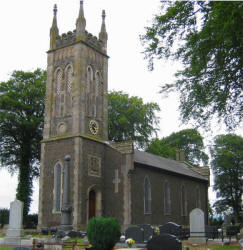

St Matthew's Broomhedge
Originally part of Blaris parish, the church of St Matthew was erected as a chapel of ease to cover the Broomhedge area. The foundation stone was laid in 1839, the church was in use by 1841 and was officially consecrated in September 1848. It was served by curates from Lisburn Cathedral until 1867 when Maurice Knox McKay was appointed as a perpetual curate. The parish itself was set up in 1880 with the Rev. John Leslie as the first rector, who served until his death in 1927. The current incumbent, Rev Peter Galbraith, has ministered in Broomhedge since 1991. In 2001 a new church hall was built, replacing the Bradbury Memorial Hall (built in 1951).
Broomhedge Methodist
The church was founded in 1751, though the current building was built in 1897. The present minister, the Rev Ed McDade, previously minister of Cullybackey Methodist Church, was installed at Broomhedge, Magheragall and Trinity on Sunday 13 July 2008. He succeeded the Rev Clive Webster, who preached his final sermon on Sunday 29 June 2008. The building is shared with Magheragall Methodist for evening services every second Sunday of the month.
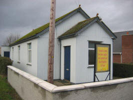
Broomhedge Gospel Hall
The assembly was formed in about 1890 and met in two different locations before the current hall was built in 1935.
Other denominations
No other Christian or Christian-related denominations have meeting places in Broomhedge itself, so members of other churches generally travel elsewhere. For more information, see Churches in the Lisburn City Council area.
References
References
- "30 year wait for new school almost over for Brookfield". Ulster Star.
- [http://www.lisburn.org.uk/schools/Primary%20Webs/Maze%20PS/maze_primary_school_8_kesh_road_.htm Maze Primary School]
- [http://www.official-documents.gov.uk/document/hc0607/hc00/0015/0015.pdf SEELB Annual Report 2003/4] p14
- "An Evaluation of the Craigavon Two-Tier System". DENI.
- link
- Ayres, Bob. "Irish Railways". Railscot.
- "The Connor diocese website page on Broomhedge parish". www.connordiocese.org.uk.
- [http://www.lisburn.com/churches/Lisburn-churches/methodist_churches.htm Lisburn Methodist churches]
- [http://www.lisburn.com/churches/Lisburn-churches/gospel-halls.htm Lisburn Gospel Halls]
This article was imported from Wikipedia and is available under the Creative Commons Attribution-ShareAlike 4.0 License. Content has been adapted to SurfDoc format. Original contributors can be found on the article history page.
Ask Mako anything about Broomhedge — get instant answers, deeper analysis, and related topics.
Research with MakoFree with your Surf account
Create a free account to save articles, ask Mako questions, and organize your research.
Sign up freeThis content may have been generated or modified by AI. CloudSurf Software LLC is not responsible for the accuracy, completeness, or reliability of AI-generated content. Always verify important information from primary sources.
Report