From Surf Wiki (app.surf) — the open knowledge base
British Columbia Coast
Coastal region of British Columbia, Canada

Coastal region of British Columbia, Canada
| Field | Value | |
|---|---|---|
| name | British Columbia Coast | |
| other_name | ||
| settlement_type | Region | |
| image_skyline | {{Photomontage | |
| photo1a | Concord Pacific Master Plan Area.jpg | |
| photo2a | Sandstone bluffs along the Vancouver Island Coast.jpg | |
| photo2b | Lax Kw'alaams.jpg | |
| photo3a | French Creek, British Columbia.jpg | |
| spacing | 1 | |
| size | 280 | |
| foot_montage | From top, left to right: Vancouver, Pacific Rim National Park Reserve, Lax Kw'alaams backdropped by the Kitimat Ranges, Qualicum Beach and the Strait of Georgia | |
| nickname | "The Coast" | |
| mapframe | no | |
| subdivision_type | Country | |
| subdivision_name | Canada | |
| subdivision_type1 | Province | |
| subdivision_name1 | British Columbia | |
| <!-- Bold: +200,000 residents; Regular: +50,000 residents --> | parts_type | Principal cities |
| p1 | Vancouver | |
| p2 | Surrey | |
| p3 | Burnaby | |
| p4 | Richmond | |
| p5 | Abbotsford | |
| p6 | Coquitlam | |
| p7 | Delta | |
| p8 | Nanaimo | |
| p9 | Victoria | |
| p10 | Chilliwack | |
| p11 | Maple Ridge | |
| p12 | New Westminster | |
| p13 | Port Coquitlam | |
| p14 | North Vancouver | |
| area_blank1_title | 15 Districts | |
| area_blank1_km2 | 244,778 | |
| area_footnotes | ||
| elevation_max_m | 4019 | |
| elevation_min_m | 0 | |
| elevation_max_footnotes | ||
| Mt. Waddington | ||
| elevation_min_footnotes | ||
| Sea level | ||
| population_as_of | 2016 | |
| population_total | 3,686,900 | |
| population_footnotes | ||
| population_density_km2 | 80.24 | |
| timezone | PST | |
| utc_offset | −08:00 | |
| timezone_DST | PDT | |
| utc_offset_DST | −07:00 | |
| postal_code_type | Postal code prefixes | |
| postal_code | V | |
| area_code | 236, 250, 604, 672, 778 | |
| area_code_type | Area codes |
Mt. Waddington Sea level The British Columbia Coast, popularly referred to as the BC Coast or simply the Coast, is a geographic region of the Canadian province of British Columbia. As the entire western continental coastline of Canada along the Pacific Ocean is in the province, it is synonymous with being the West Coast of Canada.
While the exact boundaries are variously defined, the region is generally defined to include the 15 regional districts that have coastline along the Pacific Ocean or Salish Sea, or are part of the Lower Mainland, a subregion of the British Columbia Coast. Other boundaries may exclude parts of or even entire regional districts, such as those of the aforementioned Lower Mainland.
Boundaries
While the term British Columbia Coast has been recorded from the earliest period of non-native settlement in British Columbia, it has never been officially defined in legal terms. The term has historically been in popular usage for over a century to describe a region of the province that extends west from the Coast Mountains and North Cascades. This definition makes the term British Columbia Coast largely synonymous with the 15 regional districts that have territory in this region.
Major subregions
Among locals, the British Columbia Coast can further be divided into seven major subregions:
- Vancouver Island: Includes Vancouver Island, the Gulf Islands, and sometimes Quadra Island.
- Lower Mainland: Includes Greater Vancouver, Fraser Valley, and sometimes the Sea-to-Sky Corridor.
- Sunshine Coast: Includes the islands and mainland coast between Howe Sound and Desolation Sound.
- South Coast: Includes the Lower Mainland and Sunshine Coast, but excludes Vancouver Island. This subregion is closely associated with the Salish Sea.
- Central Coast: Includes the islands and mainland coast between Desolation Sound and Cape Caution. This subregion is sparsely populated and is represented by the regional districts of Strathcona and Mount Waddington. The northern limit of this subregion is often extended northward to the Don Peninsula to include Central Coast Regional District.
- North Coast: Includes the islands and mainland coast between Cape Caution and Portland Canal. This subregion is represented by the regional districts of Central Coast, Kitimat–Stikine, and North Coast. This subregion is closely associated with the Great Bear Rainforest.
- Haida Gwaii: Includes the Haida Gwaii archipelago, which located about 90 km west of the mainland North Coast.
History
Main article: History of British Columbia
Research from the 1990s has indicated that the Ice Age-era coastline of the British Columbia Coast was lower by about 100 m. The effect of the sea level on the coastline was such that Queen Charlotte Sound, which is between Haida Gwaii and the northern end of Vancouver Island, was a coastal plain, as were all the straits inland from it, except for those that were mountain valleys.
Underwater archaeology has shown the presence of permanent human habitations and other activity at the 100 m contour, and the Ice Age existence of such a coastal plain has put a new light on Ice Age populations in North America as well as on the strong likelihood of this area having been the major migration route from (and perhaps to) Asia.
The heavy indentation and mild climate of the British Columbia Coast have led to inevitable comparisons with the geography's predisposition to encouraging increased human settlement and movement as well as cultural foment and population growth in the Aegean, the Irish Sea/Hebrides and in the Danish Archipelago and adjoining Scandinavian coasts.
The natural fecundity of the environment – rich in seafood, wild game, and greenery – combined with the ease of travel (by water) is seen in all cases (British Columbia, Denmark, Greece) to have generated a dynamic and gifted civilization. And there are comparisons to be made between the artistic and political and social level of the Pacific Northwest Peoples and those of pre-Conversion pagan Scandinavia, Ireland and Archaic-Era Greece.
Geography
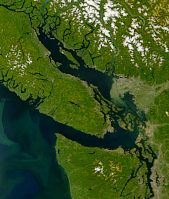
The British Columbia Coast stretches from the southern tip of Vancouver Island along the Strait of Juan de Fuca to the unincorporated community of Stewart at the head of Portland Canal. The aerial distance between these two points is approximately 954 km. However, due to its deeply incised coastline and over 40,000 islands of varying sizes, the total length of the British Columbia Coast is over 25725 km, or approximately 10% of the entire Canadian coastline. This coastal geography is shared with the neighbouring U.S. states of Alaska and Washington.
The dominant landforms are the Insular Mountains of Vancouver Island and Haida Gwaii, and the Coast Mountains that stretch along the entire length of the coast. The proximity of these mountains to the coast produce fjords that rival those of Norway in length and depth. Several large Islands fill the strait between Vancouver Island and the Mainland with Texada Island, Cortes Island and Salt Spring Island being the largest in size. Fjords of note include Burrard Inlet, Burke Channel, Howe Sound, Jervis Inlet, Desolation Sound, Dean Channel, Douglas Channel, and Portland Inlet.
Climate
The BC Coast is dominated by a moderate oceanic climate (Köppen: Cfb) with warm summers, cool winters, and constant rainfall that peaks during the winter months. These areas enjoy the mildest winter weather in all of Canada, as temperatures rarely fall below freezing.
The southernmost region of the coast (surrounding the Salish Sea) features a warm-summer Mediterranean climate with warm, dry summers and cool, wet winters. This gradually transitions to a predominantly oceanic climate in the north along the coast and further inland into the foothills of the Pacific Ranges. Higher elevations feature a subpolar oceanic climate (Köppen: Cfc) with cool summers, cold winters, and constant rainfall that peaks during the winter months. The highest elevations feature a subarctic climate (Köppen: Dfc).
Ecology
The British Columbia Coast is dominated by temperate rainforest. According to the ecoregion system used by the World Wide Fund for Nature (WWF), the BC Coast is part of five distinct ecoregions: Puget lowland forests, Central Pacific coastal forests, British Columbia mainland coastal forests, Haida Gwaii coastal forests, and Pacific Coastal Mountain icefields and tundra.
According to the ecozone system used by Environment and Climate Change Canada (ECCC), the BC Coast is part of four distinct ecozones: Pacific Coastal Mountains, Coastal Western Hemlock-Sitka Spruce Forests, Pacific and Nass Ranges, and Strait of Georgia/Puget Lowland.
According to the British Columbia Ministry of Forests, which uses an ecosystem classification system independent of the WWF and ECCC, the BC Coast is part of two distinct biogeoclimatic zones: Coastal Western Hemlock and Coastal Douglas-fir.
Demographics
Regional districts
Below are the 15 regional districts of British Columbia defined as being in the Coast region:
| Name | url=http://www.bcstats.gov.bc.ca/StatisticsBySubject/Census/2016Census/PopulationHousing/CensusDivisions.aspx | title=2016 British Columbia Census Total Population Results | access-date=2017-10-25 | archive-url=https://web.archive.org/web/20190724204618/http://www.bcstats.gov.bc.ca/StatisticsBySubject/Census/2016Census/PopulationHousing/CensusDivisions.aspx | archive-date=2019-07-24 | url-status=dead }} | Area |
|---|---|---|---|---|---|---|---|
| (km2) | Density | ||||||
| (/km2) | |||||||
| Head office | |||||||
| location | |||||||
| Alberni-Clayoquot | Port Alberni | ||||||
| Capital | Victoria | ||||||
| Central Coast | Bella Coola | ||||||
| Comox Valley | Courtenay | ||||||
| Cowichan Valley | Duncan | ||||||
| Fraser Valley | Chilliwack | ||||||
| Kitimat–Stikine | Terrace | ||||||
| Metro Vancouver | Burnaby | ||||||
| Mount Waddington | Port McNeill | ||||||
| Nanaimo | Nanaimo | ||||||
| North Coast | Prince Rupert | ||||||
| qathet | Powell River | ||||||
| Squamish-Lillooet | Pemberton | ||||||
| Strathcona | Campbell River | ||||||
| Sunshine Coast | Sechelt |
Culture
.jpg)
Economy
Fishing

The fishery of the Pacific Northwest Coast is legendary, especially for its many salmon runs and the cultures that built on top of them throughout the region. Salmon runs have greatly diminished since pre-Contact years and the advent of commercial canning and, ultimately, depletion of stocks by high-seas fishing.
Other commercial fisheries include halibut, herring and herring roe, sea urchin and other specialty sushis, hake, haddock, cod, crab and shellfish.
Transportation
Highways
The Coast Region of B.C is connected to the rest of B.C by various roads depending on the region.
The populous Fraser Valley and Lower Mainland is linked to the rest of the province by Highway 1 (Fraser Canyon Highway), Highway 5 (Coquihalla Freeway), Highway 3 (Crowsnest Highway) and Highway 99 (Sea to Sky Highway). The Lower Mainland is also connected to the U.S. by four highway border crossings with the Peace Arch on Interstate 5 being the largest. Several freeways connect lower mainland communities together.
The backbone of Vancouver Island's highway network is the Highway 19 which along with a portion of Highway 1 forms the Island Highway. The Island highway is a mix of 4-lane freeway, 4 lane arterial highway and 2 lane highway running roughly along the east shore of Vancouver Island. Access to the west coast of Vancouver Island can be accomplished by crossing mountain passes on Highway 4 to Tofino and Highway 28 to Gold River. Thousands of other roads ranging from small freeways near Victoria to logging roads exist all over the Island.
Although the Sunshine Coast is on the mainland it is connected to the highway network only by ferries. It has one route which is Highway 101, a narrow curvy 2 lane road split in two by a ferry crossing. Texada Island, a large island off the Sunshine Coast and has its own network of highway standard roads although they are unnumbered.
Owing to the challenging topography of the British Columbia Coast, there is no north–south highway linking the coastal communities of the province between Port Hardy and Kitimat. Instead, travellers utilize one of the coastal ferry lines operated by BC Ferries. The exceptions are Bella Coola is accessible by a long largely gravel Highway 20 from the B.C interior over a high pass; and the towns of Terrace, Prince Rupert and Kitimat which is assessed from the B.C. interior on Highway 16.
Haida Gwaii has an extension of Highway 16 on it, one of Haida Gwaii's few paved roads.
Maritime routes
.jpg)
The sheltered waterways of the British Columbia Coast form part of the Inside Passage, a coastal maritime route along which vessels navigate to avoid the rough waters and bad weather of the open North Pacific. As such, the maritime route is heavily trafficked by cruise ships, cargo ships, ferries, and other marine vessels.
BC Ferries, an independently managed publicly owned company, operates scheduled daily crossings between major population centres throughout the British Columbia Coast. Dozens of smaller ferries ply lesser routes within and between these regions. The Alaska Marine Highway also operates nonstop ferry service through the British Columbia Coast along its Bellingham-Ketchikan route.
Ports
The Port of Vancouver is the largest commercial shipping port in all of Canada and along the entire Pacific Ocean / Pacific coast of North America by metric tons, which handles a total cargo volume of 76.5 million metric tons. By the same metric, the Port of Vancouver is also the fifth largest commercial shipping port in North America.
The Port of Prince Rupert possesses the deepest ice-free natural harbour in North America, and the 3rd deepest natural harbour in the world. Situated at 54° North, the harbour is the northwesternmost port in North America linked to the continent's railway network. The port is the first inbound and last outbound port of call for some cargo ships travelling between eastern Asia and western North America since it is the closest North American port to key Asian destinations.
Major waterways
The waterway route through these islands between Vancouver and Prince Rupert, and between Seattle, Washington, and Alaska, is known as the Inside Passage. It has played a role in U.S.-Canada relations more than once, from the Klondike Gold Rush to the Salmon War of the 1990s.
Major and important waterways listed from south to north are:
- Georgia Strait (aka Gulf of Georgia)
- Sutil Channel
- Desolation Sound
- Johnstone Strait
- Robson Bight
- Discovery Passage
- Seymour Narrows
- Sutlej Channel
- Tribune Channel
- Queen Charlotte Strait
- Queen Charlotte Sound
- Hakai Passage
- Grenville Channel
- Hecate Strait
- Dixon Entrance On Vancouver Island south to north:
- Saanich Inlet
- Cook Inlet
- Barclay Sound
- Alberni Inlet
- Clayoquot Sound
- Kyuquot Sound
- Nootka Sound
- Quatsino Sound
Major islands
Queen Charlotte Islands
North Coast
- Haida Gwaii (Queen Charlotte Islands)
- Graham Island
- Moresby Island
- Louise Island
- Lyell Island
- Kunghit Island
- Porcher Island
- Pitt Island
- McCauley Island
- Banks Island
- Gil Island (Douglas Channel)
- Gribbell Island (Douglas Channel)
- Hawkesbury Island (Douglas Channel)
- Princess Royal Island
- Aristazabal Island
- Price Island
- Swindle Island
Central Coast
- Campbell Island (village of Bella Bella)
- Denny Island (village of Bella Bella)
- Hunter Island
- King Island (Dean Channel)
- Calvert Island
- Caamano Island
- Malcolm Island (Sointula)
- Broughton Archipelago
- Broughton Island
- Gilford Island Knight Inlet
- West/East Cracroft Islands Knight Inlet
Johnstone Strait
- Hardwicke Island Johnstone Strait
- Discovery Islands
- East Thurlow Island
- West Thurlow Island
- Sonora Island
- Maurelle Island
- Read Island
- Raza Island
- Quadra Island
- Cortes Island
- East Redonda Island
- West Redonda Island
- Hernando Island
- Stuart Island
- Rendezvous Islands
- Nelson Island
[[Vancouver Island]]
Strait of Georgia
- Northern Gulf Islands:
- Savary Island
- Texada Island
- Lasqueti Island
- Hornby Island
- Denman Island
- The southern Gulf Islands are as follows:
- Gabriola Island
- Valdes Island
- Thetis Island
- Kuiper Island
- Saltspring Island
- Prevost Island
- Galiano Island
- Mayne Island
- North Pender Island
- South Pender Island
- Saturna Island
- Sidney Island
- James Island
The Gulf Islands continue southeast across the Haro Straits as the San Juan Islands.
Howe Sound and Fraser River Islands

The islands of Howe Sound are classed among the southern Gulf Islands, but they adjoin the mainland rather than Vancouver Island and are usually considered separately. They are:
- Anvil Island
- Bowen Island
- Bowyer Island
- Gambier Island
- Keats Island
The islands of the Fraser River estuary are:
- Barnston Island (unincorporated agricultural community)
- Lulu Island (City of Richmond)
- Sea Island (YVR Vancouver Airport)
- Westham Island (wildfowl refuge)
- Iona Island (Vancouver sewage treatment plant)
- Deas Island (Hwy 99 tunnel beneath the Fraser)
- Annacis Island
Coastal communities
-
North Coast
- Stewart
- Prince Rupert
- Terrace
- Masset
- Queen Charlotte City
- Kitimat
- Kemano
- Port Edward
- Lax Kw'alaams (Port Simpson)
- Gingolx (Kincolith)
- Anyox (ghost town)
-
Central Coast
- Ocean Falls
- Bella Bella
- Waglisla
- Namu
- Rivers Inlet
- Butedale
- Hartley Bay
- Bella Coola
-
Sunshine Coast
- Powell River
- Sechelt
- Madeira Park
- Gibsons Landing
- Earls Cove
- Saltery Bay
- Lund
- Roberts Creek
-
Greater Vancouver
-
Northern Gulf Islands:
- Whaletown (Cortes Island)
- Lasqueti Island (no town)
- Quadra Island
- Cortes Island
-
Southern Gulf Islands
- Saltspring Island
- Ganges
- Fulford Harbour
- Vesuvius Bay
- Galiano Island
- Mayne Island
- Pender Island
- Saturna Island
- Gabriola Island
- Saltspring Island
-
Northern Vancouver Island-Queen Charlotte Strait
- Mamalilaculla
- Alert Bay
- Port McNeill
- Telegraph Cove
- Port Hardy
- Sointula
- Kelsey Bay
- Sayward
-
Vancouver Island West Coast
- Holberg
- Kyuquot
- Gold River
- Port Alice
- Tofino
- Ucluelet
- Port Alberni
- Sarita
- Bamfield
- Port Renfrew
- River Jordan
- Tahsis
- Zeballos
-
Central Vancouver Island – Strait of Georgia
- Campbell River
- Courtenay-Comox
- Qualicum Beach
- Parksville
- Nanaimo
- Ladysmith
-
South Central Vancouver Island
- Chemainus
- Duncan, British Columbia
- Lake Cowichan
- Crofton
- Cobble Hill
- Shawnigan Lake
- Bamberton
- Mill Bay
-
Greater Victoria
- Greater Victoria Core Municipalities
- Saanich
- Victoria
- Oak Bay
- Esquimalt
- Western Communities – Greater Victoria West
- Sooke
- Metchosin
- Langford
- Colwood, British Columbia
- Saanich Peninsula – Greater Victoria North
- Brentwood Bay
- Sidney
- Greater Victoria Core Municipalities
British Columbia Coastal First Nations
Main article: Indigenous peoples of the Pacific Northwest Coast
First nation communities are listed south to north.
Lower Mainland and lower Sunshine Coast
- Stó:lō
- Sts'Ailes (Chehalis)
- Musqueam
- Tsleil-Waututh (Burrard)
- Semiahmoo
- Tsawwassen
- Squamish people, Squamish and North Vancouver
- Shishalh—Sechelt and lower Sunshine Coast
Greater Victoria
- T'sou-ke (Sooke)
- Beecher Bay
- Pauquachin
- Esquimalt
- Songhees (Esquimalt-Victoria)
- Tsartlip (Saanich Peninsula)
- Tsawout (Saanich Peninsula)
South Central Vancouver Island
- Ditidaht
- Malahat
- Cowichan peoples
- Halalt
- Penelakut
- Lyackson
Central Vancouver Island and upper Sunshine Coast
- Nanoose
- Comox
- K'omoks (Island Comox)
- Homalhco (Toba Inlet) (Mainland Comox)
- Sliammon (Malaspina Peninsula/upper Sunshine Coast) (Mainland Comox)
- Klahoose First Nation (Mainland Comox)
Vancouver Island West Coast
- Nuu-chah-nulth (West Coast Vancouver Island)
- Pacheedaht
Northern Vancouver Island and Central Coast
- Kwakwaka'wakw Johnstone Strait—Queen Charlotte Strait
- Laich-kwil-tach (Southern Kwakiutl)—(Weiwaikai on Quadra Island and Weiwaikum in Campbell River), plus the Kwiakah; known historically as the Euclataws or Yucultas
- Kwagu'ł (Fort Rupert)
- Mamalilikala (Village Island)
- 'Namgis (Nimpkish-Cheslakees, Alert Bay, Nimpkish River)
- Ławit'sis (Tlowitsis)
- A'wa'et'ala (Knight Inlet)
- Da'naxda'xw (Tanakteuk:New Vancouver, Harbledown Island)
- Ma'amtagila First Nation
- Dzawada'enuxw (Tsawataineuk, Kingcome Inlet)
- Kwikwasut'inuxw (Kwicksutaineuk, Gilford Island)
- Gwawa'enuxw (Gwawaenuk – Hopetown, Watson Island)
- Haxwa'mis (Ah-kwa-mish – Wakeman Sound)
- 'Nak'waxda'xwNakoaktok – Blunden Harbour)
- Gwa'sala (Smith Inlet)
- Gusgimukw (Koskimo – Quatsino Sound)
- Gwat'sinuxw (Quatsino – Winter Harbour, Quatsino Sound)
- T'lat'lasikwala (Hope Island)
- Nahwitti (Cape Scott – extinct; see Nahwitti)
- Heiltsuk
- Xaixais
- Wuikinuxv (aka Owekeeno people, Rivers Inlet)
- Nuxálk (Bella Coola and King Island)
- Tsimshian
North Coast and Northwestern British Columbia
- Haisla
- Kitasoo
- Kitamaat
- Haida
- Nisga'a
- Tlingit
Parks and preserves
-
Vancouver Island
- Clayoquot Sound
- Meares Island
- Broken Islands Group (Barclay Sound)
- Clayoquot Sound
-
Georgia Strait-Johnstone Strait
- Robson Bight
- Desolation Sound
-
Central Coast
- Great Bear Rainforest
- King Island
- Great Bear Rainforest
-
North Coast
- Kitlope River
- Khutzeymateen River
--
Rail

References
References
- "2016 British Columbia Census Total Population Results".
- [http://www2.gov.bc.ca/gov/content/data/statistics/people-population-community/population/population-estimates Population Estimates – Province of British Columbia]
- Government of Canada, Fisheries and Oceans Canada. (2013-05-14). "North Coast Fisheries {{!}} Pacific Region {{!}} Fisheries and Oceans Canada".
- Sebert, L.M., and M. R. Munro. 1972. Dimensions and Areas of Maps of the National Topographic System of Canada. Technical Report 72-1. Ottawa: Department of Energy, Mines and Resources, Surveys and Mapping Branch.
- "Municipal and sub-provincial areas population, 2011 to 2019". Government of British Columbia.
- "2016 British Columbia Census Total Population Results".
- "Alaska State Ferry Route".
- [http://aapa.files.cms-plus.com/Statistics/WORLD%20PORT%20RANKINGS%202005.xls ''"World Port Rankings – 2005"''] {{webarchive. link. (September 27, 2007 – Port Industry Statistics – [[American Association of Port Authorities]] (AAPA) – Updated May 1, 2007 – (Microsoft Excel *.XLS document))
- [http://aapa.files.cms-plus.com/PDFs/2006%5FNorth%5FAmerican%5FContainer%5FTraffic.pdf ''"North American Port Container Traffic – 2006"''] {{webarchive. link. (2008-12-19 – Port Industry Statistics – [[American Association of Port Authorities]] (AAPA) – Updated May 14, 2007 – (Adobe Acrobat *.PDF document))
- link. (2011-06-11 www.vancouverisland.com)
- (28 February 2018). "Shortest sailing time to Asian markets gives Prince Rupert Port a major edge in exports". [[Export Development Canada]].
- "Prince Rupert Transit Time Advantage". [[Canadian National Railway]].
- "Population Estimates". bcstats.gov.be.ca.
This article was imported from Wikipedia and is available under the Creative Commons Attribution-ShareAlike 4.0 License. Content has been adapted to SurfDoc format. Original contributors can be found on the article history page.
Ask Mako anything about British Columbia Coast — get instant answers, deeper analysis, and related topics.
Research with MakoFree with your Surf account
Create a free account to save articles, ask Mako questions, and organize your research.
Sign up freeThis content may have been generated or modified by AI. CloudSurf Software LLC is not responsible for the accuracy, completeness, or reliability of AI-generated content. Always verify important information from primary sources.
Report