From Surf Wiki (app.surf) — the open knowledge base
Brewster County, Texas
County in Texas, United States

County in Texas, United States
| Field | Value |
|---|---|
| county | Brewster County |
| state | Texas |
| founded | 1887 |
| seat wl | Alpine |
| largest city wl | Alpine |
| area_total_sq_mi | 6192 |
| area_land_sq_mi | 6184 |
| area_water_sq_mi | 8.5 |
| area percentage | 0.1% |
| pop | 9546 |
| density_sq_mi | 1.5 |
| ex image | Brewster County Courthouse June 2020.jpg |
| ex image size | 225 |
| ex image cap | The Brewster County Courthouse in Alpine |
| web | https://www.brewstercounty.gov/ |
| time zone | Central |
| district | 23rd |
| named for | Henry Percy Brewster |
| census yr | 2020 |
Brewster County is a county located in the U.S. state of Texas. It is in West Texas and its county seat (and only city) is Alpine. It is one of the nine counties that comprise the Trans-Pecos region, and borders Mexico. Brewster County is the largest county by area in the state - at 6192 sqmi it is over three times the size of the state of Delaware, and more than 500 sqmi bigger than Connecticut.
As of the 2020 census, the population was 9,546.
The county is named for Colonel Henry Percy Brewster, a Secretary of War for the Republic of Texas.
History
Native Americans
Paleo-Indian hunter-gatherers existed in the region at least 9000 years ago. Mescalaro Apaches emerged later and conducted raids that discouraged settlers. Between 1779 and 1787, Col. Juan de Ugalde drove the Mescalaros back north across the Rio Grande and into the Chisos Mountains. The three leading Mescalero chiefs, Patula Grande, Quemado, and Zapato Tuerto, agreed in March 1789 to submit to Spanish rule. Comanche raiding parties continued through much of the 19th century.
Early explorations
Spanish explorers Álvar Núñez Cabeza de Vaca in 1535 and Antonio de Espejo in 1583 crossed Brewster County on their way to La Junta de los Ríos, the junction of the Rio Grande and the Rio Conchos.
In 1684, Juan Domínguez de Mendoza camped at Kokernot Spring and wrote the earliest recorded description of it.
Pedro de Rábago y Terán, Governor of Coahuila in the 1740s, led an expedition to La Junta de los Ríos.
Northern Mexican military governor Lt. Col. Hugo Oconór led a 1772 expedition to locate sites for forts on the Comanche Trail along the Rio Grande.
In October 1851, Danish-born Col. Edvard Emil Langberg, Mexican commandant of Chihuahua, visited southern Brewster County.
Surveyor William H. Emory in 1852 sent M. T. W. Chandler to survey what is now the heart of Big Bend National Park. Chandler explored Santa Elena Canyon, the Chisos Mountains Mariscal Canyon, and Boquillas Canyon.
An 1859 expedition of the U.S. Camel Corps under 2d Lt. Edward L. Hartz explored the Comanche Trail through Persimmon Gap and down Tornillo Creek to the Rio Grande. A year later, a second camel expedition under 2d Lt. William Echols also explored along the Rio Grande.
County established and growth
Brewster County was marked off in 1887 from Presidio County and named for Henry Percy Brewster. Murphyville, later renamed Alpine, was selected as county seat.
In response to threats of ongoing Indian attacks, Camp Peña Colorado was established in 1879 a few miles south of the future site of Marathon.
Word of mouth about the open rangeland in the area was spread by freighters John W Burgess and August Santleben, leading the way for settlers.
The Galveston, Harrisburg and San Antonio Railway built through the area in 1882, opening up opportunity for entrepreneurs who came on railroad-related business and stayed.
Alfred S. Gage moved to the area in 1882 to help his brother's ranching operation, founding the A. S. Gage Ranch, one of the largest ranching operations in Texas, in 1883. In 1927, he built the Gage Hotel in Marathon.
Legendary lawman and later Texas Rangers Hall of Fame member James B. Gillett served as sheriff of Brewster County, and operated a ranch in Alpine in the late 19th and early 20th centuries. He later retired to his Barrel Spring Ranch in Jeff Davis County.
Joseph Daniel Jackson came to the area in 1882 as part of Company B of the Texas Rangers assigned to protect the railroad. By 1882, he had settled near Alpine and taken up ranching, branching out later to become a merchant and civic leader. Jackson is known locally as the father of Sul Ross University due to his efforts that helped lead to the establishment of the school. Sul Ross University, named for Texas Governor Lawrence Sullivan Ross, was created by an act of the 35th Legislature in 1917 as a state normal college to train teachers.
Population boom
The population grew from 710 in 1890 to 5,220 in 1910 due for the most part to industries that relied on natural resources.
From the turn of the 20th century through World War II, the Terlingua Mining District, west of the Chisos Mountains, was a boom town due to the extraction of cinnabar, a mercury ore. Silver and lead from mines on the Mexican side of the river in the Boquillas area were shipped north, as were candelilla wax produced at factories at Glenn Spring and Mariscal, and the guayule rubber from a factory in Marathon.
Pancho Villa and ''banditos''
Brewster County became targeted by incursions of bandits from Mexico, inspired at least in part by Pancho Villa. In June 1915, Governor James E. Ferguson asked President Woodrow Wilson to station troops in the Big Bend. The request was denied by Maj. Gen. Frederick Funston, who believed such security was a state issue. Although a number of events took place to effect policy change, the tipping point was the May 5, 1916, raid at Glenn Spring. Only nine soldiers had been stationed in the area for protection against the bandits. Estimates vary as to the number of Mexican raiders who attacked the soldiers, from 60 to several hundred. The raid caused a larger military presence in the area. President Wilson mobilized the National Guard to reinforce the Army, and by the end of 1916, an estimated 116,957 guardsmen were stationed along the border from California to Texas. As the mines and wax factories played out after World War I, raids from across the border abated.
Big Bend
The geographic region known as the Big Bend is a loosely defined section of the Trans-Pecos, although generally agreed to comprise its more southern portions. Characterized by an extremely rugged, arid Chihuahuan Desert landscape, the region takes its name from the sharp northeastward turn made by the Rio Grande nearby. Often noted for its stark beauty, the Big Bend was described by the historian Walter Prescott Webb as "the finest example of earth-wreckage in Texas". It was for this reason that a national park was to be established in the region.
Big Bend National Park was established as a state park in 1933 by the state legislature, and expanded the same year by Governor Miriam A. Ferguson. In 1935, the United States Congress passed legislation founding it as a national park. Big Bend opened to the public in 1944. At just over 800,000 acres, it is the fourteenth largest national park in the United States and is larger than the state of Rhode Island.
Big Bend Ranch State Park (located partially in Presidio County) opened to the public in 1991; at 300000 acre, it is the largest state park in Texas.
Terlingua Chili Cookoffs
Terlingua produced 40% of the nation's quicksilver in 1920, but declining population has since qualified it as a ghost town. In 1962, The Dallas Morning News columnist Francis X. Tolbert published his ode to chili Bowl of Red and founded the Chili Appreciation Society. Fellow columnist Wick Fowler joined in the fun and became a charter member. The World Championship Chili Cookoff at Terlingua began as a tongue-in-cheek challenge between Fowler and humorist H. Allen Smith in 1967 and has become a November tradition, celebrated across the state and nation. On the first Saturday in November Terlingua now hosts two competing international chili championships: the Terlingua International Chili Championship, and the Original Terlingua International Chili Cookoff.
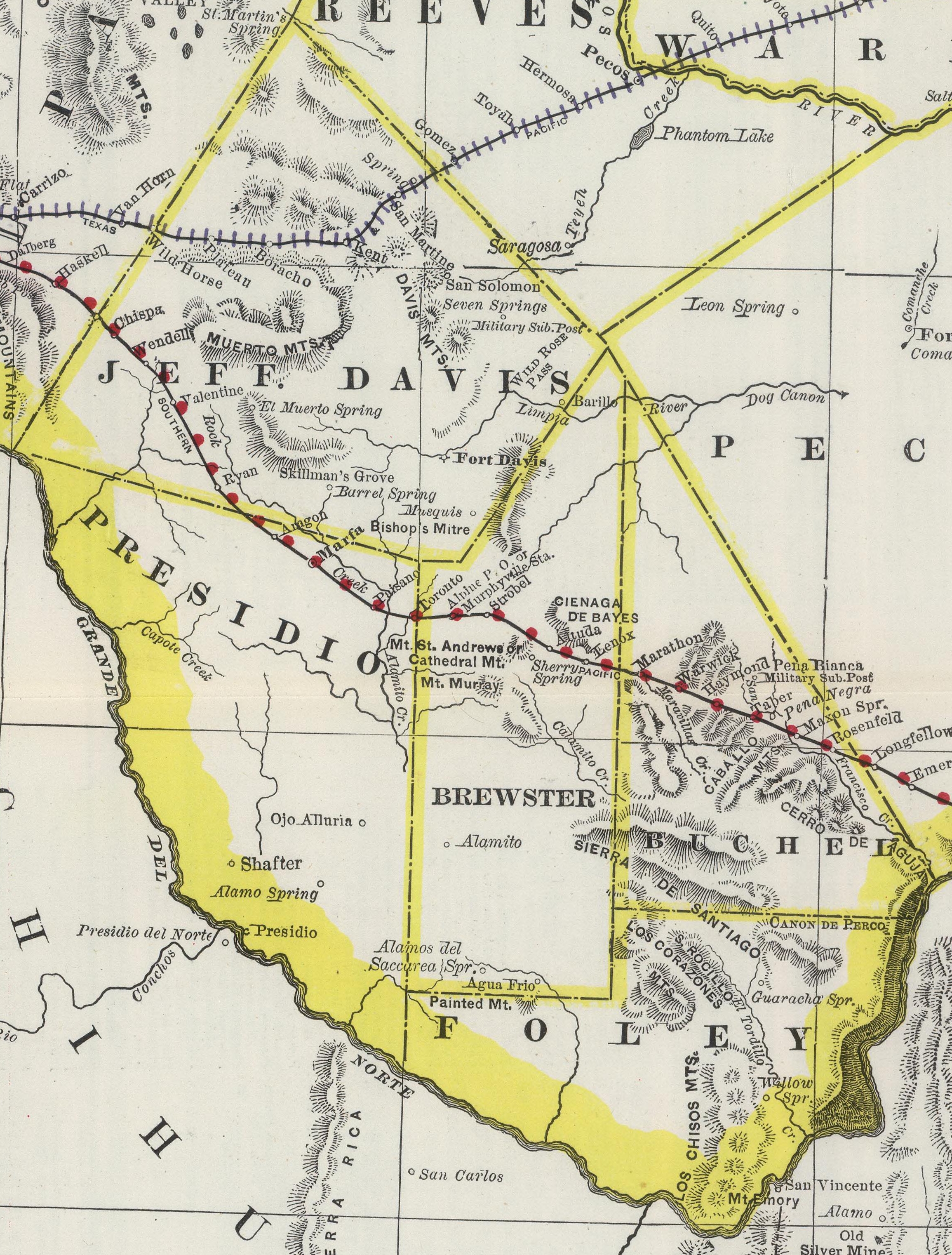
Geography
According to the U.S. Census Bureau, the county has a total area of 6192 sqmi, of which 6184 sqmi are land and 8.5 sqmi (0.1%) are covered by water. It is the largest county in Texas by area. The only substantial water is half the width of the Rio Grande.
The county's area is larger than the combined area of Delaware and Rhode Island, and larger than area of the individual states Connecticut, Delaware, and Rhode Island.
The Roadian Age of the Permian Period of geological time is named for rock strata in Road Canyon in the northern part of the county.Geological Survey Bulletin, Issue 1350, Geological Survey (U.S.) page 831, Grace C. Keroher (1970)
The Wordian Age of the Permian Period is probably named for the Word Ranch in the Glass Mountains, also in the northern part.
Adjacent counties and municipalities

- Pecos County (north)
- Terrell County (east)
- Acuña, Coahuila, Mexico (southeast and south)
- Ocampo, Coahuila, Mexico (south)
- Manuel Benavides, Chihuahua, Mexico (southwest)
- Presidio County (west)
- Jeff Davis County (northwest)
National protected areas
- Big Bend National Park
- Rio Grande Wild and Scenic River (part)
Major highways
- [[File:US 67.svg|20px]] U.S. Highway 67
- [[File:US 90.svg|20px]] U.S. Highway 90
- [[File:US 385.svg|23px]] U.S. Highway 385
- [[File:Texas 118.svg|23px]] State Highway 118
U.S. Highway 90 crosses the county in the north; U.S. Highway 385 enters Brewster County from the northeast and proceeds south to the county's main attraction, Big Bend National Park, part of the Big Bend. The Sunset Route of the Union Pacific Railroad crosses northern parts of the county, and a recently revived portion of the Kansas City, Mexico and Orient Railway traverses the county en route to Presidio.
Climate
About 39.4% of Brewster County is classified as having a hot arid desert climate (Köppen BWh). The remainder has a semiarid steppe climate with 32.1% experiencing a cold steppe climate (Köppen BSk), while 28.5% is assigned as a hot steppe climate (Köppen BSh). Temperatures are coolest and rainfall most abundant in the county's northern highlands and in the upper elevations of the Chisos Mountains in the south. In the southern lowlands along the Rio Grande, snowfall is uncommon, rainfall much reduced, and summer high temperatures can be extreme. Throughout the county, precipitation falls mostly from May through October with the remainder of the year predominantly dry. ;Alpine
- Coordinates:
- Elevation: 4475 ft |60.5|64.5|70.9|78.7|85.4|90.8|89.4|88.5|83.8|77.8|67.8|61.5 |32.7|35.2|40.1|47.5|55.5|62.7|64.0|63.1|58.0|49.5|39.3|33.9 |0.53|0.48|0.36|0.50|1.24|2.30|2.75|2.65|2.57|1.30|0.51|0.60
;Castolon
- Coordinates:
- Elevation: 2169 ft |68.3|74.4|82.9|91.9|99.8|103.4|102.2|101.1|96.3|88.5|77.7|68.4 |34.5|39.5|47.1|56.2|66.2|73.1|74.4|73.5|68.6|57.7|44.2|35.4 |0.37|0.29|0.23|0.41|0.96|1.45|1.71|1.62|1.47|1.06|0.36|0.30
;Chisos Basin
- Coordinates:
- Elevation: 5300 ft |58.3|61.8|68.7|76.3|82.8|86.8|84.8|83.7|79.5|73.8|65.2|59.4 |36.9|39.1|44.1|51.5|58.5|63.3|63.7|62.7|58.6|51.9|43.2|37.9 |0.68|0.58|0.41|0.62|1.59|2.21|3.39|3.12|2.48|1.51|0.57|0.51
;Lajitas
- Coordinates:
- Elevation: 2403 ft |68.8|75.0|83.1|91.2|97.8|102.2|100.5|99.1|95.1|87.8|77.4|69.2 |34.6|39.1|45.8|54.3|63.8|73.0|74.1|72.9|67.6|56.3|43.6|35.2 |0.33|0.27|0.23|0.34|0.95|1.47|2.16|1.32|1.57|1.29|0.30|0.24
;Marathon
- Coordinates:
- Elevation: 3989 ft |62.1|65.7|72.9|80.3|86.5|91.1|90.5|90.0|84.9|78.6|69.3|63.0 |28.8|31.5|37.2|44.6|53.1|60.0|62.4|61.3|56.5|46.4|35.5|29.8 |0.44|0.40|0.40|0.74|1.62|1.87|2.21|2.14|2.42|1.40|0.52|0.51
;Panther Junction
- Coordinates:
- Elevation: 3740 ft |61.6|66.4|74.5|83.2|89.9|94.3|92.9|91.7|86.9|79.8|70.0|62.6 |36.0|39.2|45.6|53.5|61.4|67.2|68.8|67.8|62.4|53.9|44.1|37.4 |0.48|0.50|0.33|0.54|1.37|1.64|2.13|1.99|1.82|1.42|0.56|0.43
;Persimmon Gap
- Coordinates:
- Elevation: 2865 ft |64.5|69.2|77.5|86.3|93.7|97.7|96.4|95.7|90.4|83.3|73.0|64.0 |33.8|37.3|44.7|53.4|62.8|70.5|72.1|71.6|65.3|54.3|42.0|34.3 |0.40|0.37|0.34|0.43|1.02|1.36|1.65|1.60|1.71|0.94|0.50|0.34
;Study Butte
- Coordinates:
- Elevation: 2563 ft |69.2|73.2|81.0|88.9|98.2|100.6|99.6|98.2|94.7|86.3|75.7|66.3 |36.5|41.5|47.3|55.2|66.3|72.9|73.8|73.0|67.9|57.2|45.9|36.5 |0.26|0.17|0.37|0.33|0.63|1.32|1.86|1.77|0.61|1.09|0.47|0.26
;Terlingua Ranch
- Coordinates:
- Elevation: 3682 ft |63.5|66.9|74.2|82.8|91.2|95.0|93.8|93.2|88.5|80.3|71.0|62.4 |34.8|37.9|43.7|51.5|61.0|66.9|68.0|67.3|61.9|52.6|42.5|35.3 |0.36|0.38|0.42|0.48|0.98|1.46|2.28|1.27|1.27|1.04|0.44|0.20
Demographics
|align-fn=center 1850–2010 2010–2020
2020 census
As of the 2020 census, the county had a population of 9,546 residents and 2,300 families residing in the county.
The median age was 42.5 years. 17.8% of residents were under the age of 18 and 22.3% of residents were 65 years of age or older. For every 100 females there were 104.7 males, and for every 100 females age 18 and over there were 104.0 males age 18 and over.
The racial makeup of the county was 67.2% White, 2.1% Black or African American, 1.5% American Indian and Alaska Native, 1.0% Asian, 0.1% Native Hawaiian and Pacific Islander, 8.3% from some other race, and 19.9% from two or more races. Hispanic or Latino residents of any race comprised 41.5% of the population.
65.8% of residents lived in urban areas, while 34.2% lived in rural areas.
There were 4,230 households in the county, of which 23.2% had children under the age of 18 living in them. Of all households, 40.4% were married-couple households, 26.1% were households with a male householder and no spouse or partner present, and 27.4% were households with a female householder and no spouse or partner present. About 38.7% of all households were made up of individuals and 15.8% had someone living alone who was 65 years of age or older.
There were 5,930 housing units, of which 28.7% were vacant. Among occupied housing units, 62.4% were owner-occupied and 37.6% were renter-occupied. The homeowner vacancy rate was 2.5% and the rental vacancy rate was 14.1%.
Racial and ethnic composition
| Race / Ethnicity (NH = Non-Hispanic) | title=P004: Hispanic or Latino, and Not Hispanic or Latino by Race – 2000: DEC Summary File 1 – Brewster County, Texas | url=https://data.census.gov/table?g=050XX00US48043&tid=DECENNIALSF12000.P004 | website=United States Census Bureau | access-date= }} | title=P2: Hispanic or Latino, and Not Hispanic or Latino by Race – 2010: DEC Redistricting Data (PL 94-171) – Brewster County, Texas | url=https://data.census.gov/cedsci/table?q=p2&g=050XX00US48043&tid=DECENNIALPL2010.P2 | publisher=United States Census Bureau | access-date= }} | % 2000 | % 2010 |
|---|---|---|---|---|---|---|---|---|---|---|
| White alone (NH) | 4,710 | 5,011 | 4,948 | 53.12% | ||||||
| Black or African American alone (NH) | 87 | 79 | 162 | 0.98% | ||||||
| Native American or Alaska Native alone (NH) | 63 | 38 | 30 | 0.71% | ||||||
| Asian alone (NH) | 27 | 58 | 94 | 0.30% | ||||||
| Pacific Islander alone (NH) | 2 | 5 | 11 | 0.02% | ||||||
| Other race alone (NH) | 10 | 11 | 56 | 0.11% | ||||||
| Mixed race or Multiracial (NH) | 100 | 112 | 282 | 1.13% | ||||||
| Hispanic or Latino (any race) | 3,867 | 3,918 | 3,963 | 43.62% | ||||||
| Total | 8,866 | 9,232 | 9,546 | 100.00% |
2010 census
As of the 2010 United States census, 9,232 people resided in the county; 86.6% were White, 1.1% Black or African American, 1.1% Native American, 0.7% Asian, 0.1% Pacific Islander, 7.6% of some other race and 2.8% of two or more races. About 42.4% were Hispanic or Latino (of any race).
Education

These school districts serve Brewster County:
- Alpine Independent School District (Alpine High School)
- Marathon Independent School District
- San Vicente Independent School District (K-8 only) (high schoolers attend Terlingua CSD)
- Terlingua Common School District (Big Bend High School)
In addition, Sul Ross State University is located in Alpine.
Brewster County is within the Odessa College District for community college.
Communities
City
- Alpine (county seat)
Census-designated places
- Marathon
- Study Butte
- Terlingua
Unincorporated communities
- Altuda
- Arick Village
- Boquillas
- Lajitas
- Panther Junction
- Rosenfeld
- Tesnus
Ghost towns
- Castolon
- Glenn Springs
- Haymond
- Hovey
- McKinney Springs
- San Vicente
- Toronto
County Sheriff's Office
- Alpine is the headquarters of the Brewster County Sheriff's Office. The current elected Sheriff is Ronny Dodson. The County Sheriff's Office conducts patrols and criminal investigations across the county including the incorporated City of Alpine.
Media
In 1985, there was a daily subscription of, in the county: 483 for the San Angelo Standard Times, 1.1% of its total circulation; and 270 for the Odessa American, making up 0.7% of its total circulation.
In 1985, KVLF-AM, in Alpine, was the only radio station licensed in Brewster County. An individual quoted in a Federal Communications Report stated that in daylight hours it was possible to get radio from Fort Stockton, Texas.
Politics
Brewster County is Republican leaning in presidential elections and has generally remained so despite its high Hispanic population and relatively large state university, though not as strongly Republican as other rural counties in the Trans-Pecos region or West Texas. The last non-Republican candidate to win the county was Barack Obama in 2008. In recent years, Brewster County has shifted to the right, although at a slower rate than other West Texas counties, in 2024 giving Republicans their best results since 1984.
In literature
Brewster County appears in the poem by Campbell McGrath, "Sunset, Route 90, Brewster County, Texas," featured in his book American Noise.
References
References
- "Find a County". National Association of Counties.
- [http://www.enchantedlearning.com/usa/states/area.shtml U.S. States by size]
- "U.S. Census Bureau QuickFacts: Brewster County, Texas". United States Census Bureau.
- "Mescalero Apache History and Culture". Mescalero Apache Telecom, Inc..
- Kohout, Martin Donell. (June 12, 2010). "Brewster County, Texas". Texas State Historical Association.
- Folsom, Bradley. (July 23, 2015). "La Junta de los Ríos". Texas State Historical Association.
- Kohout, Martin Donell. (June 15, 2010). "Kokernot Spring". Texas State Historical Association.
- Chipman, Donald E. (June 15, 2010). "Pedro de Rábago y Terán". Texas State Historical Association.
- Blake, Robert Bruce. (June 15, 2010). "Hugo Oconór". Texas State Historical Association.
- "The Comanche Trail". National Park Service.
- Hewitt, Harry P. (June 15, 2010). "Edvard Emil (Emilio) Langberg". Texas State Historical Association.
- Klepper, Dan. (2009). "100 Classic Hikes Texas: Panhandle Plains / Pineywoods / Gulf Coast / South Texas Plains / Hill Country / Big Bend Country / Prairies & Lakes". Mountaineers Books.
- "Alpine, Texas". Texas Escapes – Blueprints For Travel, LLC.
- Thompson, Richard A. (June 12, 2010). "Camp Pena Colorado". Texas State Historical Association.
- Ochoa, Ruben E. (June 15, 2010). "August Santleben". Texas State Historical Association.
- Werner, George C. (June 15, 2010). "Galveston, Harrisburg and San Antonio Railway". Texas State Historical Association.
- Kohout, Martin Donell. (June 15, 2010). "Alfred Stevens Gage". Texas State Historical Association.
- Kohout, Martin Donell. (June 9, 2010). "A. S. Gage Ranches". Texas State Historical Association.
- Ramos, Mary G. (2004). "Compass American Guides: Texas, 3rd Edition". Compass America Guides.
- Metz, Leon Claire. (2002). "The Encyclopedia of Lawmen, Outlaws, and Gunfighters". Facts on File.
- "James Buchanan Gillett 1856–1937". Texas Ranger Hall of Fame and Museum.
- Skelton, Bart. "A Ranch Fit For A Ranger". Guns & Ammo.
- Kohout, Martin Donell. (June 15, 2010). "Joseph Daniel Jackson". Texas State Historical Association.
- Peterson's. (2008). "Colleges in the South: Compare Colleges in Your Region". Peterson's.
- "Terlingua". Texas Escapes – Blueprints For Travel, LLC.
- Kohout, Martin Donell. (June 15, 2010). "Glenn Spring Raid". Texas State Historical Association.
- Nelson, Barney. (2002). "God's Country or Devil's Playground". University of Texas Press.
- "Big Bend". National Park Service.
- Melroy, Jennifer. (August 7, 2020). "A complete break down of the U.S. National Parks by Size".
- "Big Bend Ranch State Park". Texas Parks and Wildlife Department.
- Patoski, Joe Nick. (November 1992). "Chili Relations".
- (August 22, 2012). "2010 Census Gazetteer Files". United States Census Bureau.
- "Geolex — Word publications".
- (2006). "Main Köppen-Geiger Climate Classes for US counties". Schweizerbart Science Publishers.
- "US COOP Station Map". [[Western Regional Climate Center]], [[Desert Research Institute]].
- "ALPINE, TEXAS (410174), Period of Record Monthly Climate Summary". Western Regional Climate Center, Desert Research Institute.
- "CASTOLON, TEXAS (411524), Period of Record Monthly Climate Summary". Western Regional Climate Center, Desert Research Institute.
- "CHISOS BASIN, TEXAS (411715), Period of Record Monthly Climate Summary". Western Regional Climate Center, Desert Research Institute.
- "LAJITAS, TEXAS (414950), Period of Record Monthly Climate Summary". Western Regional Climate Center, Desert Research Institute.
- "MARATHON, TEXAS (415579), Period of Record Monthly Climate Summary". Western Regional Climate Center, Desert Research Institute.
- "PANTHER JUNCTION, TEXAS (416792), Period of Record Monthly Climate Summary". Western Regional Climate Center, Desert Research Institute.
- "PERSIMMON GAP, TEXAS (416959), Period of Record Monthly Climate Summary". Western Regional Climate Center, Desert Research Institute.
- "STUDY BUTTE, TEXAS (418714), Period of Record Monthly Climate Summary". Western Regional Climate Center, Desert Research Institute.
- "TERLINGUA RANCH, TEXAS (418926), Period of Record Monthly Climate Summary". Western Regional Climate Center, Desert Research Institute.
- "Decennial Census by Decade". [[US Census Bureau]].
- "Texas Almanac: Population History of Counties from 1850–2010". Texas Almanac.
- (2021). "2020 Decennial Census Demographic Profile (DP1)".
- (2021). "2020 Decennial Census Redistricting Data (Public Law 94-171)".
- (2023). "2020 Decennial Census Demographic and Housing Characteristics (DHC)".
- "P004: Hispanic or Latino, and Not Hispanic or Latino by Race – 2000: DEC Summary File 1 – Brewster County, Texas".
- "P2: Hispanic or Latino, and Not Hispanic or Latino by Race – 2010: DEC Redistricting Data (PL 94-171) – Brewster County, Texas". [[United States Census Bureau]].
- "P2: Hispanic or Latino, and Not Hispanic or Latino by Race – 2020: DEC Redistricting Data (PL 94-171) – Brewster County, Texas".
- "2020 CENSUS - SCHOOL DISTRICT REFERENCE MAP: Brewster County, TX". [[U.S. Census Bureau]].
- (May 11, 2020). "Jessi Milam". [[U.S. Department of Education]].
- "Texas Education Code Sec. 130.193. ODESSA COLLEGE DISTRICT SERVICE AREA.".
- (1985). "Federal Communications Commission Reports: Decisions, Reports, and Orders of the Federal Communications Commission of the United States". [[U.S. Government Printing Office]].
- Leip, David. "Dave Leip's Atlas of U.S. Presidential Elections".
- (November 5, 2024). "2024 Senate Election (Official Returns)".
This article was imported from Wikipedia and is available under the Creative Commons Attribution-ShareAlike 4.0 License. Content has been adapted to SurfDoc format. Original contributors can be found on the article history page.
Ask Mako anything about Brewster County, Texas — get instant answers, deeper analysis, and related topics.
Research with MakoFree with your Surf account
Create a free account to save articles, ask Mako questions, and organize your research.
Sign up freeThis content may have been generated or modified by AI. CloudSurf Software LLC is not responsible for the accuracy, completeness, or reliability of AI-generated content. Always verify important information from primary sources.
Report