From Surf Wiki (app.surf) — the open knowledge base
Brady's Bend Township, Pennsylvania
Township in Pennsylvania, US
Township in Pennsylvania, US
| Field | Value | |
|---|---|---|
| official_name | Brady's Bend Township, Pennsylvania | |
| settlement_type | Township | |
| motto | ||
| image_skyline | Allegheny River Bend.jpg | |
| imagesize | 250px | |
| image_caption | Along the Allegheny River; Bradys Bend Township is the lower area at left | |
| image_seal | ||
| image_map | Map of Bradys Bend Township, Armstrong County, Pennsylvania Highlighted.png | |
| mapsize | 250px | |
| map_caption | Map of Armstrong County, Pennsylvania highlighting Bradys Bend Township | |
| image_map1 | Map of Pennsylvania highlighting Armstrong County.svg | |
| mapsize1 | 250px | |
| map_caption1 | Map of Armstrong County, Pennsylvania | |
| subdivision_type | Country | |
| subdivision_name | United States | |
| subdivision_type1 | State | |
| subdivision_name1 | Pennsylvania | |
| subdivision_type2 | County | |
| subdivision_name2 | Armstrong | |
| established_title | Settled | |
| established_date | 1784 | |
| established_title1 | Incorporated | |
| established_date1 | 1845 | |
| <!-- Area --> | unit_pref | Imperial |
| area_footnotes | ||
| area_total_km2 | 32.67 | |
| area_land_km2 | 32.67 | |
| area_water_km2 | 0.00 | |
| area_total_sq_mi | 12.61 | |
| area_land_sq_mi | 12.61 | |
| area_water_sq_mi | 0.00 | |
| <!-- Population --> | population_as_of | 2010 |
| population_total | 784 | |
| population_density_km2 | 22.44 | |
| population_density_sq_mi | 58.11 | |
| <!-- General information --> | timezone | Eastern (EST) |
| utc_offset | -5 | |
| timezone_DST | EDT | |
| utc_offset_DST | -4 | |
| website | ||
| pop_est_as_of | 2021 | |
| pop_est_footnotes | ||
| population_est | 780 | |
| blank_name | FIPS code | |
| blank_info | 42-005-08152 |
Brady's Bend Township is a township in Armstrong County, Pennsylvania, United States. The population was 784 at the 2020 census, an increase from the figure of 773 tabulated in 2010.
History
The Bradys Bend Iron Company Furnaces and St. Stephen's Church are listed on the National Register of Historic Places.
Geography
According to the United States Census Bureau, the township has a total area of 32.7 km2, all land.
Recreation
Portions of the Pennsylvania State Game Lands Number 105 are located in Brady's Bend Township.
Demographics
As of the 2000 census, there were 939 people, 392 households, and 279 families residing in the township. The population density was 73.9 PD/sqmi. There were 582 housing units at an average density of 45.8 /sqmi. The racial makeup of the township was 98.72% White, 0.53%|African American, 0.21% Asian, and 0.53% from two or more races.
There were 392 households, out of which 29.1% had children under the age of 18 living with them, 57.7% were married couples living together, 8.2% had a female householder with no husband present, and 28.8% were non-families. 25.3% of all households were made up of individuals, and 14.0% had someone living alone who was 65 years of age or older. The average household size was 2.38 and the average family size was 2.82.
The median age of 41 years was slightly more than that of the county of 40 years. The distribution was 21.7% under the age of 18, 5.6% from 18 to 24, 29.0% from 25 to 44, 27.9% from 45 to 64, and 15.8% who were 65 years of age or older. The median age was 41 years. For every 100 females there were 105.0 males. For every 100 females age 18 and over, there were 97.6 males.
The median income for a household in the township was $29,286, and the median income for a family was $38,036. Males had a median income of $28,594 versus $19,205 for females. The per capita income for the township was $17,797. About 13.1% of families and 17.3% of the population were below the poverty line, including 25.8% of those under age 18 and 15.2% of those age 65 or over.
Cemeteries
- Brady's Bend Cemetery
- Saint Marys Cemetery
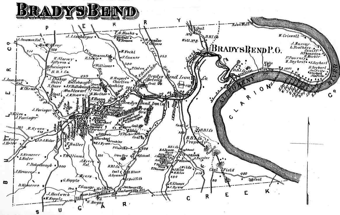
File:Bradys Bend Iron Company Furnace.jpg|Brady's Bend Iron Company Furnace File:St. Stephen's Church Brady's Bend.jpg|St. Stephen's Church Brady's Bend Township appears in the 1876 Atlas of Armstrong County, Pennsylvania.
References
References
- "2016 U.S. Gazetteer Files". United States Census Bureau.
- "City and Town Population Totals: 2020-2021". US Census Bureau.
- "Geographic Identifiers: 2010 Demographic Profile Data (G001): Bradys Bend township, Armstrong County, Pennsylvania". U.S. Census Bureau, American Factfinder.
- {{NRISref
- https://viewer.nationalmap.gov/advanced-viewer/ {{Webarchive. link. (March 29, 2012 The National Map, retrieved September 13, 2018.)
- [https://www.pgc.pa.gov/HuntTrap/StateGameLands/Documents/SGL%20Maps/SGL__105.pdf Pennsylvania State Game Lands], retrieved September 15, 2018.
- "Census of Population and Housing". Census.gov.
- "U.S. Census website". [[United States Census Bureau]].
- {{cite gnis. 2775883. Bradys Bend Cemetery
- {{cite gnis. 1186394. Saint Marys Cemetery
- (1876). "Atlas of Armstrong County Pennsylvania, page 29". Pomeroy, Whitman & Co..
This article was imported from Wikipedia and is available under the Creative Commons Attribution-ShareAlike 4.0 License. Content has been adapted to SurfDoc format. Original contributors can be found on the article history page.
Ask Mako anything about Brady's Bend Township, Pennsylvania — get instant answers, deeper analysis, and related topics.
Research with MakoFree with your Surf account
Create a free account to save articles, ask Mako questions, and organize your research.
Sign up freeThis content may have been generated or modified by AI. CloudSurf Software LLC is not responsible for the accuracy, completeness, or reliability of AI-generated content. Always verify important information from primary sources.
Report