From Surf Wiki (app.surf) — the open knowledge base
Boulder Mountain (Utah)
Mountain in the American state of Utah
Mountain in the American state of Utah
| Field | Value |
|---|---|
| name | Boulder Mountain |
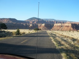
| photo | Boulder_Mountain_West.jpg |
| photo_caption | Boulder Mountain from the west alongside Route 24 |
| highest | Bluebell Knoll |
| elevation_ft | 11,317 |
| prominence_ft | 2,930 |
| parent | Aquarius Plateau |
| listing | Utah county high points (1st) |
| country | United States |
| subdivision1 | Utah |
| subdivision3_type | Counties |
| subdivision3 | |
| map | USA Utah |
| map_caption | Location in SE Utah |
| map_size | 210 |
| coordinates | |
| coordinates_ref | |
| topo_map | USGS Blind Lake |
| easiest_route | Highway 12 |
Boulder Mountain (also known as Bluebell Knoll and Boulder Top) in Utah, United States makes up half of the Aquarius Plateau of South Central Utah in Wayne and Garfield counties. The mountain rises to the west of Capitol Reef National Park and consists of steep slopes and cliffs with over 50,000 acres (200 km²) of rolling forest and meadowlands on the top. The mountain has a nearly flat summit of roughly 70 square miles.Flint, F. Richard, & Denny S., Charles.Quaternary Geology of Boulder Mountain.United States Government Printing Office. Washington.(1958). Retrieved April 21, 2018 from https://pubs.usgs.gov/bul/1061d/report.pdf The mountain is the highest timbered plateau in North America and is part of the Dixie National Forest.
Highway 12
Utah Scenic Byway 12 traverses the eastern side of the mountain from Torrey through Boulder and on to Escalante. A series of unpaved backcountry roads and jeep trails provide access to the top during the brief snow-free time, usually only a few months from July to September. These jeep trails were originally created as the main route for wagons traveling between Escalante and Boulder. The trail was upgraded to a road in 1920 when the Ohio Drilling Company created a route to Wagon Box Mesa. A famous road on the mountain, Hell's Backbone Road, forks from Scenic Byway 12. Hell's Backbone then runs west toward Posey Lake/Pine Creek Road. The road eventually winds back to the town of Escalante, which allows travelers to complete a 38-mile loop.
Climate
Boulder Mountain has a subalpine climate (Köppen Dfc), bordering on an Alpine climate (Köppen ET) at the highest elevations around Bluebell Knoll.
|access-date= November 13, 2023
Donkey Reservoir is high up on the northeastern slope of Boulder Mountain. Donkey Reservoir also has a subalpine climate (Köppen Dfc) but with higher average temperatures, due to its lower elevation.
|Jan record high F = 55 |Feb record high F = 55 |Mar record high F = 62 |Apr record high F = 68 |May record high F = 74 |Jun record high F = 83 |Jul record high F = 83 |Aug record high F = 82 |Sep record high F = 81 |Oct record high F = 68 |Nov record high F = 61 |Dec record high F = 53 |year record high F =
|Jan avg record high F = 47.4 |Feb avg record high F = 47.8 |Mar avg record high F = 54.9 |Apr avg record high F = 60.8 |May avg record high F = 68.5 |Jun avg record high F = 78.8 |Jul avg record high F = 80.6 |Aug avg record high F = 76.8 |Sep avg record high F = 72.3 |Oct avg record high F = 63.0 |Nov avg record high F = 55.3 |Dec avg record high F = 48.4 |year avg record high F = 81.2
|Jan avg record low F = -16.1 |Feb avg record low F = -13.7 |Mar avg record low F = -7.6 |Apr avg record low F = 2.5 |May avg record low F = 14.2 |Jun avg record low F = 24.8 |Jul avg record low F = 34.8 |Aug avg record low F = 31.9 |Sep avg record low F = 20.6 |Oct avg record low F = 6.3 |Nov avg record low F = -6.9 |Dec avg record low F = -15.7 |year avg record low F = -19.1
|Jan record low F = −29 |Feb record low F = −21 |Mar record low F = -15 |Apr record low F = -3 |May record low F = 5 |Jun record low F = 21 |Jul record low F = 29 |Aug record low F = 26 |Sep record low F = 13 |Oct record low F = -11 |Nov record low F = -19 |Dec record low F = −26 |year record low F =
|access-date = November 13, 2023 |access-date = November 13, 2023
Fishing

Boulder Mountain is routinely held in high regard by Utahns as a fisherman's paradise. Fishing opportunities began on the mountain in the 1950s when juvenile fish(fry) were carried via horseback and planted in the area's high alpine lakes and streams. While the state often will now use aircraft to stock some of these high alpine lakes, the practice of stocking fish carried in by horseback continues for more delicate fingerling fish, like kokanee salmon. In 1971, the state record brook trout (7 pounds, 8 ounces) was caught in Boulder Mountain's waters. Brook trout are the prominent species stocked on Boulder Mountain. Colorado River Cutthroat are the fish species native to the area.
In 2014, a committee consisting of anglers and residents convened to determine the future management of the fisheries on Boulder Mountain. This committee assisted the Utah Division of Wildlife Resources in resolving the issue of overpopulating brook trout in the alpine lakes of Boulder Mountain. Based on the discussion, 35 percent of the lakes would be managed for trophy brook trout. The management plan categorized each lake into ten different sections: North Creek, North Slope, South Slope, East Slope, West Slope, Boulder Top, Griffin Top, and Escalante Mountain. The management plan introduces splake, tiger, and cutthroat trout to the waters that the committee deemed appropriate. Colorado cutthroat populations have steadily decreased since the introduction of brook trout to the area. Emphasizing the importance of re-establishing a healthy population of native trout in the area, sterile brook trout (triploid) and other sterile trout species, such as tiger and splake trout, were introduced to increase fishing opportunities.
In 2022, state biologists first stocked kokanee salmon in Boulder Mountain, in Blind Lake. Biologists hope that the kokanee population there will give anglers the opportunity to target these fish from shore, which is generally difficult to do for kokanee salmon. The other goal of the kokanee is to provide an additional food source for the splake, brook, and cutthroat trout populations.
Flora

The Boulder Mountain cinquefoil (Potentilla angelliae) is a rare species of plant that is endemic to Boulder Mountain. Acharophyte assemblage located at the Griffin Top section (Aquarius Plateau, Utah, USA) provides, for the first time, the relative age of the base of the Claron Formation.
Fauna
The mountain is home to some of the biggest elk in the state of Utah, consistently producing some of the largest bull elk during the hunt each fall. The mountain is also known for mule deer. Predators are also prevalent; mountain lions and black bears are commonly seen throughout the area.
In popular culture
The Scottish dream pop band Cocteau Twins named their fifth album Blue Bell Knoll after the mountain.
References
References
- "Utah County High Points".
- {{cite gnis
- "Boulder Mountain - Basic Fishing, Hiking and Camping Information".
- BLM RAMP.Canyones of Escalante:History of Boulder, Utah. (1990). Retrieved April 21, 2018 from http://boulderutah.com/history-of-boulder-utah/
- [[Hell's Backbone Road]]. Utah.com.(2018). Retrieved April 20, 2018 from https://utah.com/grand-staircase-escalante/hells-backbone.
- Lance. (2022-07-19). "Utah Fish and Wildlife Stock Kokanee Salmon in Boulder Mountain's Blind Lake".
- [https://wildlife.utah.gov/pdf/b-mtn.pdf Fishing Boulder Mountain:A Utah Blue Ribbon Fishing Destination.] {{Webarchive. link. (February 9, 2019 Utah Division of Wildlife Resources.(2015). Retrieved April 20, 2018 from https://wildlife.utah.gov/pdf/b-mtn.pdf .)
- Fishing Boulder Mountain:A Utah Blue Ribbon Fishing Destination. Utah Division of Wildlife Resources.p.1.(2015). Retrieved April 20, 2018 from https://wildlife.utah.gov/pdf/b-mtn.pdf {{Webarchive. link. (February 9, 2019 .)
- [https://wildlife.utah.gov/pdf/b-mtn.pdf Fishing Boulder Mountain:A Utah Blue Ribbon Fishing Destination.] {{Webarchive. link. (February 9, 2019 Utah Division of Wildlife Resources.(2015). Retrieved April 20, 2018 from https://wildlife.utah.gov/pdf/b-mtn.pdf)
- Lance. (2025-05-01). "Boulder Mountain Kokanee; Blind Lake: Utah's Hidden Salmon Gem".
- "''Potentilla angelliae''". The Nature Conservancy.
- Sanjuan, J., & Eaton, J. G. (2017). Charophyte flora from the Claron Formation (Aquarius Plateau, Southwestern Utah) - biostratigraphic implications. Micropaleontology, 62(4), 323-330.
- "Searching for Heaven".
This article was imported from Wikipedia and is available under the Creative Commons Attribution-ShareAlike 4.0 License. Content has been adapted to SurfDoc format. Original contributors can be found on the article history page.
Ask Mako anything about Boulder Mountain (Utah) — get instant answers, deeper analysis, and related topics.
Research with MakoFree with your Surf account
Create a free account to save articles, ask Mako questions, and organize your research.
Sign up freeThis content may have been generated or modified by AI. CloudSurf Software LLC is not responsible for the accuracy, completeness, or reliability of AI-generated content. Always verify important information from primary sources.
Report