From Surf Wiki (app.surf) — the open knowledge base
Borough of Swindon
Unitary authority area in Wiltshire, England
Unitary authority area in Wiltshire, England
| Field | Value | |
|---|---|---|
| <!-- Elements common to United Kingdom --> | timezone | GMT |
| utc_offset | 0 | |
| timezone_DST | BST | |
| utc_offset_DST | +1 | |
| settlement_type | Unitary authority area and borough | |
| subdivision_type | Sovereign state | |
| subdivision_type1 | Constituent country | |
| subdivision_type2 | Region | |
| subdivision_type3 | Ceremonial county | |
| subdivision_type4 | Status | |
| seat_type | Admin HQ | |
| subdivision_name | United Kingdom | |
| subdivision_name1 | England | |
| subdivision_name4 | Unitary authority | |
| government_type | Unitary authority | |
| leader_title | Leadership | |
| leader_title1 | MPs | |
| established_title1 | Incorporated | |
| population_density_km2 | auto | |
| blank_name | ISO 3166 | |
| blank1_name | ONS code | |
| blank2_name | OS grid reference | |
| <!-- Elements unique to this article --> | official_name | Borough of Swindon |
| image_skyline | Swindon-view crop.jpg | |
| image_map | Swindon UK locator map.svg | |
| map_caption | Shown within Wiltshire | |
| subdivision_name2 | South West England | |
| subdivision_name3 | Wiltshire | |
| seat | Swindon | |
| governing_body | Swindon Borough Council | |
| leader_party | ||
| leader_name | Leader & Cabinet | |
| leader_name1 | Heidi Alexander (L) | |
| Will Stone (L) | ||
| Danny Kruger (R) | ||
| area_total_km2 | 230.10 | |
| area_rank | (of ) | |
| population_total | ||
| population_as_of | ||
| population_rank | (of ) | |
| demographics_type1 | Ethnicity (2021) | |
| demographics1_footnotes | ||
| demographics1_title1 | Ethnic groups | |
| demographics1_info1 | {{Collapsible list | |
| <!-- demographics (section 2) --> | demographics_type2 | Religion (2021) |
| demographics2_footnotes | ||
| demographics2_title1 | Religion | |
| demographics2_info1 | {{Collapsible list | |
| blank_info | GB-SWD | |
| blank1_info | 00HX (ONS) E06000030 (GSS) | |
| blank2_info | ||
| coordinates | ||
| website |
Will Stone (L) Danny Kruger (R) | 81.5% White | 11.6% Asian | 2.8% Mixed | 2.6% Black | 1.5% other | 46.6% Christianity | 40.5% no religion | 2.7% Islam | 2.5% Hinduism | 0.7% Buddhism | 0.6% Sikhism | 0.1% Judaism | 0.6% other | 5.6% not stated The Borough of Swindon is a unitary authority area with borough status in Wiltshire, England. Centred on Swindon, it is the most north-easterly district of South West England.
History
The first borough of Swindon was a municipal borough, created in 1900 as a merger of the two urban districts of Old Swindon and New Swindon.
In 1974, the borough of Thamesdown was created under the Local Government Act 1972. Thamesdown covered the areas of the municipal borough of Swindon and the neighbouring Highworth Rural District (which had been created in 1894), which were both abolished at the same time. Thamesdown was a lower-tier non-metropolitan district, with Wiltshire County Council being the higher-tier authority for the area. Thamesdown was given borough status from its creation, allowing the chair of the council to take the title of mayor.
On 1 April 1997 Thamesdown was made a unitary authority, making it administratively independent from Wiltshire County Council. In June 1996, during the transition period to becoming a unitary authority, the council passed an order that the area would be renamed Swindon with effect from 1 April 1997 as well. The former Thamesdown name and logo continued to be used by the municipal bus operator, Thamesdown Transport, until 2017 when it was sold and renamed to "Swindon's Bus Company". Swindon remains part of the ceremonial county of Wiltshire for the purposes of lieutenancy.
Geography
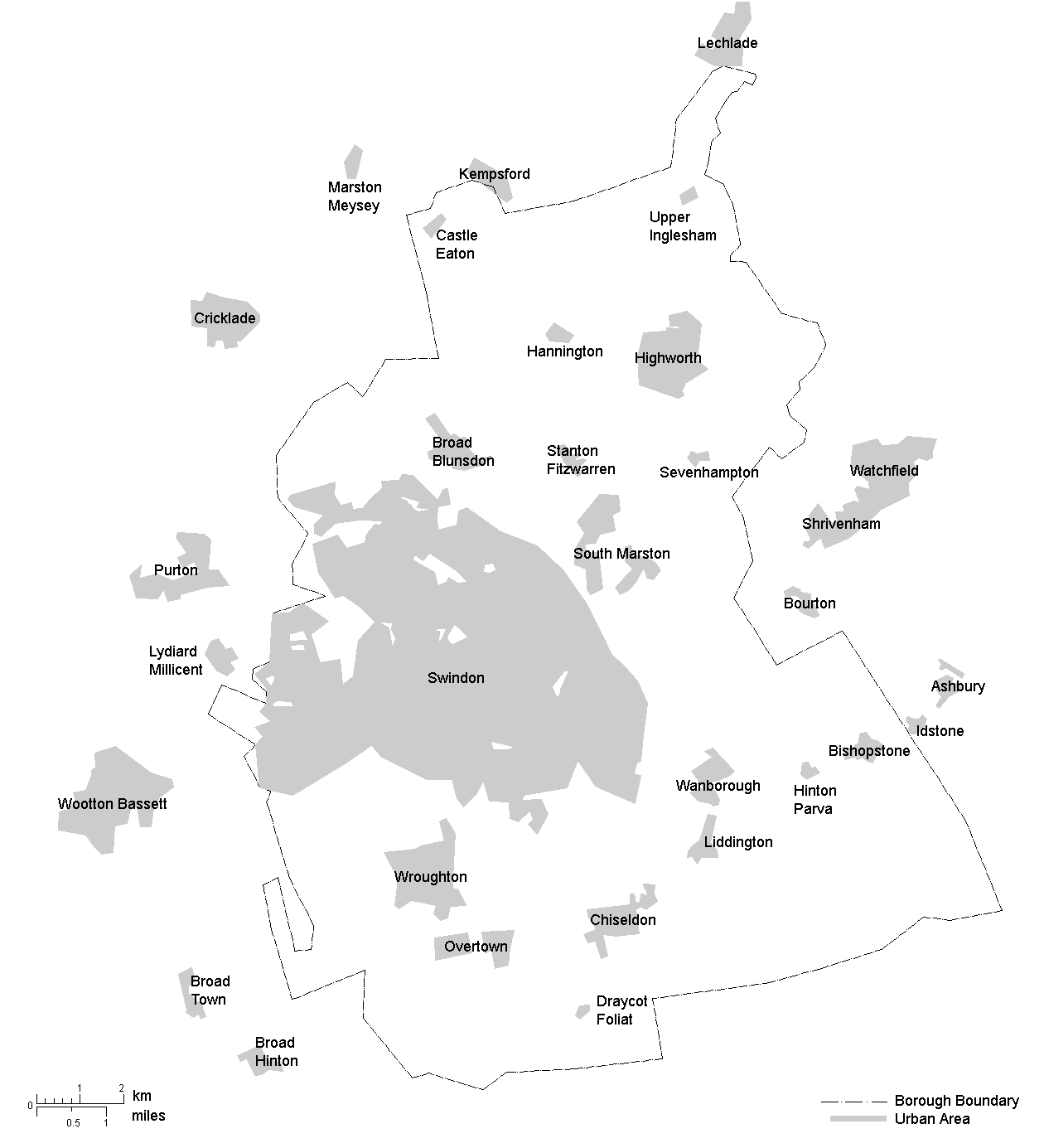
The borough of Swindon encompasses an area forming the north east corner of Wiltshire and is bordered by two other counties, Gloucestershire (to the north) and Oxfordshire (to the east). West Berkshire is also only a short distance from the borough's south-eastern frontier. The generally hilly landscape is sculpted by the upper Thames guiding the northern border, small tributaries draining into the Thames, and the Marlborough Downs rising toward the south.
The borough encompasses the Swindon urban area and surrounding countryside to the north, east and south, including the town of Highworth. It comprises the former Swindon Municipal Borough and a further 18 civil parishes:
- Bishopstone (with Hinton Parva)
- Blunsdon
- Castle Eaton
- Chiseldon
- Covingham
- Hannington
- Haydon Wick
- Highworth (town and surrounding district, including Sevenhampton)
- Inglesham
- Liddington
- Nythe, Eldene and Liden
- St Andrews
- South Marston
- Stanton Fitzwarren
- Stratton St Margaret
- Wanborough
- West Swindon
- Wroughton
Since 1 April 2017 the entire Borough has been parished, following the establishment of West Swindon parish and the creation of Central Swindon North and Central Swindon South (styled by its parish council as South Swindon). The two central parishes fall within the boundaries of the town and former municipal borough, divided along the Great Western Main Line railway.
At the same time:
- the part of Chiseldon parish north of the M4, including the former hamlet of Coate, was transferred to Central Swindon South;
- the parish of Blunsdon St Andrew was divided into St Andrews and Blunsdon, the A419 forming the boundary between them;
- the parish of Nythe was expanded to form Nythe, Eldene and Liden.
Demographics
Ethnicity
The population of the Borough of Swindon was historically ethnically homogeneous, White British, but is now becoming less homogeneous, with the largest ethnic group, White British, constituting 74.2% of the population in the 2021 census. This proportion has consistently declined in each modern census, down from 91.5% in the 2001 census.
In the 2021 census, the ethnic composition of the Borough of Swindon comprised: 81.5% White, 11.6% Asian, 2.6% Black, 2.8% Mixed, and 1.5% Other.
- White (81.5%): English, Welsh, Scottish, Northern Irish or British (74.2%), Irish (0.7%), Gypsy or Irish Traveller (0.1%), Roma (0.2%), and Other White (6.3%).
- Asian (11.6%): Indian (7.6%), Pakistani (0.9%), Bangladeshi (0.6%), Chinese (0.5%), and Other Asian (2.1%).
- Black (2.6%): African (1.8%), Caribbean (0.4%), and Other Black (0.4%).
- Mixed (2.8%): White and Asian (0.7%), White and Black African (0.5%), White and Black Caribbean (0.8%), and Other Mixed or Multiple ethnic groups (0.8%).
- Other (1.5%): Arab (0.1%) and Any other ethnic group (1.3%). Note: Sub-group totals may not sum exactly to the group total due to rounding.
| Ethnic Group | 2001 Census | 2011 Census | 2021 Census |
|---|---|---|---|
| White | 95.2% | 89.8% | 81.5% |
| Asian | 2.6% | 6.4% | 11.6% |
| Black | 0.7% | 1.4% | 2.6% |
| Mixed | 1.1% | 2.0% | 2.8% |
| Other | 0.4% | 0.4% | 1.5% |
Note: The 2001 census figures for 'Asian' and 'Other' have been adjusted to reflect the 2011 reclassification of the Chinese ethnic group from 'Other' to 'Asian' to allow comparison across census years.
Religion
In the 2021 census, the religious composition of the Borough of Swindon comprised: 46.6% Christian, 40.5% No religion, 2.7% Muslim, 2.5% Hindu, 0.7% Buddhist, 0.6% Sikh, 0.1% Jewish, 0.6% Other religion, and 5.6% Not stated.
| Religion | 2001 Census | 2011 Census | 2021 Census |
|---|---|---|---|
| Christian | 70.1% | 57.5% | 46.6% |
| No religion | 19.1% | 31.0% | 40.5% |
| Muslim | 1.0% | 1.7% | 2.7% |
| Hindu | 0.6% | 1.2% | 2.5% |
| Buddhist | 0.3% | 0.6% | 0.7% |
| Sikh | 0.6% | 0.6% | 0.6% |
| Jewish | 0.1% | 0.1% | 0.1% |
| Other religion | 0.4% | 0.5% | 0.6% |
| Not stated | 7.9% | 6.8% | 5.6% |
Governance
Main article: Swindon Borough Council
The council follows a leader and cabinet model and has 57 members elected by 20 wards. Elections are held in three out of every four years, with one-third of the seats being elected at each election. From the first election in 1996 to the 2000 election, Labour had a majority on the council. Following a period where no party had a majority, the Conservatives gained a majority at the 2003 election and had control until the 2023 election, when Labour took control.
Wards
- Blunsdon & Highworth (3)
- Central (3)
- Chiseldon & Lawn (2)
- Covingham & Dorcan (3)
- Eastcott (3)
- Gorse Hill & Pinehurst (3)
- Haydon Wick (3) †
- Liden, Eldene & Park South (3)
- Lydiard & Freshbrook (3)
- Mannington & Western (3)
- Old Town (3)
- Penhill & Upper Stratton (3)
- Priory Vale (3)
- Ridgeway (1)
- Rodbourne Cheney (3)
- Shaw (3)
- St Andrews (3)
- St Margaret & South Marston (3)
- Walcot & Park North (3)
- Wroughton & Wichelstowe (3)
Other elections
The borough is divided into three Parliamentary constituencies. Swindon North and Swindon South are wholly within the boundaries of the borough of Swindon, while East Wiltshire includes the Swindon borough council wards of Wroughton & Wichelstowe and Ridgeway, and the parish of Chiseldon. Swindon North and Swindon South are seen as key marginal seats at general elections, having been bellwether seats since 1997 when their predecessor constituencies were created; currently both seats are held by the Labour Party. East Wiltshire was won by the Conservative candidate Danny Kruger when it was first contested in 2024; in 2025 he switched allegiance to Reform UK.
In the 2016 United Kingdom European Union membership referendum, the Borough of Swindon electorate voted in favour of Brexit, with 54.7% supporting withdrawal from the European Union and 45.3% opting to remain a member.
References
References
- "Swindon Local Authority".
- "Swindon Municipal Borough". GB Historical GIS / University of Portsmouth.
- {{cite legislation UK. (1972)
- {{cite legislation UK. (1973)
- (28 March 1974). "District Councils and Boroughs". [[Hansard.
- {{cite legislation UK. (1995)
- "Historical information on changes to electoral arrangements of Local authorities, Parliamentary areas and European Parliamentary boundaries". Ordnance Survey.
- "Thamesdown Transport".
- {{cite legislation UK. (1997)
- (March 2017). "Community governance review - next steps". Swindon Borough Council.
- (19 January 2017). "The Swindon Borough (Reorganisation of Community Governance) No. 1 Order 2017".
- "South Swindon Parish Council".
- Seaward, Tom. (1 November 2017). "South Swindon Parish Council responds to name change block".
- "KS006 - Ethnic group". Office for National Statistics.
- "KS201EW - Ethnic group". Office for National Statistics.
- "TS021 - Ethnic group". Office for National Statistics.
- "KS007 - Religion". Office for National Statistics.
- "KS209EW - Religion". Office for National Statistics.
- "TS030 - Religion". Office for National Statistics.
- "Cabinet and administration".
- "How to become a councillor".
- "Election Maps: Great Britain". Ordnance Survey.
- (2025-09-15). "Conservative MP Danny Kruger defects to Reform UK".
- "EU Referendum: Local Results". British Broadcasting Corporation.
This article was imported from Wikipedia and is available under the Creative Commons Attribution-ShareAlike 4.0 License. Content has been adapted to SurfDoc format. Original contributors can be found on the article history page.
Ask Mako anything about Borough of Swindon — get instant answers, deeper analysis, and related topics.
Research with MakoFree with your Surf account
Create a free account to save articles, ask Mako questions, and organize your research.
Sign up freeThis content may have been generated or modified by AI. CloudSurf Software LLC is not responsible for the accuracy, completeness, or reliability of AI-generated content. Always verify important information from primary sources.
Report