From Surf Wiki (app.surf) — the open knowledge base
Boron, California

| Field | Value |
|---|---|
| official_name | Boron, California |
| settlement_type | unincorporated community |
| census-designated place | |
| image_map | Kern_County_California_Incorporated_and_Unincorporated_areas_Boron_Highlighted.svg |
| mapsize | 250x200px |
| map_caption | Location in Kern County and the state of California |
| pushpin_map | USA#California#USA California Southern |
| pushpin_map_caption | Location in the United States |
| subdivision_type | Country |
| subdivision_name | United States |
| subdivision_type1 | State |
| subdivision_name1 | California |
| subdivision_type2 | County |
| subdivision_name2 | Kern |
| leader_title | N/A |
| leader_title1 | State senator |
| leader_name1 | |
| leader_title2 | Assemblymember |
| leader_name2 | |
| leader_title3 | U. S. rep. |
| leader_name3 | |
| unit_pref | Imperial |
| area_footnotes | |
| area_total_sq_mi | 13.72 |
| area_land_sq_mi | 13.71 |
| area_water_sq_mi | 0.01 |
| area_total_km2 | 35.54 |
| area_land_km2 | 35.52 |
| area_water_km2 | 0.02 |
| area_water_percent | 0.15 |
| population_as_of | 2020 |
| population_total | 2086 |
| population_density_km2 | 58.73 |
| population_density_sq_mi | 152.12 |
| timezone | PST |
| utc_offset | -8 |
| coordinates | |
| elevation_footnotes | |
| elevation_ft | 2520 |
| timezone_DST | PDT |
| utc_offset_DST | -7 |
| postal_code_type | ZIP codes |
| postal_code | 93516, 93596 |
| area_code_type | Area codes |
| area_code | 442/760 |
| blank_name | FIPS code |
| blank_info | 06-07568 |
| blank1_name | GNIS feature ID |
| blank1_info | 2407886 |
census-designated place Boron (formerly Amargo, Baker, Borate, and Kern) is an unincorporated place in Kern County, California, United States. Boron is 15 mi southwest of Red Rock Mountain at an elevation of 2467 feet. For statistical purposes, the United States Census Bureau has defined Boron as a census-designated place (CDP). The population was 2,086 at the 2020 census, up from 2,025 at the 2000 census. Boron is named after the element boron and is the site of the world's largest source of the boron compound boric acid.
Boron is on the western edge of the Mojave Desert. Within a half day's drive one can view the highest and lowest points in the contiguous 48 states of the United States (Mount Whitney and Death Valley), the world's oldest tree, the bristlecone pine, and the cities of Los Angeles and Las Vegas.
Boron is home to the Rio Tinto Borax Mine, California's largest open-pit mine, which is also the largest borax mine in the world.
Geography
Boron is on the border of Kern and San Bernardino Counties along State Route 58. Boron is 65 mi north of Palmdale, 85 mi east of Bakersfield, and 40 mi west of Barstow in the Antelope Valley region of California's Mojave Desert. According to the United States Census Bureau, the CDP has a total area of 13.82 sqmi, over 99 percent of which is land.
Demographics
|align-fn=center 1860–1870 1880-1890 1900 1910 1920 1930 1940 1950 1960 1970 1980 1990 2000 2010 2020
Boron first appeared as an unincorporated place in the 1970 U.S. census; and as a census designated place in the 1980 United States census.
2020 census
| Race / Ethnicity (NH = Non-Hispanic) | title=P004: Hispanic or Latino, and Not Hispanic or Latino by Race – 2000: DEC Summary File 1 – Boron CDP, California | url=https://data.census.gov/table?g=160XX00US0607568&tid=DECENNIALSF12000.P004 | website=United States Census Bureau | access-date= }} | title=P2: Hispanic or Latino, and Not Hispanic or Latino by Race – 2010: DEC Redistricting Data (PL 94-171) – Boron CDP, California | url=https://data.census.gov/cedsci/table?q=p2&g=160XX00US0607568&tid=DECENNIALPL2010.P2 | website=United States Census Bureau | access-date= }} | Pop 2020 | % 2000 | % 2010 | % 2020 |
|---|---|---|---|---|---|---|---|---|---|---|---|---|
| White alone (NH) | 1,644 | 1,532 | 1,145 | 81.19% | 68.00% | 54.89% | ||||||
| Black or African American alone (NH) | 45 | 158 | 167 | 2.22% | 7.01% | 8.01% | ||||||
| Native American or Alaska Native alone (NH) | 47 | 40 | 28 | 2.32% | 1.78% | 1.34% | ||||||
| Asian alone (NH) | 32 | 44 | 44 | 1.58% | 1.95% | 2.11% | ||||||
| Native Hawaiian or Pacific Islander alone (NH) | 2 | 4 | 5 | 0.10% | 0.18% | 0.24% | ||||||
| Other race alone (NH) | 10 | 1 | 11 | 0.49% | 0.04% | 0.53% | ||||||
| Mixed race or Multiracial (NH) | 62 | 68 | 144 | 3.06% | 3.02% | 6.90% | ||||||
| Hispanic or Latino (any race) | 183 | 406 | 542 | 9.04% | 18.02% | 25.98% | ||||||
| Total | 2,025 | 2,253 | 2,086 | 100.00% | 100.00% | 100.00% |
The 2020 United States census reported that Boron had a population of 2,086. The population density was 152.1 PD/sqmi. The racial makeup of Boron was 62.0% White, 8.5% African American, 2.3% Native American, 2.3% Asian, 0.4% Pacific Islander, 9.8% from other races, and 14.7% from two or more races. Hispanic or Latino of any race were 26.0% of the population.


The whole population lived in households. There were 831 households, out of which 28.5% included children under the age of 18, 37.4% were married-couple households, 6.7% were cohabiting couple households, 29.7% had a female householder with no partner present, and 26.1% had a male householder with no partner present. 31.8% of households were one person, and 13.7% were one person aged 65 or older. The average household size was 2.51.
The age distribution was 26.1% under the age of 18, 7.7% aged 18 to 24, 22.0% aged 25 to 44, 27.7% aged 45 to 64, and 16.5% who were 65years of age or older. The median age was 39.3years. For every 100 females, there were 104.9 males.
There were 1,051 housing units at an average density of 76.6 /mi2, of which 831 (79.1%) were occupied. Of these, 52.7% were owner-occupied, and 47.3% were occupied by renters.
In 2023, the US Census Bureau estimated that the median household income was $61,607, and the per capita income was $27,933. About 25.0% of families and 31.3% of the population were below the poverty line.
History
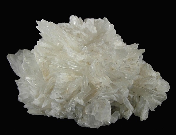
Borate evaporites in the form of colemanite was first reported in 1913 during drilling of a water well. Claims were acquired by the Pacific Coast Borax Company and exploration continued. In 1925 commercial colemanite production began. In the 1920s and 30s borates were produced from the Baker and West Baker mines.
The first post office at Boron opened in 1938.
Industry
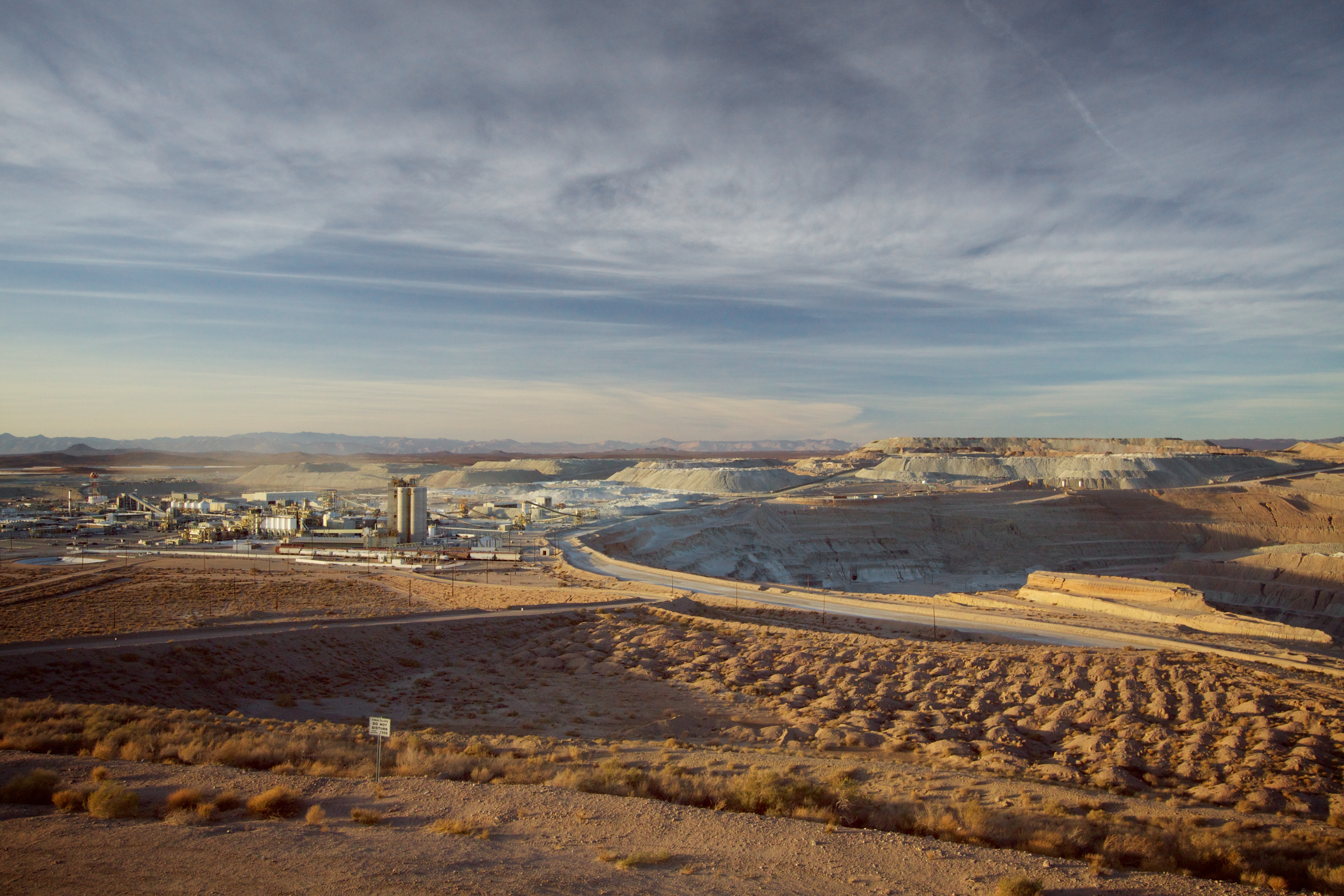

A large borax deposit was discovered in 1925, and the mining town of Boron was established soon thereafter. This borax deposit is the world's largest borax mine. It is owned by Rio Tinto Minerals (formerly U.S. Borax). It is operated as an open-pit mine, the largest open-pit mine in California. This mine supplies nearly half of the world's supply of refined borates. Rio Tinto Minerals is Boron's primary employer, employing over 800 people.
Workers at Rio Tinto are represented by Local 30 Mine, Mineral and Processing Workers of the International Longshore and Warehouse Union. Originally represented by Local 85 of the International Chemical Workers' Union, workers voted to affiliate with the ILWU in 1966. During a 2010 labor dispute, workers were locked out by Rio Tinto for 107 days until support from the community and organized labor across California and elsewhere allowed both parties to successfully negotiate a new collective bargaining agreement. The dispute was covered in a 2010 documentary entitled Locked Out.
6 mile east of Boron, across the county line in San Bernardino County, is what was, until 2014, the world's largest solar power production facility. The Kramer Junction Company (KJC) is the managing general partner of the five 30 megawatt Solar Energy Generating Systems (SEGS) facilities in the Mojave Desert at Kramer Junction, California. Together with its wholly owned subsidiary, KJC Operating Company, KJC operates and manages these facilities (SEGS III-VII).
Attractions

- Saxon Aerospace Museum, honors aviation history related to nearby Edwards Air Force Base and its Air Force Test Center, the Air Force Research Laboratory and NASA Dryden
- Borax Visitor Center at Rio Tinto Borax Mine, provides information about borax, how it is mined, and how it is used
- Twenty Mule Team Museum, adjacent to the Saxon Aerospace Museum, explains the Twenty-mule teams that originally hauled borax
- Boron Chamber Weather Station, a satirical weather forecast and cultural landmark of the town
Public services
Law enforcement
Law enforcement services are provided by the Kern County Sheriff's Department. From 1933 to 1954, personnel from the Mojave substation met the law enforcement need of the Boron area. The first actual office space occupied by the sheriff's office in Boron was a quonset hut shared with the fire department in the 12200 block of Boron Avenue. This continued until 1963 when the sheriff's office established the substation building at 26949 Cote Street. This building housed a small jail and the court in Boron, which operated one day a week.
A federal prison was closed in 2000.
Fire services
In 1969 the new Boron station 17 opened at 26965 Cote Street. This fire station is operated by the Kern County Fire Department.
Schools
Boron schools are part of the Muroc Joint Unified School District. The local Boron schools include the K – 6 grade West Boron Elementary School, and the 7 – 12th grade Boron High School. Boron High School's mascot is the Bobcat. Boron's first school, Gephart School was built in 1929. It burned to the ground in 1994.
Churches
Boron's original church building was completed for the First Baptist Church in 1940. Boron currently has eight churches. They are the Assembly of God Church, the Boron Bible Church, the Church of Christ, the Church of Jesus Christ of Latter-day Saints, the First Baptist Church of Boron, the Jesus Name Tabernacle United Pentecostal Church, St. Joseph's Catholic Church and Christians in Faith Church.
Notable residents
- Boron was the home of "Walking George" Swain, whose penchant for walking made him a legend. George earned his name as "Walking George" because he never owned a car, or house, and walked to and from work—from his home, which was always rumored to be just a hole in the desert. He supposedly kept himself warm at night with a covering of newspapers. His wardrobe was always the same: wrinkled shirt and pants with well-worn boots. Swain was a chemist at the borax plant in Boron. He attended local events and often played the piano for entertainment. He taught piano to children in Boron and played at the Baptist Church. On his 59th birthday in 1978 an article about George appeared in the Los Angeles Times. By May 1979 he was featured on the TV show Real People. He died on April 25, 2000.
- Boron was home to Pancho Barnes from 1966 to 1975. Barnes was a world-renowned air race and stunt pilot during the 1920s and 1930s. She is better known, however, for being the matron of the Happy Bottom Riding Club. She was forced to move when, during a heated dispute with Edwards Air Force Base over the expansion of one of the nearby base's runways, the club mysteriously burned down. Years later Barnes moved to Boron from Gypsy Springs when her age no longer allowed her to properly tend to her ranch. She died in Boron during the spring of 1975.
Media
The movie Erin Brockovich (2000), starring Julia Roberts, and various other movies have been filmed in the town, often using local residents as extras.
- Movies/shows using locations in and around Boron
- Locked Out (2010)
- Erin Brockovich (2000)
- Gentleman Don La Mancha (2004)
- Gridiron Gang (1993) (TV)
- Neon Signs (1996)
- Spotlight on Location: Erin Brockovich (2000) (TV)
- ...aka Making of 'Erin Brockovich', The (2000) (TV)
- Death Valley Days (1952–1975)
- The Carpetbaggers (1964)
References
References
- "Final Maps {{!}} California Citizens Redistricting Commission".
- {{Cite GovTrack. CA. 23
- "2020 U.S. Gazetteer Files". United States Census Bureau.
- {{GNIS. 2407886
- "Decennial Census by Decade".
- "1870 Census of Population - Population of Civil Divisions less than Counties - California - Almeda County to Sutter County".
- "1870 Census of Population - Population of Civil Divisions less than Counties - California - Tehama County to Yuba County".
- "1890 Census of Population - Population of California by Minor Civil Divisions".
- "1900 Census of Population - Population of California by Counties and Minor Civil Divisions".
- "1910 Census of Population - Supplement for California".
- "1920 Census of Population - Number of Inhabitants - California".
- "1930 Census of Population - Number and Distribution of Inhabitants - California".
- "1940 Census of Population - Number of Inhabitants - California".
- "1950 Census of Population - Number of Inhabitants - California".
- "1960 Census of Population - Number of Inhabitants - California".
- "1960 Census of Population - General population Characteristics - California".
- "1970 Census of Population - Number of Inhabitants - California".
- "1980 Census of Population - Number of Inhabitants - California".
- "1990 Census of Population - Population and Housing Unit Counts - California".
- "2000 Census of Population - Population and Housing Unit Counts - California".
- "2010 Census of Population - Population and Housing Unit Counts - California".
- "P004: Hispanic or Latino, and Not Hispanic or Latino by Race – 2000: DEC Summary File 1 – Boron CDP, California".
- "P2: Hispanic or Latino, and Not Hispanic or Latino by Race – 2010: DEC Redistricting Data (PL 94-171) – Boron CDP, California".
- "P2: Hispanic or Latino, and Not Hispanic or Latino by Race – 2020: DEC Redistricting Data (PL 94-171) – Boron CDP, California".
- "Boron CDP, California; DP1: Profile of General Population and Housing Characteristics - 2020 Census of Population and Housing".
- "Boron CDP, California; P16: Household Type - 2020 Census of Population and Housing".
- "Boron CDP, California; DP03: Selected Economic Characteristics - 2023 ACS 5-Year Estimates Comparison Profiles".
- [http://vredenburgh.org/desert_fever/pages/kern_county_07.htm Desert Fever, Kern County]
- {{California's Geographic Names. 1005
- [http://www.borax.com/borax5.html Rio Tinto Borax: About Borax: History] {{webarchive. link. (March 17, 2006)
- [http://ftp.dir.ca.gov/75thAnniversary/dir/story7/storyframe.html ftp.dir.ca.gov] {{dead link. (November 2016)
- [https://s3-us-west-2.amazonaws.com/prd-wret/assets/palladium/production/mineral-pubs/boron/boronmyb04.pdf minerals.usgs.gov]
- [https://leica-geosystems.com/SFTP/files/archived-files/Dez2004_mining_engineering_GPS.pdf leica-geosystems.com]
- [https://web.archive.org/web/20060115032334/http://ludb.clui.org/ex/i/CA4982/ U.S. Borax Boron Mine]
- "The ILWU Story". [[International Longshore and Warehouse Union]].
- (February 23, 1911). "Local 30 members mark lockout anniversary in Boron". [[International Longshore and Warehouse Union]].
- Slaughter, Jane. (May 18, 2010). "Settlement Voted Up in Boron, Calif., Lockout".
- (November 20, 2010). "Locked Out 2010: Premiere of new documentary film is shown first to families in Boron". [[International Longshore and Warehouse Union]].
- [http://www.nrel.gov/docs/legosti/fy98/22589.pdf Solar Trough Systems]
- [http://www.solel.com/products/pgeneration/ls2/kramerjunction/ Solel - Leading the World in Solar Thermal Energy. Kramer Junction SEGS III, IV, V, VI, VII]
- [http://www.co.kern.ca.us/sheriff/ Sheriff Home]
- [https://kernsheriff.org/Mojave Mojave Substation]
- [https://www.thedesertway.com/boron-fpc-ca/ Boron Federal Prison: Abandoned Club Fed]
- [http://www.kerncountyfire.org/ Kern County Fire Department Website]
- "Home".
- "muroc.k12.ca.us".
- "The Boron Sun: The Mystery of Gephart Middle School". Blogspot.
- "CAKERN-L Obit: Swain, George "Walking George" Wood". archiver.rootsweb.com.
- ''Mojave Desert News'', California City, Kern County, California
- Lauren Kessler, ''The Happy Bottom Riding Club - The Life and Times of Pancho Barnes,'' Random House, 2000, {{ISBN. 978-0812992526
- (March 31, 1975). "Florence Barnes, 20's Aviator, Dies". [[The New York Times]].
- (May 1, 2000). "Getting Angry Over Erin".
- [https://www.imdb.com/List?endings=on&&locations=Boron,%20California,%20USA&&heading=18;with+locations+including;Boron,%20California,%20USA Titles with locations including
Boron, California, USA] - [https://www.imdb.com/title/tt0406801/ The Gentleman Don La Mancha (2004)]
- [https://www.imdb.com/title/tt0117163/ Neon Signs (1996)]
- [https://www.imdb.com/title/tt0382314/ Spotlight on Location: Erin Brockovich (2000) (TV)]
- [http://www.visitkern.com/movies.asp Discover Kern County: Movies] {{webarchive. link. (April 17, 2008)
This article was imported from Wikipedia and is available under the Creative Commons Attribution-ShareAlike 4.0 License. Content has been adapted to SurfDoc format. Original contributors can be found on the article history page.
Ask Mako anything about Boron, California — get instant answers, deeper analysis, and related topics.
Research with MakoFree with your Surf account
Create a free account to save articles, ask Mako questions, and organize your research.
Sign up freeThis content may have been generated or modified by AI. CloudSurf Software LLC is not responsible for the accuracy, completeness, or reliability of AI-generated content. Always verify important information from primary sources.
Report