From Surf Wiki (app.surf) — the open knowledge base
Bogotá savanna
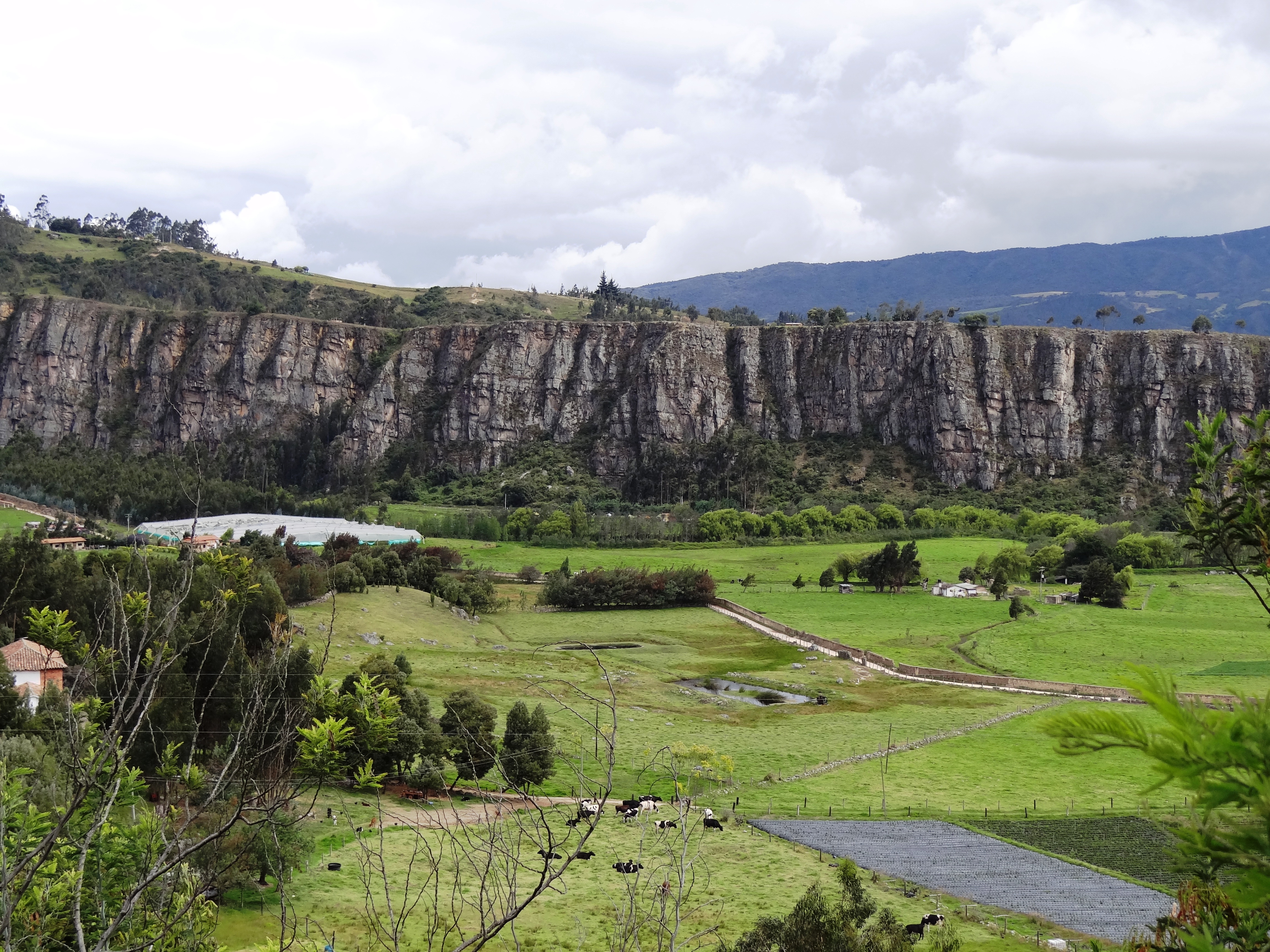
Motane savanna in Altiplano Cundiboyacense

Motane savanna in Altiplano Cundiboyacense
| Field | Value |
|---|---|
| name | Bogotá savanna |
| other_name | Sabana de Bogotá |
| photo | Bogota surroundings.jpg |
| photo_caption | The Bogotá savanna near the city of Bogotá |
| map_image | Sabana de Bogota.png |
| map_caption | Topography and outline of the Bogotá savanna |
| country | Colombia |
| state | Cundinamarca |
| region | Andean region |
| city | Bogotá |
| coordinates | |
| area_km2 | 4251.6 |
| type | Montane savanna |
| border | East: Eastern Hills |
| South: Sumapaz mountains | |
| North: Hills of Tausa and Suesca | |
| West: Western hills | |
| river | Bogotá, Teusacá, Torca, Juan Amarillo, Fucha, Tunjuelo |
| footnotes |
South: Sumapaz mountains North: Hills of Tausa and Suesca West: Western hills
The Bogotá savanna is a montane savanna, located in the southwestern part of the Altiplano Cundiboyacense in the center of Colombia. The Bogotá savanna has an extent of 4251.6 km2 and an average altitude of 2650 m. The savanna is situated in the Eastern Ranges of the Colombian Andes.
The Bogotá savanna is crossed from northeast to southwest by the 375 km long Bogotá River, which at the southwestern edge of the plateau forms the Tequendama Falls (Salto del Tequendama). Other rivers, such as the Subachoque, Bojacá, Fucha, Soacha and Tunjuelo Rivers, tributaries of the Bogotá River, form smaller valleys with very fertile soils dedicated to agriculture and cattle-breeding.
Before the Spanish conquest of the Bogotá savanna, the area was inhabited by the indigenous Muisca, who formed a loose confederation of various caciques, named the Muisca Confederation. The Bogotá savanna, known as Muyquytá, was ruled by the zipa. The people specialised in agriculture, the mining of emeralds, trade and especially the extraction of rock salt from rocks in Zipaquirá, Nemocón, Tausa and other areas on the Bogotá savanna. The salt extraction, a task exclusively of the Muisca women, gave the Muisca the name "The Salt People".
In April 1536, a group of around 800 conquistadors left the relative safety of the Caribbean coastal city of Santa Marta to start a strenuous expedition up the Magdalena River, the main fluvial artery of Colombia. Word got around among the Spanish colonisers that deep in the unknown Andes, a rich area with an advanced civilisation must exist. These tales bore the -not so much- legend of El Dorado; the city or man of gold. The Muisca, skilled goldworkers, held a ritual in Lake Guatavita where the new zipa would cover himself in gold dust and jump from a raft into the cold waters of the 3000 m high lake to the northeast of the Bogotá savanna.
After a journey of almost a year, where the Spanish lost over 80% of their soldiers, the conquistadors following the Suárez River, reached the Bogotá savanna in March 1537. The zipa who ruled the Bogotá savanna at the arrival of the Spanish was Tisquesusa. The Muisca posed little resistance to the Spanish strangers and Tisquesusa was defeated in April 1537 in Funza, in the centre of the savanna. He fled towards the western hills and died of his wounds in Facatativá, on the southwestern edge of the Bogotá savanna. The Spanish conquistador Gonzalo Jiménez de Quesada established the New Kingdom of Granada with capital Santa Fe de Bogotá on August 6, 1538. This started a process of colonisation, evangelisation and submittance of the Muisca to the new rule. Between 65 and 80% of the indigenous people perished due to European diseases as smallpox and typhus. The Spanish introduced new crops, replacing many of the New World crops that the Muisca cultivated.
Over the course of the 16th to early 20th century, the Bogotá savanna was sparsely populated and industrialised. The rise in population during the twentieth century and the expansion of agriculture and urbanisation reduced the biodiversity and natural habitat of the Bogotá savanna severely. Today, the Metropolitan Area of Bogotá on the Bogotá savanna hosts more than ten million people. Bogotá is the biggest city worldwide at altitudes above 2500 m. The many rivers on the savanna are highly contaminated and efforts to solve the environmental problems are conducted in the 21st century.
Etymology
Bogotá savanna is named after Bogotá, which is derived from Muysccubun Bacatá, which means "(Enclosure) outside of the farm fields".
Geography

Main article: Altiplano Cundiboyacense
The Bogotá savanna is the southwestern part of the larger Andean plateau, the Altiplano Cundiboyacense. The savanna is a montane savanna, bordered to the east by the Eastern Hills, the Sumapaz mountains in the south, the hills of Tausa and Suesca in the north and western hills of Cundinamarca in the west. The total surface area is 4251.6 km2.
Climate
The average temperature of the plateau is 14 C, but this can fluctuate between 0 and. The dry and rainy seasons alternate frequently during the year. The driest months are December, January, February and March. During the rainy months, the temperature tends to be more stable with variations between 9 and. June, July and August are the months that present the largest variations of temperature, and during the morning frost in the higher terrains surrounding the savanna is possible. Sometimes also ground frost is present, which has a negative impact on agriculture. Hail is a relatively common phenomenon on the savanna.
Hydrology


Rivers
- Bogotá River - 375 km
- Bojacá River
- Fucha River
- Teusacá River
- Juan Amarillo River
- Tunjuelo River
- Soacha River
- Neusa River
- Río Frío
- Subachoque River
Lakes
Natural
- Lake Guatavita - overlooking the northeastern part of the savanna
- Lake Herrera
Artificial
- Tominé Reservoir - northeast, biggest waterbody on the Bogotá savanna - 690 Mm3
- Neusa Reservoir - north - 102 Mm3
- El Muña Reservoir - south - 42 Mm3
- Lake Herrera (since 1973)
Waterfalls
- Tequendama Falls - southwestern limit
Wetlands
Main article: Wetlands of Bogotá
There is a system of wetlands (humedales) that regulate the soil moisture acting like sponges for the rain waters. Fifteen wetlands have a protected status, with various wetlands as unprotected. In 1950, the total surface area of the wetlands amounted to 150000 ha, but due to the urbanisation of the Colombian capital the total area has been reduced to 1500 ha.
| Map | |
|---|---|
| {{Location map+ | Colombia Bogotá |
| Wetland | Location | Altitude (m) | Area (ha) | Notes | Image | ||
|---|---|---|---|---|---|---|---|
| Guaymaral y Torca | Usaquén | ||||||
| Suba | 2547 | 73 | [[File:Yellow Hooded Blackbird 004.jpg | center | 100px]] | ||
| La Conejera | Suba | 2544 | 58.9 | [[File:Humedal de la conejera.jpg | center | 100px]] | |
| Córdoba | Suba | 2548 | 40.51 | [[File:Árboles en Bogotá - Humedal de Córdoba Vegetación.JPG | center | 100px]] | |
| Tibabuyes | |||||||
| Juan Amarillo | Suba | ||||||
| Engativá | 2539 | 222.58 | [[File:Humedal tibabuyes.jpg | center | 100px]] | ||
| Jaboque | Engativá | 2539 | 148 | [[File:Humedal Jaboque Engativá Bogotá.JPG | center | 100px]] | |
| Santa María del Lago | Engativá | 2549 | 12 | [[File:Humedal SantaMaria.jpg | center | 50px]] | |
| El Burro | Kennedy | 2541 | 18.84 | [[File:Humedal Burro.jpg | center | 100px]] | |
| La Vaca | Kennedy | 2548 | 7.96 | ||||
| Techo | Techo, Kennedy | 2545 | 11.46 | ||||
| Capellanía | Fontibón | 2542 | 27.05 | [[File:Capella pan part.jpg | center | 100px]] | |
| Meandro del Say | Fontibón | ||||||
| Mosquera | 2548 | 13.6 | |||||
| Tibanica | Bosa | ||||||
| Soacha | 2542 | 28.8 | |||||
| El Salitre | Barrios Unidos | 2558 | 6.4 | ||||
| La Isla | Bosa | 2550 | 7.7 | ||||
| La Florida | Funza | 2542 | 26 | [[File:Ave Parque la Florida.jpg | center | 100px]] |
Biodiversity
Despite the continuous urbanisation and industrial activities, the Bogotá savanna is a rich biodiverse area with many bird species registered. The diversity of mammals, amphibians and reptiles is much lower. Before the arrival of the European colonisers, the savanna was populated predominantly by white-tailed deer, the main ingredient of the Muisca cuisine. Today, this species of deer, as well as the once common spectacled bear, is restricted to protected areas surrounding the Bogotá savanna. The Thomas van der Hammen Natural Reserve is a protected area in the north of Bogotá.
History
Ab - El Abra Ti - Tibitó Te - Tequendama P - Piedras del Tunjo Ag - Aguazuque C - Checua H - Lake Herrera The earliest confirmed inhabitation of present-day Colombia was on the Bogotá savanna with sites El Abra, Tequendama and Tibitó, where semi-nomadic hunter-gatherers lived in caves and rock shelters. One of the first evidences of settlement in open area space was Aguazuque, whose oldest dated remains are analysed to be 5000 years old. This prehistorical preceramic period was followed by the Herrera Period, commonly defined from 800 BCE to 800 AD.
Muisca Confederation
Main article: Muisca Confederation
At the arrival of the Spanish conquistadors, the region was inhabited by the Muisca who lived in hundreds of small villages scattered across the plateau. These villages were individually ruled by caciques who at the same time paid tribute to the zipa, ruler of Bacatá. The Muisca were known as "The Salt People", thanks to their extraction of rock salt from brines in large pots heated over fires. This process was the exclusive task of the Muisca women.
The economy of the Muisca, meaning "person" or "people" in their indigenous version of Chibcha; Muysccubun, was self-sufficient due to the advanced agriculture on the fertile soils of the frequently flooding Bogotá savanna. More tropical and subtropical agricultural products as avocadoes and cotton were traded with their neighbours, in particular the Guane and Lache in the north and northeast and the Guayupe, Achagua and Tegua in the east.
The Muisca were known as skilled goldworkers, represented in the famous Muisca raft, that symbolises the initiation ritual of the new zipa in Lake Guatavita. This ritual, where the zipa covered himself in gold dust and jumped in the 3000 m altitude lake, gave rise to the -not so much- legend of El Dorado.
Spanish conquest


Main article: Spanish conquest of the Muisca
In April 1536, a group of around 800 conquistadors left the relative safety of the Caribbean coastal city of Santa Marta to start a strenuous expedition up the Magdalena River, the main fluvial artery of Colombia. Word got around among the Spanish colonisers that deep in the unknown Andes, a rich area with an advanced civilisation must exist. These tales bore the -not so much- legend of El Dorado; the city or man of gold. The Muisca, skilled goldworkers, held a ritual in Lake Guatavita where the new zipa would cover himself in gold dust and jump from a raft into the cold waters of the 3000 m high lake to the northeast of the Bogotá savanna.
After a journey of almost a year, where the Spanish lost over 80% of their soldiers, the conquistadors following the Suárez River, reached the Bogotá savanna in March 1537. The zipa who ruled the Bogotá savanna at the arrival of the Spanish was Tisquesusa. The Muisca posed little resistance to the Spanish strangers and Tisquesusa was defeated in April 1537 in Funza, in the centre of the savanna. He fled towards the western hills and died of his wounds in Facatativá, on the southwestern edge of the Bogotá savanna. The Spanish conquistador Gonzalo Jiménez de Quesada established the New Kingdom of Granada with capital Santa Fe de Bogotá on August 6, 1538. This started a process of colonisation, evangelisation and submittance of the Muisca to the new rule. Between 65 and 80% of the indigenous people perished due to European diseases as smallpox and typhus. The Spanish introduced new crops, replacing many of the New World crops that the Muisca cultivated.
The Spanish colonizers engaged in the construction of Spanish-style towns to replace all the indigenous villages and in the process of assimilation and religious convert of the Muisca. The majority of those villages kept their indigenous names, but some were slightly modified in time, like Suacha which became Soacha, Hyntiba becoming Fontibón and Bacatá becoming Bogotá.
Modern history
Over the course of the 16th to early 20th century, the Bogotá savanna was sparsely populated and industrialised. The rise in population during the twentieth century and the expansion of agriculture and urbanisation reduced the biodiversity and natural habitat of the Bogotá savanna severely. Today, the Metropolitan Area of Bogotá on the Bogotá savanna hosts more than ten million people. Bogotá is the biggest city worldwide at altitudes above 2500 m. The many rivers on the savanna are highly contaminated and efforts to solve the environmental problems are conducted in the 21st century.
Timeline of inhabitation
Cities

The main cities of the Bogotá savanna, in addition to the capital city of Bogotá, are: Mosquera, Soacha, Madrid, Funza, Facatativá, Subachoque, El Rosal, Tabio, Tenjo, Cota, Chía, Cajicá, Zipaquirá, Nemocón, Sopó, Tocancipá, Gachancipá, Sesquilé, Suesca, Chocontá and Guatavita.
List of municipalities
| Municipality | |||||||
|---|---|---|---|---|---|---|---|
| Locality | Altitude | ||||||
| urban centre (m) | Surface area | ||||||
| (km2) | Inhabitants | Remarks | Map | ||||
| Bogotá | 2640 | 1587 | 7,980,001** | Named after Bacatá | |||
| Capital of Colombia | |||||||
| Biggest city at altitudes | |||||||
| above 2500 m | [[File:Colombia Bogotá location map.png | 100px | center]] | ||||
| Usaquén | 2650 | 65.31 | 449,621** | [[File:Bogotá - Usaquén.svg | 100px | center]] | |
| Chapinero | 2640 | 38.15 | 122,507** | [[File:Bogotá - Chapinero.svg | 100px | center]] | |
| Santa Fe | 2640 | 45.17 | 96,241** | [[File:Bogotá - Santa Fe.svg | 100px | center]] | |
| San Cristóbal | 2640 | 49.09 | 404,350** | [[File:Bogotá - San Cristóbal.svg | 100px | center]] | |
| Usme | 2700 | 119.04 | 314,431** | [[File:Bogotá - Usme.svg | 100px | center]] | |
| Tunjuelito | 2600 | 9.91 | 182,532** | [[File:Bogotá - Tunjuelito.svg | 100px | center]] | |
| Bosa | 2600 | 23.93 | 637,283** | [[File:Bogotá - Bosa.svg | 100px | center]] | |
| Kennedy | 2700 | 38.59 | 979,914** | [[File:Bogotá - Kennedy.svg | 100px | center]] | |
| Fontibón | 2600 | 33.28 | 317,179** | [[File:Bogotá - Fontibón.svg | 100px | center]] | |
| Engativá | 2600 | 35.88 | 824,337** | [[File:Bogotá - Engativá.svg | 100px | center]] | |
| Suba | 2700 | 100.56 | 1,161,500** | [[File:Bogotá - Suba.svg | 100px | center]] | |
| Barrios Unidos | 2600 | 11.9 | 230,066** | [[File:Bogotá - Barrios Unidos.svg | 100px | center]] | |
| Teusaquillo | 2600 | 14.19 | 139,298** | [[File:Bogotá - Teusaquillo.svg | 100px | center]] | |
| Los Mártires | 2600 | 6.51 | 94,944** | [[File:Bogotá - Los Mártires.svg | 100px | center]] | |
| Antonio Nariño | 2600 | 4.88 | 119,565** | [[File:Bogotá - Antonio Nariño.svg | 100px | center]] | |
| Puente Aranda | 2600 | 17.31 | 250,715** | [[File:Bogotá - Puente Aranda.svg | 100px | center]] | |
| La Candelaria | 2640 | 2.06 | 22,115** | [[File:Bogotá - La Candelaria.svg | 100px | center]] | |
| Rafael Uribe Uribe | 2600 | 13.83 | 378.780** | [[File:Bogotá - Rafael Uribe Uribe.svg | 100px | center]] | |
| Ciudad Bolívar | 2700 | 130 | 593,937** | [[File:Bogotá - Ciudad Bolívar.svg | 100px | center]] | |
| Soacha | 2565 | 184.45 | 522,442** | Preceramic site Tequendama | |||
| Herrera site | |||||||
| Muisca ceramics production | |||||||
| Petrographs found | [[File:Colombia - Cundinamarca - Soacha.svg | 100px | center]] | ||||
| Sibaté | 2700 | 125.6 | 38,412** | Petrographs found | |||
| El Muña Reservoir | [[File:Colombia - Cundinamarca - Sibaté.svg | 100px | center]] | ||||
| Mosquera | 2516 | 107 | 82,750** | Lake Herrera | |||
| Petrographs found | [[File:Colombia - Cundinamarca - Mosquera.svg | 100px | center]] | ||||
| Bojacá | 2598 | 109 | 11,254** | Lake Herrera | |||
| Petrographs found | [[File:Colombia - Cundinamarca - Bojacá.svg | 100px | center]] | ||||
| Chía | 2564 | 80 | 129,652** | Moon Temple | |||
| Herrera site | |||||||
| Petrographs found | [[File:Colombia - Cundinamarca - Chía.svg | 100px | center]] | ||||
| Cota | 2566 | 55 | 24,916** | Petrographs found | |||
| Muisca community | [[File:Colombia - Cundinamarca - Cota.svg | 100px | center]] | ||||
| Cajicá | 2558 | 50.4 | 56,875** | Located in the funnel of the northern savanna | [[File:Colombia - Cundinamarca - Cajicá.svg | 100px | center]] |
| Facatativá | 2586 | 158 | 134,522** | Piedras del Tunjo | [[File:Colombia - Cundinamarca - Facatativá.svg | 100px | center]] |
| Funza | 2548 | 70 | 75,350** | Muisca market town | [[File:Colombia - Cundinamarca - Funza.svg | 100px | center]] |
| Madrid | 2554 | 120.5 | 77,627** | Lake Herrera | |||
| Petrographs found | [[File:Colombia - Cundinamarca - Madrid.svg | 100px | center]] | ||||
| El Rosal | 2685 | 86.48 | 17,254** | [[File:Colombia - Cundinamarca - El Rosal.svg | 100px | center]] | |
| Zipacón | 2550 | 70 | 5570** | Agriculture | |||
| Place of meditation for the zipa | |||||||
| Petrographs found | [[File:Colombia - Cundinamarca - Zipacón.svg | 100px | center]] | ||||
| Subachoque | 2663 | 211.53 | 16,117** | Petrographs found | [[File:Colombia - Cundinamarca - Subachoque.svg | 100px | center]] |
| Tabio | 2569 | 74.5 | 27,033** | Hot springs used by the Muisca | [[File:Colombia - Cundinamarca - Tabio.svg | 100px | center]] |
| Tenjo | 2587 | 108 | 18,387** | Petrographs found | [[File:Colombia - Cundinamarca - Tenjo.svg | 100px | center]] |
| Zipaquirá | 2650 | 197 | 124,376** | El Abra | |||
| Muisca salt mines | |||||||
| Important market town | |||||||
| Petrographs and petroglyphs found | [[File:Colombia - Cundinamarca - Zipaquirá.svg | 100px | center]] | ||||
| Nemocón | 2585 | 98.1 | 13,488** | Muisca salt mines | |||
| Preceramic site Checua | |||||||
| Petrographs found | [[File:Colombia - Cundinamarca - Nemocón.svg | 100px | center]] | ||||
| Cogua | 2600 | 113 | 22,361** | Muisca ceramics production | |||
| Petrographs found | |||||||
| Neusa Reservoir | [[File:Colombia - Cundinamarca - Cogua.svg | 100px | center]] | ||||
| Tocancipá | 2605 | 73.51 | 31,975** | Preceramic site Tibitó | |||
| Muisca ceramics production | |||||||
| Important market town | |||||||
| Petrographs found | [[File:Colombia - Cundinamarca - Tocancipá.svg | 100px | center]] | ||||
| Gachancipá | 2568 | 44 | 14,442** | Muisca mummy found | |||
| Muisca ceramics production | [[File:Colombia - Cundinamarca - Gachancipá.svg | 100px | center]] | ||||
| Guasca | 2710 | 346 | 14,759** | Siecha Lakes | |||
| Muisca ceramics production | |||||||
| Petrographs found | [[File:Colombia - Cundinamarca - Guasca.svg | 100px | center]] | ||||
| Guatavita | 2680 | 247.3 | 6898** | Muisca ceramics production | |||
| Main goldworking town | |||||||
| Petrographs found | |||||||
| Tominé Reservoir | [[File:Colombia - Cundinamarca - Guatavita.svg | 100px | center]] | ||||
| Sopó | 2650 | 111.5 | 26,769** | Herrera site | [[File:Colombia - Cundinamarca - Sopó.svg | 100px | center]] |
| Sesquilé | 2595 | 141 | 13,936** | Lake Guatavita | |||
| Minor Muisca salt mines | [[File:Colombia - Cundinamarca - Sesquilé.svg | 100px | center]] | ||||
| Suesca | 2584 | 177 | 17,318** | 150 Muisca mummies found | |||
| Lake Suesca | |||||||
| Muisca ceramics production | |||||||
| Important market town | |||||||
| Petrographs found | [[File:Colombia - Cundinamarca - Suesca.svg | 100px | center]] |
Panoramas
| Panoramas |
|---|
References
Notes
Bibliography
Geology
Wetlands
Flora and fauna
History
Preceramic
Muisca
Conquest and colonial period
References
- {{in lang. es [http://www.banrepcultural.org/node/32531 Etymology Bacatá] - Banco de la República
- Pérez Preciado, 2000, p.2
- "Climate: Bogotá - Climate graph, Temperature graph, Climate table". Climate-Data.org.
- "Weatherbase: Historical Weather for Bogota, Colombia". Weatherbase.
- {{in lang. es [https://humedalessuescaylaherrera.wordpress.com/2012/11/21/ubicacion-reserva-hidrica-humedal-laguna-de-la-herrera/ Lake Herrera largest water reserve of the Bogotá savanna]
- Moreno et al., s.a., p.2
- {{URL. http://humedalesbogota.com/humedal-guaymaral/. Humedal Guaymaral
- {{URL. http://humedalesbogota.com/humedal-de-torca/. Humedal Torca
- {{URL. http://humedalesbogota.com/humedal-la-conejera/. Humedal La Conejera
- {{URL. http://humedalesbogota.com/humedal-de-cordoba/. Humedal Córdoba
- {{URL. http://humedalesbogota.com/humedal-de-tibabuyes/. Humedal Tibabuyes
- {{URL. http://humedalesbogota.com/humedal-jaboque/. Humedal Jaboque
- {{URL. http://humedalesbogota.com/humedal-santa-maria-del-lago/. Humedal Santa María del Lago
- {{URL. http://humedalesbogota.com/humedal-el-burro/. Humedal El Burro
- {{URL. http://humedalesbogota.com/humedal-la-vaca/. Humedal La Vaca
- {{URL. http://humedalesbogota.com/humedal-de-techo/. Humedal Techo
- {{URL. http://humedalesbogota.com/humedal-de-capellania/. Humedal Capellanía
- {{URL. http://humedalesbogota.com/humedal-meandro-del-say/. Humedal Meandro del Say
- {{URL. http://humedalesbogota.com/humedal-tibanica/. Humedal Tibanica
- {{URL. http://humedalesbogota.com/humedal-el-salitre/. Humedal El Salitre
- {{URL. http://humedalesbogota.com/humedal-la-isla/. Humedal La Isla
- {{URL. http://humedalesbogota.com/humedal-la-florida/. Humedal La Florida
- Calvachi Zambrano, 2002, p.95
- Calvachi Zambrano, 2002, p.97
- [[Ramón Torres Méndez]]. (1875). "Costumbres santafereñas". E. V. Sperling.
- [http://www.icanh.gov.co/ver_pagina_ingles/release/register_of_archaeological_sites/sabana_bogota Cities on the Bogotá savanna] {{webarchive. link. (November 13, 2013)
This article was imported from Wikipedia and is available under the Creative Commons Attribution-ShareAlike 4.0 License. Content has been adapted to SurfDoc format. Original contributors can be found on the article history page.
Ask Mako anything about Bogotá savanna — get instant answers, deeper analysis, and related topics.
Research with MakoFree with your Surf account
Create a free account to save articles, ask Mako questions, and organize your research.
Sign up freeThis content may have been generated or modified by AI. CloudSurf Software LLC is not responsible for the accuracy, completeness, or reliability of AI-generated content. Always verify important information from primary sources.
Report