From Surf Wiki (app.surf) — the open knowledge base
Blida

| Field | Value |
|---|---|
| name | Blida |
| native_name | البليدة |
| nicknames | City of roses, مدينة الورود |
| settlement_type | City |
| image_skyline | {{multiple image |
| border | infobox |
| total_width | 280 |
| image_style | border:1; |
| perrow | 1/2/1/2/2 |
| image1 | Chrea blida snow.jpg |
| caption1 | Chréa National Park |
| image2 | مسجد الكوثر البليدة.png |
| caption2 | El Kawthar Mosque |
| image3 | Aziza palace bni tamou.png |
| caption3 | Aziza Palace |
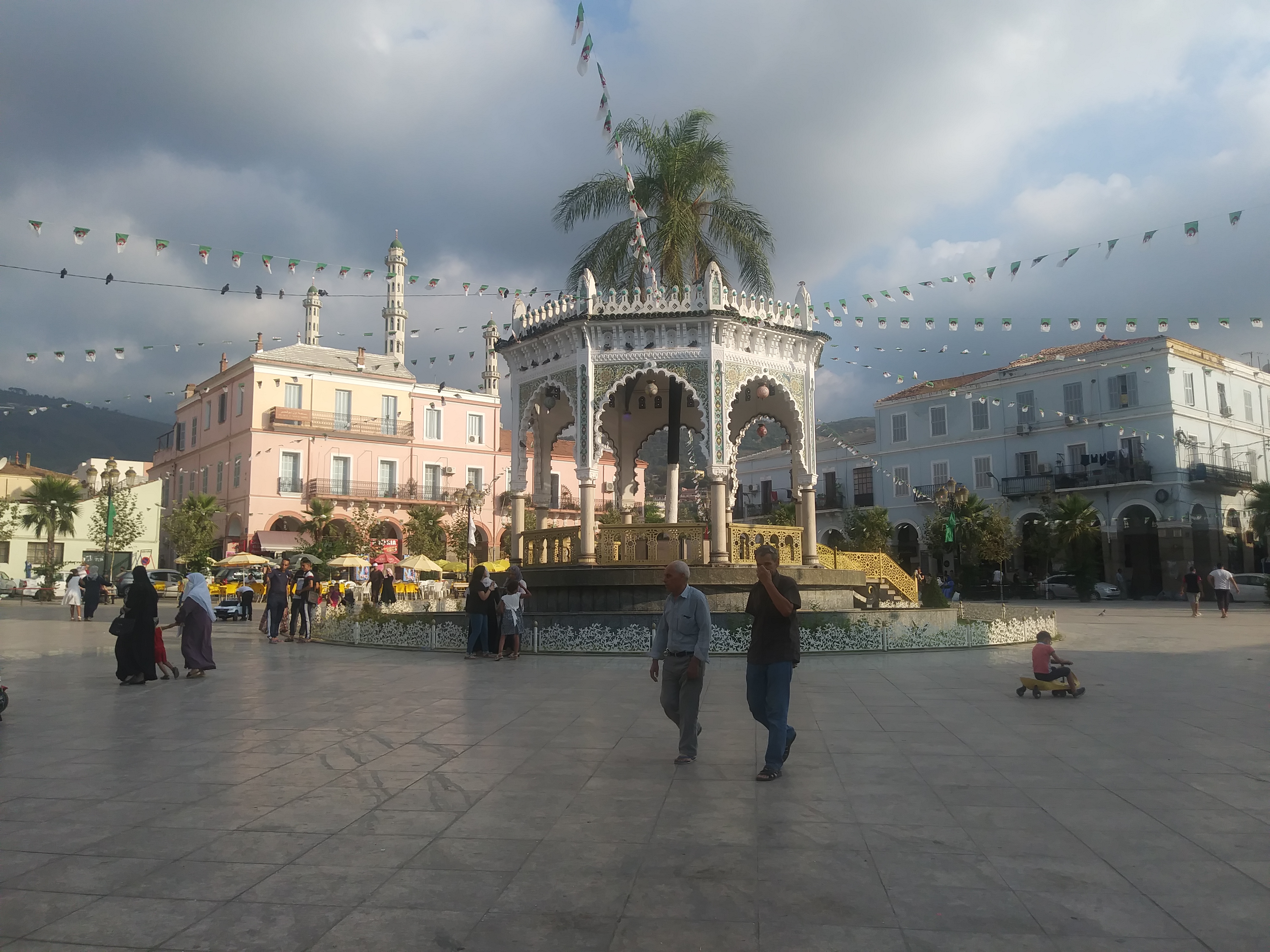
| image4 | Place ettoute بليدة البليدة.png |
| caption4 | Ettoute Square |
| image5 | Mosquee haanafi blida.png |
| caption5 | Hanafi Mosque |
| image6 | El djoun - الجون blida.png |
| caption6 | Douirette Old Quarter |
| image7 | Gorge de chiffa.png |
| caption7 | Chiffa Gorge |
| image8 | Megtaa azrak hammam melouane.jpg |
| caption8 | Hammam Melouane |
| image_caption | Overview of Blida |
| image_seal | Blida Coat of Arms (French Algeria).svg |
| mapframe | yes |
| image_map | DZ - 09-01 - Blida - Wilaya de Blida.svg |
| mapsize | 180px |
| map_caption | Location of Blida, Algeria within Blida Province |
| pushpin_map | Algeria |
| subdivision_type | Country |
| subdivision_name | Algeria |
| subdivision_type1 | Province |
| subdivision_name1 | Blida Province |
| subdivision_type2 | District |
| subdivision_name2 | Blida District |
| area_total_km2 | 72.1 |
| population_as_of | 2012 |
| population_total | 182447 |
| population_urban | 520000 |
| population_metro | 1167882 |
| population_density_km2 | auto |
| demographics_type1 | GDP (PPP, constant 2015 values) |
| demographics1_title1 | Year |
| demographics1_info1 | 2024 |
| demographics1_title2 | Total (Urban) |
| demographics1_info2 | $10.2 billion |
| demographics1_title3 | Per capita |
| demographics1_info3 | $19,500 |
| timezone | CET |
| utc_offset | +1 |
| coordinates | |
| elevation_m | 260 |
| postal_code_type | Postal code |
| postal_code | 09000 |
| area_code | 901 |
| blank_name | Climate |
| blank_info | Csa |
the Algerian city
Blida () is a city in Algeria. It is the capital of Blida Province, and it is located about 45 km south-west of Algiers, the national capital. The name Blida, i.e. bulaydah, is a diminutive of the Arabic word belda, city.
Geography
It gets its name from the classical Arabic word for "small city:" boulayda. Blida is known as the city of roses because of the large number of roses in its gardens.
Blida lies surrounded with orchards and gardens, 190 m above the sea, at the base of the Tell Atlas, on the southern edge of the fertile Mitidja Plain, and the right bank of the Oued el kebir outflow from the Chiffa gorge. The abundant water of this stream provides power for large corn mills and several factories, and also supplies the town with its numerous fountains and irrigated gardens. Within Blida is Chréa National Park, one of the largest national parks in the country and part of the Atlas Mountains. Blida is surrounded by a wall of considerable extent, pierced by six gates, and is further defended by Port Mimieh, crowning a steep hill on the left bank of the river.
The nearby Chiffa gorge is a habitat of the endangered Barbary macaque, Macaca sylvanus; the habitat is one of only a few locations where populations of the primate are found.
Climate
In Blida, there is a Mediterranean climate. The Köppen-Geiger climate classification is Csa. The average annual temperature in Blida is 17.9 °C. About 791 mm of precipitation falls annually.
History

No ancient center preceded the city. It was identified with the town of Mitidja in the Middle Ages which was ruined during the Beni Ghania campaigns. The present town was founded by Moors—principally by Sidi Ahmed El-Kebir—in the 16th century.
The town was rebuilt according to a grid plan following an earthquake in 1825 on a site about a mile distant from the ruins. It numbers among its buildings several mosques and churches, extensive barracks and a large military hospital. The principal square, the place d'Armes, is surrounded by arcaded houses and shaded by trees. The center of a fertile district, and a post on one of the main routes in the country, Blida has a flourishing trade, chiefly in oranges and flour. The orange groves contain over 50,000 trees, and in April the air for miles round is laden with the scent of the orange blossoms. In the public gardens is a group of magnificent olive trees. The products of the neighboring cork trees and cedar groves are a source of revenue to the town. Sidi Ahmed El-Kebir, Blida's founder, is buried in Sidi El-Kebir (an area named after him).
A mosque was built by order of Khair-ed-din Barbarossa, and under the Turks the town was of some importance. It was intricately rebuilt of interconnecting alleyways and streets, and was made accessible through the existing six major gates. The gates were as follows:
- Bab Er-Rahba
- Bab Ed-Zair
- Bab El-Khouikha
- Bab Es-Sebt
- Bab Ez-Zaouia
- Bab El-Kbour
- Bab El-Kseb
Today those gates no longer exist, but their names are still in use by people in Blida as reference points to locate streets, places, schools and businesses.
In 1839, French troops occupied the city and built a military base there. They also built an airbase, a communications center, and a military hospital. During the occupation, Blida was known mainly for its rich farmlands on the Mitidja Plain. Many aspects of life there were racially segregated, including Muslims being compartmentalized into a crowded ghetto and boarding schools enforcing racially segregated dormitories. This occupation lasted until Algeria won its independence from France in the Algerian War.
In 1867, another earthquake damaged Blida.
Blida Province is home to a number of Berber-speaking tribes &towns. The Berbers of Blida are known as Djebailia and have been in the plains of Blida/Matija for thousands of years according to historians such as Ibn khaldoun. The tribes are Beni Salah (Ith salah), Beni Misrah (Ith Misra), Ghalia and many more. They speak Taqbaylit the language of the Kabyle which is the Berber language of blida close to the Kabyle varieties spoken east of Algiers Province, It is 95% identical and has traditionally been seen as an intermediate between Kabyle and the Chenoua language native to the north-eastern part of the country.
Notable locations
-
Stade Mustapha Tchaker in Blida is the current exclusive home stadium for the Algeria national football team. This has been the case since it was opened in 2002, Algeria have however also played many of their home games away from Tchaker throughout their history, both in friendly matches and for competitive tournaments.
-
Al-Kawthar Mosque is located in the center of the city at the Bin Merah Square, known as the famous square of the Toot in Blida. The mosque is distinguished by its space as it attracts more than 12 thousand worshipers on religious occasions.
-
Place Toute is located in the center of Blida located near Bab Es-Sebt, Al-Kawthar Mosque, and the old market. Tourists and locals can enjoy the many cafes, pastry shops, ice cream shops, and other restaurants while their children play in the plaza.
Notable people
- Mhamed Yazid (1923–2003) — politician
- Mahfoud Nahnah (1942–2003) — politician
- (1893–1976) — theologian
- (1941–1993) — politician
- Elissa Rhaïs — novelist
- Edouard Nieuport (1875–1911) — aviation pioneer and manufacturer
- Salah Aougrout — comedian
- Farid Khodja — singer
- Rabah Driassa — singer & painter
- Baya — artist
- Souhila Bel Bahar — painter
- Mohamed Bourouissa – artist
- Frantz Fanon — psychiatrist and writer
- Dahmane Ben Achour — singer
- Ahmed Zahzah — footballer
Notes
References
- Alice Cherki and Nadia Benabid (2006) Frantz Fanon: A Portrait, Cornell University Press, 255 pages
- C. Michael Hogan, (2008) Barbary Macaque: Macaca sylvanus, Globaltwitcher.com, ed. Nicklas Stromberg
References
- "TelluBase—Algeria Fact Sheet (Tellusant Public Service Series)". Tellusant.
- Alice Cherki and Nadia Benabid, 2006
- Shatz, Adam (2024). ''The Rebel's Clinic: The Revolutionary Lives of Frantz Fanon''. Farrar, Straus and Giroux. p. 147. {{ISBN. 978-0374720001.
- C. Michael Hogan, 2008
- (1899). "Arab Market, Blida, Algeria".
- Babo, Daniel. (2010). "Algérie". le Sureau.
- {{EB1911
This article was imported from Wikipedia and is available under the Creative Commons Attribution-ShareAlike 4.0 License. Content has been adapted to SurfDoc format. Original contributors can be found on the article history page.
Ask Mako anything about Blida — get instant answers, deeper analysis, and related topics.
Research with MakoFree with your Surf account
Create a free account to save articles, ask Mako questions, and organize your research.
Sign up freeThis content may have been generated or modified by AI. CloudSurf Software LLC is not responsible for the accuracy, completeness, or reliability of AI-generated content. Always verify important information from primary sources.
Report