From Surf Wiki (app.surf) — the open knowledge base
Biome
Biogeographical unit with a particular biological community

Biogeographical unit with a particular biological community
A biome ( ) is a distinct geographical region with specific climate, vegetation, animal life, and an ecosystem. It consists of a biological community that has formed in response to its physical environment and regional climate. In 1935, Tansley added the climatic and soil aspects to the idea, calling it ecosystem. The International Biological Program (1964–74) projects popularized the concept of biome.
However, in some contexts, the term biome is used in a different manner. In German literature, particularly in the Walter terminology, the term is used similarly as biotope (a concrete geographical unit), while the biome definition used in this article is used as an international, non-regional, terminology—irrespectively of the continent in which an area is present, it takes the same biome name—and corresponds to his "zonobiome", "orobiome" and "pedobiome" (biomes determined by climate zone, altitude, or soil).
In the Brazilian literature, the term biome is sometimes used as a synonym of biogeographic province, an area based on species composition (the term floristic province being used when plant species are considered), or also as synonym of the "morphoclimatic and phytogeographical domain" of Ab'Sáber, a geographic space with subcontinental dimensions, with the predominance of similar geomorphologic and climatic characteristics, and of a certain vegetation form. Both include many biomes in fact.
Classifications
To divide the world into a few ecological zones is difficult, notably because of the small-scale variations that exist everywhere on earth and because of the gradual changeover from one biome to the other. Their boundaries must therefore be drawn arbitrarily and their characterization made according to the average conditions that predominate in them.
A 1978 study on North American grasslands found a positive logistic correlation between evapotranspiration in mm/yr and above-ground net primary production in g/m2/yr. The general results from the study were that precipitation and water use led to above-ground primary production, while solar irradiation and temperature lead to below-ground primary production (roots), and temperature and water lead to cool and warm season growth habit. These findings help explain the categories used in Holdridge's bioclassification scheme (see below), which were then later simplified by Whittaker. The number of classification schemes and the variety of determinants used in those schemes, however, should be taken as strong indicators that biomes do not fit perfectly into the classification schemes created.
Holdridge (1947, 1964) life zones

Main article: Holdridge life zones
In 1947, the American botanist and climatologist Leslie Holdridge classified climates based on the biological effects of temperature and rainfall on vegetation under the assumption that these two abiotic factors are the largest determinants of the types of vegetation found in a habitat. Holdridge uses the four axes to define 30 so-called "humidity provinces", which are clearly visible in his diagram. While this scheme largely ignores soil and sun exposure, Holdridge acknowledged that these were important.
Allee (1949) biome-types
The principal biome-types by Allee (1949):
- Tundra
- Taiga
- Deciduous forest
- Grasslands
- Desert
- High plateaus
- Tropical forest
- Minor terrestrial biomes
Kendeigh (1961) biomes
The principal biomes of the world by Kendeigh (1961):
- Terrestrial
- Temperate deciduous forest
- Coniferous forest
- Woodland
- Chaparral
- Tundra
- Grassland
- Desert
- Tropical savanna
- Tropical forest
- Marine
- Oceanic plankton and nekton
- Balanoid-gastropod-thallophyte
- Pelecypod-annelid
- Coral reef
Whittaker (1962, 1970, 1975) biome-types

Whittaker classified biomes using two abiotic factors: precipitation and temperature. His scheme can be seen as a simplification of Holdridge's; more readily accessible, but missing Holdridge's greater specificity.
Whittaker based his approach on theoretical assertions and empirical sampling. He had previously compiled a review of biome classifications.
Key definitions for understanding Whittaker's scheme
- Physiognomy: sometimes referring to the plants' appearance; or the biome's apparent characteristics, outward features, or appearance of ecological communities or species – including plants.
- Biome: a grouping of terrestrial ecosystems on a given continent that is similar in vegetation structure, physiognomy, features of the environment and characteristics of their animal communities.
- Formation: a major kind of community of plants on a given continent.
- Biome-type: grouping of convergent biomes or formations of different continents, defined by physiognomy.
- Formation-type: a grouping of convergent formations.
Whittaker's distinction between biome and formation can be simplified: formation is used when applied to plant communities only, while biome is used when concerned with both plants and animals. Whittaker's convention of biome-type or formation-type is a broader method to categorize similar communities.
Whittaker's parameters for classifying biome-types
Whittaker used what he called "gradient analysis" of ecocline patterns to relate communities to climate on a worldwide scale. Whittaker considered four main ecoclines in the terrestrial realm.
- Intertidal levels: The wetness gradient of areas that are exposed to alternating water and dryness with intensities that vary by location from high to low tide
- Climatic moisture gradient
- Temperature gradient by altitude
- Temperature gradient by latitude
Along these gradients, Whittaker noted several trends that allowed him to qualitatively establish biome-types:
- The gradient runs from favorable to the extreme, with corresponding changes in productivity.
- Changes in physiognomic complexity vary with how favorable of an environment exists (decreasing community structure and reduction of stratal differentiation as the environment becomes less favorable).
- Trends in the diversity of structure follow trends in species diversity; alpha and beta species diversities decrease from favorable to extreme environments.
- Each growth-form (i.e. grasses, shrubs, etc.) has its characteristic place of maximum importance along the ecoclines.
- The same growth forms may be dominant in similar environments in widely different parts of the world.
Whittaker summed the effects of gradients (3) and (4) to get an overall temperature gradient and combined this with a gradient (2), the moisture gradient, to express the above conclusions in what is known as the Whittaker classification scheme. The scheme graphs average annual precipitation (x-axis) versus average annual temperature (y-axis) to classify biome-types.
Biome-types
- Tropical rainforest
- Tropical seasonal rainforest
- deciduous
- semideciduous
- Temperate giant rainforest
- Montane rainforest
- Temperate deciduous forest
- Temperate evergreen forest
- needleleaf
- sclerophyll
- Subarctic-subalpine needle-leaved forests (taiga)
- Elfin woodland
- Thorn forest
- Thorn scrub
- Temperate woodland
- Temperate shrublands
- deciduous
- heath
- sclerophyll
- subalpine-needleleaf
- subalpine-broadleaf
- Savanna
- Temperate grassland
- Alpine grasslands
- Tundra
- Tropical desert
- Warm-temperate desert
- Cool temperate desert scrub
- Arctic-alpine desert
- Bog
- Tropical fresh-water swamp forest
- Temperate fresh-water swamp forest
- Mangrove swamp
- Salt marsh
- Wetland
Goodall (1974–) ecosystem types
The multi-authored series Ecosystems of the World, edited by David W. Goodall, provides a comprehensive coverage of the major "ecosystem types or biomes" on Earth:
|Terrestrial Ecosystems |Natural Terrestrial Ecosystems |Wet Coastal Ecosystems |Dry Coastal Ecosystems |Polar and Alpine Tundra |Mires: Swamp, Bog, Fen, and Moor |Temperate Deserts and Semi-Deserts |Coniferous Forests |Temperate Deciduous Forests |Natural Grasslands |Heathlands and Related Shrublands |Temperate Broad-Leaved Evergreen Forests |Mediterranean-Type Shrublands |Hot Deserts and Arid Shrublands |Tropical Savannas |Tropical Rain Forest Ecosystems |Wetland Forests |Ecosystems of Disturbed Ground |Managed Terrestrial Ecosystems |Managed Grasslands |Field Crop Ecosystems |Tree Crop Ecosystems |Greenhouse Ecosystems |Bioindustrial Ecosystems |Aquatic Ecosystems |Inland Aquatic Ecosystems |River and Stream Ecosystems |Lakes and Reservoirs |Marine Ecosystems |Intertidal and Littoral Ecosystems |Coral Reefs |Estuaries and Enclosed Seas |Ecosystems of the Continental Shelves |Ecosystems of the Deep Ocean |Managed Aquatic Ecosystems |Underground Ecosystems
Walter (1976, 2002) zonobiomes
The eponymously named Heinrich Walter classification scheme considers the seasonality of temperature and precipitation. The system, also assessing precipitation and temperature, finds nine major biome types, with the important climate traits and vegetation types. The boundaries of each biome correlate to the conditions of moisture and cold stress that are strong determinants of plant form, and therefore the vegetation that defines the region. Extreme conditions, such as flooding in a swamp, can create different kinds of communities within the same biome.
| Number | Zonobiome | Zonal soil type | Zonal vegetation type | ZB I | ZB II | ZB III | ZB IV | ZB V | ZB VI | ZB VII | ZB VIII | ZB IX |
|---|---|---|---|---|---|---|---|---|---|---|---|---|
| Equatorial, always moist, little temperature seasonality | Equatorial brown clays | Evergreen tropical rainforest | ||||||||||
| Tropical, summer rainy season and cooler "winter" dry season | Red clays or red earths | Tropical seasonal forest, seasonal dry forest, scrub, or savanna | ||||||||||
| Subtropical, highly seasonal, arid climate | Serosemes, sierozemes | Desert vegetation with considerable exposed surface | ||||||||||
| Mediterranean, winter rainy season and summer drought | Mediterranean brown earths | Sclerophyllous (drought-adapted), frost-sensitive shrublands and woodlands | ||||||||||
| Warm temperate, occasional frost, often with summer rainfall maximum | Yellow or red forest soils, slightly podsolic soils | Temperate evergreen forest, somewhat frost-sensitive | ||||||||||
| Nemoral, moderate climate with winter freezing | Forest brown earths and grey forest soils | Frost-resistant, deciduous, temperate forest | ||||||||||
| Continental, arid, with warm or hot summers and cold winters | Chernozems to serozems | Grasslands and temperate deserts | ||||||||||
| Boreal, cold temperate with cool summers and long winters | Podsols | Evergreen, frost-hardy, needle-leaved forest (taiga) | ||||||||||
| Polar, short, cool summers and long, cold winters | Tundra humus soils with solifluction (permafrost soils) | Low, evergreen vegetation, without trees, growing over permanently frozen soils |
Schultz (1988) eco-zones
Schultz (1988, 2005) defined nine ecozones (his concept of ecozone is more similar to the concept of biome than to the concept of ecozone of BBC):
- polar/subpolar zone
- boreal zone
- humid mid-latitudes
- dry mid-latitudes
- subtropics with winter rain
- subtropics with year-round rain
- dry tropics and subtropics
- tropics with summer rain
- tropics with year-round rain
Bailey (1989) ecoregions
Robert G. Bailey nearly developed a biogeographical classification system of ecoregions for the United States in a map published in 1976. He subsequently expanded the system to include the rest of North America in 1981, and the world in 1989. The Bailey system, based on climate, is divided into four domains (polar, humid temperate, dry, and humid tropical), with further divisions based on other climate characteristics (subarctic, warm temperate, hot temperate, and subtropical; marine and continental; lowland and mountain).
- 100 Polar Domain
- 120 Tundra Division (Köppen: Ft)
- M120 Tundra Division – Mountain Provinces
- 130 Subarctic Division (Köppen: E)
- M130 Subarctic Division – Mountain Provinces
- 200 Humid Temperate Domain
- 210 Warm Continental Division (Köppen: portion of Dcb)
- M210 Warm Continental Division – Mountain Provinces
- 220 Hot Continental Division (Köppen: portion of Dca)
- M220 Hot Continental Division – Mountain Provinces
- 230 Subtropical Division (Köppen: portion of Cf)
- M230 Subtropical Division – Mountain Provinces
- 240 Marine Division (Köppen: Do)
- M240 Marine Division – Mountain Provinces
- 250 Prairie Division (Köppen: arid portions of Cf, Dca, Dcb)
- 260 Mediterranean Division (Köppen: Cs)
- M260 Mediterranean Division – Mountain Provinces
- 300 Dry Domain
- 310 Tropical/Subtropical Steppe Division
- M310 Tropical/Subtropical Steppe Division – Mountain Provinces
- 320 Tropical/Subtropical Desert Division
- 330 Temperate Steppe Division
- 340 Temperate Desert Division
- 400 Humid Tropical Domain
- 410 Savanna Division
- 420 Rainforest Division
Biome_WWF_System
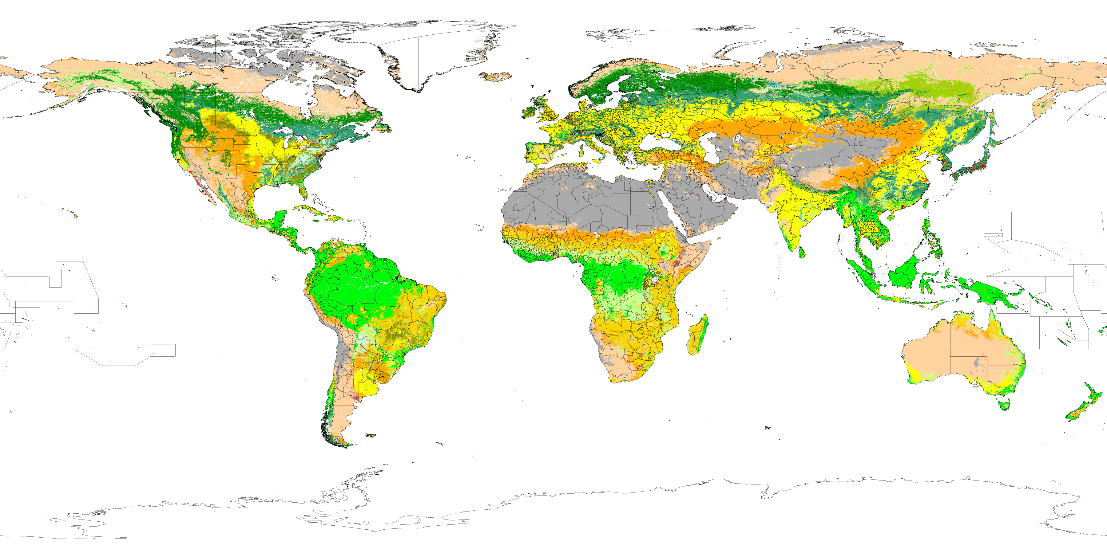
Olson & Dinerstein (1998) biomes for WWF / Global 200
Main article: Global 200

|Terrestrial biomes of the world according to Olson & Dinerstein et al. and used by the WWF and Global 200. ]]
A team of biologists convened by the World Wildlife Fund (WWF) developed a scheme that divided the world's land area into biogeographic realms (called "ecozones" in a BBC scheme), and these into ecoregions (Olson & Dinerstein, 1998, etc.). Each ecoregion is characterized by a main biome (also called major habitat type).
This classification is used to define the Global 200 list of ecoregions identified by the WWF as priorities for conservation.
For the terrestrial ecoregions, there is a specific EcoID, format XXnnNN (XX is the biogeographic realm, nn is the biome number, NN is the individual number).
[[Biogeographic realm]]s (terrestrial and freshwater)

]]
- NA: Nearctic
- PA: Palearctic
- AT: Afrotropic
- IM: Indomalaya
- AA: Australasia
- NT: Neotropic
- OC: Oceania
- AN: Antarctic The applicability of the realms scheme above – based on Udvardy (1975)—to most freshwater taxa is unresolved.
Biogeographic realms ([[Marine ecoregion|marine]])
- Arctic
- Temperate Northern Atlantic
- Temperate Northern Pacific
- Tropical Atlantic
- Western Indo-Pacific
- Central Indo-Pacific
- Eastern Indo-Pacific
- Tropical Eastern Pacific
- Temperate South America
- Temperate Southern Africa
- Temperate Australasia
- Southern Ocean
Biomes (terrestrial)
- Tropical and subtropical moist broadleaf forests (tropical and subtropical, humid)
- Tropical and subtropical dry broadleaf forests (tropical and subtropical, semihumid)
- Tropical and subtropical coniferous forests (tropical and subtropical, semihumid)
- Temperate broadleaf and mixed forests (temperate, humid)
- Temperate coniferous forests (temperate, humid to semihumid)
- Boreal forests/taiga (subarctic, humid)
- Tropical and subtropical grasslands, savannas, and shrublands (tropical and subtropical, semiarid)
- Temperate grasslands, savannas, and shrublands (temperate, semiarid)
- Flooded grasslands and savannas (temperate to tropical, fresh or brackish water inundated)
- Montane grasslands and shrublands (alpine or montane climate)
- Tundra (Arctic)
- Mediterranean forests, woodlands, and scrub or sclerophyll forests (temperate warm, semihumid to semiarid with winter rainfall)
- Deserts and xeric shrublands (temperate to tropical, arid)
- Mangrove (subtropical and tropical, salt water inundated)
Biomes (freshwater)
According to the WWF, the following are classified as freshwater biomes:
- Large lakes
- Large river deltas
- Polar freshwaters
- Montane freshwaters
- Temperate coastal rivers
- Temperate floodplain rivers and wetlands
- Temperate upland rivers
- Tropical and subtropical coastal rivers
- Tropical and subtropical floodplain rivers and wetlands
- Tropical and subtropical upland rivers
- Xeric freshwaters and endorheic basins
- Oceanic islands
Biomes (marine)
Biomes of the coastal and continental shelf areas (neritic zone):
- Polar
- Temperate shelves and sea
- Temperate upwelling
- Tropical upwelling
- Tropical coral
Summary of the scheme
- Biosphere
- Biogeographic realms (terrestrial) (8)
- Ecoregions (867), each characterized by a biome, a major habitat type (14)
- Ecosystems (biotopes)
- Ecoregions (867), each characterized by a biome, a major habitat type (14)
- Biogeographic realms (terrestrial) (8)
- Biosphere
- Biogeographic realms (freshwater) (8)
- Ecoregions (426), each characterized by a biome, a major habitat type (12)
- Ecosystems (biotopes)
- Ecoregions (426), each characterized by a biome, a major habitat type (12)
- Biogeographic realms (freshwater) (8)
- Biosphere
- Biogeographic realms (marine) (12)
- (Marine provinces) (62)
- Ecoregions (232), each characterized by a biome, a major habitat type (5)
- Ecosystems (biotopes)
- Ecoregions (232), each characterized by a biome, a major habitat type (5)
- (Marine provinces) (62)
- Biogeographic realms (marine) (12)
Example:
- Biosphere
- Biogeographic realm: Palearctic
- Ecoregion: Dinaric Mountains mixed forests (PA0418); biome type: temperate broadleaf and mixed forests
- Ecosystem: Orjen, vegetation belt between 1,100 and 1,450 m, Oromediterranean zone, nemoral zone (temperate zone)
- Biotope: Oreoherzogio-Abietetum illyricae Fuk. (Plant list)
- Plant: Silver fir (Abies alba)
- Biotope: Oreoherzogio-Abietetum illyricae Fuk. (Plant list)
- Ecosystem: Orjen, vegetation belt between 1,100 and 1,450 m, Oromediterranean zone, nemoral zone (temperate zone)
- Ecoregion: Dinaric Mountains mixed forests (PA0418); biome type: temperate broadleaf and mixed forests
- Biogeographic realm: Palearctic
Other biomes
Marine biomes
Pruvot (1896) zones or "systems":
- Littoral zone
- Pelagic zone
- Abyssal zone
Longhurst (1998) biomes:
- Coastal
- Polar
- Trade wind
- Westerly
Other marine habitat types (not covered yet by the Global 200/WWF scheme):
- Open sea
- Deep sea
- Hydrothermal vents
- Cold seeps
- Benthic zone
- Pelagic zone (trades and westerlies)
- Abyssal
- Hadal (ocean trench)
- Littoral/Intertidal zone
- Salt marsh
- Estuaries
- Coastal lagoons/Atoll lagoons
- Kelp forest
- Pack ice
Anthropogenic biomes
Humans have altered global patterns of biodiversity and ecosystem processes. As a result, vegetation forms predicted by conventional biome systems can no longer be observed across much of Earth's land surface as they have been replaced by crops and rangelands or cities. Anthropogenic biomes provide an alternative view of the terrestrial biosphere based on global patterns of sustained direct human interaction with ecosystems, including agriculture, human settlements, urbanization, forestry and other uses of land. Anthropogenic biomes offer a way to recognize the irreversible coupling of human and ecological systems at global scales and manage Earth's biosphere and anthropogenic biomes.
|Similarities can be seen between the 14 terrestrial bioregions of Olson & Dinerstein et al. and the 17 land cover classes of the International Geosphere-Biosphere Programme, "which includes 11 natural vegetation classes, 3 developed and mosaicked land classes, and 3 non-vegetated land classes", as detected by satellites. ]]
Major anthropogenic biomes:
- Dense settlements
- Croplands
- Rangelands
- Forested
- Indoor
Microbial biomes
Main article: Microbiome
Endolithic biomes
The endolithic biome, consisting entirely of microscopic life in rock pores and cracks, kilometers beneath the surface, has only recently been discovered, and does not fit well into most classification schemes.
Effects of climate change
Anthropogenic climate change has the potential to greatly alter the distribution of Earth's biomes. Meaning, biomes around the world could change so much that they would be at risk of becoming new biomes entirely. More specifically, between 54% and 22% of global land area will experience climates that correspond to other biomes. 3.6% of land area will experience climates that are completely new or unusual. An example of a biome shift is woody plant encroachment, which can change grass savanna into shrub savanna.
Average temperatures have risen more than twice the usual amount in both arctic and mountainous biomes, which leads to the conclusion that arctic and mountainous biomes are currently the most vulnerable to climate change. South American terrestrial biomes have been predicted to go through the same temperature trends as arctic and mountainous biomes. With its annual average temperature continuing to increase, the moisture currently located in forest biomes will dry up.
References
References
- (2016-09-24}}. Earlier version, 2003, [http://www2.ib.unicamp.br/profs/fsantos/bt682/2003/Apostila-FormasVida-2003.pdf] {{Webarchive). "Ecology". [[Oxford University Press]].
- (2016). "Biogeography: an ecological and evolutionary approach". [[John Wiley & Sons]].
- Tansley, A.G.. (1935). "The use and abuse of vegetational terms and concepts.". [[Ecology (journal).
- Box, E.O. & Fujiwara, K. (2005). Vegetation types and their broad-scale distribution. In: [[Eddy van der Maarel. van der Maarel, E.]] (ed.). ''Vegetation ecology''. Blackwell Scientific, Oxford. pp. 106–128, [https://e.famnit.upr.si/pluginfile.php/14045/mod_resource/content/1/Vegetation%20Ecology.pdf] {{Webarchive. link. (2016-08-28.)
- (2002). "Walter's Vegetation of the Earth: The Ecological Systems of the Geo-Biosphere". [[Springer-Verlag]].
- Coutinho, L. M.. (2006). "O conceito de bioma". [[Acta Botanica Brasilica]].
- Batalha, M.A.. (2011). "The Brazilian cerrado is not a biome.". Biota Neotropica.
- (2009). "Review of plant biogeographic studies in Brazil". [[Journal of Systematics and Evolution]].
- (1995). "The ecozones of the world". Springer.
- (July 1978). "The Structure and Function of Ten Western North American Grasslands: III. Net Primary Production, Turnover and Efficiencies of Energy Capture and Water Use". [[British Ecological Society]].
- (1988). "Concepts of Ecosystem Ecology". [[Springer-Verlag]].
- Allee, W.C.. (1949). "Principles of animal ecology". Saunders Co..
- Kendeigh, S.C.. (1961). "Animal ecology". [[Prentice-Hall]].
- Whittaker, Robert H.. (January–March 1962). "Classification of Natural Communities". [[Botanical Review]].
- (1975). "Communities and Ecosystems". [[MacMillan Publishing]].
- Whittaker, R. H. (1970). ''Communities and Ecosystems''. Toronto, pp. 51–64, [https://books.google.com/books?id=T6m0AAAAIAAJ].
- "Ecosystems of the World". [[Elsevier]].
- Walter, H.. (1976). "Die ökologischen Systeme der Kontinente (Biogeosphäre). Prinzipien ihrer Gliederung mit Beispielen".
- (1991). "Ökologie der Erde".
- Schultz, J. ''Die Ökozonen der Erde'', 1st ed., Ulmer, Stuttgart, Germany, 1988, 488 pp.; 2nd ed., 1995, 535 pp.; 3rd ed., 2002; 4th ed., 2008; 5th ed., 2016. Transl.: ''The Ecozones of the World: The Ecological Divisions of the Geosphere''. Berlin: Springer-Verlag, 1995; 2nd ed., 2005, [https://books.google.com/books?id=V9L8yPzAjxIC].
- "Bailey System". [[US Forest Service]].
- Bailey, R. G.. (1989). "Explanatory supplement to ecoregions map of the continents.". [[Environmental Conservation (journal).
- Olson, D. M. & E. Dinerstein (1998). The Global 200: A representation approach to conserving the Earth's most biologically valuable ecoregions. ''Conservation Biol.'' 12:502–515, [http://planet.uwc.ac.za/nisl/Biodiversity/pdf/OlsonDinerstein1998.pdf] {{Webarchive. link. (2016-10-07.)
- Olson, D. M., Dinerstein, E., Wikramanayake, E. D., Burgess, N. D., Powell, G. V. N., Underwood, E. C., D'Amico, J. A., Itoua, I., Strand, H. E., Morrison, J. C., Loucks, C. J., Allnutt, T. F., Ricketts, T. H., Kura, Y., Lamoreux, J. F., Wettengel, W. W., Hedao, P., Kassem, K. R. (2001). Terrestrial ecoregions of the world: a new map of life on Earth. ''Bioscience'' 51(11):933–938, [http://wolfweb.unr.edu/~ldyer/classes/396/olsonetal.pdf] {{Webarchive. link. (2012-09-17.)
- Abell, R., M. Thieme, C. Revenga, M. Bryer, M. Kottelat, N. Bogutskaya, B. Coad, N. Mandrak, S. Contreras-Balderas, W. Bussing, M. L. J. Stiassny, P. Skelton, G. R. Allen, P. Unmack, A. Naseka, R. Ng, N. Sindorf, J. Robertson, E. Armijo, J. Higgins, T. J. Heibel, E. Wikramanayake, D. Olson, H. L. Lopez, R. E. d. Reis, J. G. Lundberg, M. H. Sabaj Perez, and P. Petry. (2008). Freshwater ecoregions of the world: A new map of biogeographic units for freshwater biodiversity conservation. ''BioScience'' 58:403–414, [http://www.feow.org/downloads/Abell_et_al_08_BioScience.pdf] {{Webarchive. link. (2016-10-06.)
- Spalding, M. D. et al. (2007). Marine ecoregions of the world: a bioregionalization of coastal and shelf areas. ''BioScience'' 57: 573–583, [http://algae.thu.edu.tw/lab/2013_Meeting_FebJune/2007_Marine_ecoregions_of_the_world.pdf] {{Webarchive. link. (2016-10-06 .)
- "Freshwater Ecoregions of the World".
- "Marine Ecoregions of the World".
- Pruvot, G.. (1896). "Conditions générales de la vie dans les mers et principes de distribution des organismes marins: Année Biologique".
- Longhurst, A.. (1998). "Ecological Geography of the Sea". [[Academic Press]].
- "MODIS/Terra+Aqua Land Cover Type Yearly L3 Global 0.05Deg CMG – LAADS DAAC".
- Zimmer, Carl. (March 19, 2015). "The Next Frontier: The Great Indoors". [[The New York Times]].
- "What is the Endolithic Biome? (with picture)".
- (September 29, 2021). "Protected-area targets could be undermined by climate change-driven shifts in ecoregions and biomes". [[Communications Earth & Environment]].
- (2017-12-31). "The Future of Nature". [[Yale University Press]].
- (2018-08-31). "Past and future global transformation of terrestrial ecosystems under climate change". Science.
- (2020-03-03). "Multivariate climate departures have outpaced univariate changes across global lands". Scientific Reports.
- (2007-04-03). "Projected distributions of novel and disappearing climates by 2100 AD". [[Proceedings of the National Academy of Sciences]].
- (January 2017). "Savanna woody encroachment is widespread across three continents". Global Change Biology.
- (2019-03-28). "Editorial: Responses to Climate Change in the Cold Biomes". [[Frontiers in Plant Science]].
- (September 15, 2014). "21st century climate change in the European Alps—A review". [[Science of the Total Environment]].
- (2016-12-01). "Surface air temperature variability and trends in the Arctic: new amplification assessment and regionalisation". [[Tellus A: Dynamic Meteorology and Oceanography]].
- (2021-01-01). "Future projections for terrestrial biomes indicate widespread warming and moisture reduction in forests up to 2100 in South America". [[Global Ecology and Conservation]].
- (2020-12-14). "Global tree-ring analysis reveals rapid decrease in tropical tree longevity with temperature". [[Proceedings of the National Academy of Sciences]].
- (2020-04-30). "Patterns and trends of the dominant environmental controls of net biome productivity". [[Biogeosciences]].
This article was imported from Wikipedia and is available under the Creative Commons Attribution-ShareAlike 4.0 License. Content has been adapted to SurfDoc format. Original contributors can be found on the article history page.
Ask Mako anything about Biome — get instant answers, deeper analysis, and related topics.
Research with MakoFree with your Surf account
Create a free account to save articles, ask Mako questions, and organize your research.
Sign up freeThis content may have been generated or modified by AI. CloudSurf Software LLC is not responsible for the accuracy, completeness, or reliability of AI-generated content. Always verify important information from primary sources.
Report