From Surf Wiki (app.surf) — the open knowledge base
Big Hole River
River in Montana, United States

River in Montana, United States
| Field | Value |
|---|---|
| name | Big Hole River |
| native_name | und |
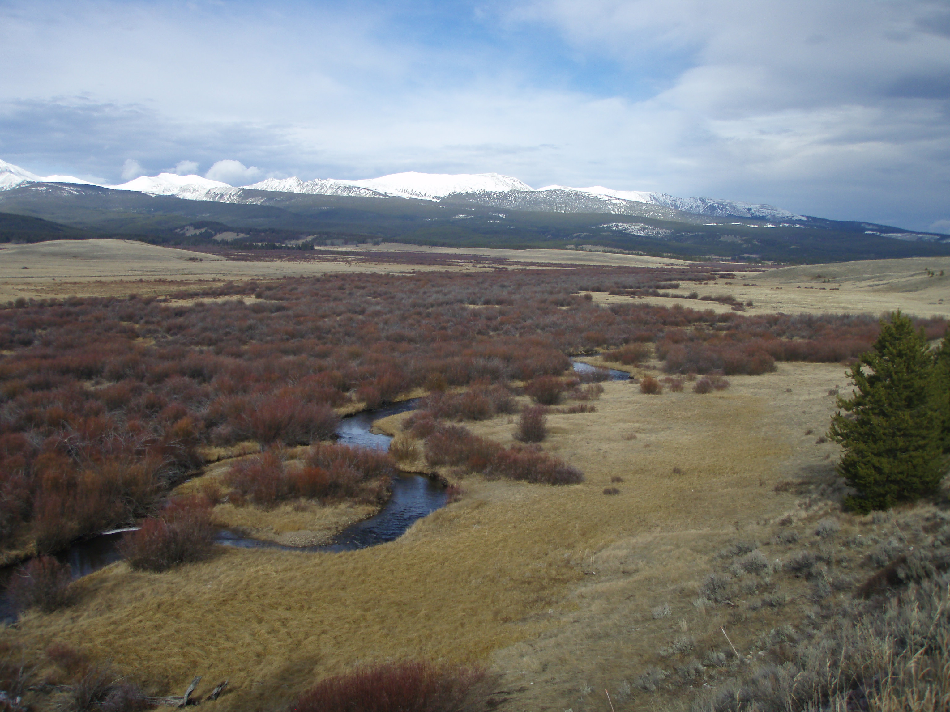
| image | File:BigHoleRiverNearTwinBridges.jpg |
| image_caption | Big Hole River near Twin Bridges, Montana |
| map | Big Hole River Watershed.png |
| map_caption | Map of the Big Hole River watershed |
| pushpin_map | Montana |
| pushpin_map_caption | Location of mouth |
| subdivision_type1 | Country |
| subdivision_name1 | United States |
| subdivision_type2 | State |
| subdivision_name2 | Montana |
| length | 153 mi |
| discharge1_location | near Twin Bridges |
| discharge1_avg | 1250 cuft/s |
| source1_location | Skinner Lake, Bitterroot Range, Montana, Beaverhead |
| source1_coordinates | |
| source1_elevation | 7372 ft |
| mouth | Jefferson River |
| mouth_location | Twin Bridges, Montana |
| mouth_coordinates | |
| mouth_elevation | 4610 ft |
| basin_size | 2800 sqmi |
| tributaries_right | Wise River |

The Big Hole River is a tributary of the Jefferson River, approximately 153 miles (246 km) long, in Beaverhead County, in southwestern Montana, United States. It is the last habitat in the contiguous United States for native fluvial Arctic grayling and is a historically popular destination for fly fishing, especially for trout.
History
At the time the Lewis and Clark Expedition traveled through the Big Hole River watershed, it was a buffer zone between several rival Native American tribes including the Nez Percé, Shoshone, Coast Salish, and Blackfeet. Lewis and Clark considered navigating up the Big Hole River, which they called the Wisdom River, but chose the slower-flowing Beaverhead River instead. Trappers from both the Hudson's Bay Company, the North West Company and the American Fur Company exploited the region from about 1810 to the 1840s. Miners and homesteaders settled the area between 1864 and the early 1900s. The Montana Salish called the river Sk͏ʷumcné Sewɫk͏ʷs, meaning "waters of the pocket gopher".
In 1877 the U.S. troops under John Gibbon fought the Nez Percé indigenous Americans along the Big Hole River, during the Nez Perce War in the Battle of the Big Hole. The site of the battle along the North fork of the Big Hole is preserved as the Big Hole National Battlefield.
The establishment of Butte, Montana as a mining center and the coming of the Northern Railroad in 1871 assured Big Hole ranchers and farmers of a steady market for their beef, horses, mules, hay and dairy products. Ranches grew along the river from railroad supply points such as Divide, Montana. As a great improvement for preserving the wild hay for winter feeding of cattle, Herbert S. Armitage and David J. Stephens filed for a "Hay-Stacker" patent in 1909, which was awarded in 1910. This device, commonly known as a "beaverslide" remained popular until the 1990s, when it was largely displaced by mechanized equipment for producing large round bales.
Watershed and course
The Big Hole River watershed drains 2,800 sqmi.
The source of the mainstem Big Hole River is Skinner Lake in the Beaverhead National Forest in the Beaverhead Mountains of the Bitterroot Range at the Continental Divide along the Montana-Idaho border in western Beaverhead County. However, Skinner Lake is in turn fed by Darkhorse Creek, which flows from Darkhorse and Cowbone Lakes, the former at 8691 ft. The Big Hole River flows northwest and north, past Wisdom and between the Anaconda Range to the northwest and the Pioneer Mountains to the east.
It flows around the north end of the Pioneers where it forms the border between Beaverhead County and Deer Lodge County and then Silver Bow County, then southeast past the town of Wise River, Montana, where it is joined by the Wise River. Near Glen, Montana it turns northeast and joins the Beaverhead River near Twin Bridges to form the Jefferson River, a tributary of the Missouri.
Ecology and conservation
Historic conflicts exist between ranchers in the valley who use the river for irrigation and recreationalists. In the early 1960s, the US Bureau of Reclamation proposed building the Reichle Dam near the town of Glen along the Big Hole River. Conservationist George F. Grant, Trout Unlimited and local ranchers combined forces to oppose the dam, successfully defeating the proposal in 1967.
Grayling
The Big Hole is the last habitat in the contiguous United States for native fluvial (river-dwelling) Arctic grayling (Thymallis arcticus). Fluvial Arctic grayling lived historically in the United States only in Michigan and the upper Missouri River above Great Falls, Montana. Adfluvial or lake-dwelling Arctic grayling, still thrive across the western half of Montana. The fluvial population comprises the Upper Missouri River distinct population segment (DPS) population. The two populations are commonly called Montana Arctic grayling.
After years of debate by all interests in the Big Hole watershed, in April 2007, the U.S. Fish and Wildlife Service (USFWS) removed the fluvial Arctic Grayling from Endangered Species candidacy, which has resulted in a lawsuit by the Center for Biological Diversity and other interested parties, who have stated the view that the USFWS decision was politically mandated by Julie MacDonald, the former Department of Interior official who has since resigned. An Office of the Inspector General investigation found that "MacDonald has been heavily involved with editing, commenting on, and reshaping the Endangered Species Program's scientific reports." In the case of grayling, MacDonald ignored clear genetic differences between extremely rare fluvial (river) grayling and relatively common lacustrine (lake) grayling. In 2014, The USFWS again affirmed that local conservation efforts are sufficient to protect the grayling, and declined to list the DPS of the grayling as federally endangered.
An environmental DNA assay using tissue samples from grayling in the Bighole River can identify grayling with high specificity against other native and non-native salmonids in Montana.
Angling the Big Hole
The Big Hole river has been a destination for trout fisherman since the late 1880s when The Angler's Guide, an Eastern angling journal advertised the Big Hole as a national destination fishery for grayling and trout while promising daily 40 lb catches. Although the river still holds some native westslope cutthroat trout, their populations are almost non-existent. Instead, the river holds healthy wild populations of brook, rainbow and brown trout which were first introduced into the Big Hole in late 1880s as hatchery operations began in Butte and Bozeman, Montana. Native mountain whitefish are also prevalent in the river. In the 1980s, the state of Montana began stopping general stocking of all Montana rivers. The last hatchery fish were stocked in the Big Hole in 1990. Dozens of guides, outfitters and fishing lodges offer guided fishing on the Big Hole and its tributaries. The river is catch and release for brown trout (Dickey bridge to mouth)
The river is a Class I water from the Fishtrap fishing access site downstream from Wisdom to its confluence with the Jefferson River. This status affects the level of public access for recreational purposes.
| Section | width=40% | Description | width=35% | Prevalent Species | ||
|---|---|---|---|---|---|---|
| Skinner Lake (Headwaters), Wisdom, MT to Fish Trap (River Mile 81) | ||||||
| Fish Trap to Melrose | ||||||
| Melrose to Twin Bridges, MT |
Notes
References
- Montana Department of Natural Resources & Conservation (1995). "Measuring Devices on the Big Hole River" (Helena, Montana: Department of Natural Resources & Conservation).
- Ted Williams, "Who Needs Grayling?" Fly Rod & Reel (November/December 2007): 18–24.
References
- "USGS Surface Water data for Montana: USGS Surface-Water Annual Statistics".
- {{gnis. 779824. Big Hole River
- {{cite gnis. 790957. Skinner Lake
- "Arctic Grayling - Endangered Species of the Mountain-Prairie Region". U. S. Fish and Wildlife Service.
- [https://www.mtmemory.org/nodes/view/127486 "Big Hole River", Montana State Library]
- (2014). "Salish Audio Files". Salish-Pend d'Oreille Culture Committee.
- Greene, Jerome A.. (2000). "Nez Perce Summer, 1877-The U.S. Army and the Nee-Me-Poo Crisis". Montana Historical Society Press.
- ""Divide", Montana Official Travel Site".
- Big Hole Watershed Committee. (2012-11-01). "Big Hole River Watershed, Montana Watershed Restoration Plan - Upper and North Fork Watershed".
- Big Hole Watershed Committee. (2013-08-29). "Big Hole River, Montana Watershed Restoration Plan - Middle and Lower Watershed".
- {{cite gnis. 782088. Darkhorse Creek
- McLean, Bryce. "Drone Shot of the Big Hole River".
- (February 2022). "Big Hole River". Big Sky Fishing.com.
- "Big Hole River Drainage".
- The Big Hole River Watershed Committee (BHWC) was formed in 1995 by several Big Hole ranchers and some factions of the conservation community who opposed an ESA listing for fluvial Arctic grayling. The Watershed Committee reached out to local and selected interested entities and developed a viable community-based consensus group to forge solutions to difficult problems that impact the river. The committee was criticized for exclusion of activist voices such as the [[Center for Biological Diversity]] and the Montana Wildlife Federation. In response, organizations such as the Big Hole River Foundation were formed, with the goal "to understand, preserve, and enhance the free flowing character of the Big Hole River and to protect its watershed, culture, community and excellent wild trout fishery."[http://www.bhrf.org/ The Big Hole River Foundation Website]
- [http://www.biologicaldiversity.org/swcbd/press/grayling-05-15-2007.html CBD Press Release]
- "Who Needs Grayling? - Ted Williams - October 2007 - national".
- K. J. Carim. (2016). "An environmental DNA assay for detecting Arctic grayling in the upper Missouri River basin, North America". Conservation Genetics Resources.
- Munday, Pat. (2001). "Montana's Last Best River: The Big Hole & its People". Lyons Press.
- Munday, Pat. (2001). "Montana's Last Best River: The Big Hole & its People". Lyons Press.
- "New Brown Trout Regulations in-place on Big Hole Beaverhead rivers". Montana Fish Wildlife and Parks.
- link. (2009-03-10)
- Munday, Pat. (2001). "Montana's Last Best River: The Big Hole & its People". Lyons Press.
- [http://fwp.mt.gov/fishing/guide/report.aspx?llid=1123386455678 Montana Fish, Wildlife and Parks - Big Hole River]
This article was imported from Wikipedia and is available under the Creative Commons Attribution-ShareAlike 4.0 License. Content has been adapted to SurfDoc format. Original contributors can be found on the article history page.
Ask Mako anything about Big Hole River — get instant answers, deeper analysis, and related topics.
Research with MakoFree with your Surf account
Create a free account to save articles, ask Mako questions, and organize your research.
Sign up freeThis content may have been generated or modified by AI. CloudSurf Software LLC is not responsible for the accuracy, completeness, or reliability of AI-generated content. Always verify important information from primary sources.
Report