From Surf Wiki (app.surf) — the open knowledge base
Bicas

| Field | Value |
|---|---|
| official_name | Bicas |
| image_skyline | File:Brasil.mg.bicas-foto.aerea.1995-2.jpg |
| imagesize | 250px |
| image_caption | View of Bicas |
| image_flag | File:Bandeira de Bicas.png |
| image_seal | File:Brasão de Bicas.png |
| image_map | MinasGerais Municip Bicas.svg |
| map_caption | Location in Brazil |
| pushpin_map | Brazil |
| subdivision_type | Country |
| subdivision_type1 | Region |
| subdivision_type2 | State |
| subdivision_name | Brazil |
| subdivision_name1 | Southeast |
| subdivision_name2 | Minas Gerais |
| subdivision_type3 | Mesoregion |
| subdivision_name3 | Zona da Mata |
| subdivision_type4 | Microregion |
| subdivision_name4 | Juiz de Fora |
| leader_title | Mayor |
| leader_name | Geraldo Magela Longo dos Santos |
| established_title | Founded |
| established_date | September 7th, 1923 |
| area_total_km2 | 139,538 |
| area_footnotes | |
| population_as_of | 2020 |
| population_total | 14,554 |
| timezone | BRT |
| utc_offset | −3 |
| coordinates | |
| elevation_m | 600.0 |
| blank_name | HDI (2000) |
| blank_info | 0.799 |
| website | Bicas, Minas Gerais |
Bicas is a Brazilian municipality in the state of Minas Gerais. its population is estimated to be 14,554 inhabitants.
History
Originally, a stopping point for salesmen in the 18th century, Bicas gained its independence from the city of Guarará in 1923. It served as a destination for Italian immigrants and other nationalities.
Until the 1970s, Bicas had a full-working train station and an active RFFSA (the extinct state railroad company) branch for repairing wagons. The entire structure was dismantled and today the train station exists only as a historic site. Currently, Bicas has an economy based on commerce, agriculture and farming.
Annual Farming Expositions, with bull-riding and rodeos, cattle commerce and local products - typically in the last week of July of every year - are a tradition of several cities in Zona da Mata, and the Farming Exposition of Bicas is one of the most famous, attracting thousands of tourists from several parts of the country.
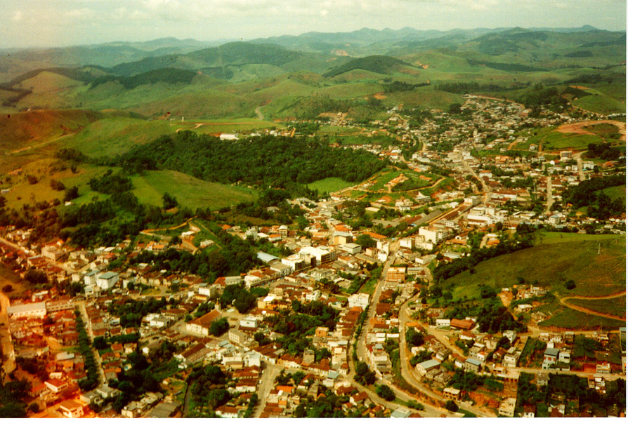
Aerial view of Bicas, in 1995, towards west, showing the city centre and Cruzeiro hill (in the middle), the region of the farming exposition (on the right side) and the highlands (on the left side). Bicas, like many other cities in Zona da Mata region of Minas Gerais state, is surrounded by the typical local geographical relief known as "sea of hills". ]]
Notable people
- Danilo Football player
Aerial photos
File:P217r75 5t19930624 bicas rgb bandas 321.png|Satellite photo, 1993-06-24, real colour. File:P217r75 5t19930624 bicas rgb bandas 321 realcado.png|Satellite photo, 1993-06-24, real colour, sharpened to show smaller roads and details. File:P217r75 5t19930624 bicas rgb bandas 432.png|Satellite photo, 1993-06-24, highlighting dense wood covering (bright red), grass (brown) and buildings (green) File:P217r75 5t19930624 bicas rgb bandas 341.png|Satellite photo, 1993-06-24, strongly contrasting dense wood covering (green), grass (brown), buildings (purple) and naked land areas (orange) File:P217r75 5t19930624 nn1 plus nn3 bicas ressaltando construcoes ENHANCED.png|Satellite photo, 1993-06-24, showing buildings and roads (light grey)
References
References
- (2002-10-10). "Área territorial oficial". [[Brazilian Institute of Geography and Statistics.
- [https://cidades.ibge.gov.br/brasil/mg/bicas/panorama IBGE 2020]
This article was imported from Wikipedia and is available under the Creative Commons Attribution-ShareAlike 4.0 License. Content has been adapted to SurfDoc format. Original contributors can be found on the article history page.
Ask Mako anything about Bicas — get instant answers, deeper analysis, and related topics.
Research with MakoFree with your Surf account
Create a free account to save articles, ask Mako questions, and organize your research.
Sign up freeThis content may have been generated or modified by AI. CloudSurf Software LLC is not responsible for the accuracy, completeness, or reliability of AI-generated content. Always verify important information from primary sources.
Report