From Surf Wiki (app.surf) — the open knowledge base
Bermel Escarpment
Geologic feature in Antarctica
Geologic feature in Antarctica
| Field | Value |
|---|---|
| range | |
| country | Antarctica |
| country_type | Continent |
| subdivision2_type | Region |
| subdivision2 | Ellsworth Land |
| map | Antarctica |
| coordinates |
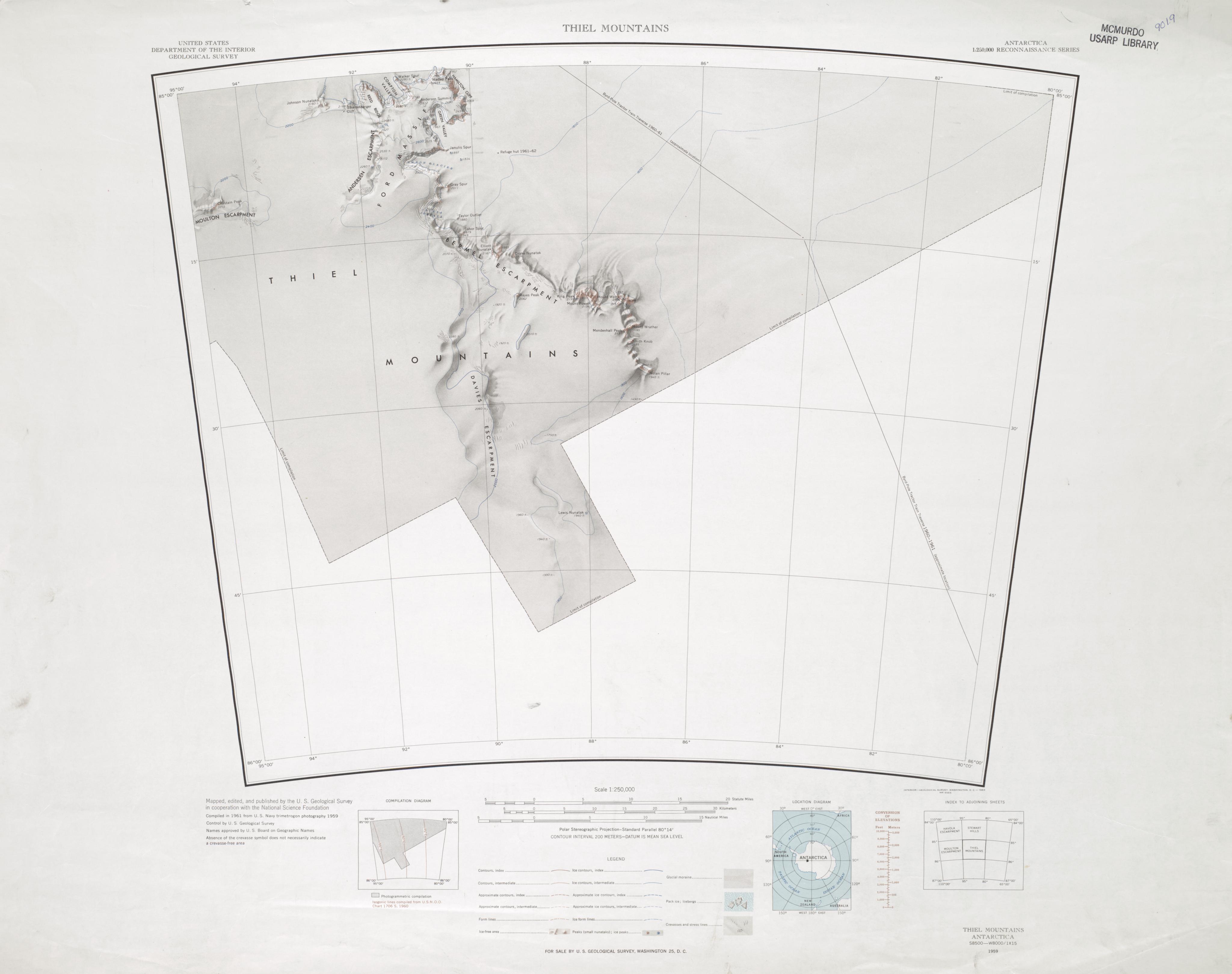
The Bermel Escarpment is a snow and rock escarpment, 15 nmi long, extending from the base of the Ford Massif to King Peak, in the Thiel Mountains of Antarctica. The escarpment drops 300 to from the Antarctic Plateau to the ice surface north of these mountains.
Discovery and naming
The Bermel Escarpment was named by the United States Advisory Committee on Antarctic Names (US-ACAN) after Peter F. Bermel, a cartographer with the United States Geological Survey (USGS). Bermel was co-leader (with Arthur B. Ford) of the USGS Thiel Mountains party which surveyed the mountains in 1960–61, and also leader of USGS Topo East and Topo West, 1962–63, in which geodetic control was extended from the area of Cape Hallett to the Wilson Hills (Topo West), and from the foot of Beardmore Glacier through the Horlick Mountains (Topo East).
Location
The Bermel Escarpment extends southeast from the Counts Icefall, which separates it from the Ford Massif to the north. It faces northeast, dropping from the polar plateau. Features from northwest to southeast include Taylor Outlier, Tabor Spur, Elliot Nunatak, Drake Nunatak and King Peak. A small massif extends the escarpment to the south and includes Mount Powell, Mount Walcott, Mount Wrather, Mendenhall Peak, Smith Knob and Nolan Pillar.
Features
Taylor Outlier
Tabor Spur
Elliot Nunatak
Drake Nunatak
Hayes Peak
King Peak
File:Clarence King.jpg|Clarence Rivers King (1842–1901) File:John Wesley Powell.jpg|John Wesley Powell File:Charles Doolittle Wallcott in 1873.JPG|Charles Doolittle Wallcott in 1873 File:Vincent Ellis McKelvey.jpg|Vincent Ellis McKelvey File:William Embry Wrather.jpg|William Embry Wrather File:Walter Curran Mendenhall 05.jpg|Walter Curran Mendenhall File:George Otis Smith 05.jpg|George Otis Smith File:Thomas Brennan Nolan.jpg|Thomas Brennan Nolan
Southern massif
The names of features in this massif were proposed by Peter Bermel and Arthur Ford, co-leaders of the USGS Thiel Mountains party which surveyed these mountains in 1960-61.
Mount Powell
Mount Walcott
Mount McKelvey
Mount Wrather
Mendenhall Peak
Smith Knob
Nolan Pillar
References
Sources
- {{citation|url=https://pubs.usgs.gov/fedgov/70039167/report.pdf |accessdate=2023-12-03 |edition=2 |editor-last=Alberts |editor-first=Fred G. |title=Geographic Names of the Antarctic
- {{citation |url=https://commons.wikimedia.org/wiki/File:Thiel_Mountains_USGS.jpg |accessdate=2024-01-17
This article was imported from Wikipedia and is available under the Creative Commons Attribution-ShareAlike 4.0 License. Content has been adapted to SurfDoc format. Original contributors can be found on the article history page.
Ask Mako anything about Bermel Escarpment — get instant answers, deeper analysis, and related topics.
Research with MakoFree with your Surf account
Create a free account to save articles, ask Mako questions, and organize your research.
Sign up freeThis content may have been generated or modified by AI. CloudSurf Software LLC is not responsible for the accuracy, completeness, or reliability of AI-generated content. Always verify important information from primary sources.
Report