From Surf Wiki (app.surf) — the open knowledge base
Benue River
Tributary of the Niger River in Cameroon and Nigeria

Tributary of the Niger River in Cameroon and Nigeria
| Field | Value | ||||
|---|---|---|---|---|---|
| name | Benue River | ||||
| subdivision_type1 | Countries | ||||
| subdivision_name1 | |||||
| length | 1,440 km | ||||
| width_avg | 488–976 m(Middle and Lower Benue) | ||||
| width_max | 1.6 km(Lokoja) | ||||
| discharge1_location | Lokoja | ||||
| discharge1_avg | 3,477 m3/s{{refn | name=discharge1 | group=n | Multiannual average: 3,477 m³/s,{{cite web | url= |
| https://openknowledge.fao.org/server/api/core/bitstreams/a6d389bc-ec44-4404-baa1-d6ab33c458c8/content/x5524e04.htm | title | 3. The hydrological cycle and its components}} 3,400 m³/s (1914–1957),[ | |||
| https://documents1.worldbank.org/curated/en/187941468097179065/pdf/345180PAPER0NR1Basin01OFFICIAL0USE1.pdf](PDF; 5,39 MB)</ref> 3,244 m³/s (1970–2009),<ref name | "THE PROJECT FOR | ||||
| MASTER PLAN">https://openjicareport.jica.go.jp/pdf/12146569.pdf</ref> 4,580 m³/s (2010–2024)<ref name | "NIHSA"/}} | ||||
| discharge2_location | Makurdi | ||||
| discharge2_min | 240 m3/s | ||||
| discharge2_avg | 3,150 m3/s | ||||
| discharge2_max | 12,000 m3/s | ||||
| discharge3_location | Numan | ||||
| discharge3_min | 30 m3/s | ||||
| discharge3_avg | 900 m3/s | ||||
| discharge3_max | 5,000 m3/s | ||||
| discharge4_location | Yola, Jimeta | ||||
| discharge4_min | 20 m3/s | ||||
| discharge4_avg | 741 m3/s | ||||
| discharge4_max | 4,200 m3/s | ||||
| discharge5_location | Garoua | ||||
| discharge5_min | 0.4 m3/s | ||||
| discharge5_avg | 360 m3/s{{refn | name=discharge5 | group=n | Multiannual average: 360 m³/s (1930–1981), 451.85 m³/s (1930–1995) | |
| discharge5_max | 3,100 m3/s | ||||
| source1_location | Adamawa Plateau | ||||
| source1_coordinates | |||||
| source1_elevation | 1,340 m | ||||
| mouth | Niger River | ||||
| mouth_location | Lokoja, Nigeria | ||||
| mouth_coordinates | |||||
| mouth_elevation | 35 m | ||||
| progression | Niger→Gulf of Guinea | ||||
| river_system | Niger River | ||||
| basin_size | 319,000–338,200 km2 | ||||
| tributaries_right | Mayo Oldiri, Mayo Rey, Mayo Godi, Mayo-Kébi, Mayo Tiel, Kilunga, Gongola, Pai, Duchi, Wase, Shemanker, Ankwe, Guma, Mada, Okwa | ||||
| tributaries_left | Mayo Farda, Faro, Ini, Belwa, Fan, Taraba, Donga, Katsina-Ala, Gwer |
https://openknowledge.fao.org/server/api/core/bitstreams/a6d389bc-ec44-4404-baa1-d6ab33c458c8/content/x5524e04.htm|title=3. The hydrological cycle and its components}} 3,400 m³/s (1914–1957),[ https://documents1.worldbank.org/curated/en/187941468097179065/pdf/345180PAPER0NR1Basin01OFFICIAL0USE1.pdf](PDF; 5,39 MB) 3,244 m³/s (1970–2009), REVIEW AND UPDATE OF NIGERIA NATIONAL WATER RESOURCES MASTER PLAN"https://openjicareport.jica.go.jp/pdf/12146569.pdf(PDF; 9,62 MB) 4,580 m³/s (2010–2024)}} the headwaters of the Benue River Basin, Northern Cameroon."https://dicames.online/jspui/bitstream/20.500.12177/7754/1/FS_These_BC21_0105.pdf(PDF; 10,02 MB)}}
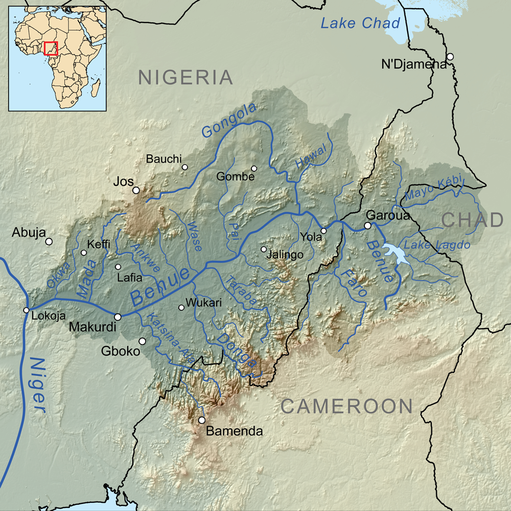
Benue River (), previously known as the Chadda River or Tchadda, is the major tributary of the Niger River. The size of its catchment basin is 319,000 km2. Almost its entire length of approximately 1,400 km is navigable during the summer months. As a result, it is an important transportation route in the regions through which it flows. The name Benue comes from Binuwe, meaning 'Mother of Waters’ in the Batta language.
Geography
The Benue rises in the Adamawa Plateau of northern Cameroon, from where it flows west, and through the town of Garoua and Lagdo Reservoir, into Nigeria south of the Mandara mountains, and through Jimeta, Ibi and Makurdi before meeting the Niger River at Lokoja.
Large tributaries are the Faro, the Gongola and the Mayo Kébbi, which connects it with the Logone (part of the Lake Chad system) during floods. Other tributaries include Taraba, Donga and Katsina Ala.
At the point of confluence, the Benue exceeds the Niger by volume. The mean discharge before 1960 was 3,400 m3/s for the Benue and 3,000 m3/s for the Niger.
Climate
Benue State has a tropical savanna climate. It is warm every month of the year throughout both wet and dry seasons. The annual temperature is 34 °C and there is about 244 inch of rain in a year. The state has an average humidity of 61%, dew point of 25 °C, an UV-index of 7 and it is mainly dry for 169 days in a year.
Major floods
Nigeria’s National Emergency Management Agency (NEMA), conducted a “disaster risk management analysis” and advised Ministries, Departments, and Agencies (MDAs) to take proactive steps to mitigate the impact of climate change. The agency advised that water bodies across some states be desilted and dredged regularly to make water available for various purposes. The agency urged relevant institutions to carry out routine monitoring of dams and water bodies to ensure their operation rule curve for reservoirs is adhered to.
2022 Flood
On September 23, 2022, flooding affected all riverine local government areas of Benue, according to the state Commissioner for Water Resources and Environment, Godwin Oyiwona. The flooding affected Makurdi, Agatu, Logo, Guma, Buruku, Otukpo, and Gwer-West. The government worked to mitigate flooding effects and released funds for cleaning the Idye Basin.
In October 2022, farmers in Adamawa State struggled to clear off remnants of crops destroyed by the flooding. The disaster disrupted many communities across Nigeria’s 36 states, with hundreds of villages and urban centers submerged in water. The disaster unsettled over 2.4 million people and over 600 fatalities were recorded. Additionally, "expansive hectares of farmlands across affected states were swept off."
The worst hit were mostly residents of agrarian communities near major tributaries in seven of the 21 local government areas in the state. Within three months, 12 Local Government Areas (LGAs) were submerged, affecting 82,730 residents, 13,788 households, 51 people injured, and 27 deaths. Farmlands worth billions of naira were destroyed.
January 2020
President Muhammadu Buhari inaugurated a 3.35-km drainage channel project in Makurdi, Benue, to address ecological challenges in the Idye Community. The project, part of the 17 ecological intervention projects, was approved by the President in the fourth quarter of 2017 and completed in 48 weeks. The project aimed to address the devastating effects of erosion and flood in the region.
2017 Flood
News Agency of Nigeria (NAN) reported that Idye Community was among the worst-hit areas of the 2017 flood that displaced over 120,000 persons in the Benue capital, Makurdi. Floods devastated more than 200 households in Makurdi.
2012 Flood
The Benue River flooded in October 2012, resulting in a large increase in the population of venomous snakes in the Duguri District, Alkaleri Local Government Area, Bauchi State. A July 2013 report indicated that over 200 people in the district had died of snakebite. The General Hospital in Kaltungo, Gombe State in Nigeria, is the nearest location for treatment of snakebite; "whoever is lucky to make it to Kaltungo is treated in only two days and then they return home."{{Cite web | access-date = May 11, 2014 File:Drone view Benoue.jpg|Benoue huts File:Drone view at Benoue.jpg|Benoue view from drone File:Traversée de la Benoué à pirogue.jpg|Crossing the Benue River from Lagdo with a Canoe
Pollution
Benue Hike Tourism and Conservation Foundation, in an attempt to keep the river protected from various forms of pollution, informed the Benue State Government about the irregularities of some companies in the state for emptying waste in the river. Waste like ethanol, that could easily cause damage to human and aquatic life, was dumped into Benue River. Subsequently, the Benue State Government took an immediate attempt in addressing the issue to prevent further damages for its citizenry.
Notes
References
References
- "NIHSA".
- [https://cgspace.cgiar.org/server/api/core/bitstreams/88e59f9a-8a9a-4cb3-8ee8-d25f313c7987/content](PDF; 845,82 KB)
- [https://horizon.documentation.ird.fr/exl-doc/pleins_textes/pleins_textes_5/b_fdi_31-32/32981.pdf](PDF; 1,55 MB)
- [https://openjicareport.jica.go.jp/pdf/12146569.pdf](PDF; 9,62 MB)
- [https://papers.ssrn.com/sol3/Delivery.cfm/r71f1156a-2324-41ca-b6c4-1af2e22ec722-MECA.pdf?abstractid=5802540&mirid=1](PDF; 17,05 MB)
- [https://horizon.documentation.ird.fr/exl-doc/pleins_textes/divers14-11/17005.pdf](PDF; 8,7 MB)
- [http://www.hydrosciences.fr/sierem/Bibliotheque/biblio/Cameroun.pdf](PDF; 58,86 MB)
- [https://dicames.online/jspui/bitstream/20.500.12177/7754/1/FS_These_BC21_0105.pdf](PDF; 10,02 MB)
- "Benue River | Nigeria, Cameroon, Chad | Britannica".
- "HydroSciences Montpellier".
- Babangida, Abdulkareem Mojeed, Mohammed. (December 16, 2022). "SPECIAL REPORT: How poor infrastructure worsened flood disasters in states across Nigeria".
- (April 5, 2023). "Benue River".
- Njeuma, Martin Zachary. (1969). "THE RISE AND FALL OF FULANI RULE IN ADAMAWA 1809 - 1901". University of London.
- "Katsina Ala River {{!}} river, western Africa {{!}} Britannica".
- "Benue weather and climate ☀️ Best time to visit 🌡️ Temperature".
- "Weather for Makurdi, Benue, Nigeria".
- Nseyen, Nsikak. (September 19, 2022). "Flooding: NEMA issues warning to Adamawa, Taraba, Benue, others".
- Simire, Michael. (September 23, 2022). "Flooding hits riverine areas in Benue".
- (September 23, 2022). "Flooding hits riverine areas in Benue".
- (January 3, 2020). "Buhari inaugurates 3.35km drainage in Benue".
- (January 3, 2020). "Buhari Inaugurates 3.35km Drainage In Benue".
- Nigeria, News Agency of. (August 28, 2022). "Floods ravage Benue villages as Governor Ortom lounges in Europe".
- Report, Agency. (September 14, 2022). "Floods destroy 200 households in Makurdi".
- "Snakes kill over 200 people in Bauchi council, as government takes no action".
- (June 22, 2021). "Bauchi residents groan over snakebites".
- Orsar, Hembadoon. (April 18, 2023). "Benue River Pollution: You Have Failed, Ortom Tells 3 Commissioners". [[Leadership (newspaper).
- Charles, John. (2023-04-17). "Ortom orders firm's probe for alleged River Benue pollution".
- Sunday, Ochogwu. (2023-04-17). "Biotech company accused of polluting River Benue with cassava plant waste".
This article was imported from Wikipedia and is available under the Creative Commons Attribution-ShareAlike 4.0 License. Content has been adapted to SurfDoc format. Original contributors can be found on the article history page.
Ask Mako anything about Benue River — get instant answers, deeper analysis, and related topics.
Research with MakoFree with your Surf account
Create a free account to save articles, ask Mako questions, and organize your research.
Sign up freeThis content may have been generated or modified by AI. CloudSurf Software LLC is not responsible for the accuracy, completeness, or reliability of AI-generated content. Always verify important information from primary sources.
Report