From Surf Wiki (app.surf) — the open knowledge base
Bengkulu
Province in Sumatra, Indonesia

Province in Sumatra, Indonesia
| Field | Value |
|---|---|
| name | Bengkulu |
| official_name | Province of Bengkulu |
| {{nobold | Provinsi Bengkulu}} |
| translit_lang1 | Other |
| translit_lang1_type1 | Rejang |
| translit_lang1_info1 | ꤷꥍꥏꤰꥈꤾꥈ |
| translit_lang1_type2 | Jawi |
| translit_lang1_info2 | بڠكولو |
| type | Province |
| image_shield | Coat of arms of Bengkulu.svg |
| shield_link | Armorial of Indonesia#Provincial |
| shield_size | 90 |
| image_map | Bengkulu in Indonesia.svg |
| map_caption | |
| established_title | Established |
| established_date | 18 November 1968 |
| subdivision_type | Country |
| subdivision_name | Indonesia |
| subdivision_type1 | Region |
| subdivision_name1 | Sumatra |
| seat_type | Capital |
| and largest city | |
| seat | Bengkulu |
| governing_body | Bengkulu Provincial Government |
| leader_title | Governor |
| leader_name | Helmi Hasan (PAN) |
| leader_title2 | Vice Governor |
| leader_name2 | Mian |
| leader_title3 | Legislature |
| leader_name3 | (DPRD) |
| unit_pref | Metric |
| area_total_km2 | 20181.53 |
| area_rank | 28th in Indonesia |
| elevation_max_m | 2852 |
| elevation_max_point | Mount Patah |
| population_total | 2115631 |
| population_as_of | mid 2024 estimate |
| population_density_km2 | auto |
| population_note | |
| population_rank | 26th in Indonesia |
| demographics_type1 | Demographics |
| demographics1_title1 | Ethnic groups (2009) |
| demographics1_info1 | 60% Rejangese |
| 22% Javanese | |
| 18% Lembak/Serawai | |
| 5% Chinese | |
| 4.3% Minangkabau | |
| 13% other | |
| demographics1_title2 | Religion |
| demographics1_info2 | 95% Islam |
| 4% Christianity | |
| 1% other | |
| demographics1_title3 | Languages and dialects |
| demographics1_info3 | Indonesian (official) |
| Rejangese, Bengkulu Malay, Serawai, Lembak, etc. | |
| timezone1 | Indonesia Western Time |
| utc_offset1 | +7 |
| blank_name_sec1 | HDI (2024) |
| blank_info_sec1 | 0.749 (16th) – high |
| website | |
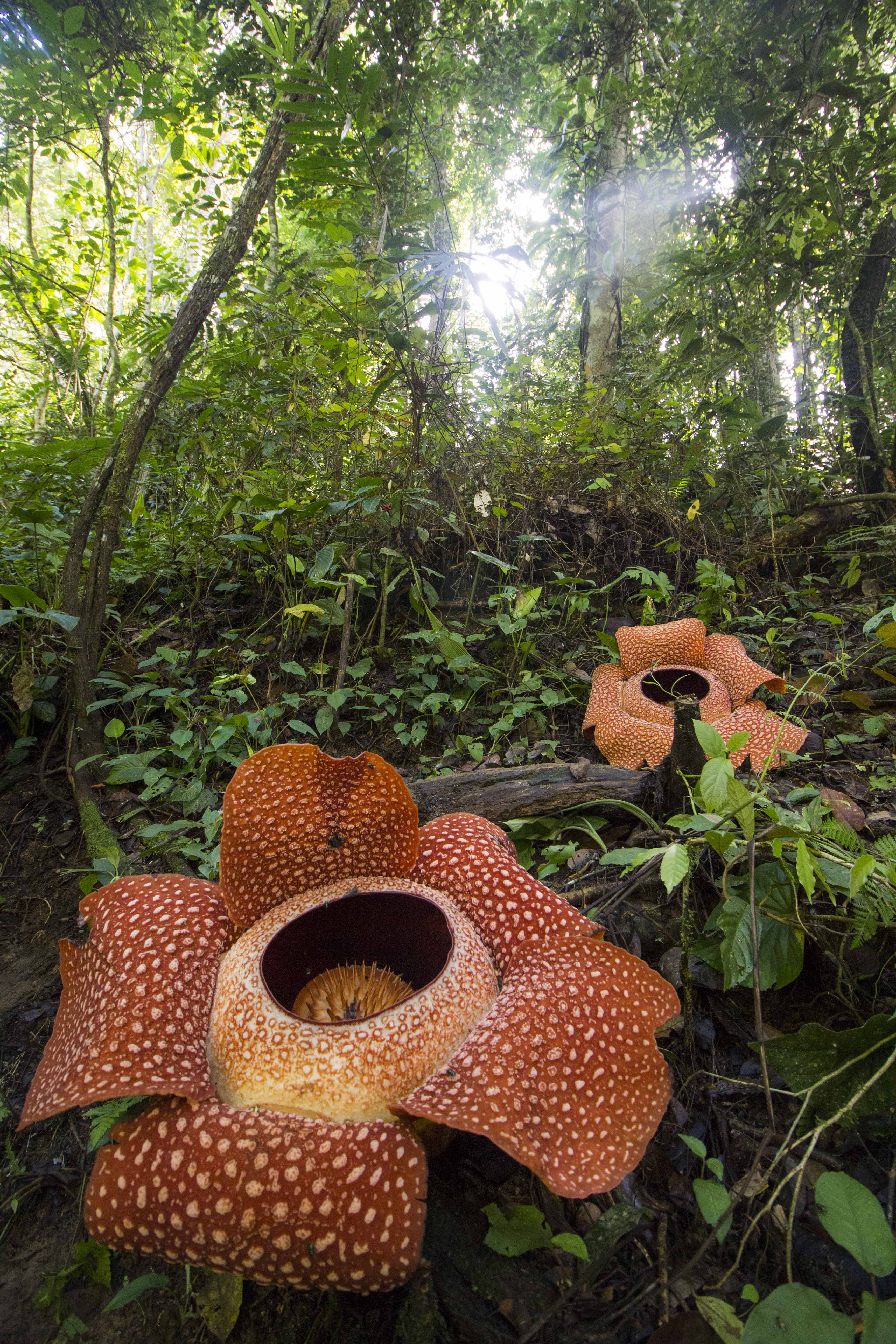
| nickname | Bumi Rafflesia |
| "Land of Rafflesia" | |
| motto | |
| "Many Hands Make the Works Lighter" | |
| mapframe | yes |
| mapframe-zoom | 8 |
and largest city 22% Javanese 18% Lembak/Serawai 5% Chinese 4.3% Minangkabau 13% other 4% Christianity 1% other Rejangese, Bengkulu Malay, Serawai, Lembak, etc. "Land of Rafflesia" "Many Hands Make the Works Lighter" | mapframe-zoom = 8 Bengkulu (, ), historically known as Bencoolen, is a province of Indonesia. It is located on the southwest coast of Sumatra. It was formed on 18 November 1968 by separating out the area of the historic Bencoolen Residency from the province of South Sumatra under Law No. 9 of 1967 and was finalized by Government Regulation No. 20 of 1968. Spread over 20,181.53 km2, its land area is comparable to the European country of Slovenia or the U.S. state of Massachusetts or Ivanovo Oblast and it is bordered by the provinces of West Sumatra to the north, Jambi to the northeast, Lampung to the southeast, and South Sumatra to the east, and by the Indian Ocean to the northwest, south, southwest, and west.
Bengkulu is the 28th largest province by area; it is divided into nine regencies and the city of Bengkulu, the capital and the only independent city. Bengkulu is also the 26th largest province by population in Indonesia, with 1,715,518 inhabitants at the 2010 Census and 2,010,670 at the 2020 Census; the official estimate as at mid 2024 was 2,115,631 (comprising 1,065,992 males and 1,020,014 females in mid 2023). According to a release by Badan Pusat Statistik, it has the eleventh highest Human Development Index among the provinces, with a score of about 0.744 in 2013. By 2014, the province is positioned 28th highest in gross domestic product and 20th highest in life expectancy, 70.35 years.
Bengkulu also includes offshore Mega Island and Enggano Island in the Indian Ocean. Bengkulu has 525 kilometres of coastline along the Indian Ocean on its western side, from Dusun Baru Pelokan in Mukomuko Regency to Tebing Nasal in Kaur Regency. Bengkulu has many natural resources such as coal and gold, and has big and potential geothermal resources. However, it is less developed than other provinces in Sumatra.
Etymology
Traditional sources suggest that the name Bengkulu or Bangkahulu derived from the word bangkai and hulu which means 'carcasses located in a stream'. According to the story, there was once a war between small kingdoms in Bengkulu, resulting in many casualties from both sides in the streams of Bengkulu. These casualties soon rotted as they were not buried, lying in river streams. This etymology is similar to the story of a war between the Majapahit Empire and the Pagaruyung Kingdom in Padang Sibusuk, an area once ruled by the Dharmasraya empire, which also derives the name Padang Sibusuk from casualties rotting on the battlefield. During the European colonial era, the region was known as Bencoolen or British Bencoolen.
History

The region was subject to the Buddhist Srivijaya empire in the 8th century. The Shailendra Kingdom and Singosari Kingdom succeeded the Srivijaya but it is unclear whether they spread their influence over Bengkulu. The Majapahit also had little influence over Bengkulu. There were only few smalls 'kedatuan' based on ethnicity such as in Sungai Serut, Selebar, Pat Petulai, Balai Buntar, Sungai Lemau, Sekiris, Gedung Agung and Marau Riang. It became a vassal region of the Banten Sultanate (from Western Java) in the early 15th century and since the 17th century was ruled by Minangkabau's Inderapura Sultanate (today's in Pesisir Selatan, West Sumatra Province).

The first European visitors to the area were the Portuguese, followed by the Dutch in 1596. The British East India Company established a pepper-trading center and garrison at Bengkulu (Bencoolen) in 1685. In 1714 the British built Fort Marlborough, which still stands. The trading post was never profitable for the British, being hampered by a location which Europeans found unpleasant, and by an inability to find sufficient pepper to buy. It became an occasional port of call for the EIC's East Indiamen.
In 1785, the area was integrated into British Empire as Bencoolen, while the rest of Sumatra and most of the Indonesian archipelago was part of the Dutch East Indies. Sir Stamford Raffles was stationed as Lieutenant-Governor of Bencoolen (the colony was subordinate at the time to the Bengal Presidency) from 1818 to 1824, enacting a number of reforms including the abolition of slavery, and the British presence left a number of monuments and forts in the area. Despite the difficulties of keeping control of the area while Dutch colonial power dominated the rest of Sumatra, the British persisted, maintaining their presence for roughly 140 years before ceding Bengkulu to the Dutch as part of the Anglo-Dutch Treaty of 1824 in exchange for Malacca. Bengkulu then remained part of the Dutch East Indies until the Japanese occupation in World War 2.

During the early 1930s, Sukarno, the future first president of Indonesia, was imprisoned by the Dutch and briefly resided in Bengkulu, where he met his wife, Fatmawati. The couple had several children, including Megawati Sukarnoputri, who later became Indonesia's first female President.
After independence, Bengkulu was initially part of the 'South Sumatra' Province, which also included Lampung, the Bangka-Belitung Islands, and what is now South Sumatra itself, as a Residency. In 1968, Bengkulu gained provincial status, becoming the 26th province of Indonesia, preceding East Timor.
Bengkulu lies near the Sunda Fault and is prone to earthquakes and tsunamis. The June 2000 Enggano earthquake killed at least 100 people. A recent report predicts that Bengkulu is "at risk of inundation over the next few decades from undersea earthquakes predicted along the coast of Sumatra" A series of earthquakes struck Bengkulu during September 2007, killing 13 people.
Geography and climate
The western part of Bengkulu province, bordering the Indian Ocean coast, is about 576 km along, and the eastern part of the condition is hilly with a plateau that is prone to erosion. Bengkulu Province is on the west side of the Bukit Barisan mountains. The province's area is about 20,130.21 square kilometres, or slightly smaller than the European country,Slovenia.The province extends from the border province of West Sumatra to the border province of Lampung; the distance is about 567 kilometres. Bengkulu Province lies between 2° 16' S and 03° 31' S latitude and 101° 01'-103° 41'E longitude. Bengkulu province in the north borders the province of West Sumatra, in the southern the Indian Ocean and Lampung province, in the west it borders the Indian Ocean and in the east the provinces of Jambi and South Sumatra. Bengkulu province is also bordered by the Indian Ocean coastline of approximately 525 kilometres to the west. Its western part is hilly with fertile plateaus, while the western part is lowland relatively narrow, elongated from north to south and punctuated bumpy areas.
Bengkulu's climate is classified as tropical. Bengkulu has a large amount of rainfall throughout the year, even in the driest month. The climate here is classified as Af by the Köppen-Geiger system. The annual average temperature is 26.8 °C. The average annual rainfall is 3360 mm.
The total area of Bengkulu province is 20,181.53 km2. For administrative purposes, the province is divided into nine regencies and one city, together sub-divided into 93 districts.
| Jan record high C = 33.7 | Feb record high C = 35.2 | Mar record high C = 34.4 | Apr record high C = 34.8 | May record high C = 35.4 | Jun record high C = 34.9 | Jul record high C = 35.0 | Aug record high C = 33.9 | Sep record high C = 34.0 | Oct record high C = 33.9 | Nov record high C = 33.8 | Dec record high C = 34.0 | year record high C = | Jan record low C = 20.5 | Feb record low C = 20.2 | Mar record low C = 20.4 | Apr record low C = 20.5 | May record low C = 20.3 | Jun record low C = 20.5 | Jul record low C = 19.8 | Aug record low C = 19.5 | Sep record low C = 18.1 | Oct record low C = 20.5 | Nov record low C = 20.3 | Dec record low C = 20.8 | year record low C =
| access-date = 19 October 2023}}
Population
|1971 |519316 |1980 |768064 |1990 |1179122 |1995 |1409117 |2000 |1567436 |2010 |1715518 |2015 |1872136 |2020 |2010670 |2024 |2115631}}
The 2010 census reported a population of 1,715,518 including 875,663 males and 837,730 females; by the 2020 Census this had risen to 2,010,670, and the official estimate for mid 2024 was 2,115,631.
Ethnic groups

Bengkulu is home to various indigenous ethnic groups. The Rejangs form the majority of the province with 60.4% of the population. The second largest ethnic group is the Javanese forming around 24%. Other minority indigenous ethnic groups includes Lembak, Serawai, Pekal, Enggano, Pasemah, Minangkabau and Bengkulu Malays. There is also non-indigenous ethnic groups that mostly came from other parts of Indonesia such as Sundanese, Javanese, Acehnese, Madurese, Batak, Chinese and others.
Religion

The 2022 data of Ministry of Religious Affairs found 97.69% of the population as adherents to Islam and 2% as Christian. The remainder includes Hindus (0.20%) who are mostly Balinese migrants, Buddhists (0.1%), and "other" including traditional beliefs (0.004%).
Languages
Like the rest of Indonesia, Indonesian is the official language for formal occasions, institutions, and government affairs while local languages are widely used in daily life.
Most indigenous languages in Bengkulu belong to the Malayan group of Austronesian languages, such as Bengkulu Malay, Lembak, Pekal and Minangkabau varieties. The most widely spoken language in the province, Rejang, is the only Bornean language to be spoken in Sumatra (and one of three outside of Borneo other than Malagasy in Madagascar and Yakan in Basilan).
Engganese is classified as a highly divergent branch of Malayo-Polynesian, however, this is still debated.. A less-studied language is Nasal language, which may be related to Rejang or form its own branch of Malayo-Polynesian. Non-indigenous ethnic groups also speak their own language/dialects.
Government and administrative divisions

When it was formed in 1967 from the western parts of South Sumatra province, Bengkulu Province consisted of three regencies - Bengkulu Selatan (South Bengkulu), Bengkulu Utara (North Bengkulu), and Rejang Lebong - together with the independent city of Bengkulu, which lies outside any regency. Five additional regencies were established on 25 February 2003 - Kaur Regency and Seluma Regency from parts of Bengkulu Selatan, Kepahiang Regency and Lebong Regency from parts of Rejand Lebong Regency, and Mukomuko Regency from part of Bengkulu Utara. A ninth regency (Bengkulu Tengah, Central Bengkulu) was formed on 24 June 2008 from another part of Bengkulu Utara. The regencies and city are listed below with their areas and their populations at the 2010 and 2020 Censuses, together with the official estimates as at mid 2024.
| Kode | ||||
|---|---|---|---|---|
| Wilayah | Name of | |||
| City or | ||||
| Regency | Area | |||
| in | ||||
| km2 | Pop'n | |||
| Census | ||||
| 2010 | Pop'n | |||
| Census | ||||
| 2020 | Pop'n | |||
| Estimate | ||||
| mid 2024 | Capital | HDI | ||
| 2014 Estimates | ||||
| 17.71 | ||||
| 17.09 | ||||
| 17.04 | ||||
| 17.08 | ||||
| 17.07 | ||||
| 17.06 | ||||
| 17.03 | ||||
| 17.02 | ||||
| 17.05 | ||||
| 17.01 | ||||
Note: (a) includes Enggano Island and neighbouring small islands in the Indian Ocean.
The province forms one of Indonesia's 84 national electoral districts to elect members to the People's Representative Council. The Bengkulu Electoral District consists of all of the 9 regencies in the province, together with the city of Bengkulu, and elects 4 members to the People's Representative Council.
Economy
Three active coal mining companies produce between 200,000 and 400,000 tons of coal per year, which is exported to Malaysia, Singapore, South Asia, and East Asia. Fishing, particularly tuna and mackerel, is an important activity. Agricultural products exported by the province include ginger, bamboo shoots, and rubber.
Coat of arms
The coat of arms of Bengkulu is in the shape of a shield inscribed with the word "Bengkulu". Inside the shield are a star, a cerana (traditional container), a rudus (traditional weapon), a Rafflesia arnoldii flower, and stalks of rice and coffee.
The star symbolizes belief in God Almighty. The cerana represents high culture, while the rudus signifies heroism. The Rafflesia arnoldii reflects Bengkulu’s natural uniqueness. Rice and coffee symbolize prosperity. The emblem also contains waves with 18 lines, 11 coffee leaves, six coffee flowers on each stalk, and eight stalks in total — together symbolizing 18 November 1968, the date of Bengkulu’s establishment as a province.

Notes
References
- Reid, Anthony (ed.). 1995. Witnesses to Sumatra: A traveller's anthology. Kuala Lumpur: Oxford University Press. pp. 125–133.
- Reprints of British-era primary source material
- Wilkinson, R.J. 1938. Bencoolen. Journal of the Malayan Branch Royal Asiatic Society. 16(1): 127–133.
- Overview of the British experience in Bencoolen
Cocos (Keeling) Islands, Australia British Indian Ocean Territory, United Kingdom Addu Atoll, Maldives
References
- Badan Pusat Statistik, Jakarta, 28 February 2025, ''Provinsi Bengkulu Dalam Angka 2025'' (Katalog-BPS 1102001.17)
- (February 11, 2009). "Bengkulu Lumbung Nasionalis yang Cair". epaper.kompas.com.
- (2024). "Indeks Pembangunan Manusia 2024". [[Statistics Indonesia]].
- Biro Pusat Statistik, Jakarta, 2011.
- Badan Pusat Statistik, Jakarta, 2021.
- EJOLT. "Bengkulu Coal-fired Power Plant, Indonesia {{!}} EJAtlas".
- Sari, Meri Maya. (2017-04-21). "Kajian Efektivitas Pelaksanaan Amdal Bidang Energi Dan Sumber Daya Mineral Dalam Pelestarian Kawasan Lindung di Kabupaten Bengkulu Tengah". Jurnal Pengelolaan Sumberdaya Alam Dan Lingkungan (Journal of Natural Resources and Environmental Management).
- "A History on the Honourable East India Company's Garrison on the West Coast of Sumatra 1685–1825".
- "Bencoolen (Bengkulen)".
- (1996). "International Dictionary of Historic Places, Volume 5: Asia and Oceania". Fitzroy Dearborn Publishers.
- "Bencoolen, Fort Marlborough of the East India Company".
- Roberts, Edmund. (1837). "Embassy to the Eastern Courts of Cochin-China, Siam, and Muscat". Harper & Brothers.
- "Indonesia - Toward independence {{!}} Britannica".
- Andrew C. Revkin. (2006-12-05). "Indonesian Cities Lie in Shadow Of Cyclical Tsunami". [[The New York Times]] (Late Edition (East Coast)) p. A.5.
- "With Every Rumble, Indonesians Fear Additional Ruin (Published 2007)".
- "Bengkulu {{!}} province, Indonesia {{!}} Britannica".
- "SEKILAS BENGKULU".
- "Jumlah Penduduk Bengkulu 1,7 Juta Jiwa {{!}} Harian Berita Sore".
- (31 August 2022). "Jumlah Penduduk Menurut Agama". [[Ministry of Religious Affairs (Indonesia).
- "Indeks-Pembangunan-Manusia-2014".
- Law No. 7/2017 (''UU No. 7 Tahun 2017'') as amended by Government Regulation in Lieu of Law No. 1/2022 and Regulation of General Elections Commission No. 6/2023.
This article was imported from Wikipedia and is available under the Creative Commons Attribution-ShareAlike 4.0 License. Content has been adapted to SurfDoc format. Original contributors can be found on the article history page.
Ask Mako anything about Bengkulu — get instant answers, deeper analysis, and related topics.
Research with MakoFree with your Surf account
Create a free account to save articles, ask Mako questions, and organize your research.
Sign up freeThis content may have been generated or modified by AI. CloudSurf Software LLC is not responsible for the accuracy, completeness, or reliability of AI-generated content. Always verify important information from primary sources.
Report