From Surf Wiki (app.surf) — the open knowledge base
Bayou Teche
Waterway in Louisiana, U.S.

Waterway in Louisiana, U.S.
| Field | Value |
|---|---|
| name | Bayou Teche |
| map | |
| map_caption | Bayou Teche |
| source1_coordinates | |
| mouth_coordinates | |
| source1_location | Bayou Courtableu at Port Barre, St. Landry Parish |
| mouth_location | Lower Atchafalaya River near Patterson, St. Mary Parish |
| cities | |
| subdivision_type1 | Country |
| subdivision_name1 | United States |
| subdivision_type2 | States |
| subdivision_name2 | Louisiana |
| subdivision_type3 | Parishes |
| subdivision_name3 | |
| length | 125 mi |
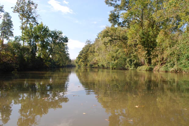
| image_caption | Bayou Teche at its intersection with the Wax Lake outlet of the Atchafalaya River in St Mary Parish, Louisiana. The bayou runs bottom–top in the picture. View is to the west-northwest. |
| native_name | frc |
Bayou Teche (Louisiana French: Bayou Têche) is a 125 mi waterway in south central Louisiana in the United States. Bayou Teche was the Mississippi River's main course when it developed a delta about 2,800 to 4,500 years ago. Through a natural process known as deltaic switching, the river's deposits of silt and sediment cause the Mississippi to change its course every thousand years or so.
History
The Teche begins in Port Barre where it draws water from Bayou Courtableau and then flows southward to meet the Lower Atchafalaya River at Patterson. During the 18th-century Acadian migration to the area - then known as the Attakapas region - the Teche was the primary means of transportation.
During the American Civil War, there were two naval engagements on Bayou Teche. The Confederate navy had a gunboat on the bayou, the , which was partially armored with railroad iron. On November 3, 1862, four Union gunboats, , , , and , moved up the Bayou to engage the Cotton. All four Union ships were damaged, but the Cotton was forced to withdraw.

The second engagement occurred on 14 January 1863. Union general Godfrey Weitzel learned that the J. A. Cotton was planning an attack on Weitzel's forces at Berwick Bay, Louisiana. Once again Kinsman, Calhoun, Estrella and Diana steamed into the Bayou, followed by Union transports. The bayou had been obstructed with debris. The Union gunboats and land-based units engaged the J. A. Cotton and Confederate infantry in rifle pits. During the battle Kinsman hit a mine and unshipped her rudder; the J. A. Cotton was badly damaged, and her crew set her on fire during the night to prevent capture. The Union, however, was unable to hold the Teche, necessitating two more invasions of the Teche country in 1863 and 1864, referred to as the Bayou Teche campaign.
After the levees were built along the Atachafalaya River in the 1930s, the Teche and the rice farms located along the bayou suffered a drastic reduction in fresh water. Between 1976 and 1982, the United States Army Corps of Engineers built a pumping station at Krotz Springs to pump water from the Atchafalaya River into Bayou Courtableau.
The etymology of the name "Teche" is uncertain. One hypothesis is that it comes from "tenche", a Chitimacha Indian word meaning "snake", related to the bayou's twists and turns resembling a snake's movement. The Chitimacha tell an ancient story of how the snake attacked their villages, and it took many warriors many years to kill it. Where the huge carcass lay and decomposed, the depression it left behind filled with water to become the bayou. Alternatively, George R. Stewart asserts that it is "probably a French rendering of Deutsch, the name by which the German colonists of the area would have named their stream. Cf. Allemand ['German']."

Towns on Bayou Teche
Towns along the Teche include:
- St. Landry Parish, Louisiana
- Port Barre, Louisiana
- Leonville, Louisiana
- Arnaudville, Louisiana
- St. Martin Parish, Louisiana
- Cecilia, Louisiana
- Breaux Bridge, Louisiana
- Parks, Louisiana
- St. Martinville, Louisiana
- Iberia Parish, Louisiana
- Loreauville, Louisiana
- Morbihan, Louisiana
- New Iberia, Louisiana
- Jeanerette, Louisiana
- St. Mary Parish, Louisiana
- Charenton, Louisiana
- Baldwin, Louisiana
- Franklin, Louisiana
- Garden City, Louisiana
- Centerville, Louisiana
- Patterson, Louisiana
- Berwick, Louisiana
References
References
- U.S. Geological Survey. National Hydrography Dataset high-resolution flowline data. [http://viewer.nationalmap.gov/viewer/ The National Map] {{webarchive. link. (2012-03-29 , accessed June 20, 2011)
- (2008). "Voices of the Confederate Navy: Articles, Letters, Reports, and Reminiscences". McFarland.
- (29 January 2008). "Planting the Union Flag in Texas: The Campaigns of Major General Nathaniel P. Banks in the West". Texas A&M University Press.
- "Kinsman".
- (2011). "Confederate Torpedoes: Two Illustrated 19th Century Works with New Appendices and Photographs". McFarland.
- Louisiana Department of Culture, Recreation and Tourism. "Bayou Teche Historical Marker".
- George R. Stewart ''American Place-names'' (New York: Oxford University Press, 1970), p. 475.
This article was imported from Wikipedia and is available under the Creative Commons Attribution-ShareAlike 4.0 License. Content has been adapted to SurfDoc format. Original contributors can be found on the article history page.
Ask Mako anything about Bayou Teche — get instant answers, deeper analysis, and related topics.
Research with MakoFree with your Surf account
Create a free account to save articles, ask Mako questions, and organize your research.
Sign up freeThis content may have been generated or modified by AI. CloudSurf Software LLC is not responsible for the accuracy, completeness, or reliability of AI-generated content. Always verify important information from primary sources.
Report